Joseph Frederick Wallet Des Barres
Colonel Joseph Frederick Wallet Des Barres (1721 - 1824) was a cartographer who served in the Seven Years' War, in part, as the aide-de-camp to General James Wolfe. He also created the monumental four-volume Atlantic Neptune, which was the most important collection of maps, charts, and views of North America published in the eighteenth century. Finally, he was the Governor of Cape Breton Island and Prince Edward Island. Colonel Des Barres is buried in the crypt of St. George's (Round) Church, Halifax, Nova Scotia.
He was born in Basel, Switzerland, and was a member of a Huguenot family. Des Barres read mathematics and art at the University of Basel, studying under John and Daniel Bernoulli. Upon the completion of his studies he left for England.
There he enrolled at the Royal Military Academy, Woolwich. It was there that Des Barres trained to become a military officer, and studied military surveying. His training would also benefit him later in life for surveying, map making, and coastal charting.
In 1756 he was commissioned into the Royal Americans.
In 1756 Des Barres sails to North America and is with Edward Boscawen's fleet when it attacks the Fortress of Louisbourg in 1758.
He distinguishes himself by capturing a French entrenchment at Kennington Cove. Soon he is put to work charting the Gulf of
St. Lawrence and approaches to Quebec, information that will be used the following year in Wolfs's assault on the City of Quebec.
In 1760 he is at Halifax to prepare plans for the city's defenses and naval yard.
By 1762 he is sent to Newfoundland to survey
Harbour Grace and Carbonear to draw up plans for new harbor defenses to replace those destroyed by the French. James Cook was sent as his assistant. (Des Barres may have met Cook earlier at either Louisbourg or Halifax.)
Des Barres made many maps of the Atlantic, mapping the coast of North American from Newfoundland to New York. His survey of the coast of Nova Scotia took approximately ten years due to its length and intricacy.
Des Barres was exasperated with the work stating
"There is scarcely any known shore so much intersected with Bays, Harbours, and Creeks as this is" "and the Offing of it is so full of Islands, Rocks, and Shoals as are almost innumerable."
The survey work was carried out in the summer and in the winter he would retire to his estate,
Castle Frederick, in Falmouth, Nova Scotia to complete his charts and drawings. His most notable work is the Atlantic Neptune.
In 1774 under the direction of the British Admiralty, Des Barres compiled and edited his and many others' charts and maps of eastern North America.
The completed work was published in 1777, having cost the Admiralty an estimated £100,000.
Atlantic Neptune
Des Barres's superb atlas contains the coasts of Nova Scotia (volumes 1
and 2), the coasts and harbors of the Gulf and River of St. Lawrence,
and the Atlantic coast of North America from New York to Mexico (volume
3) and New England (Volume 4). A British military engineer with long
service in America, Des Barres devoted sixteen years to the publication
of his masterpiece. Copies of The Atlantic Neptune were compiled
as they were ordered, principally for naval captains or merchant
mariners, and therefore no standard collation exists and no two recorded
copies will contain the same complement of charts, nor be bound in
exactly the same sequence.
"Nautical charting took an unprecedented leap toward greater precision and graphic sophistication with the publication of Des Barres's Atlantic Neptune... The Neptune provided the first generally accurate charts of many areas, and it was relied upon well into the nineteenth century. Des Barres also
standardized many of the symbols, such as for navigational hazards, that are found on nautical charts to this day... Not only were Des Barres's charts technically superior to earlier works, but they were also objects of fine printing and possessed an artistry that transcended their utilitarian purpose. Moreover, this was achieved on works that were
often breathtakingly large in scale, with some charts measuring over ten feet in length... Most of the surveys on which the charts of the Neptune were based were conducted between 1763 and 1773.
Des
Barres was then commissioned to assemble these surveys, which included his own fine work in Nova Scotia, prepare their engraving, and have them bound into a usable format. Surveys of the New York and New England
areas were carried out by various officers under the command of Major
Samuel Holland, one of the most capable of all colonial cartographers...
In some but not all cases, Des Barres provided the names of the actual surveyors of the charts... When war with the American colonies broke out, the need for good charts of American waters became imperative, and
in the years prior to the war, Des Barres project was given high priority.
Between 1776 and 1779, Des Barres and his more than twenty assistants had taken over two London townhouses to complete the Neptune" (Paul E. Cohen and Robert T. Augustyn, Manhattan in Maps 1527-1995, New York, 1997, pp.66-69). Howes D-271; NMM III:380; Phillips Atlases 1198-1205, 3654-3659; Streeter sale II:706.
DES BARRES, Joseph F. Wallet (1722-1824). The Atlantic Neptune, published for the use of the Royal Navy of Great Britain... under the Directions of
the Right Honble. the Lords Commissioners of the Admiralty. London, [1774-1779].
Four volumes, 2 engraved double-page general titles by H. Ashby after T. Tomkins; 3 engraved section titles; 116 engraved charts, views and elevations as
listed below, most folding or double-page, the principal features tinted or colored by hand, including inset plans, maps and vignette views;
the engraved views and elevations (many with multiple images).
CONTENTS: Typically the atlas contained the following charts
VOLUME I:
Engraved general title, double-page. 1777.
Engraved section title for Nova Scotia, double-page.
Preface, letterpress.
Engraved Contents of Charts, double-page.
Engraved List of Views, double-page.
5. References
6. General Remarks
7. Coast of Nova Scotia, New England, New York... 1777.
8. Chart of Nova Scotia--Bay of Fundy. 1775.
9. [Views] Grandmanan Is. Campo Bello. n.d.
10. [Views] Melchios Riv. Melchios Mills. 1777.
11. River St. John. Inset view of Entrance to Riv. St. John. 1776.
12. [Views] The Wolves, Grand Mahan, Riv. St. John [in two views], Pasamaquady Bay. n.d.
13. Isthmus of Nova Scotia. 1777.
14. [Views] Cape Blowemedown, Cape Split, Spencers Is., Isle Haut. 1777.
15. [Chignecto Bay]. 1777.
16. [Views] Isle Haut, Cape Doré, Cape Baptist, Bason of Mines, Isle Haut, Cape Blowmedown. 1777.
17. [Views] Partridge Is. n.d.
18. Annapolis Royal. -- St. Marys Bay. Inset view of Gulivers Hole. 1776.
19. [Views] Annapolis Bason, Grand Passage, Eden and Gascoyne Rivers, Annapolis Royal, Petit Passage. n.d.
20. [Views] Grand Passage, Cape St. Mary, St. Mary's Bay. n.d.
21. S.E. Part of the Bay of Fundy. 1776.
22. S.W. Coast of the Peninsula of Nova Scotia. 1776.
23. Barrington Bay. 1776.
24. Port Amherst. Port Haldimand. 1775.
25. Port Campbell. 1776.
26. [Views] S.W. Coast of Nova Scotia [in two views], Seal Is., Boston Bay. n.d .
27. [Views] S.W. Coast of Nova Scotia... the Brazil, Cape Sable, Coast of New Hampshire. n.d.
28. Port Mills, Port Mansfield, Gambier Harbour. 1776.
29. Liverpool Bay. 1777.
30. Port Jackson. 1777.
31. Kings Bay. Lunenberg. 1776.
32. Mecklenburgh Bay. 1776.
33. Charlotte Bay. 1776.
34. Leith Harbour, Prospect Har., Bristol Bay, Sambro Har. Inset view of Hopsons Nose. 1775.
35. [Views] Cape Prospect, Highlands of Haspotagoen, Ovens, Cape Sable [in two views]. n.d.
VOLUME II:
Engraved general title, double-page. 1777.
Engraved Contents of Charts [duplicate of that in vol. I]
36. S.E. Coast of Nova Scotia. 1776.
37. Halifax Harbour. Inset views of: Light House, Chebucto Head. n.d.
38. Harbour of Halifax. 1777.
39. [Views] Halifax Har. [in three views], Sambro Lighthouse [in two], Chebucto Head. n.d.
40. [View] Halifax. 1777. [According to the contents leaf, this sheet was meant to be joined with sheet 38. Here it appears as one of two leaves numbered 40. It does not appear separately on the engraved list of views.]
40 [repeated]. Egmont Harbour. n.d. [This is the proper sheet 40 appearing on the list of charts.]
41. Keppell Harbour, Knowles Har., Tangier Har., Saunders Har., Deane Har. Two inset views.
42. [Views] Egmont Har. [in two views], Keppel Har., Falls of Hichinbroke, Chisetcook Inlet, Dartmouth Shore. n.d.
43. Spry Harbour, Port Pallisser, Port North, Port Parker... 1776.
44. White Is. Harbour, Port Stephen's, Liscomb Har... 1776.
45. Sandwich Bay. 1776.
46. Tor Bay. Inset view of Berryhead. 1775.
47. White Haven. 1774.
48. [Durrell Is.--Canso Har.--Glasscow Har.] 1775.
49. [Two single leaves pasted to the same stub, the first containing:] Plan and View of Crow Harbour. n.d. [The second containing on recto the text description of Canso Harbour, on verso the text for St. Peter's Bay.]
50. [St. Peter's Bay--Lenox Passage--Richmond Is.] 1775.
51. Milford Haven. Inset view of the same. 1777.
52. [Views] Land from White Is. to St. Marys Riv., Milford Haven, Port Bickerton, Beaver Har. [in two views], Cranberry Isle... n.d.
53. Conway Harbour. Port Aylesbury. 1776.
54. [Part of Cape Breton--Richmond Isles--Chetabucto Bay.] 1777.
55. [Views] Louisbourg Harbour, Gabbarus Bay, Richmond Is., Cape Breton... n.d.
[Unnumbered sheet] View of Louisbourg Harbour. 1778 Not on the list of views.
56. The Gut of Canso. 1776
57. Northumberland Streights--St. Georges Bay. n.d.
58. Northumberland Streights--Bay Verte. n.d.
59. Port Hood. 1776.
60. [Views] Port Hood, Plaister Cliffs in George's Bay. n.d.
61. Frederick Bay. Pictou Harbour. 1776.
62. Port Shediack, Cocagne. 1776.
63. Isle of Sable. n.d.
64. [Views] Isle of Sable [in five views]. n.d.
65. [Views] Isle of Sable [in four views] n.d.
66. The Isle of Sable. 1778.
67. [View] Naked Sand Hills. Isle of Sable. n.d.
68. Remarks on the Isle of Sable.
VOLUME III:
Engraved title, double-page.
Engraved References, double page.
Manuscript table of contents.
4. [General map of Gulf and Riv. St. Lawrence.] n.d.
5. River St. Lawrence [Cock Cove--Quebec]. n.d.
6. [River St. John--Large Is.--St. Genevieve Is.] 1777.
7. Bay of Seven Is. 1778.
8. Harbour and Bay of Gaspée--Maul Bay. n.d.
9. Bay of Chaleurs. 1777.
10. Miramichi Bay. 1777.
11. Harbours of Rishibucto and Buctush. 1778.
12. Magdalen Is. 1778.
[Unnumbered.] Engraved title, double-page. 1778.
13. Chart of New York Harbour. Two inset views. 1779.
14. Nautical directions to... New York. n.d. Letterpress.
15. A sketch of the operations of...Howe... With text and view of naval engagement. 1777.
16. [Views] Highland of Neversunk. 1777.
17. Oyster Bay, Huntington Bay, Hell Gate. 1778.
18. Plan of Ft. Montgomery and Ft. Clinton. 1779.
19. Harbour of Charlestown in South Carolina. Inset view. 1777.
20. Port Royal in South Carolina. 1777.
21. Savannah. n.d.
22. Savanah River to Inlet of St. Mary. n.d.
23. N.E. Shore of the Gulph of Mexico. 1779.
VOLUME IV:
Letterpress title, n.d.
Manuscript leaf of contents.
Engraved References, double-page.
5. Coast of New England. 1776.
6. [Montauk Pt.--Block Island--Pt. Judith.] 1779.
7. [Newport--Buzzards Bay--Nantucket Island.] 1779.
8. Harbour of Rhode Island and Narraganset Bay. 1776.
9. Plan of Newport. 1776.
10. [Buzzards Bay--Elizabeth Is.--Vineyard Sound.] 1776.
11. [Part of Martha's Vineyard--Nantucket Is.] 1776.
12. [Views] Cape Cod. Deer Is. n.d.
13. Massachusetts Bay. 1776.
14. Plymouth Harbour. n.d.
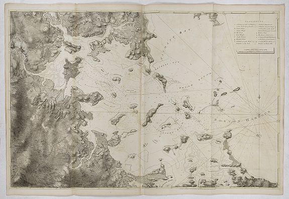
15. Boston Bay. 1776.
16. [Views] Boston Harbour [in four views]. 1777.
17. Harbour of Boston. 1775.
18. View of Boston. 1776.
19. [Views] Boston from Willis Creek... 1775.
20. [Views] Boston from Dorchester Neck... 1775.
21. [View of Castle William.] n.d.
22. Ipswich Bay, Cape Ann. 1776.
23. [Newbury Harbour--Cape Elizabeth.] 1776.
24. Piscataqua Harbour. 1779.
25. View of Portsmouth. n.d.
26. [Views] Castle William. View of Newcastle. n.d.
27. Kennebec River. 1776.
28. Falmouth Harbour. n.d.
29. [Portland Sound--Rogers Bay.] 1776.
30. [Penmaquid Pt.--Seal Harbour.] 1776.
31. Penobscot Bay. Frenchmans Bay. 1776.
32. Penobscot Bay. Great Blue Hill Bay. 1776.
33. Penobscot Bay. Deer Is. n.d.
34. Mount Desart Is. 1776.
35. [Gouldsbourough Moose Harbour.] 1776.
36. [Grand Manan Is.] 1778.
37. [Campo Bello. Deer Is. Pasamaquody Bay.] n.d. (4)

