Mapping of Uzbekistan and the Silk Road
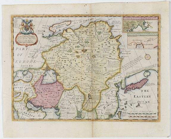

Silk Road

The historic city of Bukhara has been a hub for traders and travelers since its foundation over 2,000 years ago. Situated on an oasis in the Zerafshan River delta in central Uzbekistan, Bukhara lies at the crossroads of ancient trade routes that stretched across Central Asia and was a vital stopping point for merchants on the edge of the Kyzyl Kum (Red Sand) and Kara Kum (Black Sand) deserts. It was one of the most prosperous cities in Central Asia throughout the Middle Ages. It became a center not only for exchange between merchants but also for culture, scholarship, and the study of religion. Bukhara also contributed many locally produced goods that enriched the Silk Road trade and was particularly renowned for its textile industry. 

Karakul lambs' fleeces, silk, cotton, leather, carpets, and clothing were all traded from Bukhara, as well as gold embroidery and metalwork. Many of these crafts are still practiced in the city today.


Bukhara's ancient history was closely intertwined with the growth of the Silk Roads through Central Asia. Indeed, a settlement on the site of Bukhara has been discovered dating from as early as the 2nd millennium BC and the city grew up nourished by the merchants that arrived from Persia, India, China, and Russia, as well as those traveling east from the Caspian Sea and beyond. Its geographical position, on the edge of the deserts yet close to Uzbekistan’s most prosperous agricultural region, made Bukhara a popular and essential resting point in the development of these routes. Following the Arab conquest of the city in 709 AD, Bukhara also became a major cultural and religious center. It was chosen by the Emir Ismail ibn Amad to be the capital city of the independent Samanid kingdom in 892. 

The Emir’s tomb, built in Bukhara in the early 10th century, is one of the most striking and well-preserved examples of Islamic architecture from this period. The city increasingly attracted intellectuals and religious scholars, gaining a reputation as a center of Islamic learning and earning the title of Bukhoro-i-Sharif, or "Noble Bukhara". Scholars and students from across the Muslim world, who gathered in the city to learn and teach, were themselves partaking in the Silk Roads, bringing their own cultures and ideas with them. The city continued to expand economically and socially under the rule of the Karakhanids in the 11th century, up until the invasion by Ghengis Khan in 1220, and became part of the Timurid Empire in 1370. 

However, in the 16th century, Bukhara reached its peak of prosperity and renown as a cultural, trading, and religious center on the Silk Roads.
Conquered in the late 15th century by Khan Sheibani, a nomadic Uzbek tribal leader, the city became the capital of the Khanate of Bukhara under the Sheibanid dynasty. 

As Sheibanid rule expanded and was consolidated over large areas of Central Asia, Bukhara was the first to benefit from this prosperity, and the majority of the most celebrated and striking monuments that distinguish the city today date from this period. Many of these reflect Bukhara's status as a spiritual, cultural, and economic center, including the remarkable Poi-Kalyan complex, which comprises the Kalyan mosque, minaret, and the Mir-i Arab madrassah. 

The Lyabi-Khauz ensemble, the Kosh madrassah, and the Gaukushon madrassah also date from this period. The Taki Sarafon (Dome of the Moneychangers) and the Taki-Tilpak-Furushan (Dome of the Headguard Sellers) both hint at the vibrant commercial activity that was taking place in Bukhara during this period. The Magoki Kurns and Abdullaziz-Khan madrassah were added in the mid-17th century. 

This historic old town is, in fact, the most complete example of a medieval city in Central Asia today. Its well-preserved urban structure, striking medieval architecture, and the remains of many covered bazaars all reflect the influence of the Silk Roads throughout Bukhara's long history.

Mapping of Usbek
Ancient cartography shows that the Central Asian region was referred to as Usbek (Usbec, Usbeck, Vsbek) or Usbekia (Usbechia) in political world maps published in Western Europe during the 16th-18th centuries. Some territories within this region were called Usbek Bucharia, Usbek Bochara, Usbek Chowaresmia, Usbek Mawaralnahra, Usbek Turkestan, Usbek Turan, Usbek Tartaria, and Usbek Zagatay.

More than two hundred historical maps have been recorded with terms such as Usbeck, Usbekia, and Özbegistan.
These maps show that the name ‘Uzbekistan’ was not invented by the Russians in 1924. Instead, toponyms such as Usbeck and Usbekia, which were used in the political and historical-geographical system of Europe in the Middle Ages, are Latin forms of the place name for the land of the Uzbeks – Özbegistan.
These terms were used to refer to Central Asia in the 16th–18th centuries, specifically to describe the states of the Shaybanids and Ashtarkhanids. Later, the centers of these states were divided into several Uzbek khanates, which Europeans then used in their maps. On maps, the toponym ‘Uzbekistan’ was used as a synonym for the historical term ‘Turkestan’.
Both ethnonymies, Turkestan and Uzbekistan, politically united various ethnically related clans in the 16th to 18th centuries.

The development of cartography in Europe dates back to the Renaissance period, specifically the 15th and 16th centuries. By this time, caravan travel along the Silk Road had ceased and Europeans had begun to travel by sea to India and China. As a result, Central Asia remained outside the focus of European travelers and cartographers. In the first quarter of the 18th century, however, the situation changed. Travelers sent to Central Asia as spies by the Russian ruler Peter I and the Iranian ruler Nadir Shah drew new maps of the region. The geographical and ethnographic information on these maps should be considered primary sources.

Two of the most important maps of the region are:
- The map by Abraham Maas (1728).
- The map showing the Caspian and Aral Seas (Sharta, in qua cruditis spectanda exhibeteur pas Asiae [...] Tabula Maris Caspii et Maris Aral), by Basilios Battatzis, published in London in 1732.

The same cartography of Central Asia was used without change on maps and globes. In Great Britain, the most advanced country in Europe in geography and cartography during the 18th–19th centuries, the term ‘Uzbekistan’ was widely used for at least 135 years (from 1730 to 1865), and this name was reflected in all scientific literature and educational globes related to geography. The maps and globes produced in Britain after 1865 showed the Central Asian region as ‘TURKESTAN’.
This was because, after the Russian invasion, the historical term ‘Uzbekistan’ had been removed by the colonizers. A governorate was established and the name ‘Turkestan’ was used on maps and globes to refer to the Central Asian region. In short, during the 16th–18th centuries, the peoples of Central Asia were at different stages of socio-political development. The nomadic Uzbek tribes from the Dasht-i Kipchak (Kipchak steppe) gained political power in the region from the 16th century. 

In the 16th – 18th centuries, the Uzbeks had a unified territory, a single written literary language and a common culture. Therefore, on the political maps and globes of the time, the country was referred to as Usbeck, Usbekia, and Özbegistan.
Consequently, the toponym ‘Uzbekistan’ was used in the 16th – 18th centuries and even until 1865 (before the Russian invasion) as a synonym for the names Turan and Turkestan, covering the entire Central Asian region. Thus, there is ample reason to consider ‘Uzbekistan’ as one of the historical names for the whole of Central Asia. In world-historical geography, this term, along with Turan and Turkestan, was used as a macrotoponym for the entire Central Asian region for 365 years, until 1865.
At the same time, the term ‘Uzbek’ also had a unifying ethnopolitical and ethnocultural meaning during this period, serving as a superethnos for all peoples living in Central Asia.



Silk Road

The Silk Road

Humans have permanently moved from place to place and traded with their neighbors, exchanging goods, skills, and ideas. Throughout history, Eurasia was crisscrossed with communication routes and trade paths, which gradually linked up to form what is known today as the Silk Roads, routes across both land and sea, along which silk and many other goods were exchanged between people worldwide.

Maritime routes were an essential part of this network, linking East and West by sea, and were used for the trade of spices in particular, thus becoming known as the Spice Routes.

These vast networks carried more than just merchandise and precious commodities; the constant movement and mixing of populations also transmitted knowledge, ideas, cultures, and beliefs, profoundly impacting Eurasian peoples' history and civilizations.

Travelers along the Silk Roads were attracted not only by trade but also by the intellectual and cultural exchange that was taking place in cities along the Silk Roads, many of which developed into hubs of culture and learning. Science, arts, and literature, as well as crafts and technologies, were thus shared and disseminated across societies along these routes, and in this way, languages, religions, and cultures developed and influenced one another.

Silk Road is a relatively recent term, and for most of their long history, these ancient roads had no particular name. In the mid-nineteenth century, the German geologist Baron Ferdinand von Richthofen named the trade and communication network Die Seidenstrasse(the Silk Road), and the term, also used in the plural, continues to stir imaginations with its evocative mystery.

The Silk Road extended approximately 6,437 kilometers (4,000 miles) across some of the world’s most formidable landscapes, including the Gobi Desert and the Pamir Mountains.
View our maps depicting maps of Central Asia and the Far East, or maps showing the trade and caravan routes.

The Silk Road, a network of routes connecting Constantinople (Turkey) and Xián (China), covered all of Central Asia. For fifteen centuries, it was the dominant force in international trade.

An abundance of goods traveled along the Silk Road. Merchants carried silk from China to Europe, where it was worn by royalty and wealthy patrons. Other Asian favorite commodities included jade and other precious stones, porcelain, tea, and spices. In exchange, horses, glassware, textiles, and ma

The network of routes, which included cities like Constantinople (Turkey) and Xián (China), crosses all of Central Asia. 

Interesting reading: https://en.unesco.org/silkroad

The Silk Road and Uzbekistan: Crossroads of Empires, Ideas, and Trade

Introduction

For fifteen centuries, a sprawling web of caravan tracks, mountain passes, oasis towns, and river crossings linked the Pacific coast of China to the shores of the Mediterranean. Along these routes passed silk and spices, paper and gunpowder, glass and lapis lazuli, horses and enslaved people, and—perhaps more consequentially than any commodity—ideas. Religions, scripts, artistic styles, astronomical knowledge, and entire cosmologies moved along these roads as readily as bolts of cloth. Today we call this network the Silk Road, though the peoples who built, maintained, and profited from it for most of its history had no single name for it at all.
At the very heart of this network, geographically and historically, lies the territory of modern Uzbekistan. No other region can claim such a central and enduring role in the story of Eurasian exchange. Samarkand, Bukhara, and Khiva were not simply stops along the way; at various points in history, they were the wealthiest, most learned, and most architecturally magnificent cities between Europe and China. To understand the Silk Road is, in large part, to understand Uzbekistan—its oasis cities, its Sogdian merchants, its Timurid patrons of science and art, and its long, complicated relationship with the European mapmakers who tried, often imperfectly, to render it onto paper.
This article traces the history of the Silk Road from its ancient origins to its eventual eclipse by maritime trade, explores the commodities and ideas that moved along it, profiles the great cities that anchored it, and examines in detail the unique position occupied by the lands of present-day Uzbekistan—including the fascinating and often overlooked history of how European cartographers named, mapped, and misunderstood this region across four centuries.

What Was the Silk Road?

The Silk Road was never a single road. It was a shifting, branching network of overland and maritime routes that connected East Asia, Central Asia, South Asia, the Middle East, and Europe. At its greatest extent, the overland network stretched some 6,400 kilometers (about 4,000 miles) from Xi’an in China to Constantinople on the Bosphorus, with countless spurs reaching south into India, north into the steppe, and west into the Levant and North Africa.
The routes were shaped entirely by geography. Merchants moving goods across Asia had to contend with the Taklamakan and Gobi deserts, the Pamir and Tian Shan mountain ranges, and vast stretches of arid steppe. Rather than crossing these obstacles directly, caravans followed a chain of oases, river valleys, and mountain passes where water, pasture, and shelter could be found. This is why certain cities—Kashgar, Samarkand, Bukhara, Merv, Herat—grew so wealthy: they were not merely convenient stopping points but essential ones, without which the crossing of the deserts or the mountains would have been impossible.
Trade along these routes is documented as early as the second millennium BC, when lapis lazuli from Afghanistan’s Badakhshan mines was already reaching Mesopotamia and Egypt. But the network as a coherent system of long-distance trade is generally traced to the Han Dynasty of China, particularly following the diplomatic and military missions of the Chinese envoy Zhang Qian in the second century BC. Zhang Qian was sent west by the Han court to seek alliances against the nomadic Xiongnu confederation, and though his mission failed in its immediate diplomatic aims, his reports on the kingdoms of Central Asia—their horses, their crops, their markets—opened Chinese eyes to a wider world and set in motion centuries of exchange.
It is worth noting that the term “Silk Road” itself is a modern invention. For most of its long history, this network had no single name in any of the languages of the peoples who used it. It was the German geographer and geologist Ferdinand von Richthofen who, in 1877, coined the term die Seidenstraße—the Silk Road—to describe the trade network across which Chinese silk had historically traveled to the Roman world. The name stuck, entering English, French, and eventually every major world language, and it continues to carry an evocative, almost romantic charge, conjuring images of camel caravans crossing moonlit deserts. The reality was, of course, more mundane and more remarkable in equal measure: a complex commercial system built on credit, contracts, multilingual intermediaries, caravanserais, customs posts, and generations of accumulated geographic knowledge.

Goods, Ideas, and the Machinery of Exchange

Silk gave the network its modern name, but it was far from the only commodity that moved along these routes—and in truth, by the time silk reached the Mediterranean, it had usually changed hands many times over, its price inflated at every stage by the merchants, tax collectors, and intermediaries who handled it.
From China came silk, of course, along with porcelain, lacquerware, tea, paper, and gunpowder. From Central Asia came horses—prized above almost anything else, particularly the famous “heavenly horses” of Ferghana that Chinese emperors coveted for their military campaigns—as well as jade, felt, and the wool and hides of steppe animals. From India came spices, cotton textiles, precious stones, and ivory. From Persia and the Middle East came glassware, carpets, dried fruits, and metalwork. From the Mediterranean world came wine, olive oil, coral, and various manufactured goods.
But it was the intangible cargo that mattered most in the long run. Buddhism traveled from India into Central Asia and China along these routes, carried by monks and pilgrims who established monasteries at oasis towns that became centers of translation and scholarship. Manichaeism, Nestorian Christianity, and Zoroastrianism all found audiences far from their points of origin. Centuries later, Islam spread eastward along the same corridors, transforming Central Asia into one of the great intellectual centers of the medieval Islamic world. Papermaking technology moved from China to the Islamic world—famously, so the story goes, following the capture of Chinese papermakers at the Battle of Talas in 751—and from there eventually to Europe, where it would help make possible the print revolution centuries later. Astronomical knowledge, mathematical concepts (including the decimal system and the concept of zero, which originated in India), medical practices, and artistic motifs all diffused through the same channels that carried silk and spices.
None of this exchange happened automatically. It depended on an entire infrastructure of trust and logistics: caravanserais where merchants and animals could rest safely; local rulers who taxed trade but also protected it, since their own prosperity depended on caravans continuing to pass through their territory; multilingual translators and guides; systems of credit and letters of exchange that allowed merchants to avoid carrying large sums of precious metal across dangerous terrain; and a shared, if informal, code of commercial conduct that made it possible for a merchant from Sogdiana to do business with a partner in Chang’an whom he might never meet in person.
The Sogdians, whose homeland was centered in the Zerafshan Valley of what is now Uzbekistan, were perhaps the most successful practitioners of this long-distance trade. From roughly the fourth to the eighth centuries AD, Sogdian merchants dominated the overland trade between China and the West, establishing diaspora communities in cities as far away as the Chinese capital of Chang’an and the Mongolian steppe. Sogdian became something of a lingua franca of the trade routes, and Sogdian merchants are documented in Chinese sources as far east as the Yellow River valley. Their success was built precisely on their position: their homeland sat astride the routes connecting the settled agricultural civilizations of China, India, and Persia with the nomadic peoples of the steppe, and they made themselves indispensable as intermediaries.

Maritime Routes: The Spice Roads

While the overland Silk Road dominates popular imagination, it was complemented—and eventually largely superseded—by maritime routes connecting East Asia, Southeast Asia, India, the Arabian Peninsula, East Africa, and the Mediterranean. These sea lanes are sometimes called the Maritime Silk Road or the Spice Routes, since they were especially associated with the trade in pepper, cinnamon, cloves, nutmeg, and other spices from the Indonesian archipelago and South India.
The maritime routes had certain advantages over the overland ones: ships could carry far greater volumes of cargo than camel caravans, and sea transport avoided the tolls, taxes, and political instability that could plague any given stretch of the overland network. Chinese, Indian, Persian, Arab, and later Portuguese, Dutch, and English mariners all played roles in developing and dominating different segments of this maritime network at different points in history. The rise of the maritime routes, particularly from the fifteenth century onward as European powers developed the ships and navigational techniques to sail directly to Asia around the Cape of Good Hope, would eventually contribute to the decline of the overland Silk Road’s economic importance—a development with profound consequences for the cities of Central Asia that had built their prosperity on controlling the land routes.

The Great Cities of the Silk Road

Certain cities recur throughout the history of the Silk Road as indispensable nodes in the network—places where goods were bought, sold, stored, taxed, and where travelers from radically different cultures met, traded, and sometimes settled permanently.
Xi’an (Chang’an), China. The eastern terminus of the overland Silk Road, Xi’an was for centuries one of the largest and most cosmopolitan cities on earth. As the capital of the Han and later the Tang Dynasty, it hosted merchant communities from across Asia and the Middle East, and its markets were famous for the exotic goods brought by camel caravan from the west.
Kashgar, in the Tarim Basin. Perched at the western edge of the Taklamakan Desert, Kashgar was the last major oasis before caravans faced the punishing crossing of the Pamir Mountains into Central Asia, or turned south toward India via the Karakoram passes. Its markets remain famous even today.
Samarkand, Bukhara, and Merv, in Central Asia. These oasis cities of the Zerafshan and Murghab river valleys formed the commercial and cultural heart of the entire Silk Road network, a role explored in detail below.
Herat, in present-day Afghanistan. A crossroads city connecting Central Asia, Persia, and India, Herat flourished especially under Timurid patronage in the fifteenth century as a center of Persian art, literature, and architecture.
Tabriz and Isfahan, in Persia. Major hubs on the western stretches of the network, connecting Central Asian trade to the Mediterranean and to the Persian Gulf.
Baghdad and later Damascus. Centers of the medieval Islamic world’s scholarship and commerce, through which goods from the east were redistributed toward the Mediterranean.
Constantinople (Istanbul). Perched between Europe and Asia on the Bosphorus, Constantinople was the great gateway between the Silk Road and the Mediterranean world, a role it had played since antiquity and continued to play under Byzantine and later Ottoman rule.
Alexandria, Egypt. A crucial link in trade between the Mediterranean, the Red Sea, and the Indian Ocean, Alexandria became one of Africa’s major importers and re-exporters of silk and other Asian luxuries.
Of all these cities, however, it was those of Central Asia—specifically those within the territory of modern Uzbekistan—that occupied the most structurally essential position in the network, sitting at the literal midpoint between the two great civilizational poles of China and the Mediterranean world.

Uzbekistan at the Crossroads

Geography made the position of Central Asia, and Uzbekistan in particular, almost inevitable. The Silk Road’s overland routes had to cross the great deserts and mountain ranges that separate East Asia from the Middle East and Europe, and the river valleys and oases of Transoxiana—the “land beyond the Oxus,” as classical and Islamic geographers called the region between the Amu Darya and Syr Darya rivers—offered nearly the only viable path through. Caravans coming west from China through the Tarim Basin, having crossed the Pamirs, would descend into the fertile Ferghana Valley or continue toward Samarkand; caravans coming north from India via Afghanistan would pass through Balkh and on to Bukhara; caravans coming from Persia would cross the Karakum Desert to reach the oasis cities of the Zerafshan valley. Nearly every possible route through Central Asia converged, sooner or later, on the cities that would become Samarkand and Bukhara.
This was not merely a matter of unavoidable geography, however. The peoples of this region—the ancient Sogdians above all, and later a succession of Turkic and Persian dynasties—actively cultivated their role as intermediaries, merchants, and hosts, building the caravanserais, irrigation systems, marketplaces, and religious and educational institutions that made their cities attractive destinations in their own right, not simply unavoidable waypoints.

Samarkand

Few cities in world history can claim a legacy as continuous or as glittering as Samarkand’s. Founded, according to archaeological evidence, as early as the seventh century BC, Samarkand was already a major city—known to the Greeks as Marakanda—when Alexander the Great captured it in 329 BC during his campaign into Central Asia. Under the Sogdians, the city became one of the principal hubs of the emerging Silk Road, its merchants establishing trading networks that stretched from the Byzantine world to Tang China.
Samarkand’s greatest transformation, however, came under Timur (Tamerlane), the fourteenth-century conqueror who made the city the capital of his vast empire. Timur was determined to make Samarkand the most magnificent city in the world, and he brought artisans, architects, and scholars from every corner of his conquests—from India, Persia, and the Ottoman lands—to build it. The result was an architectural flowering that still defines the city today: the Registan square with its three monumental madrasahs, the Gur-e-Amir mausoleum where Timur himself is buried, and the Bibi-Khanym Mosque, then one of the largest mosques in the Islamic world.
Timur’s grandson, Ulugh Beg, transformed Samarkand into a center of scientific inquiry as well, founding a madrasah devoted to mathematics and astronomy and building an enormous observatory on the outskirts of the city. The astronomical tables produced by Ulugh Beg’s observatory were remarkably accurate by the standards of the time and were used by astronomers in Europe for generations afterward. Samarkand under the Timurids exemplified something essential about the Silk Road’s cultural function: it was not simply a place where goods changed hands, but a place where science, art, and scholarship from across Eurasia converged and cross-pollinated.

Bukhara

If Samarkand represented the Silk Road’s imperial and architectural grandeur, Bukhara represented its commercial and scholarly depth. Situated on an oasis in the Zerafshan River delta, at the edge of the Kyzylkum (“Red Sand”) desert, Bukhara has been continuously inhabited for well over two thousand years, with archaeological evidence of settlement dating back to the second millennium BC.
Bukhara’s location made it an essential resting point for caravans crossing between the desert and Uzbekistan’s fertile agricultural heartland, and the city grew wealthy as merchants from Persia, India, China, and Russia converged there. Following the Arab conquest of the city in 709 AD, Bukhara developed into a major center of Islamic learning and culture, eventually becoming capital of the independent Samanid dynasty in 892. The Samanid era produced one of the finest surviving examples of early Islamic architecture, the mausoleum built for the Emir Ismail Samani, whose elegant brickwork still stands in Bukhara today.
Bukhara’s reputation as a seat of scholarship earned it the honorific title Bukhoro-i-Sharif, “Noble Bukhara,” and the city attracted scholars, theologians, and students from across the Islamic world for centuries. The city weathered the Karakhanid period of the eleventh century, survived (though not unscathed) the catastrophic Mongol invasion under Genghis Khan in 1220, and was absorbed into the Timurid Empire in 1370. But it was under the Sheibanid dynasty—following the city’s conquest in the late fifteenth century by Muhammad Sheibani Khan, a nomadic Uzbek tribal leader—that Bukhara reached its peak as capital of the Khanate of Bukhara and as one of the great trading, religious, and cultural centers of the entire Silk Road.
Much of the architecture that defines Bukhara’s historic center today dates from this Sheibanid golden age of the sixteenth century: the Poi-Kalyan complex, comprising the Kalyan Mosque, its towering minaret, and the Mir-i Arab Madrasah; the Lyabi-Hauz ensemble surrounding one of the city’s ornamental pools; and the domed trading arcades—the Taqi-Sarrafon (Dome of the Moneychangers) and Taqi-Telpak-Furushon (Dome of the Cap-Makers)—which housed the specialized bazaars where merchants dealt in currency exchange, textiles, jewelry, and other goods. Later additions, including the Magoki-Attori mosque area and the Abdullaziz-Khan Madrasah, continued through the mid-seventeenth century. Bukhara today remains the most complete surviving example of a medieval Central Asian city, its urban fabric, covered bazaars, and religious architecture offering an unmatched window into the world the Silk Road created.
Bukhara was not only a transit point for goods produced elsewhere; it was also a significant manufacturing center in its own right. The city was renowned for its textile production, including silk and cotton cloth, and for the extraordinarily fine wool of Karakul lambs, a breed still associated with the region. Leather goods, carpets, gold embroidery, and metalwork were all produced locally and traded onward along the Silk Road—crafts that, remarkably, continue to be practiced by artisans in Bukhara today.

Khiva and the Khwarezm Oasis

To the northwest, in the delta of the Amu Darya as it approaches the Aral Sea, lies the oasis region of Khwarezm, home to the walled city of Khiva. Though somewhat off the most direct east-west caravan routes, Khwarezm controlled crucial routes connecting Central Asia to the Volga region, the Caspian Sea, and onward to Russia and Eastern Europe, making it an important, if secondary, node in the broader Silk Road network. Khiva’s Itchan Kala, the walled inner city, preserves an extraordinary concentration of Islamic architecture from the eighteenth and nineteenth centuries, when the Khanate of Khiva flourished as an independent Central Asian state.

The Ferghana Valley

East of Samarkand, the fertile Ferghana Valley was renowned in antiquity for breeding exceptional horses—the famous “heavenly horses” or “blood-sweating horses” that Chinese Han emperors prized so highly that they launched military campaigns specifically to acquire them. The valley’s agricultural wealth and its position controlling routes toward the Tarim Basin and China gave it enduring strategic and commercial importance throughout the Silk Road era.

The Timurid Renaissance

No account of Uzbekistan’s Silk Road heritage is complete without dwelling on the extraordinary cultural flowering that took place under Timur and his successors in the fourteenth and fifteenth centuries—a period sometimes called the Timurid Renaissance, which unfolded almost entirely within the territory of modern Uzbekistan and neighboring Afghanistan.
Timur himself was a ruthless conqueror whose campaigns left devastation across much of Asia, from Delhi to Damascus to Anatolia. Yet paradoxically, the wealth, artisans, and captured scholars that his conquests brought to Samarkand fueled one of the great artistic and intellectual flowerings of the medieval world. Timurid architecture—characterized by soaring portals, ribbed and fluted domes, and dazzling tilework in turquoise, cobalt, and white—set a standard that influenced Islamic architecture from Persia to Mughal India for centuries afterward; indeed, the builders of the Taj Mahal drew directly on Timurid precedents established a century and a half earlier in Samarkand and Herat.
Timur’s successors, particularly his son Shah Rukh and grandson Ulugh Beg, redirected much of this energy toward science, literature, and the arts of the book. Herat, under Shah Rukh and later under the Timurid ruler Husayn Bayqara, became one of the great centers of Persian miniature painting, calligraphy, and poetry, home to masters like the painter Behzad and the poet Ali-Shir Nava’i. Ulugh Beg’s observatory in Samarkand, meanwhile, produced star catalogs and astronomical tables of remarkable precision, work that would later inform astronomical scholarship in the Islamic world, and eventually, through various channels of transmission, in Europe as well.
This period illustrates something important about the Silk Road’s function beyond simple commerce: the wealth generated by controlling trade routes allowed rulers to become patrons of extraordinary artistic and scientific achievement, and the constant movement of scholars, artists, and artisans along these same routes ensured that innovations in one region could rapidly influence developments across the network.

The Naming of Uzbekistan: A Cartographic History

One of the more fascinating and less well-known dimensions of Uzbekistan’s Silk Road heritage concerns the history of how the region itself came to be named and mapped by outsiders, particularly by the European cartographers whose maps and atlases now form the basis of much historical study—and of the antique map trade.
It is commonly assumed that the name “Uzbekistan” is a purely Soviet-era invention, created when the USSR established the Uzbek Soviet Socialist Republic in 1924 as part of its broader reorganization of Central Asia along nominally ethnic lines. In fact, the historical record tells a considerably older and more interesting story.
European maps of the sixteenth through eighteenth centuries regularly labeled the Central Asian region using variants of the name Usbek: Usbek, Usbeck, Usbeckia, Usbekia, and related forms appear across more than two hundred documented historical maps and globes from this period. Various sub-regions or polities within this broader territory were further specified—Usbek Bucharia (referring to the region around Bukhara), Usbek Chowaresmia (Khwarezm), Usbek Mawaralnahra (Transoxiana), Usbek Turkestan, Usbek Turan, and Usbek Zagatay (a reference to the Chagatai lineage descending from Genghis Khan’s second son)—reflecting the complex political geography of the various Uzbek khanates that had emerged following the Sheibanid conquest of the late fifteenth century.
These European toponyms were not arbitrary European inventions but Latinized renderings of a genuine and much older regional name: Özbegistan, “the land of the Uzbeks.” The term derives from the Uzbek confederation of nomadic Turkic tribes originating in the Dasht-i Kipchak (the Kipchak Steppe, in what is now Kazakhstan), who under Sheibani Khan’s leadership swept south into Transoxiana at the end of the fifteenth century, displacing the last Timurid rulers and establishing the Khanate of Bukhara. In the political and geographic vocabulary of the sixteenth to eighteenth centuries, “Uzbekistan” and “Usbekia” functioned essentially as synonyms for “Turkestan” and “Turan,” broad macro-regional terms for Central Asia used interchangeably by European mapmakers and geographers of the period, much as terms like “Tartary” were used to describe vast, imperfectly understood stretches of Inner Asia.
The rise and use of these terms on European maps can be traced with some precision. The development of European cartography as a scientific discipline dates broadly to the Renaissance, particularly the fifteenth and sixteenth centuries. By this period, however, the great age of overland caravan travel along the classical Silk Road routes was already waning, and European traders and travelers were increasingly reaching India and China by sea rather than by land. As a consequence, Central Asia—including the Uzbek khanates—fell somewhat outside the direct experience of most European travelers and mapmakers during this period, and early maps of the region were often based on classical and medieval sources, secondhand travelers’ reports, and considerable speculation.
This began to change substantially in the early eighteenth century, when both Peter the Great of Russia and Nadir Shah of Persia, each pursuing their own strategic interests in Central Asia, sent agents and surveyors—sometimes operating under diplomatic or commercial cover, sometimes essentially as spies—into the Uzbek khanates to gather geographic and ethnographic intelligence. The maps resulting from these missions are among the first relatively well-informed European cartographic depictions of the region and remain valuable primary sources for historians of Central Asia today.
Two maps in particular stand out from this period of renewed European interest. The first is the map produced by Abraham Maas in 1728, one of the more detailed contemporary European depictions of the Central Asian khanates available at the time. The second is the map of the Caspian and Aral Sea region—published under the Latin title beginning Sub Auspiciis Serenissimi ac Potentissimi… and generally cataloged in reference to its depiction of the Caspian and Aral Seas—produced by Basilios Battatzis and published in London in 1732, drawing on information gathered during Russian exploratory and diplomatic missions into the region.
These maps, and others like them, established a cartographic template for depicting Central Asia that persisted with relatively little revision for well over a century. In Great Britain, then the leading center of geographic scholarship and commercial cartography in Europe, the term “Uzbekistan”—in its various English and Latinized spellings—remained in standard use on maps, globes, and in geographic and educational literature for roughly 135 years, from around 1730 until 1865, appearing consistently in scientific atlases, school globes, and geographic reference works of the period.
This changed decisively after 1865. Following the Russian Empire’s military conquest and absorption of the Central Asian khanates in the second half of the nineteenth century, the historical toponym “Uzbekistan” largely disappeared from European maps and globes, replaced by the administrative term “Turkestan,” reflecting the new Russian governorate established over the conquered territories. Maps and globes produced in Britain and elsewhere in Europe after this date consistently label the region Turkestan rather than Uzbekistan. This cartographic shift reflects the political reality of Russian colonial administration rather than any change in the underlying geography or population.
This history matters for anyone studying, collecting, or simply appreciating antique maps of Central Asia. It demonstrates that the toponym “Uzbekistan” has a documented pedigree in European cartographic and geographic literature stretching back to at least the early eighteenth century, and quite plausibly earlier, and that for well over a century it served, alongside “Turan” and “Turkestan,” as one of the standard macro-regional names by which Europeans understood and depicted the entire Central Asian region encompassing the descendants of the Sheibanid Uzbek khanates. Far from being a twentieth-century Soviet invention, “Uzbekistan” as a place name has one of the more continuous and well-documented histories of any Central Asian toponym in the European cartographic tradition.

Decline of the Overland Silk Road

The gradual eclipse of the overland Silk Road as the primary conduit of Eurasian trade was neither sudden nor complete. Still, by the sixteenth and seventeenth centuries several converging forces had substantially diminished its relative economic importance. The most significant of these was the development, beginning with Portuguese voyages around Africa in the late fifteenth century, of viable all-sea routes connecting Europe directly to India, Southeast Asia, and eventually China. These maritime routes allowed European trading companies—first Portuguese, then Dutch and English —organized as powerful chartered trading companies to bypass the network of overland intermediaries entirely, sourcing spices, silk, porcelain, and other Asian goods directly and in far greater bulk than camel caravans could ever carry.
Political fragmentation and instability across Central Asia in the centuries following the Mongol conquests also disrupted overland trade at various points, as did the rise of new customs barriers and tolls imposed by the various khanates and empires through whose territory caravans had to pass. The consolidation of the Ottoman Empire’s control over much of the traditional western terminus of the Silk Road, while not itself fatal to overland trade, added another layer of political complexity and taxation that maritime routes increasingly allowed European merchants to avoid.
For the oasis cities of Central Asia, this shift had profound long-term consequences. Cities like Samarkand and Bukhara, whose wealth and importance had been built directly on their position astride the great overland trade routes, found their economic centrality gradually diminished as the center of gravity of world trade shifted toward the oceans. The khanates of Bukhara, Khiva, and Kokand that succeeded the Timurid and Sheibanid states continued to exist as important regional powers into the nineteenth century. Local and regional trade certainly continued, but Central Asia’s role as the indispensable hinge connecting East and West was never again quite what it had been at the height of the Silk Road era.
The final chapter of Central Asian political independence came with Russian imperial expansion in the second half of the nineteenth century. Russian forces conquered Tashkent in 1865, Samarkand in 1868, and gradually absorbed or reduced to vassal status the khanates of Bukhara and Khiva over the following decades, incorporating the region into the Russian Empire’s Turkestan Governorate—the same administrative reorganization that, as discussed above, erased the toponym “Uzbekistan” from European maps for the better part of a century, until the Soviet reorganization of Central Asia in 1924 revived it in the form of the Uzbek Soviet Socialist Republic, the direct predecessor of the modern independent Republic of Uzbekistan established in 1991.

Caravanserais and the Logistics of Long-Distance Trade

It is easy, in retrospect, to romanticize the Silk Road as a continuous flow of camel caravans plodding from China to the Mediterranean. Still, in practice, very few merchants ever traveled the entire length of the network. Long-distance trade was instead conducted in relays, with goods changing hands repeatedly along the way—a bolt of silk might pass through the hands of a dozen different merchants, each handling only a portion of the journey, before it reached its final destination in Rome, Baghdad, or Venice. This relay system depended heavily on infrastructure that Central Asian rulers and merchant communities were particularly adept at building and maintaining.
Caravanserais—fortified way-stations offering lodging, water, fodder for animals, and secure storage for goods—dotted the routes at intervals corresponding roughly to a day’s travel by camel, typically twenty to thirty kilometers. Many caravanserais also functioned as informal marketplaces, where traveling merchants could exchange goods, gather news, and negotiate deals with local buyers without needing to continue to a major city. The Uzbek khanates, like their Timurid and Sheibanid predecessors, invested heavily in this infrastructure, recognizing that the safety and comfort of passing merchants translated directly into customs revenue and commercial prestige for their cities.
Equally important was the development of financial instruments that reduced the risks of carrying large quantities of gold, silver, or goods across dangerous and politically fragmented territory. Letters of credit, promissory notes, and various forms of commercial partnership allowed merchants to settle debts and finance ventures without physically transporting coin across thousands of kilometers of steppe and desert. Sogdian merchant communities, and later their successors in the Islamic and Turkic trading networks of Central Asia, developed sophisticated commercial and legal practices to support this kind of long-distance, multi-party trade, practices that in some respects anticipated the banking and credit instruments later developed independently in medieval Europe.
Language and translation formed another essential piece of this infrastructure. A merchant moving goods from Chang’an to Constantinople might need to negotiate successfully in Chinese, Sogdian, Persian, Turkic, Arabic, and Greek, depending on the stretch of the journey and the parties involved. Multilingual communities in the great oasis cities of Central Asia—and Sogdian merchants in particular, whose diaspora network stretched from the Chinese heartland to the Black Sea—provided the linguistic bridges that made this constant cross-cultural commerce possible. Religious minorities, including Nestorian Christians, Manichaeans, Zoroastrians, Jews, and Buddhists, often played outsized roles as translators and intermediaries precisely because their transregional religious networks gave them contacts and language skills spanning multiple cultural zones.

Marco Polo and the European Imagination of Central Asia

No figure looms larger in the European imagination of the Silk Road than the Venetian merchant traveler Marco Polo, whose account of his travels through Central Asia to the court of the Mongol emperor Kublai Khan in the late thirteenth century became, for centuries afterward, one of Europe’s primary sources of information about the interior of Asia. Polo’s route took him through Persia and across Central Asia—by most reconstructions, through or near the territory of modern Uzbekistan—before continuing through the Tarim Basin toward China.
Polo’s account, dictated to a fellow prisoner while he was held captive in Genoa and circulated widely in manuscript form across Europe from the early fourteenth century onward, shaped European geographic imagination of Central Asia for generations, even as direct European travel to the region became rarer following the fragmentation of the Mongol Empire and the eventual closing off of many overland routes. Later European cartographers, working centuries afterward with only fragmentary and often outdated information about Central Asia’s interior, frequently drew on Polo’s descriptions—alongside classical geographic sources and the more recent reports of missionaries and diplomats—when attempting to render the region’s cities, mountains, and rivers onto their maps. The result was often a curious blend of genuine geographic knowledge, centuries-old classical authority, and speculation. This pattern persisted in various forms right up until the more systematic surveying expeditions of the eighteenth century discussed above.

Legacy: The Silk Road Today

Though the caravans no longer cross the deserts laden with silk and spices, the legacy of the Silk Road remains vividly present in Uzbekistan today, in both tangible and intangible ways. The historic centers of Samarkand, Bukhara, and Khiva have all been inscribed as UNESCO World Heritage Sites, recognized for their outstanding architectural and cultural significance as surviving examples of the urban civilization the Silk Road made possible. The Registan in Samarkand, the Poi-Kalyan complex in Bukhara, and the Itchan Kala in Khiva continue to draw travelers from around the world, in a distant echo of the merchants, pilgrims, and scholars who once converged on these same cities from every direction.
Traditional crafts associated with the Silk Road era—silk weaving using the distinctive ikat dyeing technique, ceramics, miniature painting, woodworking, and metalwork—are still practiced by artisans in Uzbekistan, often using techniques passed down through many generations. UNESCO and various international organizations have taken an active interest in documenting and preserving the physical and cultural heritage of the Silk Road, recognizing it not merely as a historical curiosity but as a foundational chapter in the story of global interconnection—a premodern precedent, in many ways, for the globalized world of trade and cultural exchange we inhabit today.

Reading the Silk Road Through Historical Maps

For collectors and students of cartographic history, maps depicting Central Asia and the broader Silk Road region offer a uniquely rich window into the evolving European understanding of this vast and, for centuries, only partially understood part of the world. Early maps, drawing on classical geographic authorities like Ptolemy and later on medieval and early modern travelers’ accounts—including those of Marco Polo, whose thirteenth-century travels through Central Asia to the Mongol court in China did much to shape European conceptions of the region for centuries afterward—often depict Central Asia in only the vaguest and most speculative terms, populated by half-legendary kingdoms and imprecisely located mountain ranges and rivers.
The gradual sharpening of this picture across the sixteenth, seventeenth, and eighteenth centuries—visible in the succession of maps labeling the region Usbek, Usbekia, Bucharia, and eventually Turkestan—tracks not only advances in surveying and geographic knowledge but also shifting patterns of political and commercial interest, from the early modern age of exploration through the age of Russian and British imperial rivalry in Central Asia sometimes called the Great Game. Comparing maps from different decades and different national cartographic traditions—Dutch, French, English, German—reveals how information gathered by traders, diplomats, missionaries, and, in the eighteenth century, outright intelligence-gathering expeditions gradually filtered into the commercial map and atlas trade, reshaping the depiction of cities, rivers, mountain ranges, and political boundaries across Central Asia decade by decade.
For anyone with an interest in the history of the Silk Road, in the history of Uzbekistan specifically, or in the broader history of cartography, these maps offer far more than decorative value. They are primary historical documents in their own right, preserving the accumulated geographic knowledge—and the very real gaps, errors, and assumptions—of the periods in which they were made. A map labeling the region “Usbek Turkestan” in the 1730s captures a moment when European geographers, working from freshly gathered information brought back by Russian and Persian agents, were beginning to update centuries-old assumptions about a part of the world that direct European travel had largely bypassed since the decline of the overland Silk Road two centuries earlier. A later map labeling the same territory simply “Turkestan,” produced after 1865, captures the moment when Russian imperial conquest definitively closed the chapter of Central Asian political independence that had begun with the Sheibanid conquest nearly four centuries before.

Conclusion

The Silk Road was never a single road, nor even, for most of its history, a single named concept—but it was, for some fifteen centuries, the connective tissue of the Old World, the network along which the material and intellectual wealth of China, India, Persia, the Islamic world, and Europe circulated and intermingled. And at the very center of that network, geographically and historically, sat the oasis cities of Transoxiana: Samarkand, radiant with Timurid architecture and Ulugh Beg’s astronomical ambitions; Bukhara, the Noble, a center of Islamic scholarship and craftsmanship for well over a millennium; Khiva, guarding the routes toward the Aral Sea and beyond.
The history of how Europeans named, mapped, and gradually came to understand this region—from the vague speculations of Renaissance cartographers, through the more informed if still imperfect surveys of the early eighteenth century, to the definitive redrawing of the map following Russian conquest in the 1860s—is itself a remarkable chapter in the broader story of the Silk Road, preserved today in the antique maps and atlases that collectors and historians continue to study and treasure. Few regions of the world offer such a direct and tangible connection between the deep history of Eurasian trade and exchange and the material record—the maps, atlases, and prints—through which that history continues to be studied, understood, and appreciated today.

newsletter
