Latest Listings
Most recently added antique and rare maps and prints.
We upload new acquisitions weekly and update the site regularly.
Receive automatic updates about new listings and acquisitions by registering or subscribing to our Newsletter.
Registered users get updates about new listings automatically and are able to add items to My Collection+
Create an account or subscribe to our Newsletter to be the first to know about new arrivals.
Prefer not to register? Join our Newsletter for updates on new acquisitions, trade show news, and map events.

Chinese advertising poster for Hataman cigarette brand.
This poster, an advertisement for Hataman Cigarettes from the 1930s, melds the meticulous detail of traditional Chinese painting with the craft of color lithography. It d...
Date: Shanghai, 1950/1960
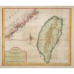
L'Isle Formose et parties des Costes de la Chine. . .
This well-known map of Taiwan was prepared by Jacques Nicolas Bellin and was based on Jesuit information. The text along the island's east coast claims: Of this coast, li...
Date: Paris, 1763

Die Insel Formosa neu abgemessen auf Befehl Kaysers Kamhi.
One of the earliest obtainable printed maps of Taiwan or Formosa Island. It was issued around 1726 to illustrate Joseph Stöcklein's [Stoecklein] compilation of Jesuit mis...
Date: Augsburg, 1726
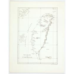
The island of Formosa.
A small, but historically important map of Taiwan (the first American lithograph of Taiwan) made by the American Commodore Matthew C. Perry and published by Ackerman. The...
Date: New York, 1856
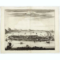
La Ville et le Château de Zélandia dans l' île de Tayovan.
This important copperplate engraving is one of the earliest European views of Taiwan, depicting the Dutch fortifications and trading settlement on the West coast of the i...
Date: Amsterdam, 1675
![Province de Fo-Kien. [Includes West Coast of Taiwan]](/uploads/cache/43503-250x250.jpg)
Province de Fo-Kien. [Includes West Coast of Taiwan]
An important map of Fujian Province shows the East Coast of China and the West Coast of Taiwan. It shows that for the Manchu Qing, only the western half of Formosa was co...
Date: The Hague, H. Scheurleer, 1737
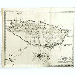
Kaart van het Eyland Formosa en de Eylanden van Piscadores.
The earliest printed map of Taiwan or Formosa. Oriented to the east, with north at the left, covering the entire island and the nearby Pescadores, now known as the Penghu...
Date: Amsterdam, 1724

Fokien Imperii Sinarum Provincia undecima.
The province of Fokien lies opposite Taiwan and south of the region described in the above map. The coast is shown from Wen-zhou in the north to Fu-zhou and as far south ...
Date: Amsterdam, 1660
![ATLAS RUSSICUS mappa una generali et undeviginti specialibus vastissimum Imperium Russicum cum adiacentibus regionibus [repeated in French].](/uploads/cache/27877-250x250.jpg)
ATLAS RUSSICUS mappa una generali et undeviginti specialibus vastissimum Imperium Russicum cum adiacentibus regionibus [repeated in French].
1745 AKADEMIE VON WISSENSCHAFTEN - The first complete printed atlas of Russia, illustrated with 22 regional maps and a folding general map (on 2 sheets). In stunning ori...
Date: St Peterburg, Akademie von Wissenschaften. 1745
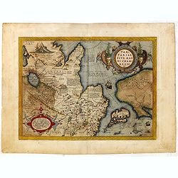
Tartariae sive Magni Chami Imperium.
This is a very early depiction of the northern Pacific, with the first mapping of the Northwest Coast of America and probably the first map to name California 'C. Califor...
Date: Antwerp, c. 1590

Tartariae sive Magni Chami Imperium.
This is a very early depiction of the northern Pacific, with the first mapping of Northwest Coast of America and probably the first map to name California 'C. Califormio...
Date: Antwerp, c. 1608-1612
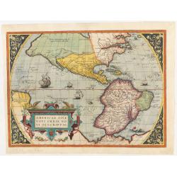
Americae Sive Novi Orbis, Nova Descriptio.
This is the second state of the first copperplate of Ortelius' map showing the western hemisphere, showing the prominent bulge in the South American coastline. The first,...
Date: Antwerp, 1573
![[ Pictorial world map ]](/uploads/cache/44376-250x250.jpg)
[ Pictorial world map ]
1951 LIOZU, J. - A pictorial world map, drawn by Jacques Liozu, including a decorative title cartouche and a compass rose.
Date: Paris, 1951
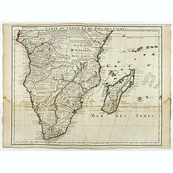
Carte du Congo et du Pays des Cafres.
Large map of the Southern part of Africa, including Madagascar. With the imprint "Chez l’Auteur sur le Quai de l’Horloge (imprint erased after Horloge) avec Privilèg...
Date: Paris, January 1708
Der Hafen und die Bai von Nagasaki.
A bird's-eye view showing Deshima and Nagasaki Bay with Dutch ships and two Dutch flags on Deshima.
Date: Germany, 1850
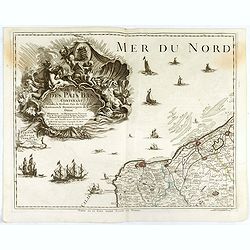
Carte des Pais Bas contenant la Flandre, le Brabant, Pais de Liege. . .
Map sheet from a multi-sheet map of the Low Countries, showing a large title cartouche and part of the Northern French coastline around Calais, Dunkirk, and Furnes. The C...
Date: Paris, 1742
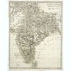
Charte von Ostindien disseits des Ganges im gegenwärtigen Zustande.
A uncommon issue of this detailed map of India, including Ceylon.
Date: Weimar, 1807
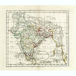
Indoustan ou Inde.
Map of India. The map is based on the Paris Meridian. Only in 1884, at the International Meridian Conference in Washington, D.C., was the Greenwich Meridian accepted.Engr...
Date: Paris, c. 1810
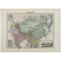
Inde, Chine, Indo-Chine et Japon.
A decorative map of India, China, Japan and East Asia from Géographie Universelle, Atlas Migeon, published by J. Migeon. In lower right corner a view of Calcutta and to t...
Date: Paris, 1874
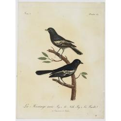
La Mésange noir. Fig.1 Le Mâle. Fig.2. La Femelle. Planche 137.
Very decorative plate from Histoire naturelle des oiseaux d'Afrique , published by Delachaussée. Levaillant's interest in natural history led him to explore Africa as the...
Date: Paris, 1796-1808
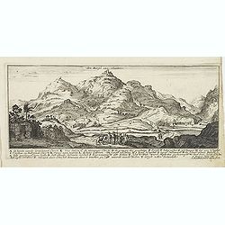
Den Bergh van olmeten. (Mount of Olives).
Magnificent view of the Mount of Olives, with the Church of the Ascension. Etched by Gaspar Bouttats (1640-1695).The Antwerp based publisher Jacques Peeters published ca....
Date: Antwerp, c.1690
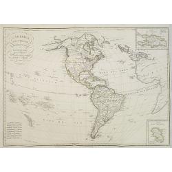
L'America Settentrionale e Meridionale . . .
Map depicting the Americas with two inset maps of the Dominican Republic and Martinique.From Giulio Ferrario's work Le Costume Ancien et Moderne ou Histoire du gouverneme...
Date: Milan, 1827
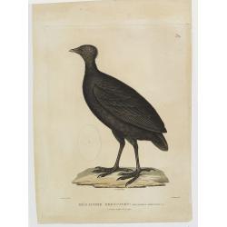
Mégapode Freycinet. (32.)
Bird print taken from "Voyage autour du Monde... Zoologie" by Jean R.C. Quoy and Joseph P. Gaimard. The plate is engraved by Coutant after a design by A.Prévost...
Date: Paris, Langlois, 1824
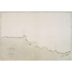
Carte de la Mer Noire. (5e Feuille). Du Cap Zefiros au Cap Kerempeh. . .
Very detailed chart of the Turkish part of the Black Sea including the towns of Sinop, Samsun, etc. Showing soundings in meters, lighthouses are marked with yellow and re...
Date: Paris, 1860
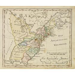
Die Vereinigten Staaten von Nord-Amerika.
Nice little German map of the early United States. The only state shown west of the Appalachian Mountains is Kentucky. Above which is a strangely shaped unnamed region (O...
Date: Augsburg, 1812
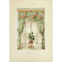
Baie Louis XVI. . .
Very decorative and colorful lithography of an elegant French interior. From La Tenture Française published by G.Mathière, 32/34 Rue de Charonne, Paris.
Date: Paris, 1882
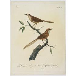
Le Capolier. Fig. 1 Le Mâle. La Queue Gazée Fif. 2. Planche 130.
Very decorative plate from Histoire naturelle des oiseaux d'Afrique , published by Delachaussée. Levaillant's interest in natural history led him to explore Africa as the...
Date: Paris, 1796-1808
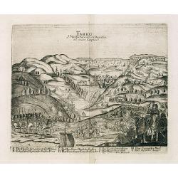
Tarku Urbs Tartaroum in Dagestan ad mare Caspium.
An early view of Tarku, in the Republic of Dagestan. From "Voyages en Moscovie, Tartarie et Perse, par Adam Olearius".Adam Olearius was a seventeenth-century G...
Date: Paris, Abraham de Wicquefort , 1656
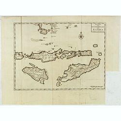
Kaart van de Zuyd-Wester Eylanden van Banda.
Early and detailed map of the Banda Islands, prepared by François Valentijn (1666–1727), a Dutch missionary who spent years in Amboina and traveled extensively through VO...
Date: Amsterdam, 1726
![[Lake George and the village of Caldwell.]](/uploads/cache/26087-250x250.jpg)
[Lake George and the village of Caldwell.]
A proof state without the text of Lake George and the village of Caldwell after Jacques Milbert, and lithographed by Sabartier.From Amérique Septentrionale. Printed by He...
Date: Paris, 1829
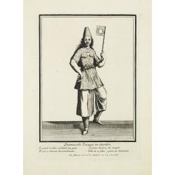
Damoiselle Turcque en chambre. . .
Beautiful engraving by Henri Bonnart (1642?-1711) vis-à-vis les Mathurins au Coq. Printed with the privilege of the King.
Date: Paris, 1690
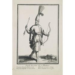
Garde du corps de sa Hautesse. . .
Beautiful engraving by Henri Bonnart (1642?-1711) vis-à-vis les Mathurins au Coq. Printed with the privilege of the King.
Date: Paris, c. 1690
