Ptolemy to Waldseemüller
Ancient mapping - Ptolemy to Waldseemüller
It is more than 500 years ago that Ptolemy's 'Geography' edited by Martin Waldseemüller was published.
Below is a summary of Ancient cartography and a fine listing of maps from the famous 1513 atlas by Waldseemüller, among other Ptolemaic maps from the 1522 edition.
Ancient mapping.
The earliest direct mapping evidence comes from the Middle East (1000 B.C.). These ancient Babylonian clay tablets depict the earth as a flat circular disk. In ancient times, Chinese cartography was more advanced than their contemporaries. Their maps were accurate and detailed compared to other ancient maps.
The Greeks (200 B.C.) understood that the earth was a sphere. Eratosthenes accurately calculated the circumference of the earth using angle measures.
The ancient Greeks made great progress in mapping. Herodotus produced a map of the world that stretched from Gibraltar to
India; Permenides (450 BC) developed a system of latitude and longitude for locating places. The Romans were also interested in map-making. They had their whole empire surveyed and had a 21-foot map showing roads, towns, rivers, and province boundaries.
With the disintegration of the Roman Empire, the art of map-making came to a standstill until Al-Idrisi, a 12th-century Arab geographer, compiled one of the greatest medieval works of descriptive geography with a 70-section map of the world for the King of Sicily in 1154.
Ptolemy.
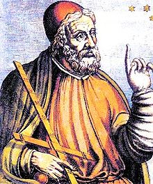 Claudius Ptolemy (87-150) was an Egyptian astronomer and geographer living and studying in Alexandria.
Alexandria was not only the home of the greatest library of any period, but was also one of the most important trade centers between west and east - here Ptolemy could not only study ancient authorities but could also consult contemporary travelers and merchants.
Claudius Ptolemy (87-150) was an Egyptian astronomer and geographer living and studying in Alexandria.
Alexandria was not only the home of the greatest library of any period, but was also one of the most important trade centers between west and east - here Ptolemy could not only study ancient authorities but could also consult contemporary travelers and merchants.
From this wealth of accumulated knowledge, Ptolemy composed his "Geographia", a work of considerable genius,
which dominated the whole of the Christian and Moslem world for 1,500 years (Tooley).
Ptolemy (150 A.D.) defined in Geography the elements and form of scientific cartography. Despite his errors (he maintained that the sun revolved around the earth and calculated the earth as 3/4 its actual size), Ptolemy was far ahead of his time on how scientific research should be conducted. He proposed a system of projections and coordinate systems that are still used today.
Had Ptolemy taken the value of the circumference of the Earth worked out by Eratosthenes then his coordinates would have been very accurate. However, he used the later value computed by Posidonius around 100 BC, which, although computer using the correct mathematical theory, is highly inaccurate.
Therefore instead of the Mediterranean covering 42° as it should, it covers 62° in Ptolemy's coordinates.
Books 2 to 7 of Geography contain the coordinates of about 8,000 places. Still, although he knew the correct mathematical theory to compute such coordinates accurately from astronomical observations, there were only a handful of places for which such information existed. It is not surprising that the maps given by Ptolemy were entirely inaccurate in many places, for he could not be expected to do more than use the available data and, for anything outside the Roman Empire, this was of inferior quality with even some parts of the Roman Empire severely distorted.
Geographia.
Ptolemy used data from most of his predecessors, particularly Marinus of Tyre. He used information from reports of travelers who gave such information as "after ten days travel north we reached ...". To estimate distances from such data, Ptolemy had to assess the difficulty of the terrain, how straight the route the travelers took had been, and many other unknowns. Given the way that he gathered the data, it is certainly not surprising that the maps were inaccurate, but they represented a considerable advance on all previous maps, and it would be many centuries before more accurate world maps would be drawn.
Although the cartographic content of the Ptolemaic atlases and maps was standard, specific editions are worthy of comment:
- 1477- the first edition with maps. Copper engravings.
- 1482- Ulm Ptolemy. The first edition was printed north of the Alps, with four modern maps added. Printed from woodblocks.
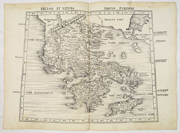
- 1513 - Published by Martin Waldseemuller, incorporating 20 new maps, including the second map to focus on the discoveries of the New World. Woodblocks.
- 1522 - Illustrated with woodblocks cut by Laurent Fries, careful reductions of Waldseemuller’s maps.
- 1540 - Sebastian Munster’s issue of Ptolemy’s maps; subsequently re-issued in various books of classical geography - attractive woodblocks.
- 1548- The first Italian text edition, the first miniature edition in copperplate of Ptolemy’s Geography, including several new maps by Gastaldi.
- 1561 - Gastaldi’s maps re-issued, in a slightly larger format, by Ruscelli and Valgrisi in Venice.
- 1578 - the first issue of Mercator’s version of Ptolemy’s maps - intended as a companion to his Atlas of the Modern World. Numerous re-issues. For the 1698 edition, the plates were re-worked, substituting a new cartouche within the map, containing a second title.
Roman times
Little progress was made in cartography over the following centuries. The fact that the Romans made few contributions is slightly strange given their road-building skills, which required accurate surveying measurements. Also, their commanders' exact military strategies would seem to motivate them to create maps to help their military campaigns. Perhaps it was the mathematical nature of a map that prevented the non-mathematical Romans from advancing the subject. In China, however, there is evidence that mathematics had been used an a major way in surveying and cartography. In Liu Hui's 3rd century work the Sea Island mathematical manual is studied. The book gives a good insight into the history of surveying in China and its links with cartography. The main driving force in China to survey and draw maps was often for military reasons but also for problems such as water conservation.
Christianity Once Christianity spread across Europe, those of learning were Churchmen, and they argued that the truth about the world was contained in the Bible and not to be found by scientific investigation. Where Bible quotations appeared to contradict pre-Christian scientific discoveries, then good science was dismissed as pagan foolishness. Biblical quotations convinced some that the Earth was a circle, certainly not a sphere, while for others, quotations such as "the four corners of the Earth" in Isaiah proved that the Earth was rectangular.
Arabic/Persian/Muslim world
In the Arabic/Persian/Muslim world, progress was made in cartography, however, and far more progress than was realized for a long time, for it is only in recent years that the full significance of these contributions has been realized.
Ptolemy's Geography was translated into Arabic in the 9th century, and improvements were soon made using data obtained
from the explorations being carried out. Al-Khwarizmi wrote a major work on cartography which gave the latitudes and longitudes for 2402 localities as a basis for his world map.
The book, which was based on Ptolemy's Geography, lists latitudes and longitudes, cities, mountains, seas, islands, geographical regions, and rivers. The manuscript does include maps that are more accurate than those of Ptolemy, in particular, it is clear that where more local knowledge was available to al-Khwarizmi, such as in the regions of Islam, Africa and the Far East then his work is considerably more accurate than that of Ptolemy, but for Europe al-Khwarizmi seems, on the whole, to have used Ptolemy's data.
The major work by Sezgin, has done much to demonstrate that medieval Islamic geographers had an essential influence on the development of geography in Europe up to 1800. In he presents a reconstruction of al-Khwarizmi's map of the world which he believes used a stereographic projection of the terrestrial hemisphere, with a pole on the terrestrial equator. Sezgin also argues that Ptolemy's Geography may not have included a world map and that some later world maps are based, at least in part,
on Islamic sources.
The following important Islamic scholar we should mention is al-Biruni, who wrote his Cartography in around 995. In it he discussed map projections due to other scientists, then gives his own interesting mapping of a hemisphere onto a plane.
A detailed description of this projection is given in [17]. Al-Biruni wrote a textbook on the general solution of spherical triangles around 1000 then, sometime after 1010, he applied these methods on spherical triangles to geographical problems.
He introduced techniques to measure the Earth and distances on it using triangulation. He computed very accurate values for the differences in longitude and latitude between Ghazni in Afghanistan and Mecca. He found the earth's radius to be 6339.6 km, a value not obtained in the West until the 16th century. His Masudic canon contains a table giving the coordinates of six hundred places, some of which were measured by al-Biruni himself, some being taken al-Khwarizmi's work referred to above.
At a time when Christian Europe was producing religious representations of the world rather than scientific maps, another type of map, or perhaps more accurately, chart, for the use of sailors began to appear. These were called portolan maps (from the Italian word for a sailing manual) and were produced by sailors using a magnetic compass. The earliest examples we know about the date from the beginning of the 14th century and were Italian or Catalan portolan maps. The earliest portolan maps covered the Mediterranean and the Black Sea and showed wind directions and useful information to sailors. The coastlines shown on these maps are by far the most accurate to have been produced up to that time. The Catalan World Map, produced in
1375 was the work of Abraham Cresques from Palma in Majorca. He was a skilled cartographer and instrument maker and the map was commissioned by Charles V of France. The western part of his map was partly based on portolan maps, while the eastern part was based on Ptolemy's data.
Martin Waldseemüller.
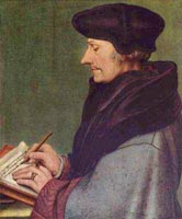 Waldseemüller was born some time in the 1470's in Radolfzell, Württemberg, in Germany. He began his education at the University of
Freiburg in 1490. In 1507, he moved to Saint-Dié in Lorraine, France. Here, according to Hébert, Waldseemüller became a member of a small intellectual circle called Gymnasium Vosagense. He died in France in 1522.
Waldseemüller was born some time in the 1470's in Radolfzell, Württemberg, in Germany. He began his education at the University of
Freiburg in 1490. In 1507, he moved to Saint-Dié in Lorraine, France. Here, according to Hébert, Waldseemüller became a member of a small intellectual circle called Gymnasium Vosagense. He died in France in 1522.
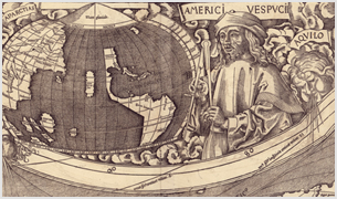 He was the author of the wall map of 1507, which named America for the first time. In that same year, it is believed he completed the maps for an edition of Ptolemy's 'Geography'. It was not until 1513, though, that it was published.
Martin Waldseemüller, a highly accomplished scholar of geography, merged the science of mapmaking and the art of printing in this
1513 atlas, one of the most groundbreaking documents in the history of cartography.
He intended this atlas as a new edition of Ptolemy's Geographia. In the group of Ptolemaic atlases, this one is very important because it incorporates 20 modern maps that were not based upon the tradition of Ptolemy. Waldseemüller's use of a quadratic plane projection was also a noteworthy advance.
Johannes Schott was the printer, and Martin Waldseemülller did the drawings. The editors of the text were Jacobus
Aeschler and Goeorge Uebel.
The text itself was a revision by Mathias Ringmann based on d'Angelo's translation
from ancient Greek conflated with another text by Picus della Mirandola.
Rene Duke of Lorraine, an art and science patron of the Renaissance period, made it possible for Waldseemüller to draw new maps and copy those of Ptolemy.
Waldseemueller abandoned Ptolemy's projection to favor one based on rectilinear meridians and parallels.
Although these newly drawn maps were completed in 1507, Waldseemüller's patron died in 1508, and it was not until 1512 the work could be printed.
In addition to the twenty-six classical Ptolemaic maps, this atlas was accompanied by a supplement of twenty new maps that were published as a separate volume.
In a forward written by Äschler and Übel, we are told that the map of the New World was drawn according to the newest and most reliable information, the source of which is identified as "The Admiral".
Researchers today believe that "The Admiral" is Columbus and for that reason, call this atlas the "Admiral Atlas".
This atlas was printed using the same woodcut maps but with a few minor text corrections on the Schott press in Augsburg, with Übel acting as editor.
Most maps have a watermark of a triple-pointed crown.
Laurens Fries.
Lorenz (Laurent) Fries was born in Alsace in 1490 or thereabouts, describing himself on one occasion as from Colmar. He studied medicine at university, or rather at universities, as he seems to have had a peripatetic education, apparently spending time at the universities of Pavia, Piacenza, Montpellier and Vienna.
Having completed his education, Fries established himself as a physician at a succession of places in the Alsace region and finally settled in Strasbourg in about 1519.
By this time Fries met the Strasbourg printer and publisher Johann Grüninger, an associate of the St. Die group of scholars formed by, among others, Walter Lud, Martin Ringmann and Martin Waldseemuller. Grüninger.
The major project that Fries and Gruninger worked on was a new edition of the Geographia of Claudius Ptolemy, published by Johann Koberger in 1522. Here again, Fries evidently edited the maps, in most cases simply producing a reduction of the equivalent map from the 1513 edition of the Geographie Opus Novissima, printed by Johann Schott.
Fries also prepared three new maps for the Geographie: maps of South-East Asia and the East Indies, China and the
World, but the geography of these derives from Waldseemuller's world map of 1507.
Lorenz (Laurent) Fries was born in Alsace in c1490. He studied medicine at university and established himself as a physician in France before settling in Strasbourg in about 1519. There, Fries met the printer and publisher Johann Grüninger, an associate of the St. Die group of scholars formed by, among others, Martin Waldseemüller.
For the next five years, from about 1520 to about 1525, Fries worked in some capacity as a cartographic editor for or with Grüninger, exploiting the material that Waldseemüller had created from Ptolemy. Unfortunately, there is little evidence to help gauge the exact nature of the relationship.
Fries' first venture into mapmaking was in 1520, for that is the date found on a map of the World bearing his monogram. The map was a reduction of
Waldseemüller's wall map of the World, published in 1507. The major project that Fries and Grüninger worked on was a new edition of the Geographia of Ptolemy, which was first published in 1522. Fries evidently edited the maps, in most cases simply producing a reduction of the equivalent map from the 1513 edition of the Geographie Opus Novissima. Fries also prepared three new maps for the Geographia: maps of Southeast Asia and the East Indies, China, and the World, but the geography of these derives from Waldseemüller's world map of 1507.
In 1525, Fries was forced to move on as he had exhausted the existing body of Waldseemüller's works. For whatever reason, his departure marked the end of his cartographic work, and he again turned to writing medical textbooks, which occupied him until he died in 1531 or 1532. The 1535 and 1541 editions of Fries’ Geographia are printed posthumously.
Karrow noted "Grüninger had high hopes for this edition, one of the grandest products of his press in a period when it was not known for producing grand books. However, The edition suffered from many textual errors ...
Nevertheless, the book sold well enough to justify a new edition three years later..."
Instead, it would appear that Grüninger sought to recoup his investment by preparing an improved edition. To this end, he sought the assistance of Wilibald Pirkheimer to re-edit the text using the notes of Johannes Regiomontanus.
The new edition was ready in 1525. As Karrow notes, the press work was not of a high standard, and Pirckheimer was generally dissatisfied with the finished book.
After Grüninger's death in 1531, the business was continued by his son Christoph, who seems to have sold the materials for the Ptolemy to two Lyons publishers, the brothers Melchior and Gaspar Trechsel, who published a joint edition in 1535, before Gaspar Trechsel published an edition in his own right in 1541.
Servetus and Calvin.
These two editions were edited by Michael Servetus (or Villanovus), a Spanish doctor resident in Lyons.
In those difficult times, Servetus was accused of heresy. One piece of evidence used against him was a passage on the reverse of the modern map of the Holy Land, which said that "Palestine was not such a fertile land as was generally believed since modern travelers reported it barren". Unfortunately, this not Servetus' original view but was a passage repeated from the 1522 edition.
This charge seems to have counted against Servetus, for when he was burnt at stake, Calvin ordered that copies of the book be burnt with him.
Fortunately, Calvinist authorities may only have burnt a few token copies!