Nansenbushu bankoku shoka no zu.
 Publisher : ZUDA ROKASHI [Priest Hotan]
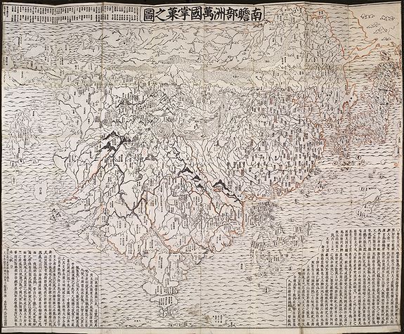
Title: Nansenbushu Bankoku Shoka No Zu [Outline Map of All Countries of the Universe]
Published in Kyoto, 1710 (Hoei 7 = Year of the Tiger) by Bundaiken Uhei (fl. 1680-1720), a Japanese bookseller
and publisher active in Kyoto during the early part of the 18th century and best known for his publication of this important Buddhist world map.
Size : 45.1 x 55.7 inches. / 114.5 x 141.5 cm.
Coloring: Contemporary outline coloring, with North, East, South, and West directions added in red ink.
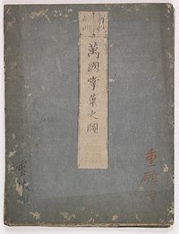
Condition: Strong impression, printed on several sheets of native paper, joined. Folded as usual and mounted on 2 blue cardboards with title-piece. (size 240 x 180mm, slightly spotted and scraped) in a modern linen case. The map in very good to mint condition.
Price : $ 20,000
This map is a great example of Japanese world maps representing Buddhist cosmology with real-world
cartography. It is the earliest one and - therefore - the prototype for Buddhist world maps.
The map centered on 'Jambu-Dvipa', the mythological heart of Buddhist cosmography where Buddha was born in Northern India with the sacred lake of Anavatapta, and the four sacred rivers Ganges, Oxus, Indus, and Tarim flowing from it, the map extending from Ceylon to Siberia, and from Japan to the British Isles 'Country of the Western Woman', with Europe as a group of islands, Africa figured as
a small island, and a land bridge connecting China with an unnamed continent to the East [America?], numerous place names; texts placed in the lower-left and lower-right corners, including a list of Sutras and Chinese histories; and a title in a banner at the upper margin.
At the time, Japan maintained an isolationist policy that began in 1603 with the Edo period under the military ruler Tokugawa Ieyasu and lasted for almost 270 years. Although Matteo Ricci's world map, published in Peking in 1602, was known, Japanese maps mainly showed a purely Sino-centric view or, with acknowledgment of Buddhist traditional teaching, the Buddhist habitable world with an identifiable Indian subcontinent.
The map was drawn by the scholar-priest Zuda Rokashi (1654-1728), (or Hotan his religious name), the founder of Kegonji Temple in Kyoto, and illustrates the fusion of existing Buddhist and poorly known European cartography.
The language is Chinese, except for a few Japanese characters on the illustrations of European countries.
South of Jambu-Dvipa, India is recognizable for in its peninsular form. Japan appears as a series of islands in the upper right and, like India, is one of the few recognizable elements, at least from a cartographic perspective. China and Korea appear to the west of
Japan and are vaguely identifiable geographically, which itself represents a significant advancement over the Gotenjikuzu map. Southeast Asia also makes one of its first appearances in a Japanese Buddhist map as an island cluster to the east of India.
Europe, which had no place at all in earlier Buddhist world maps, making this one of the first Japanese maps to depict Europe, is shown at upper left as a group of islands, which can be identified from Iceland to England, Scandinavia, Poland, Hungary and Turkey, but deliberately deleting the Iberian Peninsula. Umukari [Hungary], Oranda, Baratan, Komo [Holland or “the country of the red
hair”], Arubaniya [Albania?], Itarya [Italy], Suransa [France], and Inkeresu [England] are also named. Africa appears as a small island in the western sea identified as the “Land of Western Women.”
In the lower right, South America appears as an island south of Japan, with a small peninsula as part of Central America, carrying only a few place-names, including four Chinese characters whose phonetic Japanese reading is “A-ME-RI-KA”. North
of Japan, a land bridge joins Asia with an unnamed landmass, presumably North America. Africa is not shown at all. On the other hand, this map is much more than a world map, and the main concept by the author was to celebrate a historically very important event.
The map echoes the pilgrimage route of the famous Chinese Buddhist priest Hsuan-Tsang (or Xuanzang, Genjo in Japanese; 602-664 A.D.), who traveled to India to visit sacred Buddhist sites and collect holy Sanskrit texts.
So the largest part of the map is depicted to "Jambu-Dvipa" with the sacred Lake of Anavatapta (Lake Manasarovar in the Himalayas) at its center, from which the 4 rivers Ganges, Oxus, Indus and Tarim are flowing. This all was based on the Japanese
version of Hsuan-Tsang's Chinese narrative, the Si-yu-ki, printed as late as 1653. It gives numerous details, including the so-called "iron-gate", shown as a strongly oversized square, and the path the monk took while crossing the forbidden mountain systems after leaving Samarkand.
Also, in the upper left corner, 102 references from Buddhist holy writings and Chinese annals are listed to increase the map's credibility.
The first Buddhist world map printed in Japan and the prototype for all subsequent Buddhist world maps printed in Japan until the late nineteenth century. The author, Hotan (1654-1728), was a scholar-priest and founder of the Kegonji Temple in Kyoto. The earliest known example in Japan is the Gotenjiku Zu (Map of the Five Indies) by the priest Jukai dating from 1364, and now preserved in Horyuji Temple in Nara. However, Hotan’s map was revolutionary in being the first printed
Oriental map to introduce detailed Western cartographic information into this traditional Buddhist cosmological view and to attempt to merge the two together into a comprehensible form. Europe is depicted as a series of islands in the upper left of the image, while South America is likewise shown as an island in the lower right. Africa is omitted completely.
China and Japan are clearly defined in the upper right of the map. The map's popularity is evident in the fact that, although it dates to 1710, it was reissued unchanged in numerous editions through about 1815 and spawned innumerable copies and derivatives over the next 150 years. A rare and important cartographic work.
The map is based on the pilgrimage route of the famous Chinese priest Hsuang-Tsang (602-604) who traveled to India in the 7th century to collect holy Sanskrit writings. The first printed Japanese version of the Chinese narrative of the Si-yu-ki appeared in 1653 and was a major incentive for publishing this map, which was used for Buddhist propaganda and education.
Two identical versions of this woodblock map appeared in 1710. The more common version was published by Kyoto bookseller Chobei Nagata. A less common example was published by the bookseller Bundaiken Uhei and corresponds to this example. Bundaiken Uhei’s mark and name appear in the lower left quadrant. In most examples, coloration varies. A strong, crisp image suggests this is one of the first examples Bundaiken Uhei printed, as wooden plates tend to wear quickly and many other examples show signs that the woodblock was more heavily worn.
References :
- K Yamashita, Japanese Maps of the Edo Period, pp.32-33 ill.
- Nanba, Old Maps in Japan ,ill. 8.
- K.Unno, Cartography in Japan, 1994, page. 346-477 and illustration 11.59.
- Cortazzi, Isle of Gold ,page 38 and ol.ill. 48.
- Beans Coll. 1710.1.
- Kerlen 44,
- Muroga & Unno, “The Buddhist World Map in Japan”, in IM XVI (1962).
- Harley & Woodward, The History of Cartography, 2.2, pp.428ff and ill.. 11.59.
- Shintaro Ayusawa, (1954), "The type of world map made in Japan's age of isolation",
- Imago Mundi, v. 10, pp. 123-127, and M. Ramming, (1954), "Remarks to reproduced Japanese
maps", Imago Mundi, v.10, p. 128. The map reproduced as Fig. 2, facing p. 124. Map is described as " ...
prototype of Buddhist world maps." (p.124) "... whose main distinctive feature is their completely
unscientific character." (p. 128).
