Mapping of Russia
From then on, the Russian Empire had a Tsar or Tsarina (zahr-ee-nah) who ruled as an absolute monarch. By the end of the 1800s, the Russian Empire was vast, spanning nearly one-sixth of the Earth's landmass.
The Russian Empire ended in 1917 with the abdication and subsequent murder of Tsar Nicholas II following the Russian Revolution.
This development is evident in old maps.
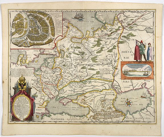
The first modern map of Russia.
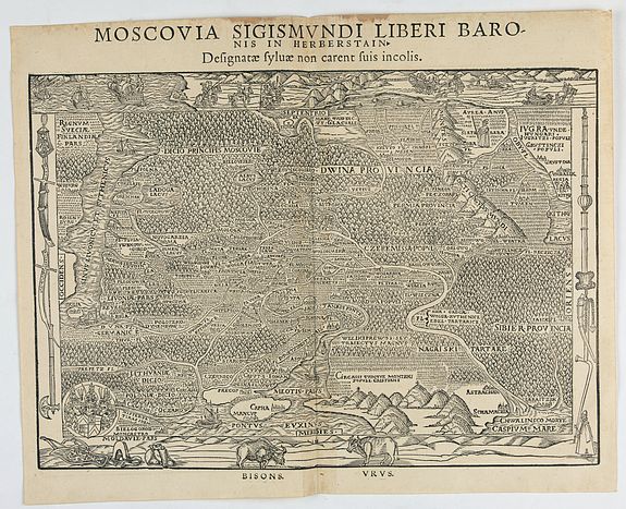
Moscovia Sigismundi Liberi Baronis In Herberstein, Neiperg et Gutehnag Anno M.D XLIX. (Vienna, 1549)
Sigismund von Herberstein made two visits to Russia. Between 1517 and 1518, he traveled as a diplomatic envoy of the Holy Roman Emperor, Maximilian I. He returned in 1526-1527 as an ambassador of Ferdinand I, King of Bohemia and Hungary.
His combined visits amounted to a period of sixteen months during which he was able to see "... the land and city of Moscow and much of their manners and customs... Thus I can bear witness not merely from hearsay but as one who has seen partly for himself..." (Translation by J B C Grundy: 1969, p15)
He attempted to procure maps, but as these, besides being very scarce, were kept strictly secret by the authorities, he tried to persuade those whose knowledge he could trust to prepare maps for him. According to Lyatsky, who, however, made this statement after having left Russia, he had asked him to compile a map, but met with a refusal. Herberstein does not tell us whether he succeeded in obtaining cartographic materials from any other person. However, he indeed obtained a great deal of oral information and some graphic material as well.
ATLAS RUSSICUS mappa una generali et undeviginti specialibus vastissimum
Imperium Russicum cum adiacentibus regionibus [repeated in French]. - St Peterburg, Akademie von Wissenschaften. 1745.
The first complete printed atlas of Russia. Jacques Nicolas Delisle, brother of Guillaume Delisle, was invited by
Peter the Great to survey the vast empire of Imperial Russia. Initially accompanied by his step-brother Louis, in 1726, the two Parisians journeyed to Russia (now under the reign of Catherine I) to start their surveys.
At first, Delisle also worked with Ivan Kirilov, who co-founded the St Petersburg Academy of Sciences. However, the two men did not always see eye to eye, and Kirilov went on to produce an incomplete atlas which was published in 1734, before the French team had finished their surveys. Kirilov died in 1737, eight years before the eventual publication of Delisle's atlas.
The Atlas Russicus is effectively in two parts: the first covers European Russia in 13 numbered maps (scale 1; 1.527.000), and the second covers Siberia in six maps. Scale (1: 3.360.000). On map 19 "Ostium fluvii Amur " the extreme point of Alaska and the Aleutian islands.
The Russian Academy of Sciences.
The Russian Academy of Sciences was created in 1724 in St Petersburg. It was not only intended to coordinate and produce science, but also to aid in solutions to practical problems. Many foreign scientists were invited to participate.Joseph Nicolas Delisle was invited to head the Department of Geography, and he duly arrived in 1726.
The making of the first atlas Russicus, not surprisingly considering the size of the country, took a long time. New bearings in trigonometry had to be taken all over the country. Existing cartographic material had to be obtained and analyzed. Upon his return to Paris in 1747, Delisle was able to construct his own observatory in the Palace of Cluny, the same observatory later made famous by the French astronomer Charles Messier.
Among the Russian scientists who worked on the atlas was Kirilow, the man who published the first map of Russia in 1734.
The best-known expedition that fed data into the Atlas Russicus was the Great Northern Expedition (1735-1743). Gmelin, Muller, Krshnininnikow, Krasilnikow and Steller were among its participants.
Except for reliable data printing facilities, which were needed. The Academy's engraving shop was set up in 1728 with staff as Ellinger, Unversagt, Zubov, and Rostovtsev. Eventually, in September 1745, the atlas was printed in St Peterburg in Russian, Latin, and German.
"Send out to various governments.. the atlas met with great praise everywhere" (Bagrow).
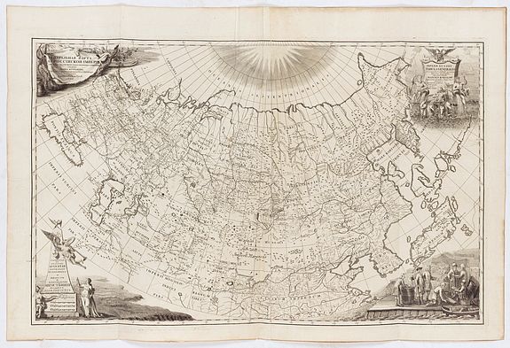
This is the first general map of the state to be created in Russia on a scientific basis,
A cartouche with the title contains a fragment of the procession of Neptune, allegorical images of rivers, a two-headed eagle with a broadsword and a cross, and an armillary sphere. The figure on the lower right side shows the trade scene with the aborigines. In the background, fishing tackle and fish are displayed.
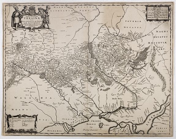
The mapping of Ukrainian lands
(whose greater part entered the structure of the Polish-Lithuanian Commonwealth). The creation of a four-sheet map of the Grand Duchy of Lithuania by Nikołaj Krzysztof Radziwił in 1613 essentially influenced the 17th century.
The main plotter of the map was cartographer Tomash Makovsky.
The map covers a substantial area of Ukraine. Dnepr is represented on an additional inset map on a larger scale; later, this inset map was issued as a separate map. The creation of the map of the Grand Duchy of Lithuania became a significant achievement in the 17th century. Its re-edition of 1631, which was included in Willem Blaeu's atlas, is well-known.
The territory of Ukraine is also represented on the maps of Russia published in the 16th – 18th centuries by famous publishers as P. Schenk II, G. Delile, S. von Herberstein, G. Mercator, I. Massa, J. Blaeu, N. Vischer II, M. Merian etc.
