Complete Map of the Capital, the Provinces and Famous Sites in China
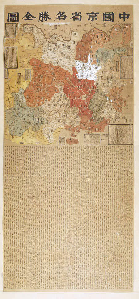
(中國京省名勝全圖, Zhong Guo Jing Sheng Ming Sheng Quan Tu)
Author of the very extensive text accompanying the map (about 10.000 Chinese characters) (and probably artist of the woodcut illustration of the map), (left corner in the bottom of the map): Lu An Shi (呂安世)
Dated: (left corner in the bottom of the map) Kang Xi Ren Chen, (康熙壬辰); Kang Xi, year of the dragon; Kang Xi 51 = 1712; Map edited by Lu An Shi in the city of Shao Xing in Zhejiang Province
Manuscript on the side of the map: Property of Mr. Song ? (second character illegible)
State of conservation: exceptionally fine copy.
Sold
This hand-coloured, woodcut printed map, containing very extensive commentary, both of geographical and historical nature, is extremely rare. No European collection appears to house it. We do not know if it is available in the collection of the United States Congress
Library. The map is not reproduced in any of the numerous books related to Chinese maps published both in China and in the West that we have consulted:
1a. Li Xiaocong, A Descritive Catalogue of pre-1900 Chinese Maps seen in Europe, 1996
1b. Unno Kazutaka, Tōyō-Chirigakushi Kenkyū, 2004
1c. Liu Zhemwei, A selection of China's Ancient Maps, Beijing, 1995
1d. Cao Wanru et al., An Atlas of Ancient Maps in China, 3 vols., 1994-1997
1e. Zheng Xihuang, An Atlas of Ancient Maps in China, Sotheby's Publications, 1998
1f. Laura Hostetler, Qing Colonial Enterprise: Ethnography and Cartography in Early Modern China, 2001
1g. James R. Akerman, The Imperial Map: Cartography and the Mastery of Empire, 2009
The various provinces are illustrated with different colours. As usual in Chinese maps, Japan is not illustrated. One can only see the two characters: Nihon (日本).
According to a text within a rectangle on the left-side on the top of the map, each square represents 500 square Li, (1 Li = 0.5 km).
Fu (府), Zhou (州), Xian (縣) and Si (司) were local administrative units in a decreasing order in old China. Fu , a large city, is illustrated within a rectangle. The rectangles are of different decoration according to the importance and size of the cities. Zhou , a medium sized city is illustrated within an ellipse on the map. Small places (Xian and Si) are not shown. Military administrative units are shown by the character Wei (衛). Place names on the map are accompanied by the amount of food supply of the location, essentially rice and wheat.
Distances on the map are given in Li (里) and Zhang (丈); 1 Li = 0.5 km; 1 Zhang = 3.3 m.
Explanatory text about the capital and its history: During the Ming (1368-1644) and the Qing Dynasties (1644-1912) the Northern Capital, 北京 (Peking or now Beijing) was also called Shun Tian Fu (順天府). The city was the capital during the Yuan Dynasty (1279-1368) and became again the capital early in the fifteenth century after emperor Yong Le (永樂). The Southern Capital, 南京, (Nanking or now Nanjing) is given with its old name of
Jiang Ning (江寧).
The map displays in great detail the following few major geographical and historical sites:
The Yellow River (黄河), the cradle of Chinese civilization, long of about 5.000 km and its source (lake in the middle of the map on its Western extremity) Xing Xu Hai (星宿海) in the high mountains of Tibet; the famous Grand Canal (運河) connecting Hangchow and Beijing and allowing the food supply of the Northern Capital from the agriculturally more prosperous Southern Regions; the Yangzi River; the largest lake of China the Dong Ting Hu, (洞庭湖) the most important sweet-water source of the country; The Great Wall with its numerous entrance gates severely militarily guarded; in the North, the Gobbi Desert; the five holy mountains of buddhism: Heng Shan, Hua Shan, Tai Shan, Southern Heng Shan and Song Shan; the birth-place of Confucius, Qufu (曲阜) in Shandong Province. Many details of historical significance about various cities.
Partial translation of the long explanatory text below the map:
Looking at the map of “All Countries of the World” (allusion to the world-map published by
Matteo Ricci in Beijing in 1602), people might think that the world is very big and China is
only small. Of course, the world is very big, but China is not small at all. I made a new map in order to help people to study (the geography) of our country. In this map I only illustrated those cities and places which are of importance from the point of view of their geography, history, culture and food production. Those important places which are no longer extant are not shown on the map.
In the Forbidden City of Beijing the Western Garden is noteworthy. There are deep lakes with quite strange stones on its side. Inside the lake, water lily, algae, various birds as well as many types of fishes can be found. The flowers and plants in the garden are beautiful. The landscape gives the idea of what paradise might be. In addition, twenty Li South of Beijing there is the Southern Lake. That lake is very large, almost like the sea, its circumference is about 18.660 Zhang.
At a distance of about 38 Li from South-East from Changping (昌平) there is a spring. Taking bath in the spring is a good treatment against (some) diseases. By the way, there are many such springs in China. I was not able to record all of them. In Heng Shan mountain, Taixuan Spring (太玄泉) (is famous) in view of the growing of 19 different grasses (on its
slopes). Tasting those grasses people might make people immortal.
At about 30 Li South of Jiangning Fu (江寧府) there is a hilly place with a cave having a stone drum inside. The drum is known to emit a sound upon the coming rain. In Bantang Lake (半湯湖), 40 Li North-East of Jiangning Fu there is a lake containing hot-water and cold-water which do not mix. The temperature of the hot part of the lake is such that one can cook a chicken in it. Fish is abundant in both parts of the lake. However, the fish of the hot-water and the fish of the cold-water do not mix. If by mistake a hot-water fish penetrates the cold-water part of the lake, it will immediately die. The hot-water of the lake is used for field irrigation. As a consequence, two crops can be obtained every year. 70 Li South-East of the city of Li Shui (溧水) there is a “swallow hole” large enough to house several thousands of people. There is a “stone-swallow” in the hole. In case of rain, the swallow leaves the hole and begin flying. The bird returns to the hole when the weather becomes again fine. Then, the swallow changes again into a stone. Mountain Mao (茅山) is located at 45 Li South-East of the city of Ju Rong (句容). There are two springs on the mountain called Xi Ke (喜客) and Fu Zhang (撫掌). Water only springs from Xi Ke when visitors are
present. The water begin boiling from Fu Zhang when visitors clap with their hands. Duo Spring is North-East of the city of Shou Zhou (壽州). Normally, the spring does not produce any wave. Nevertheless, when visitors come to the spring and shout loudly, the spring becomes wavy. The strength of the wave depends upon the loudness of the shout. South-West of the city of Yi Xing (宜興) there is a lake on the slope of the mountain. In that lake
turtles have three feet and tortoises have six eyes.
Yang Zhou (楊州), (in present Jiangsu Province) is the most luxurious city in the world. 120 Li West of the city of Shu Cheng (舒城) Duo Zhi Mountain is located. The water in the small rivers of the mountain is very clean. Drinking that water might make people full of wisdom. Zhaobao Mountain is located 5 Li East of the city of Dinghai. Mouzi Yard is on the slope of the mountain. People can easily obtain chess pieces on the Yard. If they disperse white rice on the ground, the next day the rice changes into white chess pieces. However, if they spread about black beans, the beans are transformed into black chess pieces.
(The text continues by relating such unlikely phenomena in the tradition of world maps produced in Europe during the 16th century). However, the author of the text should be a highly knowledgeable scholar. He affords proof of acquaintance with Matteo Ricci's map, makes allusions to historical events only known to intellectuals. At one time in the text, he cites for instance Wang Mang (王莽),2 45 BC.-6 AD., without giving any detail about that official of the Han Dynasty, with the idea that those studying his map are highly educated persons and supposed to be well acquainted with fine details of Chinese history. There are many such examples in the printed text.
------------
2. Note of the translator of the map's text: Wang Mang was a Han Dynasty official who seized the throne from the Liu family and founded the Xin Dynasty, ruling AD 9 – 23. The Han Dynasty was restored after overthrowing Wang Mang. This event marks the separation between the Western Han (206 BC. - 9 AD.) and the Eastern Han Dynasty (23 AD. 220 AD.)
