Sangoku Tsuran Zusetsu (Illustrated General Survey of the Three Countries)
A banned and controversial work representing one of the earliest attempts to define Japan in terms of its outer boundaries. It represented a modern effort to distinguish Japan from the neighboring nations.
The book deals with Joseon Dynasty (Korea) and the Kingdom of Ryukyu (Okinawa), and Ezo (Hokkaido) and the Ogasawara Islands (Bonin Islands).
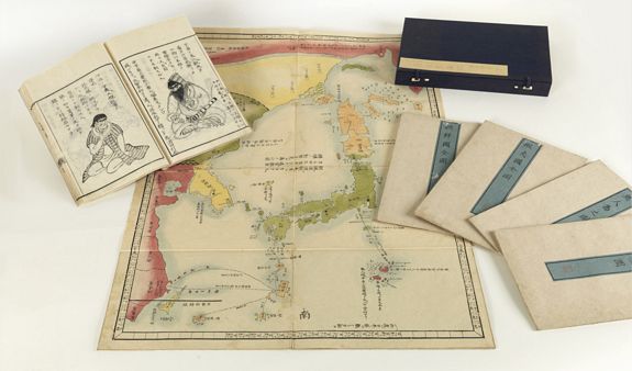
One text volume and 5 maps. The volume contains 107 pages (54 folded leaves) printed on Japanese washi paper, each leaf folded in the traditional ehon style. 32 of the pages contain wood cut illustrations. The maps with the usual worm traces, or paper thinning; expertly repaired. Generally in very good condition. Stunning original colours
Sold
.
When this work was initially published, c. 1785, the content was as controversial as it is today.
Hayashi Shihei was a samurai of the Sendai clan issued in 1785 (Tenmei 5) and he issued this book consisting of five maps and one text volume which detailed the customs of Korea, Ryukyu Kingdom, and Ezo country (Hokkaido).
Shihei, who felt the nation's crisis was due to the repeated arrivals of foreign ships, had begun writing the "Kaikoku Heidan" which discussed the defense of the coast from the year after Sangoku Tsuran Zusetsu publication. (published in 1787)
There was no publisher who undertakes the publication of this work which can be interpreted as criticism of the Tokugawa shogunate, and this book was issued at Shihei's own account in 1787-1791.
The following year, the Tokugawa shogunate evaluated the content of this book as a delusion, banned it in 1792 = Kansei 4, and decided the home arrest of Shihei further. Sangoku Tsuran Zusetsu also became a collateral victim of this banning and the woodblocks of two books were seized; almost all the original woodblock printed versions of Sangoku Tsuran Zusetsu were collected and destroyed. Nonetheless, Shihei's work survived and manuscript copies of his maps began to circulate in learned Japanese circles. Today, few examples of Shihei's book are recorded.
Ironically, shortly after he was punished, a Russian ship arrived in Nemuro, and the shogunate was forced to take measures to protect the coast.
However, this book went from Nagasaki to Holland and Germany through Katsuragawa Honshu (was a doctor and Edan scholar in Edo) later and was translated into European languages in Russia. In 1872, it was translated into French by the German Oriental scholar Heinrich Klaproth.)
 Dokdo
Dokdo
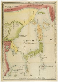
The most controversial map in the book is the map Sangoku tsuran yochi rotei zenzu. (Illustrated General Route Map of the Three Countries.) The three countries, in this case, refer to the three nations bordering Japan: Yezo (Hokkaido), Korea, and the Ryukyu Kingdom (Okinawa). In modern terms, it covers from the Sea of Okhotsk and the southern tip of Kamchatka south as far as Taiwan and the Ogasawara Islands, including the modern-day countries of Japan and Korea, as well as parts of China and Russia.
Shihei's map is an intrinsically Japanese production, and for this reason, it is as controversial today as when it was first issued, c. 1785 – although for different reasons.
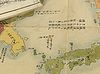 Today, it is significant because it includes the disputed Dokdo Islands (Takeshima / Liancourt Rocks) definitively defined as Korean territory (朝鮮ノ持ニ).
These islands are a current point of diplomatic contention between Japan and South Korea, with both claiming sovereignty by historical precedent – which is why this map is significant. Some early maps and other records identify the islands as Japanese, others as Korean. What makes this issue even more complex is that historically the islands were somewhat unimportant and were not consistently mapped using the same nomenclature. So, while many early maps, issued by Korean, Japanese, and foreign publishers, do identify the islets, they frequently have different names and it is not always completely clear that the islands shown are in fact the Dokdo / Takeshima / Liancourt archipelago. Which is why this map is so significant. The fact that Shihei's map, being essentially Japanese, recognizes Korean sovereignty over the islets has been aggressively used by Korean authorities in their claims.
 The Senkaku Islands dispute
or Diaoyu Islands dispute, concerns a territorial dispute over a group of uninhabited islands known as the Senkaku Islands in Japan, the Diaoyu Islands in the People's Republic of China and Tiaoyutai Islands in the Republic of China (ROC or Taiwan).
Hayashi Shihei positioned on his map the Diaoyutais as belonging to China, not to the kingdom of the Ryukyus which was a vassal state paying tribute to the court in Beijing as well as to the Tokugawa shogunate in Edo or present-day Tokyo. That is the reason why the high court in Tokyo gave the fishing rights to the prefecture of Taihoku (Taipei) rather than to Okinawa while Taiwan was under Japanese colonial rule from 1895 to 1945. For that reason, too, the Empress Dowager of the Qing Dynasty (1644-1911) gave the small islands to her court minister Sheng Hsuan-huai as a fief.
Japan took over the administration of the Senkakus after 1895, following the cession of Taiwan by the Qing court. But the Okinawa chain was occupied by the United States towards the end of World War II. Washington restored the entire island chain to Japanese sovereignty in 1972, but neither Taiwan nor the People's Republic accepts the Diaoyutais as part of the islands thus restored to Japan.
The maps
The maps
Map: 1. Sangoku tsûran yochi rotei zenzu (三国通覧輿地路程全図) [Complete Picture of World Distances of the Outline of the Three Countries] 765 x 535mm.
Including: Sagariin [Sakhalin Island], Kamsikatstoka, Isseo Ye Biskokof [Hokkaido], Grand Niphon [all Japanese Islands], Rioukiou Kokf [Loo Choo Islands], Taiwan, the coast of mainland China from the Sagariin River in the North, down to Kouang Touang & Fou Kian in the South, with Tche Kiang, Nan King, Chan Toung, Tsio Sen Coree [Korea], Liao Touong and Mantsiou [Manchuria] areas nicely shown.
Map 2: Chôsen koku zenzu (朝鮮国全図) [Complete Picture of the Country of Korea] 765 x 535 mm.
A magnificent pictorial map, with yellow outline, showing the whole country and each of its provinces, with the King's Residence located in KING KI [Seoul] with a large black square castle noted. The upper portion or the North, shows Liao Toung & Ju Tchin, with the rivers separating them from Korea. Each province named, with rivers, main towns, villages, mountains & rivers noted. The lower portion shows Tsousima in green, some 40 Ri [miles] from Korea. To the East is the Thsian Chan Koue island. This is a major & primitive European map of Korea.
Map 3: Ezo koku zenzu (蝦夷国全図) [Complete Picture of the Country of Ezo] 970 x 535 mm.
A primitive map of Hokkaido showing Kamsikatstoka or Kouroumouse to the North in red outline, Sagariin Island in green outline, Karafouto-Sima to the West with yellow & brown outline and part of Mantsiou. The main island of Iesso is with brown outline, and shows mountains, rivers, towns and sea routes in Ri [miles], with Province Ooshiou in the south and Matsumaye at the tip of Iesso in green outline, noting Japanese influence.
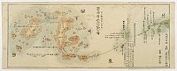
Map 4: Ryûkyû zenzu (琉球全図) [Complete Picture of the Ryûkyûs] 765 x 535mm.
Is a great example of an early primitive European map. Shows the tip of Japan at the North and Kagoshima with adjacent Islands in green. The Ryukyu chain begins in brown, with Oosima & Toknosima, the main island and the citadel Ziouli in heavy black outline, all provinces, cities, mountains noted. The outer islands, South to Yama Island and its smaller islands then Taiwan in yellow. The coast of China in red shows Kyoo To Sio, Fo Ken Sio, Se Kiang Sio, Nan King Sio, San Tong Sio [provinces] to the West. The major sea routes from Japan are recorded with a dotted line in Li [miles] all through the chain and to Fo Ken.
Map 5
Mujintô no zu (無人島之図) Picture of the Uninhabited Islands. 664 x 266 mm.
Shown just below Idzou province in Japan in green outline, along with the scattered islands and the ship route with Ri [miles]. Down to the Ogassawara chain outlined in red.


HAYASHI SHIHEI / KLAPROTH
J.San kokf tsou ran to sets, ou, Apercu général des trois royaumes./ Tr. de l'original japonais-chinois par Mr. J. Klaproth. Ouvrage accompagné de cinq cartes.
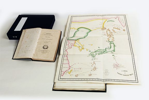
First Western edition. With a large quarto album (330 x 260 mm.) complete with a printed title-page and seven engraved plates, five of which are hand-colored folding maps. Contemporary green cloth, spine with printed title label. Text volume (270x170mm) in full green morocco, spine with printed title label.
[4], vi, [2], 288p., 8p. (270x170mm.) + 1 atlas. The book with slight foxing throughout, the five maps are printed on very thick, heavy paper, exceptionally clean, bright and solid condition.
Sold
First written in Japanese and rendered in Chinese characters in 1785, this is the first Western edition of "Sangoku Tsuran Zusetsu" (Illustrated General Survey of the Three Countries) edited and translated into French by German Orientalist Julius von Klaproth (1783-1835).
Printed for the Oriental Translation Fund of Great Britain. Although certainly an able interpretation and impressive work of scholarship, this edition is most extraordinary for its large quarto album, which includes five magnificent hand-colored, engraved maps:
 Map: 1. "Carte des Trois Royaumes", Including: Sagariin [Sakhalin Island], Kamsikatstoka, Isseo Ye Biskokof [Hokkaido], Grand Niphon [all Japanese Islands], Rioukiou Kokf [Loo Choo Islands], Taiwan, the coast of mainland China from the Sagariin River in the North, down to Kouang Touang & Fou Kian in the South, with Tche Kiang, Nan King, Chan Toung, Tsio Sen Coree [Korea], Liao Touong and Mantsiou [Manchuria] areas nicely shown.
In modern terms, it covers from the Sea of Okhotsk and the southern tip of Kamchatka south as far as Taiwan and the Ogasawara Islands, including the modern-day countries of Japan and Korea, as well as parts of China and Russia.
Today, it is significant because it includes the disputed Dokdo Islands (Takeshima / Liancourt Rocks) definitively defined as Korean territory.
Map 2: "Carte des Huit Provinces du Tchao Sian." [Chosen or Corea]: a magnificent pictorial map, with yellow outline, showing the whole country and each of its provinces, with the King's Residence located in KING KI [Seoul] with a large black square castle noted. The upper portion or the North, shows Liao Toung & Ju Tchin, with the rivers separating them from Korea. Each province named, with rivers, main towns, villages, mountains & rivers noted. The lower portion shows Tsousima in green, some 40 Ri [miles] from Korea. To the East is the Thsian Chan Koue island. This is a major & primitive European map of Korea.
Map 3: "Carte de L'Ile de Ieso", Is a primitive map of Hokkaido showing Kamsikatstoka or Kouroumouse to the North in red outline, Sagariin Island in green outline, Karafouto-Sima to the West with yellow & brown outline and part of Mantsiou. The main island of Iesso is with brown outline, and shows mountains, rivers, towns and sea routes in Ri [miles], with Province Ooshiou in the south and Matsumaye at the tip of Iesso in green outline, noting Japanese influence.
Map 4: "Carte des Iles Riou Kiou", is a great example of an early primitive European map. Shows the tip of Japan at the North and Kagoshima with adjacent Islands in green. The Ryukyu chain begins in brown, with Oosima & Toknosima, the main island and the citadel Ziouli in heavy black outline, all provinces, cities, mountains noted. The outer islands, South to Yama Island and its smaller islands then Taiwan in yellow. The coast of China in red shows Kyoo To Sio, Fo Ken Sio, Se Kiang Sio, Nan King Sio, San Tong Sio [provinces] to the West. The major sea routes from Japan are recorded with a dotted line in Li [miles] all through the chain and to Fo Ken.
Map 5: Carte de Iles Inhabites ou Mou Nin Sima..", shown just below Idzou province in Japan in green outline, along with the scattered islands and the ship route with Ri [miles]. Down to the Ogassawara chain outlined in red. Shows all of the islands in this area from the large Ile Septentrionale and Ile Meridionale with the smaller ones.
All of the maps are folding, the largest folds out to 21 1/4 x 28 1/2 inches, or 540 x 725 mm. Of greatest interest is ALPHABET ET SYLLABAIRE COREEN, sheet size 31.5 x 24 cm., shows 205 Hangul characters and their sounds written in romanized letters along side. This is the first time the Korean Hangul characters were published in the West.
Published in Edo, Japan at the end of the eighteenth-century, "San kokf tsou ran" to sets was written by Hayashi Shihei (1738-1793), a Japanese military strategist, explorer, and writer also known as Rinsifee. In this book, Rinisfee recounts an exploratory survey of the geography of the regions that were then the frontiers of Japan, including Korea, Hokkaido, and the Ryukyu Islands, and provides descriptions of the inhabitants, including the Ainu. Anticipating European infiltration of Japan, in later works Rinisfee would advocate for improved defenses along Japanese frontiers and a stronger maritime presence.
Julius Heinrich Klaproth was the son of a famous father, Martin Heinrich Klaproth, the owner of the pharmacy The White Swan in Berlin and member of the Academy of Sciences, an outstanding scientist – he discovered no less than four chemical elements, among them uranium. As a boy young Klaproth was proficient in science but later on he felt attracted by Oriental languages, to a degree that he went to the Berlin Royal Library to study the Chinese-Spanish dictionary of Father Diaz and other books pertaining to China.
Klaproth published several dozen translations during his lifetime but is probably best known for his 1823 work Asia polyglotta nebst Sprachatlas, one of the first linguistic surveys of Oriental languages. Provenance : With a bound-in page : "This copy was printed for Sir. T.Phillipps, Bart. M.R.S.I. A subscriber to the Oriental Translation Fund".
Sir Thomas Phillipps, 1st Baronet (1792 – 1872) was an English antiquary and book collector who amassed the largest collection of manuscript material in the 19th century. He was an illegitimate son of a textile manufacturer and inherited a substantial estate, which he spent almost entirely on vellum manuscripts and, when out of funds, borrowed heavily to buy manuscripts, thereby putting his family deep into debt.
Phillipps recorded in an early catalogue that his collection was instigated by reading various accounts of the destruction of valuable manuscripts.
Such was his devotion that he acquired some 40,000 printed books and 60,000 manuscripts, arguably the largest collection a single individual has created.


