Maps in Japan
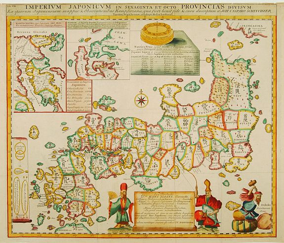
The Japanese cherish a great love for maps. Of old, they adorned all kinds of objects with cartographic images of the world, of Japan, of their town or province. Before the Japanese came into direct contact with Europeans, they made maps that represented the Buddhist world. In that world there were only three great cultures, i.e., India, China, and Japan. For their overseas trade, Japanese navigators relied upon their personal experience, traditional knowledge, and rutters (travelogues).
After the arrival of the Europeans, the Japanese realized that a much larger world existed outside of India, China, and Japan. The world maps created by the Flemish and Dutch cartographers like Abraham Ortelius, Gerard Mercator, Petrus Plancius and Willem Blaeu that the Dutch brought with them revealed what the unknown world looked like. However, European charts and maps were rare and expensive in Japan. Only rich merchants and officials of high rank could afford to buy them or could even set eyes on them. So, they ordered these modern Western maps to be copied on screens. From the results, it appears that not an accurate but an aesthetic representation of the map was most important - no exact copies, but the most beautiful screens resulted.
The free exchange with Europeans stimulated Japanese cartography. The printing technique improved. More accurate maps appeared in greater numbers. However, a broader circulation of Western cartographic knowledge came about only after Japan closed its borders to foreigners, so that the first "modern" Japanese world map, the Bankoku Sozu (general map of the world), was printed only in 1645. This so-called Shoho map was a Japanese copy of a world map that the Italian missionary Matteo Ricci had made in China at the end of the 16th century. It was based on various Flemish and Dutch maps by Ortelius, Mercator, etc. Far into the 19th century, it was frequently copied and reprinted, so that this 16th-century world picture gradually superseded the Buddhist three-culture map.
An 18th-century Japanese scholar even thought that, during this period, the Dutch packed their world maps in wooden boxes, sealed the seams with pitch and rope, and then threw the boxes into the sea "as a gift to the world" to show how the various countries were situated on the globe. Such a map was supposed to have been washed ashore in Japan in the mid-17th century. Nevertheless, it wasn't until the end of the 18th century that the Japanese abandoned the 16th-century world picture of the Shoho map.
The growing interest in Dutch studies in Japan also spurred research into Dutch maps and atlases. In 1792, the famous artist-scholar Shiba Kokan made an exact copy of an 18th-century
world map published by the Amsterdam firm Covens & Mortier.
Though this map had been obsolete for decades, for the Japanese the differences with the Shoho map bordered on the incredible. They acquired a lot of 17th-century Dutch maps, so that, in a short period in Japan, all kinds of "modern" world maps were published, "recently translated from Dutch sources." Realizing that these "modern" maps were primarily 150 years old, Japanese scholars asked
the Dutch to bring the most modern recent world maps to Japan.
These were mostly maps by French and English cartographers who, during the 18th century, had surpassed the Dutch in cartographic knowledge. Based on these maps, the shogunate produced a world map in 1810 that was completely up to date. In some instances, the Japanese map was more accurate than any Western world map.
 Paulus Swaen has for a long time specialized in the Japanese / Netherlands relationship in the 17th and 18th centuries.
The year 2009 marked the 400th anniversary of trade relations between Japan and the Netherlands, prompting us to create web pages and a sales catalog featuring a number of beautiful, rare, and important items, with an emphasis on this unique relationship between the two countries.
