Mapping of South East Asia and Java.
The mapping of South East Asia is a story of adventure and great endeavor involving many nationalities over many years. Four centuries of exploration and discovery lay ahead before the Europeans could claim to have reasonably accurate and comprehensive picture of the South-East Asian region.
When, in July 1511, Alfonso Dalboquerque, Viceroy for Portugal in India, arrived with his fleet of eighteen ships and some 1,400 men, at the town of Malacca on the Malay Peninsular, he knew only what was arrived in Europe from non-European sources. For many centuries beforehand tree had been flourishing trade and contacts amongst the states of the region and further afield to Indian China. The voyagers, Malay, Chinese, Indian, and Moorish, had their own local knowledge and charts to guide them.
Claudius Ptolemy was one of the first to document these travelers’ tales from Asia and elsewhere and to attempt to make geographical sense to them. The early editions of the Geographia included maps covering Asia, making use of Marco Polo’s accounts of his travels in Asia in the thirteenth century.
In the last decade of the fifteenth century, the Portuguese and Spaniards had reached an agreement, the Treaty of Tordesillas, which was intended to demarcate their respective spheres of influence in the remainder of the unknown world. The agreement did not explicitly refer, however, to the asset unexplored region of South-East Asia. Moreover, the captains of the first Portuguese ships to reach the Spice Islands from Malacca placed the islands too far to the east thus risking Spanish claims that they fell within Spain’s area of influence.
When in 1621, the ship Victoria, the sole survivor of Magallan’s expedition around the world, appeared in the Spice Islands, it brought the Spaniards into direct competition with the Portuguese. A potential clash was avoided when the Spaniards turned their attention to the Philippines and left the Spice Islands to the Portuguese.
Despite this activity in the region, information about the discoveries made was only slowly incorporated on maps of the region published in Europe.
Over the next 350 years, cartographers of many European nationalities were to contribute to the mapping of South-East Asia. The best known of the European visitors to the region were the great circumnavigators such as Ferdinand Magellan, Sir Francis Drake, Joris van Spilbergen, William Dampier, George Anson, James Cook and Louis de Freycinet.
A survivor of Magellan’s expedition, Francesco Pigafetta, was responsible for one of the earliest map of the Philippines and the Spice Islands. The Dutchman, Jan Huighen van Linschoten (1563-1610), spent five years as secretary to the Archbishop of Goa and made a notable contribution with his book Itenerario and maps of South East Asia prepared in 1595 with help of material provided from Portuguese sources. Alexander Dalrymple, John Crawfurd, Jean Marie Dayot, and James Horsburgh all spent much of their working lives in the region.
 Java
JavaJava's contact with the European colonial powers began in 1522 with a treaty between the Sunda kingdom and the Portuguese in Malacca. After its failure, the Portuguese presence was confined to Malacca, and to the eastern islands.
In 1596, a four-ship expedition led by Cornelis de Houtman was the first Dutch contact with Indonesia.
Once the Dutch East Indian company V.O.C. was established in Batavia, very detailed mapping became available.
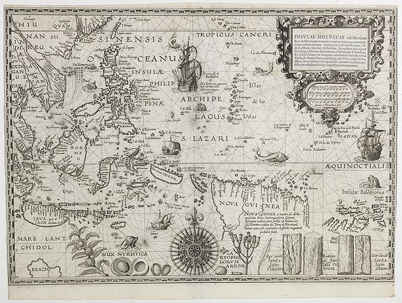
One of the earliest detailed maps was made by Reland and Published by Gerard Van Keulen in 1753.
Interesting reading
- Th. Suarez - Early mapping of South East Asia.
- F. Durand / R.Curtis. - Maps of Malaya and Borneo. Discovery, Statehood and Progress. Maps in the collection of H.R.H.Sultan Sharafuddin Idris Shah '.
- David E. Parry - The Cartography of the East Indian Islands, Insulae Indiae Orientalis.
 Atlas der Nederlandsche bezittingen in Oost-Indie.
This formidable atlas reflects the topographical survey and the prosperous state of the Dutch colonies. It's production was a governmental affair and should be regarded as a follow up to the atlas by Melvill van Carnbée and Versteeg. In most cases,the atlas is loose-leaf because the sheets were published in installments.
The atlas contained 14 double page lithographed maps, in colour; with legenda; inset plans of several cities, i.a. Batavia, Semarang, Soerabaja, Makasser, Amboina; maps: Java & Madoera, West Java, Midden Java, Oost Java, Noord Sumatra, Midden Sumatra, Zuid Sumatra, Banka/ Billiton/ Riouw, Noord Borneo, Zuid Borneo, Celebes, Kl. Soenda Eilanden, de Molukken & Overzichtskaart Ned.-Oost Indischen Archipel.
This magnificent collection included nearly all the major printed maps of the region from the fifteenth to the twentieth century. The earliest cartographical data on Southeast Asia comes from the second-century Alexandrian Claudius Ptolemaeus, whose treatise Geographia held sway throughout the early Renaissance. The work outlines a projection of the spherical world upon a flat surface. For Asia, Ptolemy divided the continent into twelve parts, the eleventh devoted to Southeast Asia.
In the fifteenth century, his work was used to create the first printed maps of the region. The collection boasts examples from the Rome (1478), Ulm (1482), and Sylvanus (1511) editions of Ptolemy. With Columbus's discovery of the New World in 1492, and da Gama's voyage to India in 1498, Ptolemy was found wanting, causing cartographers to produce new maps based on better information.
The first such "modern" map of Asia was produced by Waldseemüller for his 1513 atlas. The collection includes this in its reworked form by Lorenz Fries, who was responsible for the first modern map to deal with Southeast Asia as a cartographic entity, representing a definitive break from Ptolemy. By the end of the 1520s, Portugal, from its Malacca stronghold, had cornered the lucrative spice trade. To protect their monopoly, the Portuguese suppressed cartographic information concerning the Indies, and map publishers had to glean any new information from the accounts of intrepid travelers, such as Pigafetta, whose memoir of Magellan's voyage was used by both Münster for his map of Asia (the first depiction of the continent) of 1540, and by Gastaldi in his 1548 map of Southeast Asia, depicting Singapore for the first time.
Six years later, Gastaldi engraved another map of Southeast Asia, published in Ramusio's Delle navigioni et viaggi, which drew upon the latest logs of the Iberian explorers and, with his map of 1561, it represents an improved model of the area that would influence both Mercator and Ortelius.
The birth of Dutch cartography is closely linked with the country's emergence as a nation-state, its forays into the spice trade, and the weakening of the Iberian hold over the East Indies. In 1570, Ortelius published his Theatrum, the first modern atlas containing a continental and regional map which name Taiwan for the first time. Ten years later, the Dutch Republic was at war with its Spanish masters and was cut off from the spice trade by the Iberian embargo on Dutch shipping. However, by the end of the century, the Dutch had repelled sustained Spanish attacks and gained a foothold in the East Indies.
The endeavour was aided by Jan Huygen van Linschoten, who accessed confidential Portuguese manuscript charts detailing the trade route to the East Indies, and who printed the resulting map in 1596. This map and others by Lodewijcksz and De Bry represent the end of Iberian hegemony over Southeast Asia.
The beginning of the seventeenth century saw the resulting growth of the VOC, the Dutch East India Company. The period also witnessed the golden age of Dutch cartography, with the rise of the two great houses of Blaeu and Hondius-Janssonius.
The collection includes some of their finest work, including Hondius's beautiful "Insulae Indiae Orientalis", Janssonius's "Indiae Orientalis Nova Descripto"; and Blaeu's "India quae Orientalis". In the second half of the century, the printed sea chart became prominent.
Arguably, its greatest exponent was Robert Dudley, and the collection boasts four of his finest charts.
In Amsterdam, meanwhile, Janssonius produced his Atlas Maritimus which, by 1657, included charts of Java, Sumatra, and Borneo. Where Janssonius led, many followed, including Pieter Goos, whose stunning "Paskaerte zynde t'Oosterdeel" is included in the collection.
Thévenot's superb chart and three charts from The English Pilot, bear witness to the emergence of France and England as challengers to the Dutch dominance of cartography, although all four maps are based upon the Portuguese and Dutch manuscript material. The Dutch still held sway in the archipelago at the dawn of the eighteenth century, but their grip on the cartographic field had been loosened by the growth of map-making in France, England and Germany.
In 1726 Dutch cartographic secrecy surrounding the East Indies came to an end, when Valentijn published the confidential VOC charts. The collection contains several fine examples of these charts.
For the remainder of the century and the whole of the next, the output of these three nations was prolific, and the collection reflects their increasing dominance of cartography. Of particular note are Moll's large folio maps of the East Indies of 1717, and Mannevillette's chart of Java. Ptolemaeus, Claudius and Buckinck, Arnold, Tabula Asiae XI, Rome, 1478 Ptolemaeus, Claudius and Holle, Lienhart, Tabula Asiae XI, Ulm, 1482 Ptolemaeus, Claudius and Sylvanus, Beradus, [Southeast Asia], Undecima Asiae Tabula, Venice, 1511 Ptolemaeus, Claudius and Waldseemuller, Martin, Tabula Asiae XI, Strasburg, 1513 Ptolemaeus, Claudius and Fries, Lorenz, Tabula XI Asiae, Strasbourg, 1522 Ptolemaeus, Claudius and Fries, Lorenz, Tabu. Moder. Indiae, Lyon, 1535 Ptolemaeus, Claudius, Fries, Lorenz, Tabula noua Indiae orientalis & meridionalis, Vienne, 1541 Ptolemaeus, Claudius and Munster, Sebastian, Tabula Asiae XI, Basle, 1542-52 Ptolemaeus, Claudius and Ruscelli, Girolamo, India terceranuova tavola, Venice, 1561 Ptolemaeus, Claudius and Ruscelli, Girolamo, Tabula Asiae XI, Venice, 1561 Gastaldi, Giacomo, Terza Tavola, Venice, 1563 Ptolemaeus, Claudius and Ruscelli, Girolamo, Tabula Asiae XI, Venice, 1574 Ortelius, Abraham, Indiae orientalis, insularumque adiacientium typus, Antwerp, 1579 Ortelius, Abraham, Indiae orientalis, isularumque adiacientium typus, Antwerp, 1595-1601 Ortelius, Abraham, Indiae orientalis, isularumque adiacientium typus, ?Rome, 1596-1640 Magini, Giovanni Antonio, India Orientalis, Venice, 1597-1617 Ortelius, Abraham, Indiae orientalis, isularumque adiacientium typus, Antwerp, 1598 De Bry, Theodore after , Lodewijcksz, Willem, Nova tabula insularum Iava, Sumatra, Bornoensis et allarum Mallacum usquae, designantur vada et brevia scopulique interiacentes descripta a C.M.A.L., Frankfurt, 1598 Van Linschoten, Jan Huygen, Exacta & accurata delineatio cum orarum maritimdrum tum etjam locorum terrestrium quae in regionibus China, Cauchinchina, Camboja, sive Champa, Syao, Malacca, Arracan & Pegu, una cum omnium vicinarum insularum descriptione ut sunt Samatra, Java utraq., Timora, Molucca, Philippina, Luconja & deLequeos dicta; nec non insulae Japan & Corea..., Amsterdam, 1598 De Bry, Theodore after Claesz, Cornelius, Descripto Hydrographica, accomodata ad battavorum navagatione in Javam insula mindie Orientalis Seatum ad quam postridie Calendas Aprilis ann 1595 exe Hollandia solverunt et ex qua domum redierunt idus Augustri anna 1597 Horum extus reditusq via his notis demonstratur de hac navigatrone extat descriptio lectu perquam admiranda Eygentliche Und Ausfuhrliche de Orientallischen, Frankfurt, 1599-1628 Langenes, Barent and Claesz, Cornelius, India Orien[talis], Middleburg, 1600 Quad Matthias, India orientalis cuius nobilior pars sunt duo ista quasi ingentia totius Asiae promontoria in coeanum versus meridiem proiecta, cum suis insulis, Cologne, 1600 Ortelius, Abraham, India Orien[talis], Antwerp, 1601 Porcacchi, Thomaso, Isole Molucche, Venice, 1605 Pontanus, Johannes Isacius, Tabula Geograph. In qua Eurpoae, Africae Asiaeq et circulacentium insularum orae maritime accurate describunturet ad intelligentia navigationum Indicaru accommodantur, Amsterdam, 1614 De Bry, Johann, Theodore, [Mar di India], Frankfurt, 1619 Herrera y Tordesillas, Antonia after De Velasco, Lopez, Descripcion de las Indias del poniente, Frankfurt, 1632 Mercator, Gerard and Hondius, Henricus, Insulae Indiae Orientalis praecipuae, in quibus Moluccae celeberrimae sunt, Amsterdam, 1623 Hondius, Henricus, India Orientalis, Amsterdam, 1630 Janssonius, Johannes, India Orientalis, Amsterdam, 1630 Mercator, Gerard and Hondius, Henricus, Insulae Indiae Orientalis, Amsterdam, 1630 Janssonius, Johannes, Indiae Orientalis nova descriptio, Amsterdam, 1633-36 Hondius, Jodocus, India Orientalis, Amsterdam, 1636 Merian, Matthaus, India Orientalis et insulaeadiecentes, Frankfurt, 1638 Boisseau, Jean after Mercator, Gerard, Indies Orientalles ou du Gange, Paris, 1643 Boisseau, Jean after Mercator, Gerard, Les Iles des Indes Orientalles, Paris, 1643 Commelin, Issac, Mar di India, Amsterdam, 1644 Janssonius, Johannes, India quae orientalis dicitur, et insulae adiacentes, Amsterdam, 1645-58 Dudley, Robert, Carta prima generale dell'Asia, Florence, 1661 Dudley, Robert, D' 'Asia, Carta III particolore del mare d'India sino allo stretto di Sunda fra l'isole di Sumatra e di Java, Florence,1661 Dudley, Robert, D'Asia Carta XV Carta particolore dell'Isole Celebes e Giliolo parte Austriele di Butto, Batuliar, Timor, Seram, Banda, e Amboina e altre Isolete, Florence, 1646 Dudley, Robert, Carta particolore del stretto di Sunda fra L'Isole di Sumatra e Iaumaggre, Florence, 1661 Buseliunus, Gabriel after Ortelius, Abraham, India Orientalis, Augsburg, 1658 Janssonius, Johannes, Mar di India, Amsterdam, 1659 Blaeu, William, India quae orientalis dicitur, et insulae adiacentes, Amsterdam, 1664 Janssonius, Johannes, India quae orientalis dicitur, et insulae adiacentes, Amsterdam, 1664 Kircher, Athenasius, Tabula Geographica hydrophylacium Asiae Majoris exhibens, quo omnia flumina sive proxime sive remote per occultos maeandros originem suam sortiuntur, Amsterdam, 1665 Kircher, Athenasius, Tabula Geographica hydrophylacium Asiae Majoris exhibens, quo omnia flumina sive proxime sive remote per occultos maeandros originem suam sortiuntur, Amsterdam, 1665 Goos, Pieter, Paskaerte zynde t'Oosterdeel van Oost Indien met alle de Eylanden daer ontrendt geleegen van C. comorin tot aen Iapan, Amsterdam, 1666 De Wit, F[rederick], Tabula Indiae Orientalis emendata a F. de Wit, Amsterdam, 1670 De Wit, F[rederick], Tabula Indiae Orientalis emendata a F. de Wit, Amsterdam, 1670 [Speed, John], A new map of east India, London, 1676 Morden, Robert, The Isles of Sonda, Robert Mordern (Published in 'Geography Rectified or a Description of the World...', 1680 [Mallet, Allain], Inde, Paris, 1683 [Mallet, Allain Manesson], Isles de la Sonde vers l'Occident, Paris, 1683 [Mallet, Allain Manesson], Isles de la Sonde vers Orient, Paris, 1683 Rossi, Giacomo, Isole dell'India cioe le Molucche le Filippine e della Sonda parte de paesi di nuova scoperta e l'isole de Ladri nel Mare del Zud, Rome, 1683 [Mercator, Gerard and Hondius, Henricus], Insulae Indiae Orientalis, Rome, 1690 Coronelli, [Vincenzo], Isole dell'Indie, divise in Filippine, Molucche, edella Sonda, descritte e dedicate dal P. Coronelli, Cosmografo della serenissima Republica di Veneto, Venice, 1691-1696 Visscher [II] Nicolas, Indiae orientalis, nec non insularum adiacentium, nova descripto per Nicolaum Visscher, Amsterdam, 1698 Visscher [II] Nicolas, Indiae orientalis, nec non insularum diacentium, nova descripto per Nicolaum Visscher, Amsterdam, 1698 [Orlearius, Adam], Delineatio Indiae Orientalis quaelumen dabit huic itinerario et historijs, ?Amsterdam, ?1700 Allard, Hugo, Nova Tabula India Orientalis Hugo Allardt execudit jnde Kalverstraet inde Werelt Caert, Amsterdam, 1702-1705 [Scherer, Heinrich], Asiae pars Australis indicae cum suis naturae dotibus, Munich, 1702- 1710 [Scherer, Heinrich], Insulae indicae cum terris circumvicinis, Munich, 1702- 1710 [Scherer, Professor Heinrich], Insulae indicae cum terris circumvicinis, Munich, 1702- 1710 AA, Pieter Vander, D'Indiaanze Landschappen, zeen en eylanden, van Couchin Af, totinde Moluccos, En na by George Eylanden, Leiden, 1707 [Thornton, Samuel], A chart of the easternmost part of the Indies and China, from Cape Cormarine to Iapan with all the adjacent islands, London, 1711 [Varea, Alphonsus Lasor a and Savolarola, Raffaello], India Orientalis, Padua, 1713 [Renard, Louis after de ,Wit, Frederick], Orientaliora Indiarum cum insulis adjacentibus a promontorio C.Cormorin ad Iapan, Amsterdam, 1715 Moll, Herman, A chart of the east Indies with the coast of Persia, China and also the Philipina, Moluca and sunda Islands &c., London, 1720 Moll, H[erman], The Principle Islands of the East Indies. Explaining what belongs to England, Spain and Holland &c., London, 1729 Tirion, Isaac, Nuova Carta delle isole di Sunda come Borneo , Sumatra e Java Grande &c., Amsterdam, 1740-80 Bowen, Eman[uel], A new and accurate map of the east India Islands laid down according to the latest discoveries and agreeable to the most approved maps and charts, London, 1744-47 [Hamilton, Alexander], A map of Java, Borneo and the islands to the eastward of them as far as Nova Guinea, London, 1744 [Hamilton, Alexander], A map of the dominions of Johore and of the Island of ths sumatra with the Adjacent Islands, London, 1744 Heydt, J[ohann] W[olfgang], India Orientalis, Nuremberg, 1744 Bellin, N[icolas], Suite de l'ocean oriental contenaut les Iles de la conde, les Costes de Tunquin et de la Chine, les isles du Japon, les Philippines Moluques, dressee sur les divers manuscrits du depost des plande la marine, Paris, 1746 Rouge [Geoge Louis le], Isles de la Sonde, Paris, 1748 Robert de Vaugondy [Gilles], Les Isles de la Sonde par le Sr. robert de Vaugondy fils de Mr. Robert Geog. Du Roi. Avec privilege 1749, Paris, 1749 [Nolin, ean Baptiste II], Les Indes Orientales et leurarchipel assujetties aux observations astronomiques, 1750 [Bowen, Emanuel after Gibson, John], East India Islands, London, 1758 Bellin, N[icolas], Carte des Isles de Java, Sumatra, Borneo &c. les detroits de la Sonde Malaca et Banca Golfe de Siam &c, Paris, 1764 [Salmon, Thomas], East Indies, London, 1769 Bonne, [Rigobert], Carte Hydro-Goe-Graphique des Indes Orientales en deca et au dela du Gange avec leur Archipel, Paris, 1771 Bellin, {Jacques Nicolas], Carte des Isles de Java, Sumatra, Borneo &c. les detroits de la Sonde Malaca et Banca Golfe de Siam &c [Title repeated in Dutch], Amsterdam, 1772-1780 Lattre [Jean], Les Indies Orientalles pour la Concorde de la Geographie des differents ages, Paris, 1772 [Chatelain, Henri Abraham], Le Indie, Paris, 1778 [Robert de Vaugondy, Didier and Gilles], Les Isles de la Sonde, Moluques, Philippines, Carolines, et Mariannes, Paris, 1778 [Bonne, Rigobert], Cartes eds isles de la Sonde et des Isles Moluques, Geneva, 1780 [Delamarche, Charles Francois, after Robert de Vaugony, Giles and Didier], Les Indes Orientales et leur archipel, assujetties aux observations astronomiques, Paris, 1784 Bonne, [Rigobert], Le presque'isle de l'Inde au de la du Gange, avec l'archipel des Indes. Partie occidentale, Paris, 1785 [Bonne, Rigobert], Les Indes Orientales et leur archipel, Paris, 1785 Zatta, Antonio, Le Indie Orientali e loro archipelago, Venice, 1799 Rusell, Junior, JC, East India Islands, London, 1810 Cary, J[ohn], East India Is[ands], London, 1813 Starling, Thomas, East India Islands, London, 1840 Justus, Perthes Geographische Verlagsanstalt, Neu-Guinea und Benachbarte Inslen, Aus H. Berghaus Karte, Gotha, 1869 [Pontanus, Johannes Isciaus], Amboina ad viumu descripta, Amsterdam, 1614 [Bellin, Jacques Nicolas], Carte particuliere de l'Isle d'Amboine, Paris, 1746-1770 [Bellin, Jacques Nicolas], Plan d'Amboine tel qu'il etoit en 1718, Paris, 1746 - 1770 [Gottfired, Johann Ludwig], Inf: Macjan, Inf: Bactjan, Frankfurt, 1631-1657 [Pontanus, Isaac Johan], Baly, Amsterdam, 1616 [Valentyn, francois], Kaart van het Eyland Baly, Amsterdam, 1726 [Bellin, Jacques Nicolas], Das Eyland Baly oder Klien Java, Paris, 1750 Tardieu, Louise [Francois], Ile de Baly ou Petite Java, Paris, 1770 [Bellin, Jacques Nicolas], Isle de Baly 't Eiland Baly, Paris, 1772-1780 [Janssonius, Johannes], Insularum Bandanensium novissima elineatio, Amsterdam, 1680-1709 Coronelli, [Vincenzo], [1] Isole di Banda nelle Molucche [2] Isle di Solor, Venice, 1692 [Valentijn, Francois], Kaart der zuy-wester eylanden van Banda, Paris, 1724-1726 [Bellin, Jacques Nicolas], Isles de Banda, Paris, 1746-1770 [Bellin, Jacques Nicolas], Isles de Banda Eylanden van Banda, Amsterdam, 1722-80 Tardieu, Louise, Iles de Banda, Paris, 1780 [Ogilby, John], Ware affbeeldinge wegens het Casteel ende Stadt Batavia gelegen opt groot Eylant Java Anno 1669, London, 1670 [Mallet, Allain Manesson], Cita delle Batavia, Paris, 1683 [Mallet, Allain Manesson], A Mapp of Batavia with all itts forts, London, 1704 [Nieuhoff, John], A Mapp of the Islands before Batavia, London, 1704 [Salmon, Thomas], A Plan of the City and castle fo Batavia, London, 1746 Homann Heirs, Bder Hallandisch-Ostindianischen Compaigne weltberuhmte Haupt- Handels und Niederlags Stadt Batavia in Asien auf dem grossen Eyland Iva in dem Konigreich Iacarta Nord- Westlich gelegen..., Nuremberg, 1747 Jeffreys, Thomas, Plan of the city of Batavia, London, 1750 [Bellin, Jacques Nicolas], Batavia, Amsterdam, 1772-1780 [Bellin, Jacques Nicolas], Batavia assiege en 1629. Batavia Anno 1629 belegerd, Amsterdam, 1772-1780 [Bellin, Jacques Nicolas], Batavia assiege en 1629. Batavia Anno 1629 belegerd, Amsterdam, 1772-1780 [Bellin, Jacques Nicolas], Carte des environs de Batavia, Amsterdam, 1772-1780 [Bellin, Jacques Nicolas], Carte des environs de Batavia/ Karte van de Buitenstreeken van Batavia, Amsterdam, 1772- 1780 [Luepken, Claudius Anthony van], Grundres der Stadt und Citadelle Batavia Erklarung der zahlen wornit die Bollwerke und Thore derStadt und Citadelle bezeichnet werden, "Peter Conradi", 1785 Gold, Joyce, Batavia, London, 1812 Wright, Benjamin, Boreo Insula, Amsterdam, 1601 [Janssonius, Johannes], Insula Borneo et occidentalis pars celebis cum adjacentibus insulis, Amsterdam, 1680-1709 [Desbordes, Jacques after Bry, Theodore de], Borneo Insula, Amsterdam, 1706 [Ptolomeus, Claudius and Munster, Sebastian, Java Insula, Basel, 1544-1552 [Hulsius, Levinus], Iava Maior, ?Frankfurt, 1590-1650 Wright, Benjamin, Iava Maior Benjamin Wright caelavit, Middleburg, 1602-1606 [Janssonius, Johannes], Insula Iavae cam parte insularum Borneo Sumatrae, et circumjacentium insularum novissima delineato, Amsterdam, 1657-1680 [Desbordes, Charles], Iava Maijor, Amsterdam, 1706 AA, Pieter Vander, T Koninkryk sunda met dat van Iava by d'Inwoonderen voor Eiland Gehoudeen, en door den Hr. I.B. de Lavanha, als twee Eylanden Bescreven, Leiden, 1707 Thornton, Sam[uel], A large draught fo the east end of Java and Madura shewing the Streights of Bally, London, 1711 Thornton, Sam[uel], A new and correct chart of part of the island of Java from the west end to Batavia with the streights of Sunda, London, 1711 AA, Pieter Vander , Het Eiland Java zoo als het sederd de tyden der Portugysen by de Ed. Oost- Indize, Leiden, 1714 [Bellin, Jacques Nicolas], Nouvelle carte del'Isle de Java dressee suivant, Paris, 1746-1770 [Bellin, Jacques Nicolas], Nouvelle carte de l'Isle de Java dressee suivant les observations les plus recentes, faites parordre de la Comp. Holl. Des Indes orientales, Amsterdam, 1772-80 [Thorn, Major William], The Landing of the British Army at Chillinching on the Island of Java, 4th Augt. 1811, London, 1815 AA, Peter Van der. , La Ville de Materan capital du roiaume de meme nom, avec ses environs. Le tout environne de montagnes qui lui serve de murailles., Leiden, 1729 [Pontanus, Johannes Isciaus], [The town of Madura on the island of Madura with the four ships of Houtman's fleet], Amsterdam, 1614 [Bertius, Petrus], Moluccae Insulae, Leiden, 1602 [Hondius, Jodocus], Moluccae Insulae, Amsterdam, 1618 [Blaeu, Williem], Moluccae insulae celeberrimae, Amsterdam, 1640-55 [Janssonius, Johannes], Insularum Moluccarum Nova descriptio, Amsterdam, 1648-51 [Sanson D'Abbeville, [Nicolas], Les Isles Molucques; Celebes, Gilolo, &c, Paris, 1652 Morden, Robert, The Molucca Islands &c, London, 1680-1700 [Mallet, Allain Manesson], Isle Molucques, Frankfurt, 1684 Coronelli, [Vincenzo], Le Molucche dedicate al moto reu pre maestro carlo Tosi, min congia provinceale, Venice, 1692 Coronelli, [Vincenzo], Le Molucche dedicate al moto reu pre maestro Carlo Tosi, min congia provinceale, Venice, 1692 AA, Peter Van der. , Les Isles Molucques, tres exactement repressentees selon les plus nouvelles observations des meilleurs Goegraphes, Amsterdam, 1714-29 AA, Peter Van der. , De Moluccios en andere Speceri-Eilanden in d'Ooost Indien, Leiden, 1714 [Blaeu, Williem], Moluccae insulae celeberrimae, Amsterdam, [c.1730] [Le Rouge, Lieutenant George-Louis], Isles Moluques, Paris, 1748-1767 [Bellin, Jacques Nicolas], Carte particuliere des lsles Moluques, Paris, c.1750 Bonne, [Rigobert], Carte des Isles de la Conde, et des isles Moluques, Paris, 1780 [Pontanus, Johannes Isciaus], [A view of the island of Ternate with the town Gamme lamme [and to verso] A print depicting the naval engagement between the Dutch and the Portuguese fleets, Amsterdam, 1614 Da Fer, N[icolas], Les Isles Philippines et celles des Larrons ou de Marianes, Les isles Moluques et de la Sonde, avec la presqu' isle de l'Inde de la le Gange ou orientale, Paris, 1706 Robert de Vaugondy [Didier and Gilles], Isles Philippines et Moluques, Paris, 1749 [Bellin, Jacques-Nicolas] , Carte des Isles Philippines Celebes et Moluques, Paris, 1746-1770 [Gottfired, Johann Ludwig], Solor, Frankfurt, 1631-57 D'Apres de Mannevillette, [Jean-Baptiste], A New Plan of the Straits Situated to the East of Java & Madura commonly called the Straits of Bali and of Pondi and Respondi, London, 1794 [Bellin, Jacques-Nicolas], Carte des Isle Celebes ou Macassar, Paris, c.1763 Woodward, Capt. D. , Skizzirte charte von der Insel Celebes, Prague, 1812 [Bordone, Benedetto], [1]iava minore [2] necumera, boteghon, patera, locaz, Venice, 1547 [Ramusio, Giambattista], Sumatra, Venice, 1565 [Thevet, Andre], [Sumatra], Paris, 1581 [Metellus, Johannes], Sumatra cum circumiacentibus insulis, Cologne, 1601 [Munster, Sebastian], Sumatra ein grosse insel so vonden at en Geographen Taprobana ist genent worden, Basle, 1588-1628 [Munster, Sebastian], Sumatra ein grosse insel so vonden at en Geographen Taprobana ist genent worden, Basle, 1588-1628 [Janssonius, Johannes], Sumatrae et insularum locorumque nonnullorum circumia centium tabula nova, Amsterdam, 1657-80 Bellin, [Jacques-Nicolas], Karte von dem Eylande Sumatra nach den Tagebuchern der Schiffer und vielen Karten die beyder Kammer wegen des See wesens in Verwahrung liegen [Title repeated in French], Paris, 1764 Bellin, [Jacques-Nicolas], Karte von dem Eylande Sumatra/ Carte de l'Isle de Sumatra nach den Tagebuchern der Schiffer/ dresse sur les journaux des Navigateurs, Paris, 1764 [Pontanus, Johannes Isciaus], [A View of the Bay of Bantam with Houtman's ships], Amsterdam, 1614 Heydt, J[ohann] W[olfgang], Particular See-Charte des Strass Sunda, nebst denen darinnen befindlichen Insulen und Sanbancken, ?Wilhermsdorf, c.1744 Bellin, [the younger, Jacques-Nicolas], Carta dello stretto della Sonda, ed isole vicine, Paris, 1781 [Prevost D'Exile, Antoine Francois], I[sle] Timor, Paris, c.1780 [Prevost D'Exile, Antoine Francois], Laphao, Paris, c.1780 [Munster, Sebastian], India Extrema XIX nova tabula, Basle, 1540 [Munster, Sebastian], Tabula orientalis regionis, Asiae scilicet etxtremas complectens terra & regna, Basle, c.1545 [Ptolomeus, Claudius, Munster, Sebastian], Tabula Asiae VIII, Basle, 1545-52 [Bunting, Heinrich], Asia Secunda Pars Terrae Informa Pegasi, Hanover, 1581 [Munster, Sebastian], Asia wie es jetziger zeit nach den furnemesten Herzschafften abgetheilet und beschiben ist, Basle, 1588-1628 [Munster, Sebastian], Asia wie es jetziger zeit nach den furnemesten Herzschafften abgetheilet und beschiben ist, Basle, 1588-1628 [Ortelius, Abraham], Asiae noua descr[iptio], Antwerp, 1588-90 [Ortelius, Abraham], Asiae nova descriptio, Antwerp, 1588-1612 [Ortelius, Abraham], Asiae nova descriptio, Antwerp, 1588-1612 [Ptolemaeus, Claudius- Magini, Giovanni Antonio], Tabula Aisiae VIII, Venice, 1596-1621 [Quad, Matthias], Asia partivorbis maxima MDXCVIII, Cologne, 1598 [but 1600] Rosaccio, Giuseppe, Asia, Venice, 1598 [Mercator, Gerard], Asia ex magna orbis terre descriptione Gerardi Mercatoris desumpta, studio et industria G.M. Iunioris, Amsterdam, 1609-19 [Mercator, Gerard and Hondius, Henricus], Asia, Amsterdam, 1609-21 Mercator, Gerard and Hondius, Jodocus, Asia ex magna orbis terre descriptione Gerardi Mercatoris desumpta, studio et industria G.M. Iunioris, Amsterdam, 1613-30 Mercator, Gerard and Hondius, Jodocus, Asiae nova descriptio auctore Jocodo Hondio, Amsterdam, 1613-16 Mercator, Gerard and Hondius, Jodocus, Asiae nova descriptio auctore Jocodo Hondio, Amsterdam, 1613-19 [Cluver, Philipp], Asia antiqua et nova, ?Lieden, 1624 or later [Cluver, Philipp], Asia antiqua et nova, Lieden, 1624 or later S[peed], J[ohn], Asia with the islands adioyning described, the attire of the people, & townes of importance, all of them newly augmented by I:S:, London, 1626 [but 1627] Blaeu, William, Asia noviter delineata, Amsterdam, 1635-38 [Mercator, Gerard. Hondius, Henricus. And Janssonius, Johannes], Asia recens summa cura delineata, Amsterdam, 1646-57 Sanson D'Abbeville, N[icolas], Asie, Paris, 1650 Visscher, N[icolaes I], Asiae nova delineatio, Amsterdam, 1656-77 De Wit, Frederick, Asiae nova descriptio, Amsterdam, 1660 De Wit, Frederick, Asiae nova descriptio, Amsterdam, [c.1660] Overton, J[ohn] [after] Visscher, N[icolaes], A new plaine and exact map of Asia discribed by N.I.Visscher and rendered into English with the habits of the countries and manner of the chief cities, London, 1671 Rossi, Gio[vanni] Giacomo de., L'Asia Nuouamente corretta, et accresciuta, secondo le relationi piu moderne da Guglielmo Sanson geografo di S.M Christma, Rome, 1677 Danckerts, J[ustus], Accuratissima totius Asia tabula recens emendata per I. Danckerts, Amsterdam, c.1680 De Wit, Frederick, Accuratissima totius Asiae tabula in ommes partes divisa, de novo correcta, ac in lucem edita per Fredericum de Witt, Amsterdam, 1689-1702 Overton, J[ohn] and Lea, Philip, A new mapp of Asia divided into kingdoms and provinces..., London, c.1690 Danckerts, Theodorus, Amsterdam, 1696 Wells, Edward, Oxford, c.1700 Wells, Edward, ?London, c.1700 Allard, Carel, Amsterdam, 1705 Schenk, Peter [after] Delisle, William, Amsterdam, 1708 Senex, John, Asia corrected from the observations communicated to the Royal Society at London and the Royal Academy at Paris, London, [c.1713] Price, C[harles], Asia according to ye newest observations by C. Price Geographer to the Queen, Cornhill, [c.1713] Moll, Herman, To the Right Honourable William Lord Cowper, Lord High Chancellor of Great Britain this map of Asia..., London, [1715] Homann, [John Baptiste], Asiae recentissima delineatio, qua status et imperia totius orientis unacum orientalibus indiis exhibentur, Nuremberg, [1716] Schenk, Peter, Asiae in tabula geographica delineatio admentem novissimorum eorumq. Optimorum feographorum emendata, indicibus utilissimis aucta et adusum Tyronum imprimis geographicorum variis compendiosae methodi adminiculis accomodata, Amsterdam, [c.1720] Covens, [Johannes]and Mortier, [Cornelis], L'Asie dressee sur les Observations de M[esse]rs de l'Academie Royale des Sciences & de Sanson, Nolin, De Fer, de l'Isle & Principallement sur la Carte que Monsieur..., Amsterdam, [c.1730] Homann, [John Baptiste], Asiae recentissima delineatio, qua status et imperia totius orientis unacum orientalibus indiis exhibentur, Nuremberg, [c.1730] Homann Heirs, Asia secundum legitimas projectionis steriographicae regulas et juixta recentissimas obervation et relationes, [Nuremberg], 1744 Clouet, l'Abbe [Jean Baptiste Louis], Carte d'Asie divisee en ses Principaux Etats..., Paris, 1776 D'Anville, Jean-Baptiste Bourguignon, Asia and Its Islands according to d'Anville: divided into Empires, Kingdoms, States, Regions &c. with the European possessions and settlements in the East Indies..., London, 1794 Cary, J[ohn], Asia, London, [c.1810] Van Keulen, Gerard, Insula lavae, Amsterdam, 1682 Valentyn, Francois, Nieuween zeer naaukeriger kaart van eyland Java, Amsterdam, 1726 Mercator, Gerard, Insulae Indiae Orientalis, Amsterdam, 1606 Blaeu, William, Asia / noviter delineate, Amsterdam, 1640 Coroneli, V.M., Isole dell'Indie, Venice, 1680 Linschoten, Jan, Huygen van Ailhae Cidade de Goa Metropolitana da Indiae, Amsterdam, 1595
