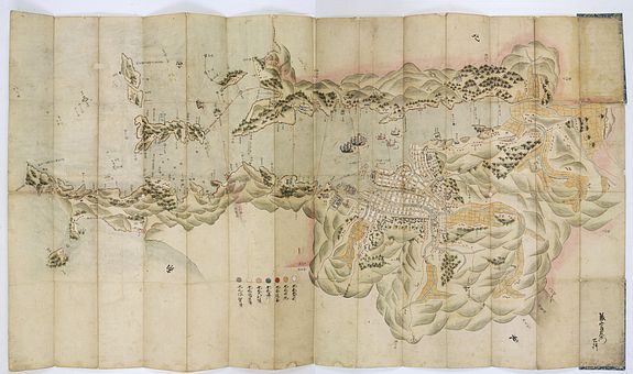
Plan of the port and city of Nagasaki
AN EXTRAORDINARY RARE AND EARLY JAPANESE MANUSCRIPT PLAN OF NAGASAKI
A detailed manuscript plan of the navigation into Nagasaki, the town, its layout and surrounding areas, orientated to the North West, names in Japanese Katakana and classical Chinese, signed in lower right corner "Chokenemon".
P.O.R.
This manuscript map predates all printed maps and shows a detailed layout of the town and streets, with street names and individual houses named, the valleys extending behind the town, on the waterfront, Dejima island (the artificial island built for the Portuguese, and since occupied by the Dutch East India Company), southwest of the Dejima, the Tojin district, is clearly shown with small buildings and blue roofs, where the Chinese lived.
A color scale at the lower margins shows seven colors, grey for the lands of the feudal lord, yellow Shimabara land, violet Omura family land, blue for water, red for roads, dark yellow for rice fields and white for the city center.
Nagasaki was a small fishing village in the 16th century but grew to be one of the most important cities in Japan by the late 17th century. The Dejima was built in 1634-36 for the Portuguese traders, who were expelled in 1639, and their place was taken by the Dutch V.O.C. trading out of Batavia. The profits of this only foreign trading port in Japan brought considerable wealth to the city. It was also a place where European ideas began to infiltrate Japanese society in terms of medicine and science.
Due to the Dutch presence; Japan learned many aspects of the scientific and technological revolution occurring in Europe at that time, helping the country build up the beginnings of a theoretical and technological scientific base, which helps to explain Japan's success in its radical and speedy modernization following the opening of the country to foreign trade in 1854.
