Antique maps of the Guianas & Suriname
The Guianas & Suriname
One of the first maps to show the northern coastline of South America, from roughly the Amazon River to Trinidad Island, was created by Hessel Gerritsz.
Hessel Gerritsz (1581-1632), former apprentice of Willem Blaeu; and Blaeu’s predecessor as chief cartographer of the Dutch East India Company. Gerritsz enjoys a very high reputation for his critical approach towards his sources. Most of Gerritsz’ work exists only in manuscript, and these maps published by de Laet, are among the only printed Gerritsz maps available to the collector and institution today. Published in first issue of Joannes De Laet's "Nieuwe Wereldt ofte Beschrijvinghe van West-Indien".
Surinam plantation maps
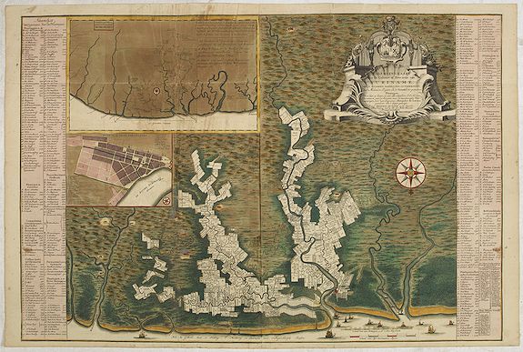
The first map of Suriname showing the boundaries of individual plantations (Amsterdam: Frederick de Wit, 1688) was commissioned by Cornelis van Aerssen van Sommelsdijck (1637-1688), the first governor of Suriname. Alexander de Lavaux's monumental wall map followed in 1737. Several derivative editions of this map were subsequently printed.
Both of these maps were limited to the plantations along the Suriname River, Commewijne and Cottica. The eight-page map by Johan Christoph Heneman (Amsterdam: Gerard Hulst van Keulen, 1784), was the first to map the entire coastal area up to the Berbice. Moreover, Heneman's map was the first to attempt to map the main rivers further inland. J.H. Moseberg’s map from 1801 was, again, limited to the core colonial area of Suriname. All these maps have a similar scale, ranging from 1:150,000 to 1:200,000.
