Browse Listings in Maritime

Universe Europae Maritime Eiusque Navigationis Descriptio. Generale Pascaerte van Europa . . .
This general chart of north-western Europe and the surrounding coastal waters is from the rare pilot-guide De Spiegel der Zeevaerdt , printed by Christopher Plantin in Le...
Date: Leyden, 1584

Beschrijvinge vande de zee Cuften va Vlanderen en Picardien. . .
DUTCH TEXT EDITION. A detailed chart of the coast of Flanders and Normandy decorated by a large colorful baroque title cartouche, and the coat of arms of Flanders with a ...
Date: Leiden, Plantijn, 1585

De zee cuften tufschen Dovere en Orfords nesse, daer de Teemse de Vermaerde Rivire van Lonen gelegens is. . .
A detailed chart of the English Channel coastland. Decorated by a colorful title cartouche and scale cartouche, one compass rose, several vessels and sea monsters. A very...
Date: Leiden, Plantijn, 1585

Belchrijuinghe vande zee custen van Engelandt. . .
A rare Dutch text edition of this detailed early chart of the northern coast of England. West to the top. The mileage cartouche has no Latin captures. Decorated by a colo...
Date: Leiden, Plantijn, 1585

Zee caerte vande Sondt tvermaerste van Danemarcke . . .
A detailed chart of the coast of Denmark and its islands, Copenhagen in the center of the chart. West to the top. It is decorated by a title, scale and descriptive cartou...
Date: Leiden, Plantijn, 1585
![Pisces in mari alati [flying fish attack]](/uploads/cache/48527-250x250.jpg)
Pisces in mari alati [flying fish attack]
Flying fish attacking a Portuguese ship in the West Indian Waters.Read more about "Les Grand Voyages" by Theodore De Bry [+]
Date: Frankfurt, 1594
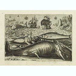
Virulus marinus. Cete (Whale and whaling scene)
Whale and whaling scene, set against a mountainous landscape in the manner of Pieter Brueghel the Elder. Plate number 1. The engraving is copied after Adrian Collaert pla...
Date: Antwerp, after 1598
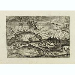
Glaucus, Cantharus, Salpa, Rarus. (Piscium Vivæ Icones - Fish)
Depiction of Glaucus, Cantharus, Salpa, Rarus. Fish set against a mountainous landscape in the manner of Pieter Brueghel the Elder. Plate number 12. The engraving is copi...
Date: Antwerp, after 1598
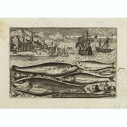
Faber piscis, Asellus minor, Conger, Alburinus. (Piscium Vivæ Icones - Fish)
Depiction of Faber piscis, Asellus minor, Conger, Alburinus. Fish set against a mountainous landscape in the manner of Pieter Brueghel the Elder. Plate number 14. The eng...
Date: Antwerp, after 1598
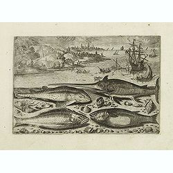
Gladius piscis, Galeus piscis, Araneus, Mugil. (Piscium Vivæ Icones - Fish)
Depiction of Gladius piscis, Galeus piscis, Araneus, Mugil. Fish set against a mountainous landscape in the manner of Pieter Brueghel the Elder. Plate number 15. The engr...
Date: Antwerp, after 1598

(Sea-chart of Catalunia, Languedoc, Provence, Cote d'Azur, Riviera, Corsica with Marseille, Cannes, Nice, Monaco.)
This very rare chart is important as the first printed sea chart of France's Mediterranean coast, also depicting Catalunya's northern coast, the Italian Cote d'Azur till ...
Date: Amsterdam, 1607
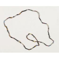
Dutch Trade Bead.
An extremely rare necklace made from authentic early 17th-century glass beads produced in the Netherlands. This rare and early Dutch Trade bead is built up from irregular...
Date: Middelburg, before 1623
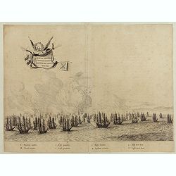
Le grand combat ov Monsieur de Montmorancy admiral de Fance . . .
Attractive view of the naval Battle of Saint-Martin de Ré, fought on 15 September 1625 between the Huguenot fleet of La Rochelle, commanded by Admiral Jean Guiton- Admir...
Date: Paris, 1625

Carta particolare che comincia con il c.apo Aldea è Finisce con il capo Degortam. . .
Dudley’s magnificent chart shows the south west coast of Africa with the Tropic of Capricorn, located at about 23.5 degrees south. Without the privilege, but with "...
Date: Florence, 1645
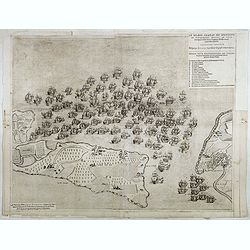
Quartum Praelium Coniovian inter et Fluvium Rio Grande XVII Ian
Decorative engraving of the fourth sea battle with the Portuguese fleet offshore at the Rio Grande, in1640. Engraved by J. van Brosterhuyzen after a design by Frans J. Po...
Date: Joannes Blaeu, Amsterdam 1647

Currus Veliferi Illmi. Pr. Mauritii Nassouvii. (Prince Maurits' sailing-carriage, designed by Simon Stevin. )
Prince Maurits' sailing carriages had been designed by Simon Stevin. The Prince, always accessible to new inventions of his old instructor, could not please the foreign a...
Date: Amsterdam, 1649
-250x250.jpg)
Vues du port de Llivourne. (set of 6 prints)
Sought-after complete suite of 6 engravings by S[tefano] Della Bella [1610-1664]. in a second state (of 2).Della Bella was born in Florence in 1610, and studied the art ...
Date: 1654-1655

Pascaerte van Brazil en Nieu Nederlandt van Cuorvo en Flores.
A rare chart of the Atlantic Ocean from the first edition of Hendrick Doncker's Zee-Atlas, of which no surviving example is known.Although the idea of its unusual coverag...
Date: Amsterdam, 1658
![De Texel Stroom met de gaten vant Marsdiep. [with] Caarte van De Mase ende het Goereesche Gat.](/uploads/cache/12097-250x250.jpg)
De Texel Stroom met de gaten vant Marsdiep. [with] Caarte van De Mase ende het Goereesche Gat.
Two decorative charts on one sheet, one depicting Texel and the entrance of the Zuider Zee with an inset showing the north coast of West-Friesland, the other depicting th...
Date: Amsterdam, 1660

Cust van Hollant Tussen de Maes ende Texel.
Uncommon chart of the coast of Holland, including the southern tip of Texel. East at the top. Two fine compass cards, soundings and a large Bree Veerthien offshore.Piete...
Date: Amsterdam, 1666

Pascaerte Van't Westelyckste der Middelandsche Zee. . .
An eye-catching chart of the western part of the Mediterranean Sea.Pieter Goos (ca. 1616-1675) was one of the most important cartographer, engraver, publisher and print s...
Date: Amsterdam, 1666

Paskaert vande Bocht van Vranckrijck Biscajen. . .
An eye-catching chart of the coast of Bretagne from Brest running south till the coast of Biscay in Northern Spain.Including the towns of Ferrol in the west, Gijon, Santa...
Date: Amsterdam, after 1666
(Ships on full sea)
A fine engraving of different sailing vessels at full sea.From the French text edition of Description d'Univers.. (5 volumes), 1683. By Allain Manneson Mallet (1630-1706)...
Date: Paris, 1683
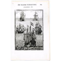
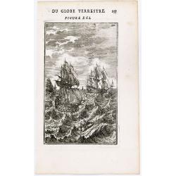
DU GLOBE TERRESTRE - Figure XC. 253
Finely engraved plate of various types of sailing ships.From the French text edition of Description d'Univers.. (5 volumes), 1683. By Allain Manneson Mallet (1630-1706), ...
Date: Paris, 1683
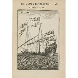
GALERE
Miniature view of a galley. From the French text edition of Description d'Univers.. (5 volumes), 1683. By Allain Manneson Mallet (1630-1706), a well travelled military en...
Date: Paris, 1683
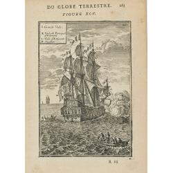
(Des Galeres - Shipping scene)
Miniature view of a vessel, showing the various types of sails. With key list in upper left corner.From the French text edition of Description d'Univers.. (5 volumes), 16...
Date: Paris, 1683
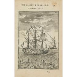
(Shipping)
Finely etched depiction of a vessel, with a lettered key. With explanatory text on verso.From the French text edition of Description d'Univers.. (5 volumes), 1683. By All...
Date: Paris, 1683

Saique batiment dont les turcs se servent. . .
A very decorative engraving of a Turkish vessel. From Mortier's famous maritime Atlas "Neptune François". Engraved by Jan van Vianen after a design by Henri Sb...
Date: Amsterdam, 1690
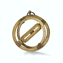
Very fine brass astronomical equinoctial ring with two brass circles.
Very fine brass astronomical equinoctial ring with two brass circles with engraved foliage decoration, signed "Jean-Baptiste-Nicolas Delure A Paris", on the han...
Date: Paris, undated, ca. 1690

Vaisseau du premier rang portant pavillon d'amiral.
Fine double-page engraved plate of a naval vessel, with the various parts of the ship numbered and identified. From Mortier's "Neptune François". From Mortier'...
Date: Amsterdam, 1695
Coupe d'une galère avec ses proportions - Quille d'une Galere sur le chantier.
Fine double-page engraved plate of a cutaway of a standard late 17th-century French galley with a detailed legend of parts (in French). Below is a representation of the k...
Date: Amsterdam, 1695
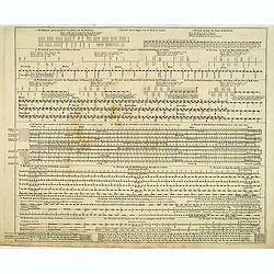
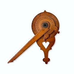
Echelle pour trouver les jours de la semaine. . . / Scale om de Dagen van de Week te vinden. . . / Scale to find the Days of the Week. . .
Fine engraved plate showing eight different scales with explications in French, Dutch and English.Scale om de dagen van de week, de verschietende feest-dagen, de maan-tyd...
Date: Amsterdam, 1695
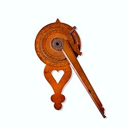
Nocturlabe in boxwood and brass.
Nocturlabe in boxwood and brass, the wheels maintained by a central nut presenting an annual calendar divided into months and days, an hour disc and a mobile alidade, the...
Date: England, ca. 1700
Wooden Nocturnal in boxwood and brass.
This exceptional nocturnal is made of boxwood and brass, the wheels maintained by a central nut, presents an annual calendar divided into months and days, an hour disc,...
Date: England, Thomas Cooper, dated 1701

Carro, che uà à vela Su le Piagge di Schevelingue.
Italian version of Prince Maurits' sailing carriage designed by Simon Stevin. The big sailing-carriage could seat 28 persons and could reach a speed of seven miles per ho...
Date: Venice, 1707
![[Manuscript chart on vellum of the Java Sea]](/uploads/cache/33613-250x250.jpg)
[Manuscript chart on vellum of the Java Sea]
One of the few manuscript charts on vellum in private hands, signed by Isaac de Graaf. ORIGINAL MANUSCRIPT MAP IN RED, GREEN AND BLACK INK showing the Java Sea centered o...
Date: Amsterdam, 1743
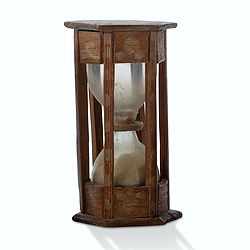
A ship's hour glass.
Maritime hourglass with blown glass bulbs, orange sand, junction ring covered with cord, the circular ebony frame with six turned baluster columns.The invention of the ho...
Date: The Netherlands, Germany, ca. 1750
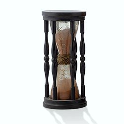
A ship's hour glass.
Maritime hourglass with blown glass bulbs, orange sand, junction ring covered with cord, the circular ebony frame with six turned baluster columns. The invention of the ...
Date: Germany, ca. 1750
Steel compass with a gilded radiating pattern.
Steel compass with a gilded radiating pattern.Provenance : Collection Henri-Claude Randier.
Date: ca. 1760
![Vue de l'Isle d'Ulietéa avec une double Pirogue et un hangar où les Insulaires retirent leurs bâtiments de mer. [Tome III Pl. 5.]](/uploads/cache/26106-250x250.jpg)
Vue de l'Isle d'Ulietéa avec une double Pirogue et un hangar où les Insulaires retirent leurs bâtiments de mer. [Tome III Pl. 5.]
A view on the Island of Ulietea, French Polynesia, of a dugout boat house and a beautifully engraved pirogue at sea. From the French edition of James Cook's first voyage ...
Date: Paris, 1773
![Vue de l'Isle d'Otahiti et de plusieurs Pirogues. [Tome II Pl. 11.]](/uploads/cache/26102-250x250.jpg)
Vue de l'Isle d'Otahiti et de plusieurs Pirogues. [Tome II Pl. 11.]
View of the Island of Tahiti and dugouts. From the French edition of James Cook's first voyage entitled Relation des voyages entrepris par ordre de sa Majesté Britanniqu...
Date: Paris, 1773

Mariner’s compass
Inverted compass called "snitch" in wood painted in imitation of tortoiseshell and brass, signed "Ing MANN Maker Water Street Liverpool".
Date: Liverpool, ca. 1785

A ship's hour glass
The element common to celestial position-finding, the calculation of speed for dead reckoning and even everyday life at sea is the time: hence ways of determining and kee...
Date: ca. 1790

Early 19th century magnetic dry card compass with wooden bowl,
Brass dry rose marine compass, in its mahogany case. The mariner's compass, which enabled mariners to know the direction in which they were sailing, has always been one o...
Date: ca. 1800
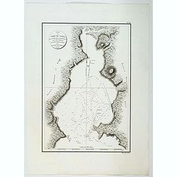
Plan du Port du Nord de la Baie de la Recherche.
A French maritime chart of the plan of the northern portion of Recherche Bay on the S.E. tip of Tasmania. The chart has some physical detail, outlining trees and hills, b...
Date: Paris, ca 1807
![Boats of the Friendly Islands. [together with] A Sailing Canoe of Otaheite.](/uploads/cache/30041-250x250.jpg)
Boats of the Friendly Islands. [together with] A Sailing Canoe of Otaheite.
Early view of Queen charlotte's sound, taken from "Views in the South Seas" being a very important and early views depicting scenes encountered while employed a...
Date: London, Boydell and Co., 1808
![[Pirogues in the bay of the voyage of the Resolution. The Marquesas Islands ].](/uploads/cache/26373-250x250.jpg)
[Pirogues in the bay of the voyage of the Resolution. The Marquesas Islands ].
Aquatint depicting men in pirogues in the Bay of the Resolution from the Marquesas Islands engraved by Biasioli. Plate N° 91. From Giulio Ferrario's work Le Costume Anci...
Date: Milan, 1827
![[Easter Island inhabitants ].](/uploads/cache/26375-250x250.jpg)
[Easter Island inhabitants ].
Aquatint depicting 2 portraits of Easter Island inhabitants and 2 men rowing in a pirogue. Engraved by Carlo Bottigella. Plate N° 88. From Giulio Ferrario's work Le Cost...
Date: Milan, 1827

Kaart van een gedeelte van de Noord Kust van Java en Straat Sunda van Tanjong Kaik tot den vierden hoek bij Anjer..
Very large and rare chart depicting Java's northern seacoast.Coastal profiles are present at the bottom of the map.The chart is prepared by B.H.Staring, J.A.G.Rietveld an...
Date: Amsterdam 1843-1844
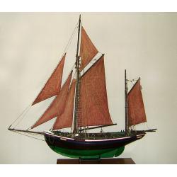
MAUREEN Shipping model of a fishing boat.
This type of fishing ships were used by the Dutch fisherman to fish for codfish, and even reached with them into the Canadian waters.Overall dimensions: 1400 x 100 x 230m...
Date: Netherlands, ca. 1850

AFFAIRES D'ORIENT Départ des Grenadiers de la Garde Anglaise, à bord du Steamer transatlantique l'Orenoco. . .
Beautiful lithography of the British steamboat "l'Orenoco" departure from Southampton in May 1854, with soldiers leaving for the Crimean War. After a design Lou...
Date: Paris, Lemercier, c.1860

New York Ferry Boat. (Bac à vapeur de New York).
A very decorative print showing the New York Ferry Boat "Fulton," published by Currier & Ives. The Ferry boat "Fulton" sails to the right. A singl...
Date: New York, ca. 1875
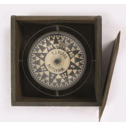
Compass.
A very nicely crafted sloop compass in original box. The compass is gimbaled and is executed in beautiful red copper. Made and signed by F.J. Kloos & Son of Rotterdam...
Date: Rotterdam, 1850-1875
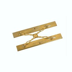
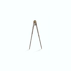
Marine parallel rulers in brass.
Very fine marine parallel rulers in brass. The parallel ruler is the oldest and most traditional way to measure and trace routes and bearings. The principle is simple: t...
Date: Paris, ca. 1880
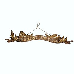
Transom of a ship in gilded carved wood bearing the inscription "DUMONT- DURVILLE"
Decorative transom sign in gilded carved wood bearing the inscription "DUMONT- DURVILLE" in a foliage environment. The transom usually kept the name of the ship...
Date: France, ca. 1880
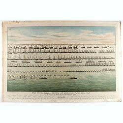
The Royal Naval review at Spithead, June 26th, 1897. In Honour of Her Majesty Queen Victoria's Diamond Jubilee.
A very decorative and large chromolithographed plate showing a line up of international vessels at Spithead, June 26th, 1897 In Honour of her Majesty Queen Victoria'a Dia...
Date: Portsea, ca. 1897
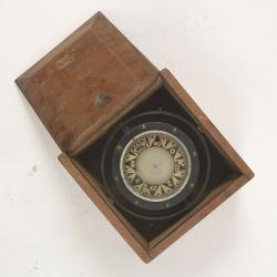
Compass.
A sloop compass in the original wooden box with lit. The compass with floating rose (Cardan system). Slung in gimbals, the east point is decorated and graduated in half ...
Date: c. 1890-1900
