Lidai Fenye Tu Gujin Renwu Tuji (歴代分野図古今人物図跡)
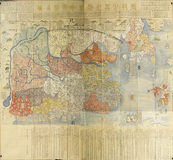
Title of the map: Lidai Fenye Tu Gujin Renwu Tuji (歴代分野図古今人物図跡)
Signed and dated lower left: Lu Junhan, Beijing (北京), dated: Kangxi, [康熙 18], year of the mutton, Kangxi 18, 1679
Size: 199 x 212 cm. Fully manuscript, hand-coloured on Mulberry paper.
The map contains more than two thousand annotations. Probably made on Kyūshū (Japan) in the late 18th or first half of the 19th century.
Sold
 This manuscript map is, in many ways, unique, and a complete study has not yet been completed. The artist who made this grand-scale manuscript map, which is quite handsome and colorful, combined three different sources to create a map showing China, Korea, and Kyūshū.
China
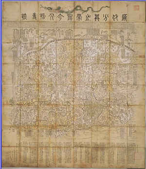
As for China, this part has been copied from a printed map also signed Lu Junhan and dated 1679, measuring 136x124cm. in size.
The printed Lu Junhan map is now known in only one copy (Bodleian Library, Oxford), and it depicts Ming-dynasty China at the center and shows its two imperial capitals,
Beijing and Nanjing, thirteen provinces, the Great Wall, and significant mountains and rivers.
On the map, the texts also describe the relics of persons and events, past and present. The text at the bottom of the map describes the 2 capitals and 13 provinces of the Ming dynasty, including their names, numbers of families and population, the production of rice, wheat, raw and processed silk, cotton, copper, horse fodder and salt, etc., as well as the distances between provinces. According to Li Xiaocong of the University of Peking, Department of History, who describes the map in his book "Catalog of pre-1900 Chinese maps seen in Europe, (Beijing International Culture Press, 1996), pp.158-159, the map by Lu Junhan of 1679 was influenced by Cao Junyi’s and Wang Junfu, both depicting the borders of the Ming Empire.
There is a Japanese copy with a new title "Lidai fenye zhijie Gujin ren wu Shiji", 歴代分野之圖古今人物事跡 made by Miyagawa Choshun and engraved by Shoda Masahide and Sakaguchi Kazuyoshi, printed in Japan in 1750, and published by the Edo publisher Suharaya Mohei (alternative reading: Suharaya Mohei ), size 170x200cm. (Beans 1750.1)
In the University of British Columbia Library - Rare Books and Special Collections - Japanese Maps of the Tokugawa Era section, a 1754 edition (size 160x179cm) is kept.
Korea.
Until now, we have not been able to tell from which map Korea is possibly copied
Kyūshū
The artist added quite a detailed depiction of the Island of Kyūshū, the Southernmost large island of the Japanese Empire. On Chinese maps, Japan was often rendered only as a circle with a name, or was omitted entirely. That was because Japan was not a tributary state of China. On the original map by Lu Junhan, Japan and other islands are not shown, but boxes with Chinese notes indicating their existence and location are included.
According to Prof. Wolfgang Michel:
Only a few high-ranking Buddhist priests fled China in the wake of the Ming defeat and were allowed to settle in Japan. It was easy to come to Nagasaki, stay there for a while, and do trade. But entering the country was another thing.
This said, I agree that this map combines a Chinese map and a Japanese one.
The Japanese part shows Kyūshū with Iki, Tsushima in the north, and Tanegashima, Yukushima in the South. There should have been a few more Southern islands annexed by the Satsuma clan in 1609, but in some cases Japanese mappers failed to do so.
The explanation about Japan Ribenguo /Nihonkoku is written from a Chinese perspective. According to the last line of the text (left hand side below) the author seems to be once again Lu Shi-an in Beijin (北京呂君翰撰).
At the end of the text on Kyūshū, we find a hint (六十餘洲内分九州図) that the Kyushu map was part of a greater Japan map (六十餘洲=日本全国).
The Kyushu map is indeed of Japanese origin. There are several names or parts of names written in Katakana syllables. The character 崎 (saki) is often written as サキ. The name of Nagoya Castle (built by Hideyoshi for the invasion of Korea) is written entirely in Katakana and marked with a triangle.
The model might be an early Edo map, or even date to the era shortly before Ieyasu came to power. Chikuzen shows Akizuki as a central place marked with a red square, whereas Fukuoka is only given its name.
In the 17th century, it should be the other way round. Maybe I can find out more about the date by checking the information of rice income in each province. But for this, I need a little bit more time.
* Considering the situation during the latter half of the 17th century, I am a little bit skeptical about the movement of people. There were a lot of restrictions in place in Japan, Korea and China. The transmission of a Japanese map to China or Korea is more readily accepted.
* Someone living in 17th-century Kyushu should have come to more actual results.
* Someone living in Korea was interested in China and Japan as well, no doubt. Korean diplomatic embassies traveled to Edo each time a new shogun came to power.
* Someone living in China might be interested in Japan if he is doing trade. But in that case, Nagasaki should have received more attention."
The above information was kindly provided by Prof. Wolfgang Michel, Professor Emeritus at Kyushu University, Japan.
Whatever the situation, our map is extremely rare, if not unique.
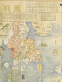 Detail of Korea |
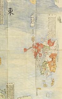 Detail of Kyūshū ! |
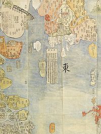 Southern tip of Korea, with panel of explanation. |
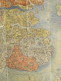 Detail of South East China |
Chinese Cartography.
Some Features of Chinese Cartography
From ancient times, maps have served a variety of purposes in China. Many were designed as practical educational tools for scholar-officials, to guide, instruct and edify in times of both peace and war. They were also employed as a concrete means of asserting the emperor's territorial claims, whether local, empire-wide, or world-wide. Maps became symbolic tokens of exchange in China's domestic and foreign relations, and were even used to depict a perceived link between the realms of Heaven and Earth. Significantly, they also provided a means by which viewers could take "spiritual" journeys to distant lands--the cartographic equivalent of "traveling [through a landscape painting] while remaining at rest [woyou]".
Chinese mapmakers tended to be broadly gauged scholars and artists rather than narrow technicians. Until the late nineteenth century there were no professional or specialist cartographers as such in China. The scholars who created maps saw their productions as part of a larger intellectual and cultural enterprise--one that embraced not only science (especially astronomy and geography) but also history, philosophy, religion, art, literature, and religion (including divination). "History" was an especially prominent value in Chinese maps. Many cartographic collections, and even individual maps, bear titles indicating that they concern the relationship between the "past and present" (gujin) or between successive dynastic periods (lidai). In other words, time and space remained closely connected in imperial China.
On the whole, explicitly religious maps seem to have been less popular in the Central Kingdom than in other parts of Asia, such as Burma, Korea, Japan and Tibet. Overall, Chinese cartographers treated large-scale space, including the world itself, as essentially flat. Although mathematical astronomers used ecliptic and equatorial coordinates in their celestial mapping, cartographers saw no need to project them onto the Earth. As a result, they "simply acted as of they were transferring points from a very large flat surface to a smaller one." At the same time, however, Chinese mapmakers often employed variable perspective and variable scale. Thus, for example, mountains might be drawn in elevation while rivers would appear in plane. Moreover, the size of objects relative to one another, as well as their distance from one another, were usually dictated not by their actual dimensions or by geometrical perspective but rather by the specific purposes for which the map was produced. Heavy annotation provided valuable information that might otherwise have been expressed by graphic images of scale.
Chinese maps often devote more space to the written text than to the actual image. Although the tendency for historians of cartography has been to denigrate heavily annotated maps in favor of more "representational" ones, there is no intrinsic reason for doing so. It was not, after all, lack of skill or "backwardness" that determined the nature of traditional Chinese cartography. In China, for cultural reasons, the written word, rather than visual images, remained the primary source of representational authority. Cartographic texts in China commonly provided technical data concerning roads, waterways, landmarks, distances, and so forth. But they also supplied important cultural information.
The textual emphasis of traditional Chinese cartography did not in any way undermine the aesthetic appeal of maps. On the contrary, inscriptions often enhanced it. In contrast to the development of cartography in Europe, where manuscript maps became rather rare following the spread of copper engraving in the late fifteenth century, manuscript maps continued to be produced in great numbers in China. These documents, like landscape paintings, were tastefully shaded and often complemented by substantial amounts of calligraphy--sometimes even poetry. Printed maps could also be extraordinarily beautiful, with handsome, well-cut cartouches and carefully colored natural features. Neither type of map could be considered true art; however, both lacked the qualities of "life force" (qi) and "kinesthetic power" (shi) that distinguish artistic creativity from mere craftsmanship.
During the Kangxi period (16662-1722), the Jesuits were given an opportunity to demonstrate the virtues of their cartographic techniques. They accompanied the emperor on northern expeditions and taught him how to take astronomical measurements and measure elevations and distances. The Kangxi Emperor had a deep interest in mathematics and in learning geography. The lack of uniform practices of representation among Chinese cartographers hampered the production of a comprehensive geographic record such as the emperor envisioned. In 1698, the Jesuit missionary Dominique Parrenin (1665-1759) examined various provincial maps and found errors in the locations of prefectures, counties, and cities.
Nagasaki
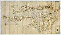 The fact that Japan was omitted on Chinese maps did not imply that they did not visit Japan, or better said, Nagasaki on the Island of Kyūshū. Only a few high-ranking Buddhist priests fled China in the wake of the Ming defeat (1644) and were allowed to settle in Japan. It was easy to come to Nagasaki, stay there for a while, and do trade. But entering the country was another thing. Chinese traders were allowed to Nagasaki too, but like the Dutch, they had to stay in enclosed quarters called Tojinyashiki (Chinese residence).
In 1543 Portuguese traders were the first to land in Japan, on Tanegashima. Six years later, the Jesuit missionary Francis Xavier landed in Kagoshima. Between 1549 and the 1630s, various foreigners landed at various ports in Japan. However, Nagasaki was the only place in Japan that was open to foreigners (Portuguese, Chinese, and later the Dutch) during nearly 300 years of isolation between the early-1600s and the late-1800s.
Used first by the Portuguese, beginning in 1571, and later by the Dutch. Nagasaki was the point of entry for Christianity, Christian culture, and Western technologies such as shipbuilding, mining, printing, photography, medicine, and railway transportation.
After 1639, all Westerners were expelled except the Dutch belonging to the VOC. From 1641 onward, they were confined to Dejima, a 120-by-75-meter artificial island built in 1634 and linked to the mainland by a small bridge, guarded on both sides, with a gate on the Dutch side. One of its most famous inhabitants was Dr. Philipp Franz Balthasar von Siebold.
17th century Nagasaki: Nagasaki was also an important Christian center.
For a time, it was known as "Small Rome in Japan." In 1597, 26 Catholics, including
six foreigners and a 12-year-old Japanese boy, were crucified as a result of a
decree against Christianity passed by Toyotomi Hideyoshi. All 26 became saints.
Dejima is no longer an island, but it does contain a few old relics (a Dutch sundial and a couple of European cannons) and has more old European-style buildings than anywhere else in Japan.
Further Reading
Harley, J. B.,& Woodward,D. (Eds.). (1994). The history of cartography: Vol. 2, Book 2. Cartography in the traditional East and Southeast Asian societies. Chicago: University of Chicago Press.
Hostetler, L. (2001). Qing colonial enterprise: Ethnography and cartography in early modern China. Chicago: University of Chicago Press.
Howland, D. R. (1996). Borders of Chinese civilization: Geography and history at empire’s end. Durham, NC: Duke University Press.
Leonard, J. K. (1984).Wei Yuan and China’s rediscovery of the maritime world. Cambridge, MA: Harvard University Press.
Smith, R. J. (1996). Chinese maps: Images of all under heaven. Oxford, UK: Oxford University Press.
Smith,R. J. (1998). Mapping China’s world: Cultural cartography in late imperial times. In Y.Wen-hsin (Ed.), Landscape, culture and power in Chinese society (pp. 52–109). Berkeley and Los Angeles: University of California, Center for East Asian Studies.
Yamashita, K. (1996). Japanese maps of the Edo period. Tokyo: Kashiwashobo.
Yee, C. D. K. (1996). Space and place: Mapmaking east and west. Annapolis, MD: St. John’s College.
Li Xiaocong (1996) "Catalog of pre-1900 Chinese maps seen in Europe, Beijing International Culture Press.
