Search Listings matching "silk"
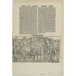
Constatinopolis.
Panoramic town-view of Constantinople (Istanbul). Woodcut published in the so-called pirate edition of the "small Schedel" in Augsburg, 1497, Latin edition. Ori...
Date: Augsburg, Johann Schönsperger. 1497
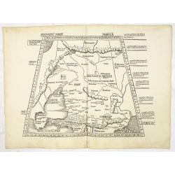
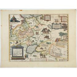
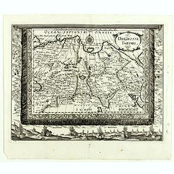
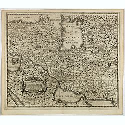
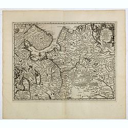
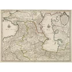
Secunda Asiae Tabula (Ukraine and Russia)
Woodblock printed a large-format Ptolemaic map showing Russia, Ukraine, and the Black Sea region. From the 1513 edition of Waldseemüller's Geographia.One of the earliest ...
Date: Strasburg, 1513
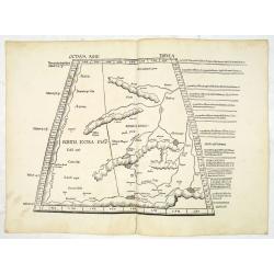
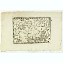
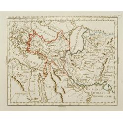
![Septima Asie Tabvla. |Walsseemüller's map of Central Asia and the Silk Road]](/uploads/cache/62137-250x250.jpg)
Septima Asie Tabvla. |Walsseemüller's map of Central Asia and the Silk Road]
Trapezoidal woodcut map showing the area east of the Sarygamysh Lake, about midway between the Caspian Sea and the (former) Aral Sea. It is one of the earliest obtainabl...
Date: Strasburg, J. Schott, 1513
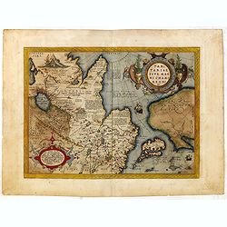
Octava Asie Tabula.
PTOLEMY, C. / WALDSEEMÜLLER, M. - The Silk Road Area.
Date: Strasburg, 1513
Tabula X. Asiae hae sunt e cognitis totius orbis.
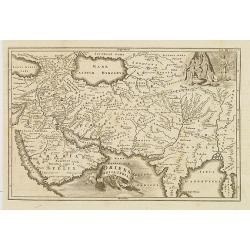
This is the earliest printed representation of India west of the Ganges River in Ptolemy's time. It is an essential map of southwestern Asia, including Persia, Afghanista...
Date: Lyons, M. Servetus, 1525
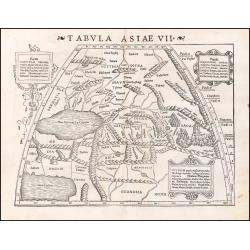
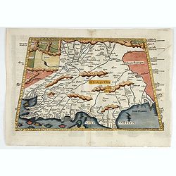
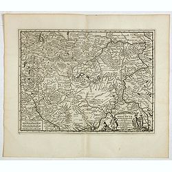
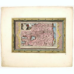
Tabula Asiae VII.
Attractive woodblock map, depicting the Caspian Sea, Black Sea and the Persian Gulf, extending to the Imaus Mountains. according to Ptolemy. In the center of the map is...
Date: Basle, 1542
![Sevilla, Hispalis ... [on sheet with] Cadiz [and] Malaga.](/uploads/cache/33642-250x250.jpg)
Sevilla, Hispalis ... [on sheet with] Cadiz [and] Malaga.
Very desirable and early view of Sevilla, Cadiz and Malaga, with the Roman and Moorish citadels on the hills in the background. "In the upper part Sevilla, showing ...
- $500 / ≈ €439
Date: Cologne, (1572) 1577
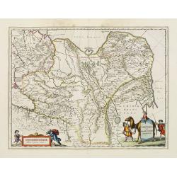
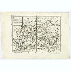
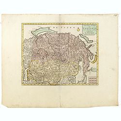
Tartariae sive Magni Chami Imperium.
This is a very early depiction of the northern Pacific, with the first mapping of the Northwest Coast of America and probably the first map to name California 'C. Califor...
Date: Antwerp, c. 1590
Russiae, Moscoviae et Tartariae Descriptio.
Engraved by Frans Hogenberg from an original of 1562 by Anthony Jenkinson of the English Muscovy Company. The many vignettes are based on the reports of Marco Polo's expl...
Date: Antwerp, 1598

Tartaria.
Published in Hondius' editions of the Mercator Atlas from 1606 onwards, China, Korea, and the northern Pacific coast of America are shown as two continents separated by t...
Date: Amsterdam, 1633
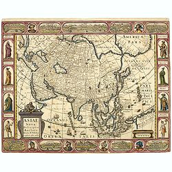
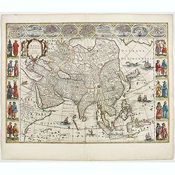
Asiae Nova Descriptio.
Final State of Pieter Van Den Keere's Rare Map of Asia -- The first map of Asia to include decorative panels. Published by N.J.Visscher and engraved by Abraham Goos, embe...
Date: Amsterdam, 1636
Asia noviter delineata. . .
From 1633 the members of the Blaeu family were official cartographers to the United East India Company and, as such, had access to the most up-to-date cartographic inform...
Date: Amsterdam, 1644
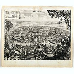
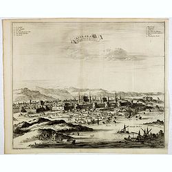
Isfahan.
An early of Isfahan in central Iran,. From the rare first edition "Offt begehrte Beschreibung der newen orientalischen Rejse, so durch Gelegenheit einer Holsteinisc...
- $250 / ≈ €220
Date: Schleßwig, Zur Glocken, 1647
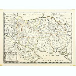
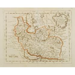
Description de l'Empire du Sophi des Perses tiree en partie de l'Arabe de Nubie, et en partie de plusieurs et diverses Relations.
The map of the Empire of Persia is shown to extend from Baghdad almost to the present-day borders of India. Including part of Saudi Arabia and Oman. Including "Golfe...
Date: Paris, 1650
Tartaria sive Magni Chami imperium.
This is a detailed and decorative map of the Tartary and northern part of China, including the Chinese Great Wall, the Caspian Sea, and the Volga River east as far as the...
- $700 / ≈ €615
Date: Amsterdam, 1658
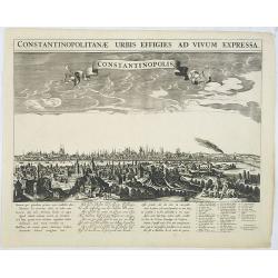
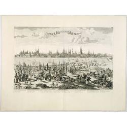
Constantinopolitanae urbis effigies ad vivum expressa.
A rare panoramic town-view of Istanbul with over the whole length of the lower part 3 columns of poems in Latin, Dutch and French and a numbered key 1-29 to the principal...
Date: Amsterdam, 1660
![[Printed on silk] Nova Totius Americae Sive Novi Orbis Tabula, Auct. Hugo Allardt.](/uploads/cache/48420-250x250.jpg)
[Printed on silk] Nova Totius Americae Sive Novi Orbis Tabula, Auct. Hugo Allardt.
Hugo Allard’s ca. 1661 map of the Americas, showing California as an island printed on silk. This separately issued map printed on paper is quite rare on the market. The...
Date: Amsterdam, 1661
Die Grosse Tartari.
Rare map showing Siberia, Korea, with part of the Caspian Sea to the West, as well as India and North Russia. The title is in an oval cartouche in the upper right cornerT...
- $1000 / ≈ €879
Date: Augsburg, 1689
A New Map of Great Tartary and China with the adjoining parts of Asia
Two insets show the land to the northeast of China, according to Jesuit information. The map stretches from northern Russia and Nova Zemlya in the northwest to Formosa in...
Date: Oxford, 1700
A New Map of Great Tartary and China with the adjoining parts of Asia…
Two insets show the land to the northeast of China, according to Jesuit information. The map stretches from northern Russia and Nova Zemlya in the northwest to Formosa in...
Date: Oxford, 1700
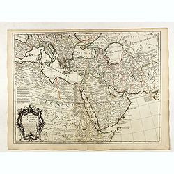
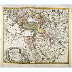
Carte de la Turquie de l'Arabie et de la Perse.
Very rare state with the address : Chez l’Auteur, Rue des Canettes prez St. Sulpice. Avec Privilège, 1701". This early state with "rue des Canettes" imprin...
Date: Paris, 1701
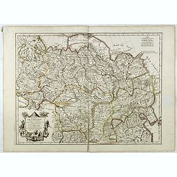
Carte de Tartarie.
Covering north east Asia, Tibet, Korea and part of "Terre d'Eso". Nova Zembla joined with the mainland.With good detail in Korea, several cities a labeled: Cha...
- $500 / ≈ €439
Date: Paris, 1706
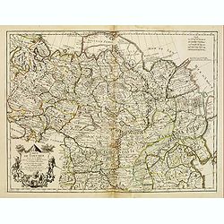
Carte de Tartarie.
Rare first edition "Chez l'Auteur Rue des Canettes préz de St. Sulpice". The "Rue des Canettes" address appears on the original versions of maps dated...
Date: Paris, 1706
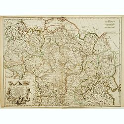
Carte de Tartarie..
Uncommon Amsterdam edition covering north east Asia, Korea and part of "Terre d'Eso". Nova Zembla joined with the mainland. Showing the Caspian Sea with present...
Date: Amsterdam, 1706
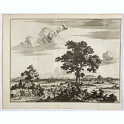
La grande & belle ville de Kaschan, en Perse. (Kashan in Iran)
1719 VAN DER AA, P. - A view of Kashan in Iran, at the eastern foot of the Central Iranian Range, on the once important Silk-Road caravan route.
- $285 / ≈ €250
Date: Leiden, 1719
Saba, ville en Perse.
Decorative view of Sabā / Dakān Sorkh) which is a village in Vahdatiyeh Rural District in present-day Iran.In the foreground are camels and horses. This well-executed eng...
Date: Leiden, 1719
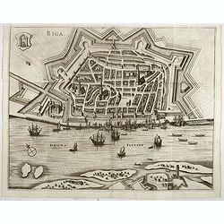
Riga.
Decorative view of Riga. This well executed engraving was published in 1729 and 1727 by Pieter van der AA, in Leiden in "Les Voyages tres-curieux et tres-renommez fa...
Date: Leiden, 1719
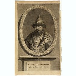
Michael Federowits . . .
Portrait of Tsar Michail Feodorovich (1596-1645). Engraving by Jacob Christopher Sartorius (1694-1737) engraver, active in Nuremberg. This well executed engraving was pub...
- $75 / ≈ €66
Date: Leiden, 1719
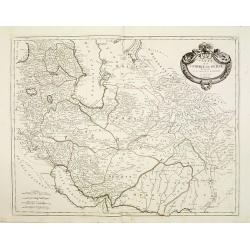
Carte la plus nouvelle et plus exacte du royaume de Perse . . .
This is a decorative map of Persia and Central Asia. It has very good details of the region east of the Caspian Sea, showing modern-day Uzbekistan. The region is labeled ...
- $400 / ≈ €352
Date: Leiden, 1719
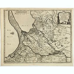
Les trois Iles, appellées en Allemand Werders, ou sont les Territoires de Dantzic, Marienbourg et Elbing dans la Prusse Royale avec les Côtes de la Mer Baltique, suivant la description de Olaus Jean Gotho...
Decorative regional map including the town of Danzig and the region south of it. East to the top. This well-executed engraving was published in 1729 and 1727 by Pieter va...
- $450 / ≈ €395
Date: Leiden, 1719
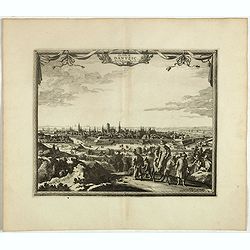
Elbing. (Elblag in Northern Poland)
Decorative view of the town of Elblag in Northern Poland. This well executed engraving was published in 1729 and 1727 by Pieter van der AA, in Leiden in "Les Voyages...
- $400 / ≈ €352
Date: Leiden, 1719
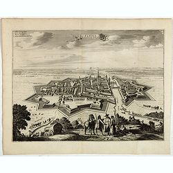
La ville de Dantzic dans la Prusse Royale.
Decorative view of Danzig. This well executed engraving was published in 1719 by Pieter van der AA, in Leiden in "Les Voyages tres-curieux et tres-renommez faits en ...
- $400 / ≈ €352
Date: Leiden, 1719
La Moscovie septentrionale . . .
Decorative view of area north of Moscow. This well-executed engraving was published in 1729 and 1727 by Pieter van der AA, in Leiden in "Les Voyages tres-curieux et ...
- $250 / ≈ €220
Date: Leiden, 1719
La Moscovie meridionale . . .
Decorative map centred on Moscow. This well executed engraving was published in 1729 and 1727 by Pieter van der AA, in Leiden in "Les Voyages tres-curieux et tres-re...
- $300 / ≈ €264
Date: Leiden, 1719
Astrakan, ville capitale du royaume du meme nom, en Moscovie. (Astrakhan)
Decorative view of Astrakhan. Astrakhan is where Europe ends and Central Asia begins. Its position on the Caspian Sea has ensured a long history as an important trading h...
- $300 / ≈ €264
Date: Leiden, 1719
![Nouvelle carte de la province de Kilan en Persie . . . (Iran]](/uploads/cache/39437-250x250.jpg)
Nouvelle carte de la province de Kilan en Persie . . . (Iran]
Decorative map of southern part of the Caspian Sea in Northern Iran. This well executed engraving was published in 1729 and 1727 by Pieter van der AA, in Leiden in "...
- $300 / ≈ €264
Date: Leiden, 1719
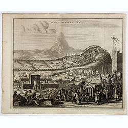
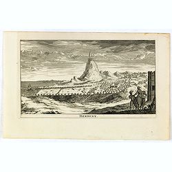
La ville de Berbendt, en Perse.
Decorative view of Derbendt - Derbent, a city in the Republic of Dagestan, Russia, located on the Caspian Sea, north of the Azerbaijani border. It is the southernmost cit...
- $350 / ≈ €308
Date: Leiden, 1719

Carte des Indes, de la Chine & des Isles de Sumatra, Java &c..
This fine and quite detailed general map extends from northern Japan to Timor and from India to New Guinea.There are very good details of towns and trade routes in modern...
Date: Amsterdam, 1720

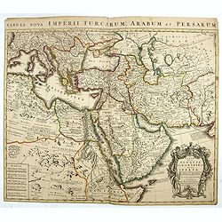
A Map of Turky, Arabia And Persia. Corrected from the latest Travels. . .
FIRST EDITION - Fine Turkish Empire map centered on Saudi Arabia, Cyprus and the Mediterranean Sea. Dated 1711, "Sold by John Senex at the Globe aga inst St. Dunstan...
- $1750 / ≈ €1538
Date: London, 1721
Carte des Pays Voisins de la Mer Caspiene dressee pour l' usage du Roy. . .
The map shows the area east of the Caspian Sea, including parts of Kazakhstan, Turkmenistan, Uzbekistan, and northern Iran. The area eastward from the Caspian is marked '...
- $750 / ≈ €659
Date: Paris, 1723
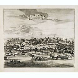
Zariza, petite ville des Moscovites, dans le royaume d'astracan, sur le bord du Wolga.
Decorative view of the town of Volgograd (Zarizyn) on the Volga River. This well executed engraving was published in 1729 and 1727 by Pieter van der AA, in Leiden in &quo...
Date: Leiden, 1719-1727
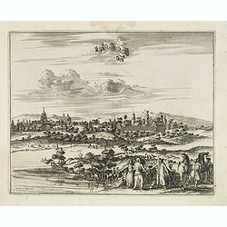
Cassimogorod ville de la Tartarie Moscovite.
Decorative view of the town of Kasimov on the Oka River, east from Moscow and south from Murom near the northern shore of the Caspian Sea. The city is seen from across th...
Date: Leiden, 1719-1727
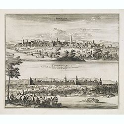
Soratof, ville de Tartarie Moscovite. / Tzornogar, Petite Ville des Moscovites, dans le Royaume d'Astracan, sur le bord du Volga.
Decorative engraving of two panoramic views in top Saratov with in the foreground the Volga River and in bottom a view of Chernyy Yar on the Volga River. This well execut...
Date: Leiden, 1719-1727
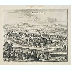
La Ville de Bagdad, dans la Turquie.
Decorative view of the town of Bagdad. This well executed engraving was published in 1729 and 1727 by Pieter van der AA, in Leiden in "Voyages tres-curieux et tres-r...
Date: Leiden, 1719-1727
![[Printed on silk] Nieuw Wassende Graaden Paskaart Vertoonende alle de bekende Zeekusten en Landen op den geheelen Aard Boodem of Werelt door Gerard van Keulen. . .](/uploads/cache/31640-250x250.jpg)
[Printed on silk] Nieuw Wassende Graaden Paskaart Vertoonende alle de bekende Zeekusten en Landen op den geheelen Aard Boodem of Werelt door Gerard van Keulen. . .
A very scarce and beautiful chart on Mercator's projection printed on silk. With the name of Gerard van Keulen and the privilege. The map shows great interior detail, inc...
Date: Amsterdam, 1728
Historic Map - Naaukeurige Kaart Van Tartaryen, Soo als dat door W De Rubruquis doorreyst.
This attractive map published by Pieter van der Aa, shows Tartary abd the ancient Silk Road region. The map shows the track of William of Rubruck (Willem van Rubroeck or ...
Date: Amsterdam, 1713-1729
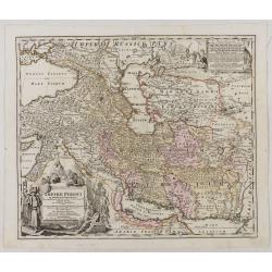
Imperii Persici in omnes suas Provincias . . . Exacte Divisi Nova Tabula Geographica. . .
Showing the eastern part of Turkey and Cyprus, Palestine, Persian Gulf, including Gulf of Oman, Caspian Sea, Iran and the north-west territories of India.Embellished with...
Date: Ausburg, 1730
Great Tartary, with the tract of the Moscovite Ambassador's Travels from Moscow to Pekin in China.
An interesting map illustrating the route taken by the Russian Ambassador on his travels east to Beijing. Shows the Great Wall, "Somer Houses" and "parts u...
Date: London, 1732
Oriens, Persia, India etc.
Uncommon map of Persia, Armenia, Arabian Peninsular and part of India. Prepared by Christoph Cellarius (1638-1707). From Geographia Antiqua...
Date: Leipzig, Gledisch, 1732
Derbent.
View of Derbent, the southernmost city in Russia from a scarce series of city views by Daniel de la Feuille (1640-1709). Engraving shows the ancient fortress and ruins of...
- $100 / ≈ €88
Date: Amsterdam, 1734
Nova Maris Caspii et Regions Usbeck. . .
This is the first printed map specifically of the Uzbek region. It shows the area around the Caspian Sea and northern Iran. The area eastward from the Caspian is marked '...
Date: Nuremberg, 1735
Imperium Turcicum in Europa, Asia et Africa Regiones proprias, tributarias, clientelares sicut et omnes eusdem Beglirbegatus seu Præfecturas Generales exhibens. . .
Johann Baptist Homann's well-engraved map of the Ottoman Empire centered on Cyprus. With good detail in the Arabian Peninsular. In the lower left, a decorative title cart...
- $500 / ≈ €439
Date: Nurnberg, 1737

Carte la plus generale et qui comprend la Chine, la Tartarie chinoise et le Thibet. . .
It has a quite elaborate pictorial cartouche engraved by G. Kondet. It is a very detailed map of China, Tibet, and Korea.In the upper left corner is very good details of ...
Date: The Hague, 1737
A Map of Western Tartary Drawn from the Survey of the Jesuits and Mr. Kyrillow's Map of the Russian Empire.
Uncommon map of the Gobi Desert and the eastern portion of the Silk Route region by Thomas Kitchin. Covers from Lake Baikal in the north as far south as Beijing, east to ...
- $110 / ≈ €97
Date: London, 1745-1747
Nieuwe kaart van Tartarie.
A map of Tartary, Korea and part of Japan. The map is most notable for the confusion between Kamchatka and Iesso.There are very good details of towns and trade routes in ...
Date: Amsterdam, 1750
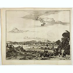
Constantinople ville de Romanie et capitale de l'Empire des Turcs.
A very decorative and extremely rare of Istanbul, including a numbered legend in lower part. Published by Jacques Chéreau, (1688 - 1776). Engraved by Aveline and first p...
Date: Paris, ca.1750
![[Set of 3 optical prints] Vue du Pallais du l'Empereur de Perse avec la Mosquée, ou Eglise a Ispahan.](/uploads/cache/49123-250x250.jpg)
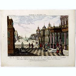
[Set of 3 optical prints] Vue du Pallais du l'Empereur de Perse avec la Mosquée, ou Eglise a Ispahan.
An optical print of the court of the Persian Emperor. Engraved by F.X. Habermann (1721-1796). The Academie Imperiale was a well-known publisher of optical prints establis...
Date: Augsburg, 1750
Vue du Pallais du l'Empereur de Perse avec la Mosquée, ou Eglise a Ispahan.
An optical print of the court of the Persian Emperor. Engraved by F.X. Habermann (1721-1796). The Academie Imperiale was a well-known publisher of optical prints, establi...
- $300 / ≈ €264
Date: Augsburg, 1750
Carte de la Turquie de L'Arabie et de la Perse.
This is the Amsterdam issue of De L'Isle's map of the Turkish Empire and Arabian Peninsula. It includes the Turkish Empire, the Mediterranean, Central Asia, and parts of ...
Date: Amsterdam, 1751
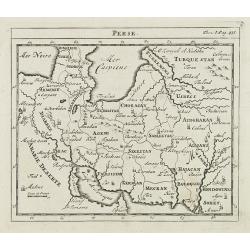
Perse.
Scarce small map of Persia based on cartography of Guillaume Delisle (. Published in "Nouveau traité de geographie par M ", published by La veuve Lottin & B...
Date: Paris, P.G. Le Mercier, 1752
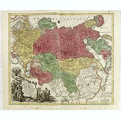
Spatiosissimum Imperium Russiae Magnae juxta recentissimas Observationes Mappa Geographica . . .
This is a decorative map of greater Russia, extending from Livonia in the west to Kamchatka, China, Tibet, Taiwan, Korea, and part of Japan in the east. To the south, it ...
- $1300 / ≈ €1142
Date: Augsburg, 1757
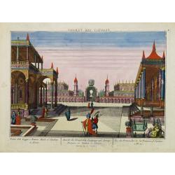
Vue des Promenades et les Fontaines d'Ispahan.
Carmine was a well-known publisher of optical prints, established in Augsburg.Isfahan was once one of Central Asia's largest and most important cities, at the crossroads ...
Date: Augsburg 1770
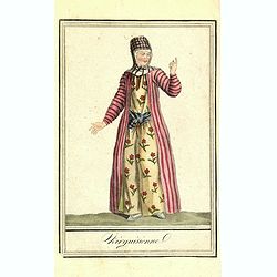
![Une Kirguisiene par devant. [together with] Une Kirguisienne par derriere.](/uploads/cache/32991-250x250.jpg)
Une Kirguisiene par devant. [together with] Une Kirguisienne par derriere.
1780 - ROTH, Ch. M. Two costume plates showing natives of Kyrgyzstan
Date: St. Petersbourg, C.G. Müller, 1776-1780
Alexandri Magni Imperium et Expeditio per Africam et potissimum per Aslam.
Rare map of the Empire of Alexander the Great, prepared by J.B.Nolin and published by Monhare for his Atlas Général a l'usage des colleges et maisons d'education.. Center...
Date: Paris, 1783
Le Royaume de Perse suivant les nouvelles observations Par J.B.Nolin.
This is a rare map of Persia with modern-day Uzbekistan to the north. The region is labeled as "Grande Tartarie" and "Pays des Usbeks." Bocara (Bukhar...
- $300 / ≈ €264
Date: Paris, 1783
Carte de l'Empire de Perse...
Finely and crisply engraved map of the Persian Empire during the 18th century. It shows the Caspian Sea in the north to the Persian Gulf in the south, and from Armenia in...
Date: Venice, 1779 - 1784

L'Asie divisée en ses principaux Etats..
A finely and crisply engraved map of Asia is decorated with an ornamental title cartouche in the lower-left corner.There are very good details of towns in modern-day Uzbe...
Date: Venice, 1776 - 1784
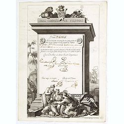
A scarce Real Compañia de Filipinas 250 Pesos deed issued in 1785.
A scarce Real Compañia de Filipinas 250 Pesos deed issued in 1785. Share nº 24665, hand signed by several company officials.Engraved by Fernando Selma (1752-1810) after t...
Date: Spain, 1785

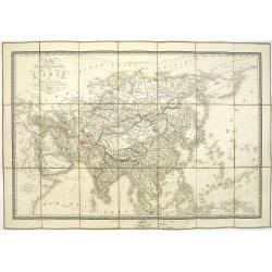
Carte d'Asie divisée en ses principaux Etats.
Uncommon and decorative "carte à figures" - wall map, prepared by Clouet, with superb decoration, including a wonderful rococo border with 20 decorative vignett...
Date: Paris, Mondhare, 1787
![[Asia and part of Australia]](/uploads/cache/26453-250x250.jpg)
[Asia and part of Australia]
An engraved map of Asia shows an oversized Japan and part of Australia, called Neu Holland. To the east of the Caspian Sea, we see the area of present-day Uzbekistan and ...
- $450 / ≈ €395
Date: Tübingen, Heerbrandt, 1790
Kirguisienne.
Originally hand-colored mezzotint from 'Costumes civils actuels de tous les peuples connus', showing a native of Kyrgyzstan, a Central Asian country along the Silk Road, ...
- $25 / ≈ €22
Date: Paris,1801-1806
Carte d'Asie.
Fine map of Asia, with an interesting representation of Japan, Hokkaido, Sakhalin Island, Kamchatka, and Korea. Engraved by Alexandre Blondeau, who also worked for Depôt ...
- $175 / ≈ €154
Date: Paris, c. 1810

Voyage of his majesty’s ship Alceste, along the Coast of Corea, to the island of Lewchew, with an account of her subsequent shipwreck, by John M’LEOD. Surgeon of the Alceste.
The second and best edition, with a frontispiece portrait of Captain Maxwell and five fine hand-colored aquatint plates, including a plate not present in the first editio...
Date: London, John Murray, 1818
Tablaeu géographique statistique &C. de l'empire Russe actuel en Europe et en Asie avec ses aquisitions graduelles et caractérisées.
Map showing the extension of the Russian Empire at the beginning of the 19th century. Several letterpress notations are present on the map.Surrounding letterpress explana...
Date: Paris, Paul Renouard, 1828
Perse Afghanistan et Balouchistan . . .
Detailed map of Irak and Iran, prepared by A. H. Basset, rue Saint-Jacques, no. 64, Paris and published in Atlas classique et Universel de Géographie . . . .The top three...
Date: Paris, A.H. Basset, 1828

A Chinese official with a ceremonial hat, holding a fan and a silk purse.
A colored wood block print of a Chinese official with a ceremonial hat, holding a fan and a silk purse.
Date: Nagasaki, c. 1830
Carte physique et politique de l'Asie. Publiée pour la première fois en 1822 par J. GOUJON. Revue et augmentée par l'éditeur d'après de nouveaux matériaux.
This is a detailed map of Asie. It provides very good details of towns in modern-day Uzbekistan. The region is labeled as "Usbecs." The important cities on the...
Date: Paris, J. Goujon et J. Andriveau, 1837
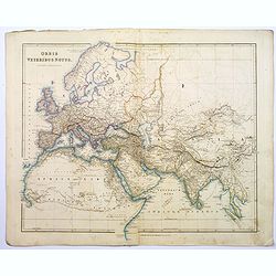
Orbis Veteribus Notus.
This is a detailed steel-engraved map of the ancient world, stretching from Europe eastwards to the Black Sea and beyond, southwards through northern Africa, Arabia, Indi...
Date: London, 1839
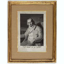
(Portrait of Joseph-Marie Jacquard).
A rare woven silk portrait of Joseph-Marie Jacquard after Bonnefonds, completed on the Jacquard punched-card loom. Woven by Carquillat in the silk factory of Didier Petit...
Date: France, ca. 1840
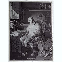
Maschinenfabrik Rüti, vormals Caspar Honegger tex.
Extremely rare woven silk portrait of Jean-Marie Jacquard drawn by Fritz Kaeser after the painting by C. Bonnefond, produced on the famous Honneger mechanical loom in Rüt...
Date: Zürich, Rüti, ca. 1847
