Browse Listings in Map-fair Highlights

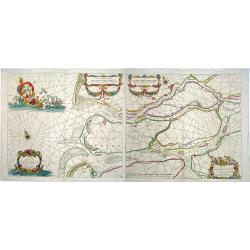
Novus de Leone Belgico eiusq topographia atq. Historica descriptione liber (…). Rerumque in Belgio maxime gestarum, inde ab anno Christi M.D.LIX. Usque ad annum M.D.LXXXVII perpetua narratione continatus.
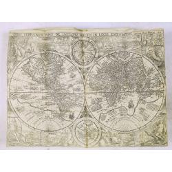
ENLARGED EDITION, with 207 (of 208) engravings of a famous eyewitness account of the Dutch Revolt, with the famous "Leo Belgicus" map, here in its second state...
Date: Cologne, Gerardus Campensis for Frans Hogenberg, 1588
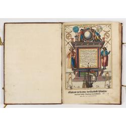
First German text edition of the Spieghel der Zeevaerdt…
First German edition including 47 charts in very fine contemporary colors and bound in a contemp. brown calf binding. The boards are richly blind stamped, with a design ...
Date: Amsterdam, 1593
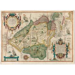
(South America) - Delineatio omnium orarum totius Australis partis Americae, dictae Peruvianae, a R. de la Plata, Brasiliam Pariam, et Castellam auream una cum omnibus…
A particularly lush example of Dutch decorative cartography boasting two intricate strapwork cartouches. Linschoten was one of the prime movers of Dutch and British expan...
Date: Amsterdam, 1593
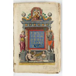
Theatrum Orbis Terrarum.
A Dutch edition of Ortelius' Theatrum Orbis Terrarum "Ghedruckt voor A. Ortelius" (by Corn. Claesz.?), 1598. Illustrated with 92 maps, 91 maps numbered 1-91, in...
- $100000 / ≈ €87277
Date: (Amsterdam, Corn. Claesz.) ?, 1598

Hydrograhica descriptio
This very rare chart is important as the first printed sea chart of the Mediterranean coast of Spain, Gibraltar, also depicting the northern coast of Marocco.Willem Bar...
Date: Amsterdam, W.Blaeu, 1612
!['T Derde deel van 't Licht der zee-vaert, inhoudende de beschryvinghe der zeecusten van de Middelandtsche Zee /, By een vergaedert ende in't licht ghebracht door Willem Janssen. [Blaeu sea atlas].](/uploads/cache/49048-250x250.jpg)
'T Derde deel van 't Licht der zee-vaert, inhoudende de beschryvinghe der zeecusten van de Middelandtsche Zee /, By een vergaedert ende in't licht ghebracht door Willem Janssen. [Blaeu sea atlas].
Extremely rare W. Blaeu's Sea Atlas describing the coasts and islands of the Mediterranean Sea, published in Amsterdam by W. Blaeu" Tot Amsterdam, by Willem Jansz. ...
- $150000 / ≈ €130915
Date: Amsterdam, 1618
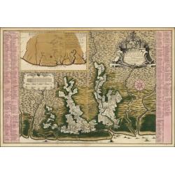
![Hanc Tabulam continens Laetam Pharnambuci.. . [Brazil].](/uploads/cache/16521-250x250.jpg)
Hanc Tabulam continens Laetam Pharnambuci.. . [Brazil].
An extremely rare and decorative map of coast-line of Pernambuco. With one inset: In the upper left corner a map of Brazil, with title in five lines Dutch and five lines ...
Date: Amsterdam, 1630
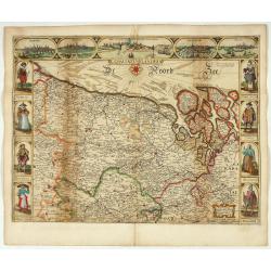
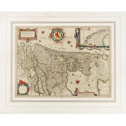
Comitatus Flandria.
Second state of this scarce Carte-a-Figures of Flanders, published by Peter Verbiest in Antwerp decorated with 3 side panels without bottom border (variant of the second ...
Date: Antwerp, 1637
Histoire de la Navigation.
A fine example of Linschoten's classic illustrated travelogue to the East and West Indies, termed by Lach “the most important of the firsthand accounts published indepe...
Date: Amsterdam, Evert Cloppenburgh, 1638

Statt Talbe an der Saal.
Very decorative and rare panoramic town view of Calbe a.d. Saale, Bez Magdeburg.The engraver and publisher of prints, Mrs. Anna Beek of the Hague, enlarged the print and ...
Date: The Hague, ca. 1642

Rerum per octennium in Brasilia Et alibi nuper gestarum, Sub Praefectura Illustrissimi Comitis I. Mauritii, Nassoviae, (...) Historia.
First edition. Commissioned by Johan Maurits van Nassau (governor of Brazil between 1636-1644 and founder of "Mauritsstad" (present-day Recife)) and illustrated...
Date: Amsterdam, J. Blaeu, 1647
Hollandia Comitatus.
1647 BLAEU,W. - The County of Holland by Holland's foremost map publisher from the Golden Age of Dutch cartography.
Date: Amsterdam, 1647
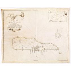
Descripcion de la Isla de Curaçao; Sacada de los Papeles que vinieron a el R.L Consejo de las Indias d. Fran.co Núñez Melián Gouvernador de Venezuela fechos en Caracas en 4° de Diciembre, de 1634 Anos
JUAN DE HERRERA Y ADUILAR - Descripcion de la Isla de Curaçao; Sacada de los Papeles que vinieron a el R.L Consejo de las Indias d. Fran.co Núñez Melián Gouvernador...
Date: Sevillia, c.1635-1652

Pascaarte, van de Zuijderzee, Vliestroom, Vlie, en Amelandergat…
Very rare chart of the Dutch Zuiderzee, here in its rare 5th state (o f6). Showing the coastlines along the Dutch inner sea. Two compass roses indicate north to the left ...
Date: Amsterdam, c. 1660

Hollandiae pars septentrionalis, Vulgo Westvriesland..
Based on the work of B.F.van Berckenrode, this fine map, orientated west to the top of the sheet, includes Kennemerland and Hollands Noorderkwartier and is a reasonably u...
Date: Amsterdam, ca. 1667
L’Atlas de la Mer ou Monde aquaticque.
Original blind-stamped vellum binding; attractive ORIGINAL HAND-COLOR in outline with cartouches, windroses and decoration in full original color; internally some usual m...
Date: Amsterdam, sur le Cay de Teexel, prez du Rams-Koy, au miroir de la Mer, 1670
Paskaerte van het inkoomen van de MAES, Tot aen 't Eylandt Roosenburgh als mede 't Inkoomen van 't Goereesche Gat.. / Pascaert van 't Eylandt Roosenburg door de Oude en Nieuwe Maes....
A very attractive sea chart on two sheets of the mouth of the river Maas. The left sheet shows Dordrecht, Rotterdam and the fortress at Willemstad. Rghthand sheet dep...
Date: Amsterdam, 1680

Amstelodami celeberrimi hollandiae emporii delineatio nova.
Frederik de Wit’s beautiful bird's-eye view of the city. The Amstel river is still open water flowing through the city's heart. Only near the Dam, has it been covered b...
Date: Amsterdam, c.1700

Kaerte en Afbeeldinge vande Geheele Jurisdictie van Stantdarbuyten Gelegen in de Generaliteit onder Marquisaet van Bergen op den Zoom
With a large title cartouche with signature of the maker Adriaan van der Ende, : Kaerte en Afbeeldinge vande Geheele Jurisdictie van Stantdarbuyten Gelegen in de Generali...
Date: Willemstad, 1737
Algemeene kaart van de Colonie of Provintie van Suriname : met de rivieren, districten, ontdekkingen door militaire togten. . .
1740 DE LETH, H. - Large-scale map of Suriname, a record of one of the most important early Jewish communities in the Americas.
Date: Amsterdam, 1740

Chaerte vande Wieringer waert, de welcke inden jaere XVI… (Wieringerwaard)
Rare wall map of the Wieringerwaard polder, as raffled on 12 July 1611. The polder was laid dry in 1610. It border, and the municipality's border, were the Zuiderzee, the...
Date: 1741-1744
Atlas van Zeevaert en Koophandel door de Geheele Weereldt.
Engraved frontispiece, title printed in red and black with engraved vignette, engraved dedication to the Dutch East India Company, 32 double-page engraved charts in very ...
Date: Amsterdam, 1745
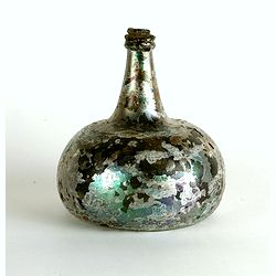
Wine bottle
The Onion-shaped wine bottle is of green glass and is sealed with cork and wax that the cork holds in place. The many years that the bottles spent under the water have l...
Date: Dutch East India Company, Netherlands, ca. 1735-1750

't Hooge Heemraedschap van Delfland met alle de Steden, Dorpen, Ambachten, Litmaten, Polders, (etc.).
The so-called Kruquius map is a wall-map of the Delfland water board district. The map consists of 25 engraved map sheets. Several maps flanked by fine large armorial car...
Date: Delft, 1712-1750

RESTORED CROSSTAFF SEGMENT
RESTORED CROSSTAFF SEGMENT, Dutch, 1757, signed “I*v*K” for Johannes van Keulen, dated “1757” and numbered “23.” The staff is made of ebony, 11/16” (18 mm)...
Date: Amsterdam, 1757

Gesigt van den Vermaakelyken Overtoom ... der stad Amsterdam....
A view of the Overtoom in the eighteenth century. Etching on two joined sheets of paper, after A.Rademaker. By the eighteenth century, numerous country villas had been bu...
Date: Amsterdam, 1760
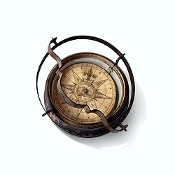
Inverted nautical Compass, called "mouchard" (~ "spy")
Inverted maritime compass called "mouchard" (spy) in wood and brass, signed "A Van Vastenhoud In Amsterdam". This type of compass was found in the cap...
Date: Amsterdam, ca. 1780
![[ LANDSKROON ]. Oranda Fune no zu [= Depiction of a Dutch Ship].](/uploads/cache/28003-250x250.jpg)
[ LANDSKROON ]. Oranda Fune no zu [= Depiction of a Dutch Ship].
A very large and extremely detailed Japanese drawing on rice paper of a Dutch ship at the artificial island Deshima, the VOC's outpost in Nagasaki harbour. In the drawing...
Date: Japan, Kansei 4, 2nd month, 9th day, 30 March? 1792

Straat Riouw onder opzicht van de commissie tot verbetering der Indische Zeekaarten..
Very large and rare so-called Blue Back centered on the strait passing between the Riau Islands. It contains an inset map with enlarged details of Riouw Harbor on Bintang...
Date: Amsterdam 1843

Straat Sunda en Westkust van Java.
Very large and rare chart depicting Java's western seacoast close to the Sunda Strait.Showing part of Sumatra on top and the West Java tip, today hosting the Ujung Kulon ...
Date: Amsterdam (1841)1846
