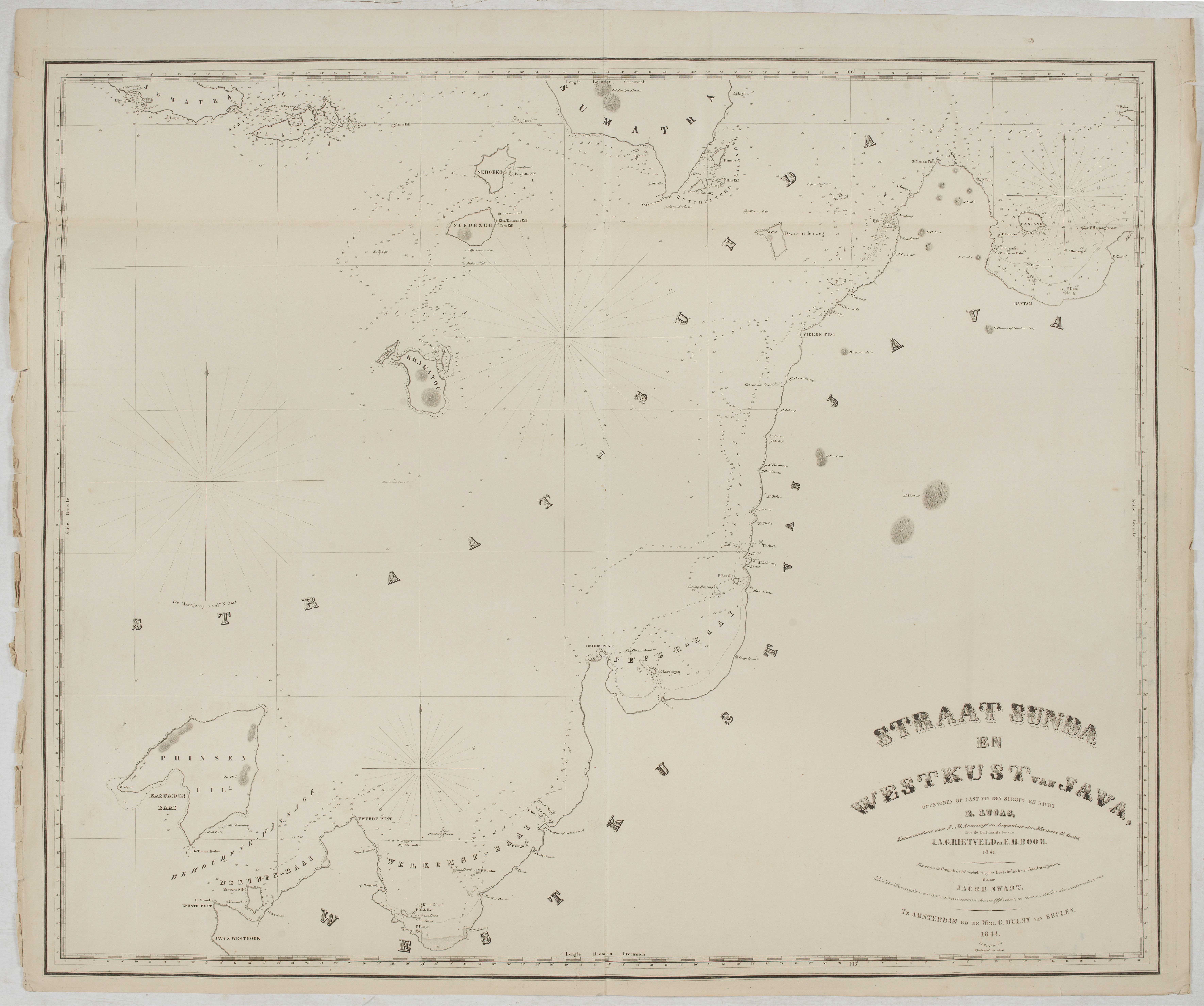
Straat Sunda en Westkust van Java. |
||||||||||||||||||||
|
||||||||||||||||||||
|
|
||||||||||||||||||||
$1500 / ≈ €1318This item is available for immediate sale! Questions before Buying ?
We are happy to answer your questions. |
My Collection +
Add this or any of your favorite items in one place. If you want to save the items permanently, you have to sign in or create an account first.
Watchers:
3
|
|||||||||||||||||||
Description
Very large and rare chart depicting Java's western seacoast close to the Sunda Strait.
Showing part of Sumatra on top and the West Java tip, today hosting the Ujung Kulon National Park, in the lower left corner till Bantam.
The chart is prepared by J.A.G.Rietveld and E.H.Boom in 1841 and updated in 1846 and published in 1846 by Jacob Swart.
Engraved by J.C. Zürcher.
When Gerard Hulst van Keulen died in 1801, his widow ran the firm until her death in 1810, at which time Johannes Hulst van Keulen became the last van Keulen to run the firm.
In 1823, Jacob Swart entered the service of the van Keulen firm, and in 1844, with the death of Johannes Hulst van Keulen, head of the van Keulen Chartmakers was passed to Jacob Swart. When Jacob died in 1866, he was succeeded by his son, Jacob Swart, Jr.
Finally, the possessions of the firm were sold at auction in 1885.
Read more about the van Keulen family of map makers [+]
Read more about the van Keulen family of map makers [+]
FAQ - Guarantee - Shipping
Buying in the BuyNow Gallery
This item is available for immediate purchase when a "Add to Cart" or "Inquire Now" button is shown.
Items are sold in the EU margin scheme
Payments are accepted in Euros or US Dollars.
Authenticity Guarantee
 We provide professional descriptions, condition report (based on 45 years experience in the map business)
Paulus Swaen warrants the authenticity of our items and a certificate of authenticity is provided for each acquired lot.
Condition and Coloring
We indicate the condition of each item and use our unnique HiBCoR grading system in which four key items determine a map's value: Historical Importance, Beauty, Condition/Coloring and Rarity.
Color Key
We offer many maps in their original black and white condition. We do not systematically color-up maps to make them more sellable to the general public or buyer.
Copper engraved or wood block maps are always hand colored. Maps were initially colored for aesthetic reasons and to improve readability. Nowadays, it is becoming a challenge to find maps in their original colors and are therefor more valuable.
We use the following color keys in our catalog:
Original colors; mean that the colors have been applied around the time the map was issued.
Original o/l colors; means the map has only the borders colored at the time of publication.
Colored; If the colors are applied recently or at the end of the 20th century.
Read more about coloring of maps [+]
Shipping fee
A flat shipping fee of $ 30 is added to each shipment by DHL within Europe and North America. This covers : International Priority shipping, Packing and Insurance (up to the invoice amount).
Shipments to Asia are $ 40 and rest of the world $50
We charge only one shipping fee when you have been successful on multiple items or when you want to combine gallery and auction purchases.
Read more about invoicing and shipping
FAQ
Please have a look for more information about buying in the BuyNow gallery
Many answers are likely to find in the general help section.
My Collection+
![]()
With My Collection+ you can collect all your favorite items in one place. It is free, and anyone can create his or her virtual collection.
Unless you are logged in, the item is only saved for this session. You have to be registed and logged-in if you want to save this item permanently to My Collection+.
Read More[+]
Register here, it is free and you do not need a credit card.
Add this item to
My Collection+
or click the following link to see My Collection+.
| Digital Image Download | |
|
Paulus Swaen maintains an archive of most of our high-resolution rare maps, prints, posters and medieval manuscript scans. We make them freely available for download and study. Read more about free image download |
Click the image for a free small image download. |
In accordance with the EU Consumer Rights Directive and habitually reside in the European Union you have the right to cancel the contract for the purchase of a lot, without giving any reason.
The cancellation period will expire 14 calendar days from the day after the date on which you or a third party (other than the carrier and indicated by you) acquires, physical possession of the lot. To exercise the right to cancel you must inform Paulus Swaen Inc, of your decision to cancel this contract by a clear statement (e.g. a letter sent by post, or e-mail.
To meet the cancellation deadline, it is sufficient for you to send your communication concerning your exercise of the right to cancel before the cancellation period has expired.
Recently Viewed

Straat Sunda en Westkust van Java.
Very large and rare chart depicting Java's western seacoast close to the Sunda Strait.Showing part of Sumatra on top and the West Java tip, today hosting the Ujung Kulon ...
Date: Amsterdam (1841)1846
![[Lot of 4 charts] Plan de la Baie et du Port de Camraigne / Plan de la Baie de Niatrang et du Golfe de Binkang / Plan de la Cote de Cochinchine. . . / Plan des Ports de Xuandai, Vung-Lam. . .](/uploads/cache/44795A-250x250.jpg)
[Lot of 4 charts] Plan de la Baie et du Port de Camraigne / Plan de la Baie de Niatrang et du Golfe de Binkang / Plan de la Cote de Cochinchine. . . / Plan des Ports de Xuandai, Vung-Lam. . .
[A set of four French sea charts numbered consecutively]. A set of 4 basic coastal sea charts of parts of southern French Indochina (Vietnam).Chart 295 centers on the reg...
Date: Paris ca 1780

A Map and Chart of Arabia, the Red Sea, & Persian Gulf, drawn from the Chart of the Eastern Ocean, Publish'd in 1740, by Order of ye Count de Maruepas,...
A small but unusual map of the Arabian Peninsular, engraved by G. Child for 'The universal traveller: or, A compleat description of the several nations of the world', by ...
Date: London, Th. Salmon, 1752-1753
![Les Isles Philippines [on sheet with] Islas de los Ladrones ou Isle des Larrons.](/uploads/cache/42023-250x250.jpg)
Les Isles Philippines [on sheet with] Islas de los Ladrones ou Isle des Larrons.
Sanson's important mid-seventeenth-century map of the Philippines and tha Ladrones.It was first engraved by J. Somer for the elder Nicolas Sanson with a privilege for twe...
Date: Amsterdam/Utrecht, 1654
