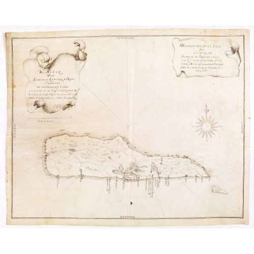
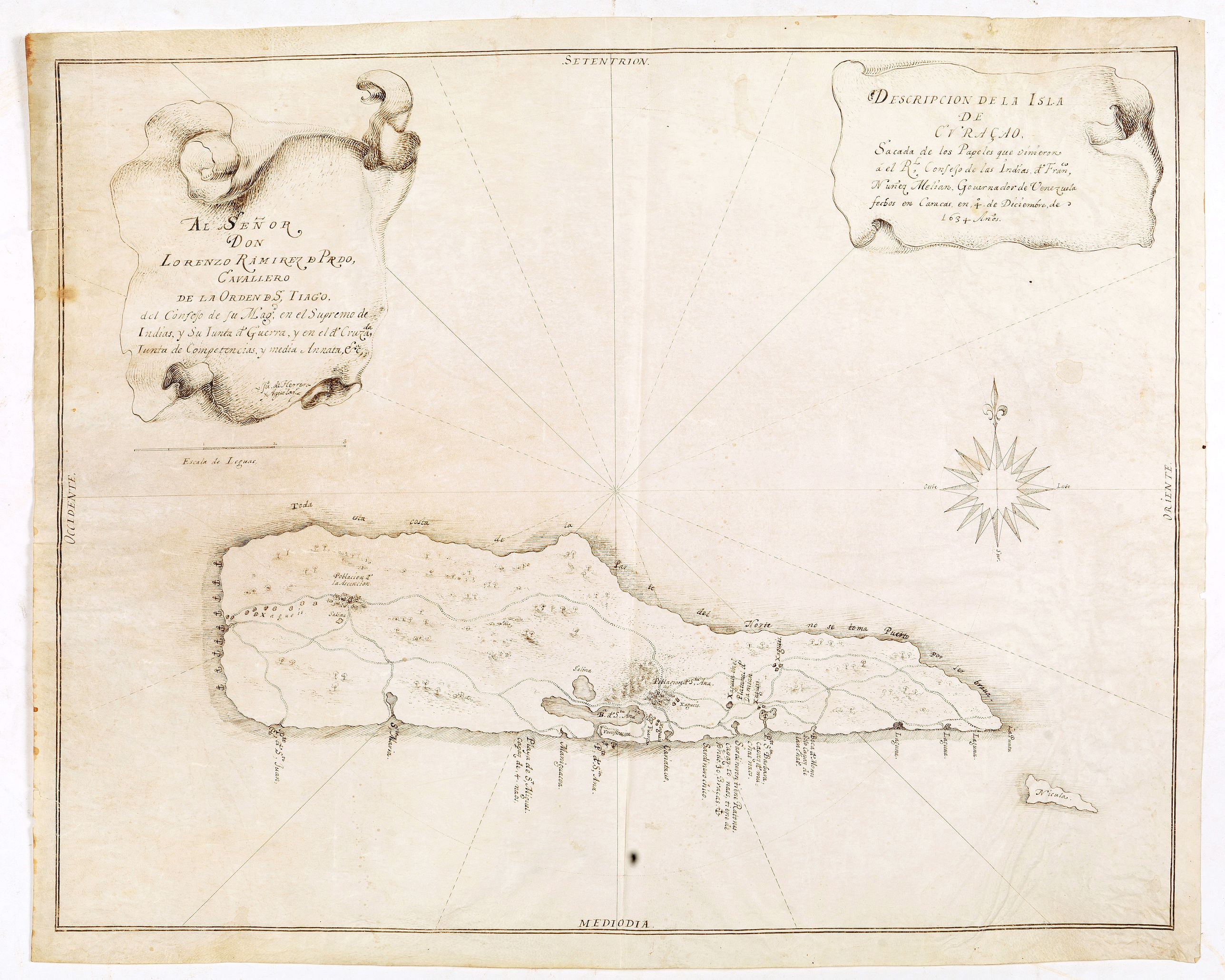
Descripcion de la Isla de Curaçao; Sacada de los Papeles que vinieron a el R.L Consejo de las Indias d. Fran.co Núñez Melián Gouvernador de Venezuela fechos en Caracas en 4° de Diciembre, de 1634 Anos |
||||||||||||||||||||
|
||||||||||||||||||||
|
|
||||||||||||||||||||
$55000 / ≈ €47542
This item is available for immediate sale
55000.00
|
Collection - Save and collect this or any of your favorite items in one place.
If you want to save the items permanently, please sign in or create account first. |
|||||||||||||||||||
Description
JUAN DE HERRERA Y ADUILAR - Descripcion de la Isla de Curaçao; Sacada de los Papeles que vinieron a el R.L Consejo de las Indias d. Fran.co Núñez Melián Gouvernador de Venezuela fechos en Caracas en 4° de Diciembre, de 1634 Anos. (translated in English : Description of the Island of Curaçao; Taken from the papers that came to the R.L Council of the Indies d. Franc Núñez Melián Gouvernador of Venezuela dated in Caracas on December 4, 1634)
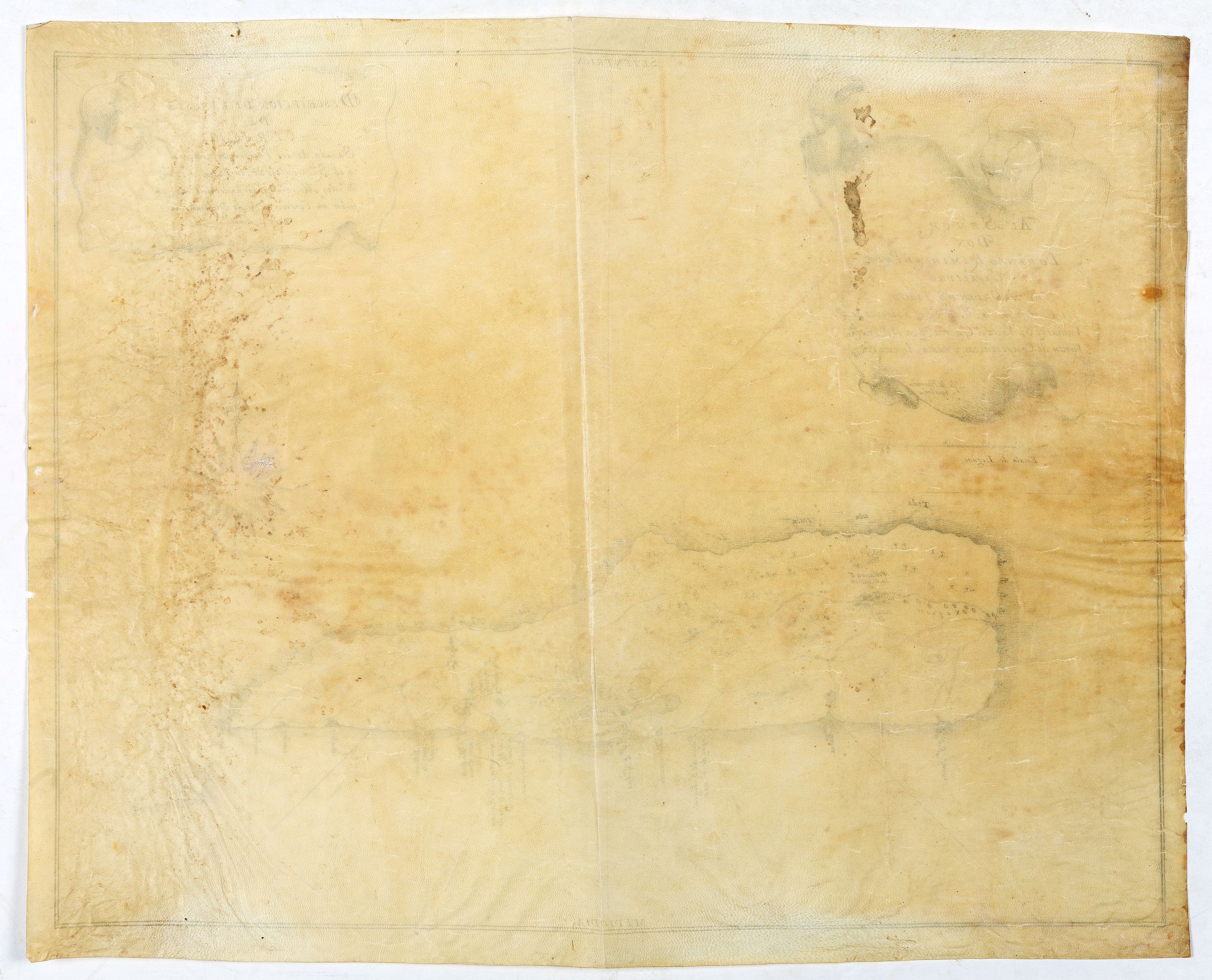
(Sevillia, c.1635-1652) 415x528mm. A very important manuscript chart (Padron) in brown ink on vellum of Curaçao. Very good condition. The chart is very detailed, has many anchor places and names. We see east of Willemstad: “Puerto de Santa Barbara capaz muchos naos”, i.e. the Spanish were aware that this natural harbor could accommodate many ships. Initially, this natural harbor had two inlets; one of them was blocked by a sunken ship in 1639. Afterwards, the harbor could only be entered by passing Caracas Bay.
The map has a dedication to Lorenzo Ramírez de Prado (1583-1658) : "Al Senor Don Lorenzo Ramirez de Pardo, cavallero de la orden D S, Tiago del consejo de su Mag, en el Supremo de Indias, y en d. Cruzada, Iunta de Competencias, y media Annata, Eca."
Francisco Núñez Melián was the Governor of Venezuela from 1630–1637. Between 1643 and 1644, he was the Governor of Yucatán, appointed by Philip IV of Spain. He died while in office on 13 April 1644.
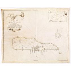
Our map is a close copy of a manuscript map on paper, made by Francisco de Ruesta in 1634, now kept in the National Archives in Sevilia (ES.41091.AGI//MP-VENEZUELA,18).
|
"Descripción de la isla de Curaçao. Sacóla de los papeles que vinieron a el Real Consejo de las Indias, de Francisco Núñez Melián, gouernador de Venezuela, fechos en Caracas en 4 de diciembre de 1634 años".
(See image at https://pares.mcu.es/ParesBusquedas20/catalogo/show/25928 )
Francisco de Ruesta was the official map maker for the "Casa de la Contratación", until 1635 in which year he was succeeded by Herrera y Aguilar. After Herrera y Aguilar took over the office, he clearly used the maps by Francisco de Ruesta, and at least in this case, made a few changes.
|
|
Changes:
|
- The map is now on vellum and 415x528mm. The map by Francisco de Ruesta is on paper and smaller (290x 427mm.)
- The map by Francisco de Ruesta has a similar title but has no dedicational cartouche to Lorenzo Ramírez de Prado.
- Our map is updated with quite a few anchor signs on the East Coast.
|
- The west coast is now more to the center of the map and the island of Klein Curaçao (Little Curaçao, a 1.7-square-kilometre uninhabited island) now shown in full. The island is named by its Aruba Indian name "Nicula".
Juan de Herrera y Aguilar. (1590? - 1652)
He was born into an essential family of illuminators and painters. His father, with the same name, was an illuminator and engraver at Seville at the end of the 16th century, and his elder brother was the famous painter Francisco de Herrera the Elder.
Juan was also an illuminator and cosmographer of the "Casa de Contratación" as mentioned in a document dated 1647.(1) He was named Royal Cosmographer in 1635 (2)
In the inventory of his maps that was made after his death, 27 registers appear, most of them of the Atlantic and American coasts.
This information is found in a little-known document (3), which indicates that the cosmographer Sebastian de Ruesta received from Francisco Ruesta (Chief Pilot of the Casa de Contratación) instruments of his trade, which were found in the house of Doña Juana Pablos, widow of Juan de Herrera y Aguilar: ... and the said instruments are the following 27 padrones (4) [reals].
Herrera y Aguilar was succeeded as cosmographer at the Casa de Contratación by Sebastián de Ruesta (Royal Decree dated June 30, 1652), who took part in the inventory of maps and instruments. Most probably the widower od de Ruesta (Mrs Juana Pablos ) kept with her some part of the inventory.
María Luisa Martín-Merás, cartographer and researcher at the Naval Museum of Madrid, wrote in her reference book ( "Cartografia Maritima Hispana: la imagen de America 1993”) that no preserved map by Herrera y Aguilar is known.
Padron
A "Padron" was a collection of maps that were updated regularly with all the information that pilots were obliged to provide to the “Casa de Contratacion” upon their return from America so that the goal was to have the most updated information as possible of the sailing routes etc.
The Padron is an equivalent of the master charts used by the VOC and called ”ledger”. These charts were completed and corrected when the sailors returned from their trips. They were charts on continuous evolution with the data provided by the navigators.
The history and mapping of Curaçao
The modern history of Curaçao started on 26 July 1499 when the Spanish sighted and claimed the island for Spain by Alonso de Ojeda. Impressed by the size of the Indian inhabitants, the island was named "Isla de los Gigantes". As Curaçao lacked silver and gold resources, the Spaniards did not have much interest in the "Islas inútiles" as they called the Caribbean islands. The first known Spanish map of Curaçao was not drawn before 1634, by Francisco de Ruesta after the Dutch West India Company (WIC) had conquered Curaçao.
On 28 Jul 1634, a Dutch invasion began under Johannes van Walbeeck, and from 21 Aug 1634 until 16 Mar 1792, the island fell under Dutch West India Company administration.
When the Dutch had conquered the island in 1634, they immediately started building a fortification north-east of the island’s main natural harbor St. Anna bay, which nowadays is surrounded by the different quarters of Willemstad.
Hartog (1997, pp. 82-94) records another two locations where fortifications were established for some period of time during the 17th century.
Our chart is an updated version of the Francisco de Ruesta map of 1634 and must have been drawn between 1635 and 1652. Our map is updated with quite a few anchor signs on the east coast, but the area around Willemstad is unchanged. East of St.Anna Bay, we see a sign for a stronghold with the name “Fuerça” (fortress). The construction of the Dutch Fort Amsterdam began in March 1635. The map does not include the Dutch strongholds Blokhuis (1639/40) as well as the Tolcksburg (1639), indicating it could possibly be made before 1639.
The first Dutch map of the island was published by Arent Roggeveen in 1675.
Notes:
1 Let it be known to all who see this letter, that I, Francisco de Herrera y Aguilar, master painter of and imagination, resident of the city of Seville, resident in this Court, grant and acknowledge by this present letter I remain and grant all my power fulfilled and sufficient, as is required and necessary by law, to Juan de Herrera y Aguilar, my brother, resident of the said city of Seville, and cosmographer of the Casa de la Contratassión of said City. CORNEJO, Francisco J. News of Francisco de Herrera el Viejo in Madrid and of the main altarpiece of the College of San Basilio, Seville. Spanish Archive of Art, 2006, vol. 79, no. 316, p. 355-370.
2 PULIDO RUBIO, José. The chief pilot of the House of Trade in Seville: chief pilots, professors of cosmography and cosmographers of the House of Trade in Seville, 1950, p. 100.
3 MANJARRÉS, Ramón de, et al. Bulletin of the Center for Americanist Studies, Year III, February 1915, p. 5 and citation 2, old signature. Trade in Seville, Works of the House of Trade, 1503-1722- 40-6-l2.
4 Royal Register or main map that pilots and cosmographers completed and corrected when they returned from their trips. They were charts on continuous evolution with the data provided by the navigators.
(Sevillia, c.1635-1652) 415x528mm. A very important manuscript chart (Padron) in brown ink on vellum of Curaçao. Very good condition. The chart is very detailed, has many anchor places and names. We see east of Willemstad: “Puerto de Santa Barbara capaz muchos naos”, i.e. the Spanish were aware that this natural harbor could accommodate many ships. Initially, this natural harbor had two inlets; one of them was blocked by a sunken ship in 1639. Afterwards, the harbor could only be entered by passing Caracas Bay. The map has a dedication to Lorenzo Ramírez de Prado (1583-1658) : "Al Senor Don Lorenzo Ramirez de Pardo, cavallero de la orden D S, Tiago del consejo de su Mag, en el Supremo de Indias, y en d. Cruzada, Iunta de Competencias, y media Annata, Eca."
Francisco Núñez Melián was the Governor of Venezuela from 1630–1637. Between 1643 and 1644, he was the Governor of Yucatán, appointed by Philip IV of Spain. He died while in office on 13 April 1644. Our map is a close copy of a manuscript map on paper, made by Francisco de Ruesta in 1634, now kept in the National Archives in Sevilia (ES.41091.AGI//MP-VENEZUELA,18).
| "Descripción de la isla de Curaçao. Sacóla de los papeles que vinieron a el Real Consejo de las Indias, de Francisco Núñez Melián, gouernador de Venezuela, fechos en Caracas en 4 de diciembre de 1634 años". (See image at https://pares.mcu.es/ParesBusquedas20/catalogo/show/25928 )
Francisco de Ruesta was the official map maker for the "Casa de la Contratación", until 1635 in which year he was succeeded by Herrera y Aguilar. After Herrera y Aguilar took over the office, he clearly used the maps by Francisco de Ruesta, and at least in this case, made a few changes.
|
| Changes:
| - The map is now on vellum and 415x528mm. The map by Francisco de Ruesta is on paper and smaller (290x 427mm.) - The map by Francisco de Ruesta has a similar title but has no dedicational cartouche to Lorenzo Ramírez de Prado.
- Our map is updated with quite a few anchor signs on the East Coast.
| - The west coast is now more to the center of the map and the island of Klein Curaçao (Little Curaçao, a 1.7-square-kilometre uninhabited island) now shown in full. The island is named by its Aruba Indian name "Nicula".
Juan de Herrera y Aguilar. (1590? - 1652)
He was born into an essential family of illuminators and painters. His father, with the same name, was an illuminator and engraver at Seville at the end of the 16th century, and his elder brother was the famous painter Francisco de Herrera the Elder.
Juan was also an illuminator and cosmographer of the "Casa de Contratación" as mentioned in a document dated 1647.(1) He was named Royal Cosmographer in 1635 (2)
In the inventory of his maps that was made after his death, 27 registers appear, most of them of the Atlantic and American coasts.
This information is found in a little-known document (3), which indicates that the cosmographer Sebastian de Ruesta received from Francisco Ruesta (Chief Pilot of the Casa de Contratación) instruments of his trade, which were found in the house of Doña Juana Pablos, widow of Juan de Herrera y Aguilar: ... and the said instruments are the following 27 padrones (4) [reals]. Herrera y Aguilar was succeeded as cosmographer at the Casa de Contratación by Sebastián de Ruesta (Royal Decree dated June 30, 1652), who took part in the inventory of maps and instruments. Most probably the widower od de Ruesta (Mrs Juana Pablos ) kept with her some part of the inventory. María Luisa Martín-Merás, cartographer and researcher at the Naval Museum of Madrid, wrote in her reference book ( "Cartografia Maritima Hispana: la imagen de America 1993”) that no preserved map by Herrera y Aguilar is known.
Padron
A "Padron" was a collection of maps that were updated regularly with all the information that pilots were obliged to provide to the “Casa de Contratacion” upon their return from America so that the goal was to have the most updated information as possible of the sailing routes etc.
The Padron is an equivalent of the master charts used by the VOC and called ”ledger”. These charts were completed and corrected when the sailors returned from their trips. They were charts on continuous evolution with the data provided by the navigators.
The history and mapping of Curaçao
The modern history of Curaçao started on 26 July 1499 when the Spanish sighted and claimed the island for Spain by Alonso de Ojeda. Impressed by the size of the Indian inhabitants, the island was named "Isla de los Gigantes". As Curaçao lacked silver and gold resources, the Spaniards did not have much interest in the "Islas inútiles" as they called the Caribbean islands. The first known Spanish map of Curaçao was not drawn before 1634, by Francisco de Ruesta after the Dutch West India Company (WIC) had conquered Curaçao. On 28 Jul 1634, a Dutch invasion began under Johannes van Walbeeck, and from 21 Aug 1634 until 16 Mar 1792, the island fell under Dutch West India Company administration. When the Dutch had conquered the island in 1634, they immediately started building a fortification north-east of the island’s main natural harbor St. Anna bay, which nowadays is surrounded by the different quarters of Willemstad.
Hartog (1997, pp. 82-94) records another two locations where fortifications were established for some period of time during the 17th century.
Our chart is an updated version of the Francisco de Ruesta map of 1634 and must have been drawn between 1635 and 1652. Our map is updated with quite a few anchor signs on the east coast, but the area around Willemstad is unchanged. East of St.Anna Bay, we see a sign for a stronghold with the name “Fuerça” (fortress). The construction of the Dutch Fort Amsterdam began in March 1635. The map does not include the Dutch strongholds Blokhuis (1639/40) as well as the Tolcksburg (1639), indicating it could possibly be made before 1639. The first Dutch map of the island was published by Arent Roggeveen in 1675.
Notes:
1 Let it be known to all who see this letter, that I, Francisco de Herrera y Aguilar, master painter of and imagination, resident of the city of Seville, resident in this Court, grant and acknowledge by this present letter I remain and grant all my power fulfilled and sufficient, as is required and necessary by law, to Juan de Herrera y Aguilar, my brother, resident of the said city of Seville, and cosmographer of the Casa de la Contratassión of said City. CORNEJO, Francisco J. News of Francisco de Herrera el Viejo in Madrid and of the main altarpiece of the College of San Basilio, Seville. Spanish Archive of Art, 2006, vol. 79, no. 316, p. 355-370.
2 PULIDO RUBIO, José. The chief pilot of the House of Trade in Seville: chief pilots, professors of cosmography and cosmographers of the House of Trade in Seville, 1950, p. 100.
3 MANJARRÉS, Ramón de, et al. Bulletin of the Center for Americanist Studies, Year III, February 1915, p. 5 and citation 2, old signature. Trade in Seville, Works of the House of Trade, 1503-1722- 40-6-l2. 4 Royal Register or main map that pilots and cosmographers completed and corrected when they returned from their trips. They were charts on continuous evolution with the data provided by the navigators.
FAQ - Guarantee - Shipping
Buying in the BuyNow Gallery
This item is available for immediate purchase when a "Add to Cart" or "Inquire Now" button is shown.
Items are sold in the EU margin scheme
Payments are accepted in Euros or US Dollars.
Authenticity Guarantee
 We provide professional descriptions, condition report (based on 45 years experience in the map business)
Paulus Swaen warrants the authenticity of our items and a certificate of authenticity is provided for each acquired lot.
Condition and Coloring
We indicate the condition of each item and use our unnique HiBCoR grading system in which four key items determine a map's value: Historical Importance, Beauty, Condition/Coloring and Rarity.
Color Key
We offer many maps in their original black and white condition. We do not systematically color-up maps to make them more sellable to the general public or buyer.
Copper engraved or wood block maps are always hand colored. Maps were initially colored for aesthetic reasons and to improve readability. Nowadays, it is becoming a challenge to find maps in their original colors and are therefor more valuable.
We use the following color keys in our catalog:
Original colors; mean that the colors have been applied around the time the map was issued.
Original o/l colors; means the map has only the borders colored at the time of publication.
Colored; If the colors are applied recently or at the end of the 20th century.
Read more about coloring of maps [+]
Shipping fee
A flat shipping fee of $ 30 is added to each shipment by DHL within Europe and North America. This covers : International Priority shipping, Packing and Insurance (up to the invoice amount).
Shipments to Asia are $ 40 and rest of the world $50
We charge only one shipping fee when you have been successful on multiple items or when you want to combine gallery and auction purchases.
Read more about invoicing and shipping
FAQ
Please have a look for more information about buying in the BuyNow gallery
Many answers are likely to find in the general help section.
Collection
![]()
With Collection you can collect all your favorite items in one place. It is free, and anyone can create his or her Virtual map collection.
Unless you are logged in, the item is only saved for this session. You have to be registed and logged-in if you want to save this item permanently to your Virtual Collection.
Read More[+]
Register here, it is free and you do not need a credit card.
Add this item to
Virtual Collection
or click the following link to see my Collection.
| Digital Image Download | |
|
Paulus Swaen maintains an archive of most of our high-resolution rare maps, prints, posters and medieval manuscript scans. We make them freely available for download and study. Read more about free image download |
Click the image for a free small image download. |
In accordance with the EU Consumer Rights Directive and habitually reside in the European Union you have the right to cancel the contract for the purchase of a lot, without giving any reason.
The cancellation period will expire 14 calendar days from the day after the date on which you or a third party (other than the carrier and indicated by you) acquires, physical possession of the lot. To exercise the right to cancel you must inform Paulus Swaen Inc, of your decision to cancel this contract by a clear statement (e.g. a letter sent by post, or e-mail (amsterdam@swaen.com).
To meet the cancellation deadline, it is sufficient for you to send your communication concerning your exercise of the right to cancel before the cancellation period has expired.
