Browse Listings in Recent acquisitions
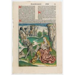
Quita etas Mundi Folium XCIIII
The Latin text page is illustrated with a depictions of Kings, Noble men and women and scientists, like Strabo, a historian, geographer and philosopher. Mother Mary and Z...
Date: Nuremberg, 12 July 1493
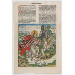
Prima Etas Mundi. VI
A very fine presentation of Eve, being created by God from Adam’s side.Page from the richest illustrated Incunable, the famous: Nuremberg Chronicle, published the year th...
Date: Nuremberg, 12 July 1493
![[Sea monsters] De regni Settentrionali Monstri marini & terrestri…](/uploads/cache/49169-250x250.jpg)
[Sea monsters] De regni Settentrionali Monstri marini & terrestri…
Münster's plate of monsters of both land and sea, taken from an Italian text edition of Münster's Cosmographia, which is a short and complete summary of Renaissance knowl...
Date: Basel, 1558
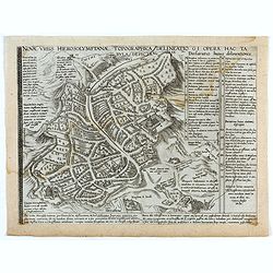
Novae Urbis Hierosolymitanae topographica delineatio . . .
A very rare plan of modern Jerusalem oriented to the east, according to a note on the map the map was drawn after a map by Peter Laicstain. A lettered key to the right.Up...
Date: Antwerp, 1571
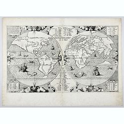
Benedict. Arias Montanus Sacrae Geographiae Tabulam Ex Antiq
THE EXTREMELY RARE FIRST STATE landmark world map, famed for its depiction of the Australian landmass.One of the earliest printed maps to depict the “terra incognita” of...
Date: Anvers 1571 /1572
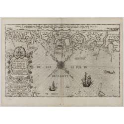
De Zee-Kuste vant Landt te Noort-oosten sorterende onder Norweghen ende eendeels onder Sweden alsoe tlandt aldaer in zijn gedaente is, van Distelberch tot Waersberghe.
A rare Latin text edition of this early and detailed chart of the coast of Norway of this landmark contribution to the science of navigation. Decorated by a large title c...
Date: Leiden, Plantijn, 1585
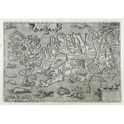
Islandia.
1603 ORTELIUS, A. - Perhaps the most famous map of Iceland. On the south side of the island, a collection of all possible sea monsters is depicted. Polar bears on ice flo...
Date: Antwerp, 1603
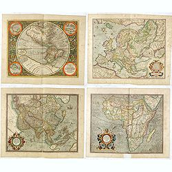
Set of four continents.
Fine set of 4 continents prepared by Gerard Mercator. The general map of Europe, as well as Americae Pars, Greenland, Iceland, a Polar landmass, along with the mythical i...
Date: Amsterdam, 1628

Nouvelle et exacte Carte du Duche de Brabant. . .
A very rare example of a map of the Duchy of Brabant. Title cartouche in the lower left-hand corner. A very rare issue of this map of Brabant. Cornelis Danckerts II. copi...
Date: Amsterdam, 1635
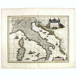
Nova Italiae delineatio.
Originally engraved for Jodocus Hondius II, at his death in August 1629 this map was, among other copper plates,purchased by Willem Blaeu who trimmed the figured borders,...
Date: Amsterdam, 1638
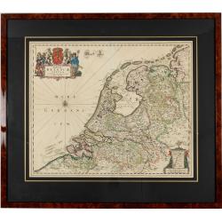
Foederatae Belgicae Tabulae.
Fine, detailed map of the area of the modern Netherlands, less the southern part of Limburg, of which the small area around the town of Maastricht is shown in the inset b...
Date: Amsterdam, 1680
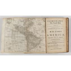
Cosmography in Four Books. Containing the Chorography and History of the Whole World: and all the Principal Kingdoms, Provinces, Seas,
Extensive description of the world by Peter Heylyn. Here the 6th edition corrected and enlarged by the author. Including 4 maps.The map of America showing California as a...
Date: London, 1682
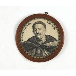
Ioannes III. Rex. Poloniae (Portrait of Johann III. Sobieski)
On verso a text in brown ink "1674 Giovanni Sobieski Gran Maresciallo della Polonia, che poscia lo fece suo Re, perchè a Cokrim vinse li Turchi, e la liberò dai trib...
Date: Ulm, ca. 1690

Moris Beneficio Comendatus Tabaci usus. Der durch die Mode beliebt gemachteTaback
Copper-plate engraving showing a group of fashionably dressed men and women smoking long-stemmed pipes around a table in front of a garden hedge. "Paulus Decker inv....
Date: Augsburg, 1700
![[Concert at time of Handel] Dulcissimum Melos Bona Fama.](/uploads/cache/47201-250x250.jpg)
[Concert at time of Handel] Dulcissimum Melos Bona Fama.
Copper-plate engraving of the rehearsal of a chamber cantata by Johann Christoph Steudner, after Paul Decker the elder, in the Handel-Haus, Halle. (Musikgeschichte in Bil...
Date: Augsburg, 1700
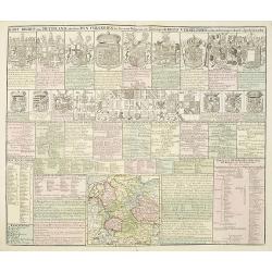
Kort Begryp van Duytsland, de drie Ryx Collegien in hunne Wapens en Zittingen. Kreits Verelingen en Aantekenigen door C. Specht't Utrectht.
Second state of this decorative table of family escutcheons, crests and coats of arms, for various German and Dutch princes and nobles of the 16th, 17th and 18th Centurie...
Date: Amsterdam, 1720
![(Chatelain "Atlas Historique" in 7 volumes.]](/uploads/cache/47053X-250x250.jpg)
(Chatelain "Atlas Historique" in 7 volumes.]
Henri Abraham Chatelain, whose Atlas Historique was one of the most expansive encyclopedias of the age. First published in 1705, Chatelain's Atlas Historique was part o...
Date: Amsterdam: Chez Zacharie Châtelain, 1732 - 1739
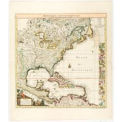
Amerique Septentrionale suivant la carte de Pople faite à Londres en 20 feuilles.
The key sheet to Henry Le Rouge/Popple wall map of the British Colonies in North America. Appears in the author's Atlas Général [1741-62].Key map of the French edition ...
Date: Paris, Le Rouge, 1742
![[Manuscript chart on vellum of the Java Sea]](/uploads/cache/33613-250x250.jpg)
[Manuscript chart on vellum of the Java Sea]
One of the few manuscript charts on vellum in private hands, signed by Isaac de Graaf. ORIGINAL MANUSCRIPT MAP IN RED, GREEN AND BLACK INK showing the Java Sea centered o...
Date: Amsterdam, 1743
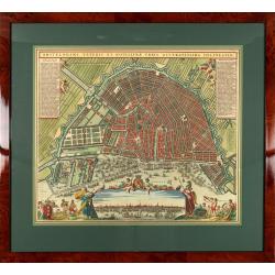
Amstelodami veteris et novissimae urbis accuratissima deline
A decorative plan of the town with legends on the left and right mentioning the most important buildings and streets. At bottom center a view of the town from 't IJ. From...
Date: Amsterdam, 1745-1754

Carta Topografica dell' Isola Del Maritaggio di Monsieur le Boble per la prima volta. Tradotta dal francese in italiano.
Second Italian printing of Eustache Le Noble’s "Carte de l’isle de marriage." The book’s text offers instructions on how to reach this matrimonial island and de...
Date: Cosmopoli, 1766

Nieuwe Kaart van de Grootbrittannische Volkplantingen in Noord America waar in Tevens de Fransche Bezittingen en de Landen tuschen die Beide Volken. . .
A map of the east-coast of America from New Foundland till Florida, divided in French and British properties. Reduced size Dutch edition of Mitchell's map of North Americ...
Date: Amsterdam, 1769
![[HAWAII] - Plan de la baye de Karakakooa.](/uploads/cache/48173-250x250.jpg)
[HAWAII] - Plan de la baye de Karakakooa.
Beautiful map showing the islands forming the Hawaiian archipelago, drawn up during Cook's third voyage: Oneeheow or Ni'ihau, Atooi or Kauai, Woahoo or O'ahu, Morotoi or ...
Date: Paris, 1774
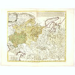
Russian Empire in Europe from the Dr. D'Anville of the Royal Academy. . .
Rare map of Russia, prepared by John Bayly (active 1755-1794) after D'Anville. In the lower-left corner parts of the Caspian and Black Sea. In the upper right corner Nova...
Date: London, ca. 1782

Cherries.
Color aquatint and stipple engraved plate of fruits by George Brookshaw (1751-1823) from his "Pomona Britannica; or, a Collection of the most esteemed fruits at pres...
Date: London, Bensley and son, 1817

Cary's New Terrestrial Globe Exhibiting The Tracks and Discoveries made by Captain Cook; Als...
An early Regency 21-inch terrestrial globe CARY, John and William. - Cary's New Terrestrial Globe Exhibiting The Tracks and Discoveries made by Captain Cook; Also those o...
Date: London, 1815/1818
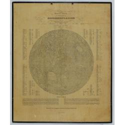
General-Karte der sichtbaren Seite der Mond-oberflaeche zugleich als Übersichts-Blatt zur grössern Mondkarte von Wilh. Beer und Joh: Heinr. Mädler.
An early representation of the viewable surface of the moon by Johann Heinrich Mädler (1794-1874) and Wilhelm Beer (1797-1850).Ignoring the occasional pre-telescopic app...
Date: Berlin, 1837

Korte geographische oefeningen voor het eerste onderwijs in de kennis der geheele aarde
Ilustrated with World Map, map of Europe, the Netherlands, Asia, Africa, North America, South America and Australia.Provenance : J.de Veth, October 1845.
Date: Zaltbommel, 1843
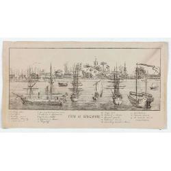
View of Singapore
Very rare view of Singapore from the Singapore River Basin. With a numbered key (1-19) underneath the illustration. In the center Government Hill with Governer's House (1...
Date: ca. 1850
Volume III of the monumental atlas, ‘L’Orbe Cattolico ossia Atlante Geografico Storico Ecclesiastico’.
PETRI Girolamo's extremely rare Atlas volume III of the monumental atlas, ‘L’Orbe Cattolico ossia Atlante Geografico Storico Ecclesiastico’, respectively depicting eccl...
Date: Rome, 1858
![[Lot of 9 maps] Plan général de Sébastopol avec indication des travaux du siege et de la defense au 28 mars - 9 avril 1855. Feuille 10. xiii](/uploads/cache/33907-250x250.jpg)
[Lot of 9 maps] Plan général de Sébastopol avec indication des travaux du siege et de la defense au 28 mars - 9 avril 1855. Feuille 10. xiii
A group of nine (of 14) very rare panoramic town-plans of the siege of Sebastopol or maps of the Crimea. In lower margin : "Gravé au Dépôt topographique de la Guerre...
Date: St. Petersburg, N. Thieblin, 1863
Atlas usuel de Géographie Moderne…
Complete with title page, contents page, and all 32 double-page maps of European and regional maps of the world, including Oceania, the Americas, Asia, Africa, etc. All i...
Date: Paris, c. 1865
Selling price: ????
Please login to see price!
Sold in 2024
Atlas de Géographie Physique, Politique, Ancienne et Moderne contenant les cartes générales et particulières toutes les parties du Monde.
Complete with title page, contents page, and all 35 double-page maps of European and regional maps of the world, including Oceania, the Americas, Asia, Africa, etc. All i...
Date: Paris, 1875
Selling price: ????
Please login to see price!
Sold in 2024

Mapa Polski i Krajów Osciennych - Wydanie trzecie. Opracowal Stanislaw Max. Wydani M. Arcta.
‘The Birth of Modern Poland on a map’ - an excellent wall map of Poland and surrounding regions, published in Warsaw near the end of World War I, when Poland’s fate was u...
Date: Warsaw, [H. Sklodowski], 1918
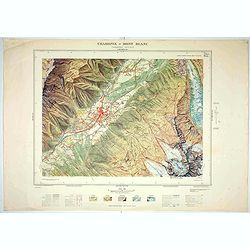
Chamonix - Mont Blanc - Chamonix N°5 Sud.
Magnificent 1:10,000 scale color printed map of Chamonix - Mont Blanc (Chamonix N°5 Sud) based on stereotopographic ground and aerial surveys carried out in the field in ...
Date: Paris, 1953
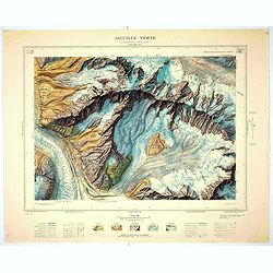
Aiguille verte - Chamonix N°6 Sud
Magnificent 1:10,000 scale color printed map of l'Aiguille verte (Chamonix N°6 Sud) based on stereotopographic ground and aerial surveys carried out in the field in 1950 ...
Date: Paris, 1953
![[Title in Russian; translated to : Believe in the power of a nuclear trucheon - It's up to you to celebrate a wake. ]](/uploads/cache/41508-250x250.jpg)
[Title in Russian; translated to : Believe in the power of a nuclear trucheon - It's up to you to celebrate a wake. ]
Propaganda mini poster published in Russia during The Cold War (1979–1985). The time refers to the phase of a deterioration in relations between the Soviet Union and the ...
Date: Russia, 1982
![[A collection of 100 Soviet propaganda poster published in the 1980's]](/uploads/cache/47076-250x250.jpg)
[A collection of 100 Soviet propaganda poster published in the 1980's]
A collection of 100 Soviet propaganda posters published during the early years of the Perestroika & Glasnost period. Most posters are made by Plakat (All-Union Poster...
Date: Moscow, ca. 1980-1989
