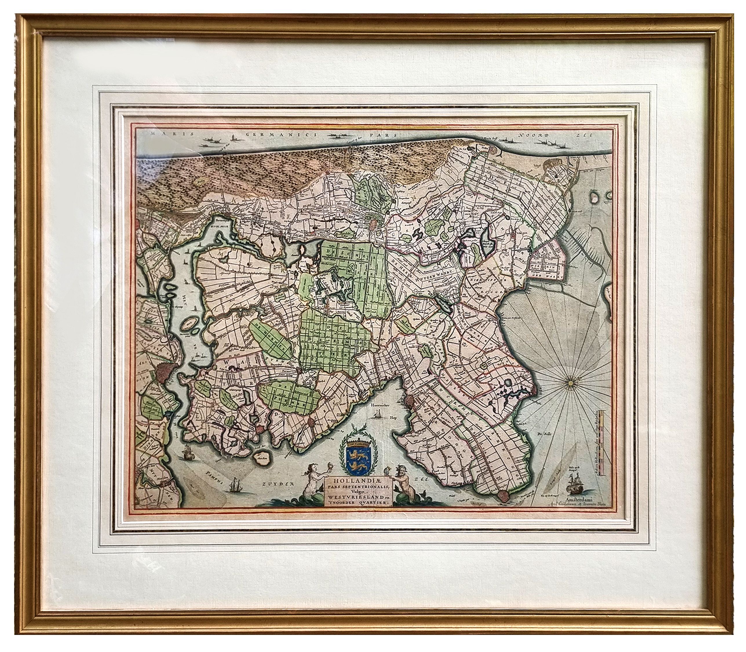
Hollandiae pars septentrionalis, Vulgo Westvriesland.. |
||||||||||||||||||||
|
||||||||||||||||||||
|
|
||||||||||||||||||||
$2500 / ≈ €2182This item is available for immediate sale! Questions before Buying ?
We are happy to answer your questions.
2500.00
|
My Collection + - Save and collect this or any of your favorite items in one place.
If you want to save the items permanently, please sign in or create account first. |
|||||||||||||||||||
Description
Based on the work of B.F.van Berckenrode, this fine map, orientated west to the top of the sheet, includes Kennemerland and Hollands Noorderkwartier and is a reasonably up-to-date depiction of the reclamation of this part of the country in the period after 1544 when Charles V created the single water control authority of the Hoogheemraedschap van de Uitwaterende Sluizen van Kennemerland en Westfriesland.
The polders, principally the work of J.A. Leeghwater, include Wogmeer (1607-08), Beemster (1607-12), Purmer (1617-22), Wormer (1624-26), Heerhugowaard (1625-31), Schermer (1631-35), whilst other lakes are indicated as drained but without drainage canals engraved.
Lavishly colored and heightened with gold by the master colorist Dirk Jansz. van Santen..
The coloring is attributed to the 17th-century master colorist DIRK JANSZ VAN SANTEN (1637-1708). The map is lavishly colored, using gold for the cartouches and further embellishment and major cities. The scale of longitude and latitude are triple: the variation in tone and color from red and blue-green alternating with gold yields a lively effect. The figures around the cartouches are painted in a somewhat impressionistic way that is characteristic of Van Santen, with many dark shadow areas to highlight the colors.
The celebrated Dutch master colorist Dirk Jansz. Van Santen (1637/38-1708), whose manner is signified by rich and exotic color combinations, added elements such as flowers to clothing and marbling to masonry (found here).
Goedings : "Van Santen applied transparent and opaque colors at the same time in both mixed and pure tints. He often painted the whole surface of the map or illustration, transforming the graphic light and dark contrasts into color.
He applied his characteristic shiny varnish, which had the effect of brightening the color, frequently making use of the same color progression."
Atlases and books colored by van Santen are found in the libraries of the most prominent collectors of the golden age of Dutch cartography ". Bibles and atlases, bound in deluxe bindings by Albert Magnus (1642-1689) and decorated by van Santen were considered gifts worthy of princes. Travelers and poets wrote about this work" (Goedings).
More about Dirk Jansz van Santen
Parts of the item are heightened in gold. Read more about maps heightened in gold.
FAQ - Guarantee - Shipping
Buying in the BuyNow Gallery
This item is available for immediate purchase when a "Add to Cart" or "Inquire Now" button is shown.
Items are sold in the EU margin scheme
Payments are accepted in Euros or US Dollars.
Authenticity Guarantee
 We provide professional descriptions, condition report (based on 45 years experience in the map business)
Paulus Swaen warrants the authenticity of our items and a certificate of authenticity is provided for each acquired lot.
Condition and Coloring
We indicate the condition of each item and use our unnique HiBCoR grading system in which four key items determine a map's value: Historical Importance, Beauty, Condition/Coloring and Rarity.
Color Key
We offer many maps in their original black and white condition. We do not systematically color-up maps to make them more sellable to the general public or buyer.
Copper engraved or wood block maps are always hand colored. Maps were initially colored for aesthetic reasons and to improve readability. Nowadays, it is becoming a challenge to find maps in their original colors and are therefor more valuable.
We use the following color keys in our catalog:
Original colors; mean that the colors have been applied around the time the map was issued.
Original o/l colors; means the map has only the borders colored at the time of publication.
Colored; If the colors are applied recently or at the end of the 20th century.
Read more about coloring of maps [+]
Shipping fee
A flat shipping fee of $ 30 is added to each shipment by DHL within Europe and North America. This covers : International Priority shipping, Packing and Insurance (up to the invoice amount).
Shipments to Asia are $ 40 and rest of the world $50
We charge only one shipping fee when you have been successful on multiple items or when you want to combine gallery and auction purchases.
Read more about invoicing and shipping
FAQ
Please have a look for more information about buying in the BuyNow gallery
Many answers are likely to find in the general help section.
My Collection+
![]()
With My Collection+ you can collect all your favorite items in one place. It is free, and anyone can create his or her virtual collection.
Unless you are logged in, the item is only saved for this session. You have to be registed and logged-in if you want to save this item permanently to My Collection+.
Read More[+]
Register here, it is free and you do not need a credit card.
Add this item to
My Collection+
or click the following link to see My Collection+.
| Digital Image Download | |
|
Paulus Swaen maintains an archive of most of our high-resolution rare maps, prints, posters and medieval manuscript scans. We make them freely available for download and study. Read more about free image download |
Click the image for a free small image download. |
In accordance with the EU Consumer Rights Directive and habitually reside in the European Union you have the right to cancel the contract for the purchase of a lot, without giving any reason.
The cancellation period will expire 14 calendar days from the day after the date on which you or a third party (other than the carrier and indicated by you) acquires, physical possession of the lot. To exercise the right to cancel you must inform Paulus Swaen Inc, of your decision to cancel this contract by a clear statement (e.g. a letter sent by post, or e-mail.
To meet the cancellation deadline, it is sufficient for you to send your communication concerning your exercise of the right to cancel before the cancellation period has expired.
