Popular Listings

Carte du Kouy-Tchéou.
Detailed map of Guizhou Province prepared by Mgr. Faurie and other sources supplied by missionaries. Published in "Les Missions Catholique". Engraved by P. Méa....
Date: Lyon, c.1874

Russiae vulgo Moscovia dictae, Partes Septentrionalis et orientalis.
In the north the Murmansk Sea. Including the western coast of Nova Zembla. Title cartouche and two cartouches, the bottom right one showing two hunters, bears, stags etc....
Date: Amsterdam, 1647

Leaf on vellum from a antiphonary.
A leaf from a Medieval Antiphonal or Choir Missal for Spanish use, in Latin on extremely heavy vellum. Justification: 360x246mm. Text is in Spanish rounded gothic hand (R...
Date: Sevilla, ca.1520
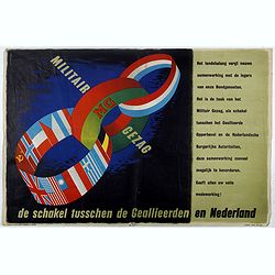
MG Militair Gezag. De schakel tusschen de Geallieerden en Nederland.
Poster on the Allied military cooperation published by the Dutch Military Government. The poster has three colorful linked rings against a dark black and blue background....
Date: London, James Haworth & Brother LTD, 1944 - 1945

New York Ferry Boat. (Bac à vapeur de New York).
A very decorative print showing the New York Ferry Boat "Fulton," published by Currier & Ives. The Ferry boat "Fulton" sails to the right. A singl...
Date: New York, ca. 1875

Pascaerte van Brazil en Nieu Nederlandt van Cuorvo en Flores.
A rare chart of the Atlantic Ocean from the first edition of Hendrick Doncker's Zee-Atlas, of which no surviving example is known.Although the idea of its unusual coverag...
Date: Amsterdam, 1658
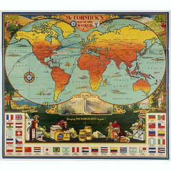
McCormick's Map of the World.
Colorful promotional map of the 20th century spice trade.What better way to showcase the global composition of a multi-national company than with a world map? This lovely...
Date: United-States, 1931
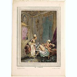
Le Curieux.
A risqué but delightful French engraving produced in the late eighteenth century. It is simply titled The Curious, and shows a young lady lying on her side on a divan, wi...
Date: Paris, ca. 1790

Vue de L'Hotel de Batavie. . .
A so-called optical print of Fatahillah Square in Jakarta, Indonesia, prepared for use in a light-box or an amusing light-show. This richly hand colored print is much per...
Date: Augsburg, 1750

Hydrograhica descriptio
This very rare chart is important as the first printed sea chart of the Mediterranean coast of Spain, Gibraltar, also depicting the northern coast of Marocco.Willem Bar...
Date: Amsterdam, W.Blaeu, 1612

Virginie, Grande Region l'Amerique Septentrionale...
Pierre van der Aa used the old copper plate of Meurs and re-did the engraving, changed the large pictorial cartouche, a new scale of German and French leagues is provided...
Date: Amsterdam, 1729
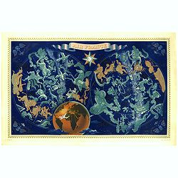
AIR France - Réseau Aérien Mondial.
Original pictorial lithograph advertising planisphere poster from AIR France. The poster has a black background. In the lower right below the border '016/P/AF Printed in ...
Date: Imprimerie Perceval, Paris, ca. 1950

Belgii sive Germaniae Inferioris accuratissima tabula.
Very rare and very decorative map with in the right and left borders costumed figures and town plans alternately. In top and bottom border town plans and views.Separate p...
Date: Amsterdam, 1631
![[India and China]](/uploads/cache/33875-250x250.jpg)
[India and China]
Wood block printed map and one of earliest printed representation of India and China prepared Martin Waldseemüller. Based on the slightly larger map from 1513 published i...
Date: Vienna, 1525 -1541
![De Texel Stroom met de gaten vant Marsdiep. [with] Caarte van De Mase ende het Goereesche Gat.](/uploads/cache/12097-250x250.jpg)
De Texel Stroom met de gaten vant Marsdiep. [with] Caarte van De Mase ende het Goereesche Gat.
Two decorative charts on one sheet, one depicting Texel and the entrance of the Zuider Zee with an inset showing the north coast of West-Friesland, the other depicting th...
Date: Amsterdam, 1660

(Sea-chart of Catalunia, Languedoc, Provence, Cote d'Azur, Riviera, Corsica with Marseille, Cannes, Nice, Monaco.)
This very rare chart is important as the first printed sea chart of France's Mediterranean coast, also depicting Catalunya's northern coast, the Italian Cote d'Azur till ...
Date: Amsterdam, 1607

Vue de cavite dans la Baie de Manille.
Two boats and passengers with Cavite Philippines in the background as if was seen from Manila Bay in January 1787. After a design of Gaspard Duchè de Vancy and engraved b...
Date: Paris, 1798

View of the harbour of Taloo, in the island of Eimeo.
John Webber View of the Harbour of Taloo on Moorea (Society Islands), from "Views in the South Seas" being a very important and early views depicting scenes enc...
Date: London, Boydell and Co., 1808
![Le Sacre Hagard [Haggard-falcon]](/uploads/cache/44315-250x250.jpg)
Le Sacre Hagard [Haggard-falcon]
A beautiful elephant folio sized colored lithograph of a Hagard Falcon, taken from the famous book on Falconry Traite de Fauconnerie by Schlegel and A.H. Verster van Wulv...
Date: Leiden, 1844-1853
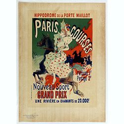
Hippodrome de la porte Maillot. Paris Courses.
Chromo lithographed mini poster, " Hippodrome de la porte Maillot. Paris Courses. Pelouse 1 f. pesage 2 f. Nouveau sport. Grand prix : une rivière en diamants de 20,...
Date: Paris, Imprimerie Chaix, April 1897

Currus Veliferi Illmi. Pr. Mauritii Nassouvii. (Prince Maurits' sailing-carriage, designed by Simon Stevin. )
Prince Maurits' sailing carriages had been designed by Simon Stevin. The Prince, always accessible to new inventions of his old instructor, could not please the foreign a...
Date: Amsterdam, 1649

French composite atlas made up of rare maps published by Parisian editors from the 17th century , mainly by G. Jollain including scarce maps of America.
A rare French composite atlas including 90 maps, published by Parisian publishers from the 17th century, mainly by Gérard I Jollain, or by maps bought from Dutch publishe...
Date: Paris, ca. 1675

Nouvelle carte des mers comprises entre le détroit de Banca et P°. Timon avec la partie orientale du détroit de Malacca.
Important French chart of the tip of Malaysia with Singapore. Latitude and longitude scales, compass rose and system of rhumb lines, soundings near coast and in bay areas...
Date: Paris, 1745

L'Europe en Sept 1939. Ille terrarum mihi angulus ridet.
A rare oversized serio-comic map of Europe at the start of the Second World War depicting stereotypes of 31 countries, as listed in the key lower right, including Brit...
Date: Bruges, Leon Burghgraeve, 1939
![Candia [Map of Crete]](/uploads/cache/45233-250x250.jpg)
Candia [Map of Crete]
1598 ROSACCIO, Giuseppe. Small map of the island Crete, published in the first edition of "Viaggio da Venetia".
Date: Venice, Giacomo Franco, 1598

Deliciae Batavicae.
It is a charming book illustrated with portraits of Willem of Orange and Prince Maurits and eight engraved armorial plates. Followed by 30 engraved views or scenes of Du...
Date: Amsterdam, Johannes Janssonius, 1618
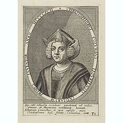
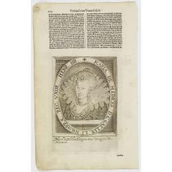
Christophorus Columbus Liguriensis Indiarum Primus Inventor Anno MCCCCXCII.
Portrait of Christopher Columbus (c. 31 October 1451 – 20 May 1506), explorer, colonizer, and navigator, born in the Republic of Genoa, in north-western Italy. Under the ...
Date: Antwerp, c.1700
Selling price: ????
Please login to see price!
Sold in 2023
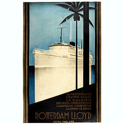
Rotterdam Lloyd, Royal Mail Line. La Méditerranée - L' Egypte - Ceylan - La Malaysie - Les Indes Néerlandaises - L' Australie - L' Indo-Chine - La Chine - Le Japon.
Johann von Stein made this iconic poster for the Rotterdam Lloyd in 1930. This is the rare French version for the tour from Rotterdam to Australia.Johann von Stein (Dutch...
Date: Rotterdam, 1930

Erfolgte Kapitulation zwischen dem General Bonaparte und den Gross Leister von Malta. Vor der Hauptstadt Walette zu Maltha, am 10 Juni 1798.
Copper engraving with three scenes and one portrait on one sheet. In upper a view of Bonaparte arriving at Valletta. Published in "Allgemeine Welt-Chronik oder neue ...
Date: Zittau, 1798-1800
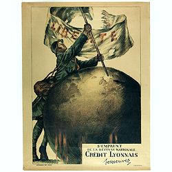
3e emprunt de la Défense nationale Crédit Lyonnais. Souscrivez.
Large color lithographed propaganda World War 1 poster. Designed by the illustrator Faivre Abel (1867-1945). A solder placing the French flag on a globe.English translati...
Date: Paris, 1917

Carte de L\'Egypte de la Nubie de L\'Abissinie. . .
Prepared by G.de l'Isle. Uncommon issue by Hendrik de Leth. Very detailed map of northeastern Africa, the Red Sea and the Arabian peninsula shows the political divisions ...
Date: Amsterdam, 1740
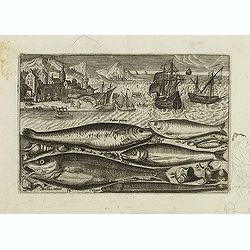
Faber piscis, Asellus minor, Conger, Alburinus. (Piscium Vivæ Icones - Fish)
Depiction of Faber piscis, Asellus minor, Conger, Alburinus. Fish set against a mountainous landscape in the manner of Pieter Brueghel the Elder. Plate number 14. The eng...
Date: Antwerp, after 1598
![[TAI travel poster]](/uploads/cache/44894-250x250.jpg)
[TAI travel poster]
A whimsical travel poster for "Transport Aeriens Intercontinentaux" (TAI), published in Paris in 1960, design by François Lesourt (Périgueux, 1913 - 1997). The ...
Date: Paris, Hubert Baille & Cie Paris, 1960
![[Portrait] Johannes Baptista Homann . . .](/uploads/cache/36599-250x250.jpg)
[Portrait] Johannes Baptista Homann . . .
Stunning full portrait of the Imperial Geographer of the Holy Roman Empire, Johann Baptist Homann (1664-1724) who was born in the Bavarian town of Kammlach. Educated at a...
Date: Nuremberg, c.1740
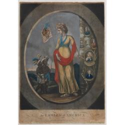
An Emblem of America / An Emblem of Africa / An Emblem of Asia / An Emblem of Europe.
An Emblem of America : This white female figure of Columbia, emblematic of the United States, represents America in a set of prints of the Four Continents. Standing besid...
Date: London, 1798

Carte de la Coste de La Rochelle a Brouaige et de l'Isle d'Oleron Observee par le S.r de Chattillon ingenieur du Roy.
Map of the island of Oléron, with an inset in lower left corner showing the route of an English fleet to La Rochelle. At the time of mapping the area was a stronghold of ...
Date: Paris, 1627

Entrée des forêts de la rivière Sedger. . .
Exquisite contemporary colored lithograph of Sedger's river in the Chili, with as seen by Dumont D'Urville's, with Indians. Drawn by Louis Le Breton, lithographed by Bich...
Date: Paris, 1846
![Province de Fo-Kien. [Includes West Coast of Taiwan]](/uploads/cache/43503-250x250.jpg)
Province de Fo-Kien. [Includes West Coast of Taiwan]
An important map of Fujian Province shows the East Coast of China and the West Coast of Taiwan. It shows that for the Manchu Qing, only the western half of Formosa was co...
Date: The Hague, H. Scheurleer, 1737
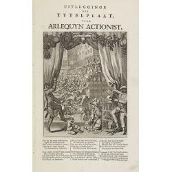
Uitlegginge der tytelplaat voor Arlequyn actionist.
Decorative print. Harlequin stockholder. The engraving (230x180mm.) depicts a kneeling conjuror with cups, balls and cards, Harlequin and Scaramouche drawing back curtain...
Date: Amsterdam, 1720

Pas-Kaat vaneen gedeelte van de Aethiopische Zee behelsende de Kusten Zanguebar, Ajan en Abex, en een gedeelte van de Arabische Kust. . .
A finely engraved and detailed chart of the most eastern tip of Africa, including Somalia, Djibouti, Yemen, Mauritius, and many other islands in the Indian Ocean.Very rar...
Date: Amsterdam, 1753
![.[Balkan region with Austria, Croatia, Slovenia, Switzerland, etc]](/uploads/cache/33858-250x250.jpg)
.[Balkan region with Austria, Croatia, Slovenia, Switzerland, etc]
Wood block printed map and one of earliest printed representation of Balkan with Austria, Croatia, Slovenia, Switzerland, etc prepared Martin Waldseemüller. Based on the ...
Date: Vienna, 1525 -1541

De Stadt Jerusalem.
Plan of ancient Jerusalem from a Dutch bible after Villalpando. The print is in contemporary colors, which is extremely rare for a plate like this. Lower left the Temple ...
Date: Amsterdam, 1710

Sumatra Insula.
A miniature map of Sumatra and the Malay Peninsula, including Singapore and the various islands directly south of it. Containing detailed geography and nomenclature aroun...
Date: Amsterdam, 1609
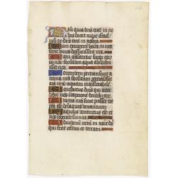
Leaf on vellum from a manuscript Book of Hours.
RECTO: One 2-lines initial decorated with flower in liquid gold on colored grounds and six 1-line initials in liquid gold on colored grounds and five line-fillers in same...
Date: France, ca. 1530

Guyenne - Gascogne.
Very decorative, informative map of Guyenne and Gascogne region in France. The map is filled with buildings, animals, figures and two locals. With a large compass rose in...
Date: France, 1943
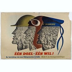
Één doel - Één wil. (Koninklijke Marine)
Poster on the Allied military cooperation published by the Dutch Military Government. ¨Poster with stylised portraits of an infantryman, airman and sailor, turned in prof...
Date: London, James Haworth & Brother LTD, 1944 - 1945
![Rhodi [Map of Rhodes]](/uploads/cache/45235-250x250.jpg)
Rhodi [Map of Rhodes]
Very rare map of Rhodes Island published in the first edition of "Viaggio da Venetia, a Costantinopoli. Per Mare, e per Terra, & infieme quello di Terra Santa. D...
Date: Venice, Giacomo Franco, 1598

(Untitled view from Scutari with a view of Constantinople)
Panoramic view from Scutari with a view of Constantinople in the distance, after a design by Johann Schranz. Published by J. Missiriè.
Date: Paris, 1860
![[East Asia]](/uploads/cache/33873-250x250.jpg)
[East Asia]
Wood block printed map and one of earliest printed representation of East Asia and centered on Amenia, prepared Martin Waldseemüller. Based on the slightly larger map fro...
Date: Vienna, 1525 -1541

Carte d'unne partie de l'Arabie Septentrionale Pour suivre les Voyages de Mr. G.A. Vallin. . .
This is the original hand-drawn map by Victor Adolphe Malte-Brun of "Carte d'unne partie de l'Arabie Septentrionale Pour suivre les Voyages de Mr. G.A. Wallin",...
Date: Paris, November 1855

Calendrier de la cour, tiré des éphémérides, pour l'Année bissextile.. / Notebook bearing silver plates with the VOC monogram.
A personal gift, only made for the trustees of the V.O.C. The silver plate was probably made by Drick van Hengel and Company because an entry in the diary of mintmaster J...
Date: Paris, 1787

III. Gallia. Franckrych.
Very early wood cut printed map of France, North of river Rhine, Northern Italy. Coast of England from Dover to Cornwall. A ship, sea monsters and coats of arms are filli...
Date: Zurich, Christoffel Froschover, 1548,1552-1566
Selling price: ????
Please login to see price!
Sold in 2025

Zee caerte vande Sondt tvermaerste van Danemarcke . . .
A detailed chart of the coast of Denmark and its islands, Copenhagen in the center of the chart. West to the top. It is decorated by a title, scale and descriptive cartou...
Date: Leiden, Plantijn, 1585
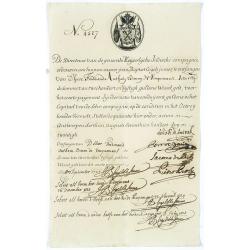
Very rare share in the Ostend Company. (4527)
Upper left hand corner share number 4527 in manuscript. In top emblem of the Ostend Company in copper engraving. Text: De Directeurs van de generale Keijserlijche- Indisc...
Date: Antwerp / Ostend 1723

Die Insel Formosa neu abgemessen auf Befehl Kaysers Kamhi.
One of the earliest obtainable printed maps of Taiwan or Formosa Island. It was issued around 1726 to illustrate Joseph Stöcklein's [Stoecklein] compilation of Jesuit mis...
Date: Augsburg, 1726

Ilse Paese de' Selvaggi.. Lago Superiore. (Florida and the Bahamas)
Antonio Zatta published an Italian version of the John Mitchell map in twelve sheet. This sheet depicts Lake Superior in the Bellin version, as it appeared on the Mitchel...
Date: Venice, 1778

Nieuwe Wassende Graadige Pas-kaart van de Kust van Guinea en Brasilia.
Rare two-sheet sea chart of the coasts of Brazil, West Africa and South Africa, published by Johannes Van Keulen (the younger), circa 1720.The chart shows the western coa...
Date: Amsterdam, 1751

XII. Laurater Basler gelegenheit.
Very early wood cut printed regional map of Switzerland with Basel region.Originally engraved in 1548. The map was prepared by Johannes Stumpf (1500-1576). Included in &q...
Date: Zurich, Christoffel Froschover, 1548,1552-1566
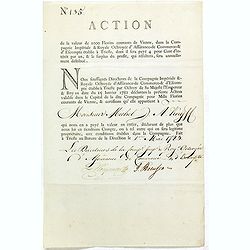
Share of 1000 Florins to Michel de Knyff. N° 135.
Share of 1000 Florins, paid in four tranches at 250 Florins of Vienna, from "Compagnie Imperiale & Royale Octroyee d'Assurance de Commerce & d'escompte."...
Date: Trieste, 1782 - 1783

French Line CGT Poster.
French Line CGT Poster showing the Normandie cruise ship travelling from Southampton to New York, advertising an express luxury service on both the Ile de France and the ...
Date: England, ca. 1936
Art déco label Biette Savon - Tein de fleur.
Lithographed perfume label " Biette Savon - Tein de fleur" laid on original cardboard sheet. A striking example of commercial artworks produced by the artist an...
Date: Paris, between 1925 and 1930

Insularum Moluccarum Nova description.
Exquisite map of the famous Spice Islands based. This map was the first large-scale map of the region and depicts the islands which provided first the Portuguese and then...
Date: Amsterdam, 1730

Histoire de la Guerre Civile en Amerique par M. Le Comte de Paris, Ancien Aide de Camp du General Mac Clellan (McClellan). ...
The maps are chromolithographs and offer a fascinating view of the Civil War battlegrounds. Vorzet made these 30 maps to accompany Louis Phillipe d'Orleans' (Comte de ...
Date: Paris. Michel Levy Freres, 1875
Maria De Medices D. G Galliae et Navarrae Reg. Uxor Henr. IIII.
The engraving depicts a half length oval portrait of Marie de' Medici, queen consort of France .Nicolaes de Clerck (de Klerc) was active as engraver and publisher in Delf...
Date: Amsterdam, Cloppenburch, 1621
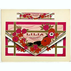
Art déco label Paul Tranoy, Paris.
Lithographed perfume label " Lilia Savon extra fin soap - Œillet (carnation) Paul Tranoy Paris N°725 " laid on original cardboard sheet. A striking example of c...
Date: Paris, between 1925 and 1930
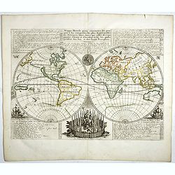
Mappe-Monde pour connoitre les progres & les conquestes..
Unusual double hemisphere map with California as an Island. Dutch text describes the expeditions and colonial possessions of the Dutch East India Company. The map origina...
Date: Amsterdam, 1729

Carte de L'Archipel de La Recherche a la partie Occidentale de la Terre de Nuyts. . .
A large and detailed chart of the southern West Australian coast centered on the region of Esperance and the surrounding islands.Terre de Nuyts is the name that was forme...
Date: Paris 1807

Manuscript plan of Havana harbour.
Manuscript chart with good nautical detail and soundings of Havana harbour.
Date: Spain c.1820

Plan du Port de St Augustin dans la Floride.
This chart shows a plan of the Port of St. Augustine in Florida.The only issue of this version of Bellin's map, slightly larger than the common version. Depths shown by s...
Date: Paris, 1764
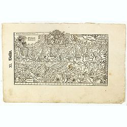
XI. Wallis.
Very early wood cut printed regional map of Switzerland with Wallis region.Originally engraved in 1548. The map was prepared by Johannes Stumpf (1500-1576). Included in &...
Date: Zurich, Christoffel Froschover, 1548,1552-1566
Quinta Etas Mundi. Folium. LXVI. (Visionary Temple of Ezekiel.)
The Latin text page is illustrated with recto and verso depictions of the visionary Temple of Ezekiel. Kings.Page from the richest illustrated Incunable, the famous: Chro...
Date: Nuremberg, 12 July 1493

Carte de la Manche. . .
Decorative chart showing the Chanel, with the coastline of France from La Baie de Douarnenez to Dunkerque, and the coastline of England from Stroble head to Manning Tree....
Date: Amsterdam, 1692

Carte de l'Ile de Java.
An inset plan of Batavia and clearly indicated rice fields, mountains, forests, towns in profile and even elephants suggest the wealth of detail found on this map. Modele...
Date: Amsterdam, 1720
![.[Near east with Cyprus]](/uploads/cache/33857-250x250.jpg)
.[Near east with Cyprus]
Wood block printed map and one of earliest printed representation of Near east with Cyprus prepared by Martin Waldseemüller. Based on the slightly larger map from 1513 pu...
Date: Vienna, 1525 -1541

Nieuwe en zeer accuraate Zee-Caart van de Hollandse Wal strekkende van de Maas tot Texel opgenomen door Jan Rokusz Douw, , ,
A very fine and rare chart of the coast of Holland, Prepared by Jan Rokusz, Douw and Agge Roskam Kool.Embellished with a very decorative cartouche with a dedicational tex...
Date: Amsterdam, 1750

Irlandiae Regnum.
A very nice map from Ireland.Mercator was born in Rupelmonde in Flanders and studied in Louvain under Gemma Frisius, a Dutch writer, astronomer, and mathematician. The ex...
Date: Amsterdam, 1630
Terra Firma et Novum Regnum Granatense et Popayan.
A handsome map of modern-day Panama and Colombia. The cartouches and decoration are colored in an artistic way. Very fine and rare with this type of coloring.From "l...
Date: Amsterdam, 1635-1638
![Schat-Kamer ofte konst der stuurlieden, behelzende een duidelyke onderwyzinge in de navigatie. . . [bound with] Tafelen bevattende De Sinussum, tangenten en Secanten. . . [bound with] Geographische Tadfel...](/uploads/cache/33112-250x250.jpg)
Schat-Kamer ofte konst der stuurlieden, behelzende een duidelyke onderwyzinge in de navigatie. . . [bound with] Tafelen bevattende De Sinussum, tangenten en Secanten. . . [bound with] Geographische Tadfel...
Schat-Kamer ofte konst der stuurlieden, behelzende een duidelyke onderwyzinge in de navigatie. . . [bound with] Tafelen bevattende De Sinussum, tangenten en Secanten. . ....
Date: Amsterdam, J. v. Keulen en Zoonen, 1777

Het Canaal tusschen Engeland en Vranciick.
An eye-catching chart of the Channel.Pieter Goos (ca. 1616-1675) was one of the most important cartographers, engravers, publishers and print sellers of Amsterdam. His wi...
Date: Amsterdam, after 1666

L'Homme A La Boule.
Satirical print in which Count Otto von Bismarck balances on the world with one spurred foot entering France, and wearing only his underpants which are marked with the Ge...
Date: Paris, 1870-1871
