Sign In or Sign Up
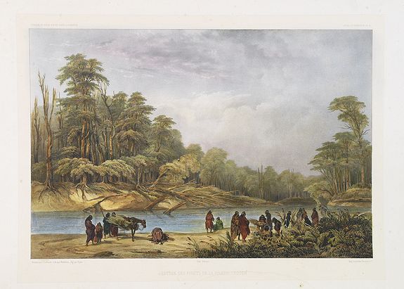
Entrée des forêts de la rivière Sedger. . . |
||||||||||||||||||||
|
||||||||||||||||||||
|
|
||||||||||||||||||||
$200 / ≈ €175This item is available for immediate sale! Questions before Buying ?
We are happy to answer your questions.
200.00
|
My Collection +
Add this or any of your favorite items in one place. If you want to save the items permanently, you have to sign in or create an account first. |
|||||||||||||||||||
Description
Exquisite contemporary colored lithograph of Sedger's river in the Chili, with as seen by Dumont D'Urville's, with Indians. Drawn by Louis Le Breton, lithographed by Bichebois and Bayot. From the "Atlas Pittoresque" that accompanied the massive volumes Voyage au pole sud et dans l'Oceanie, published by Gide from 1841-1854 about Dumont d'Urville's voyage to the South Pole and the South Pacific.
On the voyage of 1837, Dumont d'Urville was asked by King Louis-Philippe to explore the South Pole. The main focus of the voyage was to reach Antarctica "towards the Pole as far as the polar ice will permit" (Rosenman, 1992, p. 110).
He sailed into the South Atlantic, to the Straits of Magellan, then further south to the Antarctic, reaching 63° latitude south until the ice, fog and snow prevented them from going any further. Valuable data was obtained on these unknown regions, but at the cost of an outbreak of scurvy. Of the 183 men on board the two ships, 22 did not make it back alive.
Dumont d'Urville then sailed to Chile to refresh supplies and allow the men the chance to recover. From Chile he sailed across the Pacific, visiting the Marquesas, Tahiti, Samoa, Tonga, Fiji, the Solomons, the Carolines and New Guinea. The expedition then did a circuit around Indonesia and South East Asia before sailing down the west coast of Australia to Hobart, Tasmania.
Once summer returned, Dumont d'Urville decided to make another push for the Antarctic. On 19 January 1840, land was sighted and Dumont d'Urville named it Terre Adélie, after his wife.
Samples of rock were taken to prove that it was a continent, and the French flag was flown. Discovering and claiming Terre Adélie in Antarctica for the French was strategically and politically Dumont d'Urville's most significant achievement.
FAQ - Guarantee - Shipping
Buying in the BuyNow Gallery
This item is available for immediate purchase when a "Add to Cart" or "Inquire Now" button is shown.
Items are sold in the EU margin scheme
Payments are accepted in Euros or US Dollars.
Authenticity Guarantee
 We provide professional descriptions, condition report (based on 45 years experience in the map business)
Paulus Swaen warrants the authenticity of our items and a certificate of authenticity is provided for each acquired lot.
Condition and Coloring
We indicate the condition of each item and use our unnique HiBCoR grading system in which four key items determine a map's value: Historical Importance, Beauty, Condition/Coloring and Rarity.
Color Key
We offer many maps in their original black and white condition. We do not systematically color-up maps to make them more sellable to the general public or buyer.
Copper engraved or wood block maps are always hand colored. Maps were initially colored for aesthetic reasons and to improve readability. Nowadays, it is becoming a challenge to find maps in their original colors and are therefor more valuable.
We use the following color keys in our catalog:
Original colors; mean that the colors have been applied around the time the map was issued.
Original o/l colors; means the map has only the borders colored at the time of publication.
Colored; If the colors are applied recently or at the end of the 20th century.
Read more about coloring of maps [+]
Shipping fee
A flat shipping fee of $ 30 is added to each shipment by DHL within Europe and North America. This covers : International Priority shipping, Packing and Insurance (up to the invoice amount).
Shipments to Asia are $ 40 and rest of the world $50
We charge only one shipping fee when you have been successful on multiple items or when you want to combine gallery and auction purchases.
Read more about invoicing and shipping
FAQ
Please have a look for more information about buying in the BuyNow gallery
Many answers are likely to find in the general help section.
My Collection+
![]()
With My Collection+ you can collect all your favorite items in one place. It is free, and anyone can create his or her virtual collection.
Unless you are logged in, the item is only saved for this session. You have to be registed and logged-in if you want to save this item permanently to My Collection+.
Read More[+]
Register here, it is free and you do not need a credit card.
Add this item to
My Collection+
or click the following link to see My Collection+.
| Digital Image Download | |
|
Paulus Swaen maintains an archive of most of our high-resolution rare maps, prints, posters and medieval manuscript scans. We make them freely available for download and study. Read more about free image download |
Click the image for a free small image download. |
In accordance with the EU Consumer Rights Directive and habitually reside in the European Union you have the right to cancel the contract for the purchase of a lot, without giving any reason.
The cancellation period will expire 14 calendar days from the day after the date on which you or a third party (other than the carrier and indicated by you) acquires, physical possession of the lot. To exercise the right to cancel you must inform Paulus Swaen Inc, of your decision to cancel this contract by a clear statement (e.g. a letter sent by post, or e-mail.
To meet the cancellation deadline, it is sufficient for you to send your communication concerning your exercise of the right to cancel before the cancellation period has expired.
Recently Viewed

Entrée des forêts de la rivière Sedger. . .
Exquisite contemporary colored lithograph of Sedger's river in the Chili, with as seen by Dumont D'Urville's, with Indians. Drawn by Louis Le Breton, lithographed by Bich...
Date: Paris, 1846
