Sign In or Sign Up
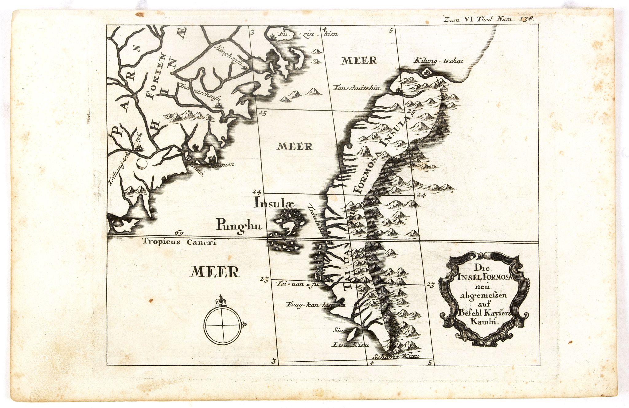
Die Insel Formosa neu abgemessen auf Befehl Kaysers Kamhi. |
||||||||||||||||||||
|
||||||||||||||||||||
|
|
||||||||||||||||||||
$900 / ≈ €791This item is available for immediate sale! Questions before Buying ?
We are happy to answer your questions. |
My Collection +
Add this or any of your favorite items in one place. If you want to save the items permanently, you have to sign in or create an account first. |
|||||||||||||||||||
Description
One of the earliest obtainable printed maps of Taiwan or Formosa Island. It was issued around 1726 to illustrate Joseph Stöcklein's [Stoecklein] compilation of Jesuit missionary letters "Allerhand So Lehr-als Geist-reiche Brief, Schrifften, und Reis-Beschreibungen".
The map shows the western part of Taiwan, the Pescadores (Penghu) Islands, and China's Fuzhou (Fujian) coast. Several ancient Taiwanese cities are noted, including Keelung, Tainan, and possibly Kaohsiung.
Like most early maps of Taiwan, only the Chinese portion, west of the Central Mountain Range (Zhongyang Range or Chungyang Range), offers significant detail. Here, the tribal lands east of the Central Range are neglected and fade into the unknown. Another curiosity is the cartographer's decision to ghost in an extended Taiwan coastline leading north of Keelung. This gives evidence of just how little was known of Taiwan at the time.
Stöcklein's work is a compound of letters of the Jesuit missionaries from all over the world and here, particularly the ones stationed at the court of the Emperor Kamhi. This Emperor ordered the priests, known by their names as Pater (Father) Regis, Hinderer, and de Mailla, to survey his empire, including his territories on the island of Formosa.
The map also shows Danshui county (port here), where the Portuguese were located before the Dutch, near where Taipei city is now.
The Jesuits who made these maps were doing it for Emperor Kangxi, the greatest Qing emperor, 1661-1722. He became emperor as a child. Expanded Chinese territory to Taiwan, Tibet and Mongolia.
More about Taiwan or Ilha-Formosa maps. [+]
Reference: The Authentic Story of Taiwan, page 120, OAG, Japan a cartographic vision, plate 95.
FAQ - Guarantee - Shipping
Buying in the BuyNow Gallery
This item is available for immediate purchase when a "Add to Cart" or "Inquire Now" button is shown.
Items are sold in the EU margin scheme
Payments are accepted in Euros or US Dollars.
Authenticity Guarantee
 We provide professional descriptions, condition report (based on 45 years experience in the map business)
Paulus Swaen warrants the authenticity of our items and a certificate of authenticity is provided for each acquired lot.
Condition and Coloring
We indicate the condition of each item and use our unnique HiBCoR grading system in which four key items determine a map's value: Historical Importance, Beauty, Condition/Coloring and Rarity.
Color Key
We offer many maps in their original black and white condition. We do not systematically color-up maps to make them more sellable to the general public or buyer.
Copper engraved or wood block maps are always hand colored. Maps were initially colored for aesthetic reasons and to improve readability. Nowadays, it is becoming a challenge to find maps in their original colors and are therefor more valuable.
We use the following color keys in our catalog:
Original colors; mean that the colors have been applied around the time the map was issued.
Original o/l colors; means the map has only the borders colored at the time of publication.
Colored; If the colors are applied recently or at the end of the 20th century.
Read more about coloring of maps [+]
Shipping fee
A flat shipping fee of $ 30 is added to each shipment by DHL within Europe and North America. This covers : International Priority shipping, Packing and Insurance (up to the invoice amount).
Shipments to Asia are $ 40 and rest of the world $50
We charge only one shipping fee when you have been successful on multiple items or when you want to combine gallery and auction purchases.
Read more about invoicing and shipping
FAQ
Please have a look for more information about buying in the BuyNow gallery
Many answers are likely to find in the general help section.
My Collection+
![]()
With My Collection+ you can collect all your favorite items in one place. It is free, and anyone can create his or her virtual collection.
Unless you are logged in, the item is only saved for this session. You have to be registed and logged-in if you want to save this item permanently to My Collection+.
Read More[+]
Register here, it is free and you do not need a credit card.
Add this item to
My Collection+
or click the following link to see My Collection+.
| Digital Image Download | |
|
Paulus Swaen maintains an archive of most of our high-resolution rare maps, prints, posters and medieval manuscript scans. We make them freely available for download and study. Read more about free image download |
Click the image for a free small image download. |
In accordance with the EU Consumer Rights Directive and habitually reside in the European Union you have the right to cancel the contract for the purchase of a lot, without giving any reason.
The cancellation period will expire 14 calendar days from the day after the date on which you or a third party (other than the carrier and indicated by you) acquires, physical possession of the lot. To exercise the right to cancel you must inform Paulus Swaen Inc, of your decision to cancel this contract by a clear statement (e.g. a letter sent by post, or e-mail.
To meet the cancellation deadline, it is sufficient for you to send your communication concerning your exercise of the right to cancel before the cancellation period has expired.
Recently Viewed

Die Insel Formosa neu abgemessen auf Befehl Kaysers Kamhi.
One of the earliest obtainable printed maps of Taiwan or Formosa Island. It was issued around 1726 to illustrate Joseph Stöcklein's [Stoecklein] compilation of Jesuit mis...
Date: Augsburg, 1726
