Popular Listings
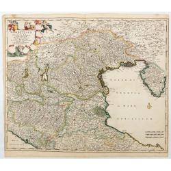
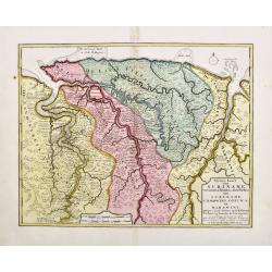
Accuratissima Dominii Veneti in Italia..
Detailed and decorative map centered on Venice, Vicenze, Mantova, Parma and Bologna, extending from Stato di Milano and Genoa to Istria. Decorative title cartouche in upp...
Date: Amsterdam, c. 1690

Walachia Servia, Bulgaria, Romania.
The cartographer of this map was Gerard Mercator. This attractive map of the Eastern Balkans is centered on Bulgaria and includes the Bosphorus and Constantinople. The Da...
Date: Oxford, 1680
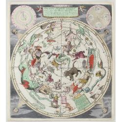
Nieuwe Hemels Spiegel waer door den hemel, aerde en zee dadelik kan afgemeten werden. Noyt gesien en dat op alles Polus hooghten seer noodig voor Stierlieden.
Copper engraving made by Andreas van Luchtenburg in Rotterdam, published separately by Cornelis Danckerts. We see the starry sky as observed from the northern hemisphere...
Date: Danckerts, ca. 1700
Algemeene kaart van de Colonie of Provintie van Suriname : met de rivieren, districten, ontdekkingen door militaire togten. . .
1740 DE LETH, H. - Large-scale map of Suriname, a record of one of the most important early Jewish communities in the Americas.
Date: Amsterdam, 1740
![[Rare double hemisphere celestial chart]](/uploads/cache/41404-250x250.jpg)
[Rare double hemisphere celestial chart]
Rare double hemisphere celestial chart, published by Jollain in 1667. Published in "Trésor Des Cartes Geographiques Des Principaux Estats de Lunivers".This atla...
Date: Paris, 1667
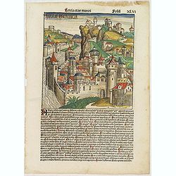
Tercia Etas Mundi. Folium.XLVI (An English town view)
Large woodcut depicting an imaginary English town (235x223mm.) and on the verso the genealogy of King David.Page from the richest illustrated Incunable, the famous: Chron...
Date: Nuremberg, 12 July 1493
(Set of 4 maps) Itinéraire de Pékin à Sartchy
Set of 4 geological maps from the "Nouvelle Archives du Museum" printed by Becquet.1) Route de Pekin a Suen-Hoa-Fou2) Route de Thae-Seu-Tchouang aux tentes mong...
Date: Paris, ca. 1880

Russia & Poland.
Charming, folding map of Russia and Poland, giving a detailed overview of Europe from Baltic to Caspian Sea. Railways and rivers prominently delineated.In lower left a ke...
Date: London, ca. 1890

Tabula Secunda Europe (Spain & Portugal)
Wood block printed large-format Ptolemaic map of the Iberian Peninsula from the 1513 edition of Waldseemüller's Geographia.This Ptolemaic map comes from the first so call...
Date: Strasburg, 1513
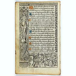
Leaf on vellum from a printed Book of Hours.
21 lines of printed text, surrounded by renaissance borders decorated with flowers, vases, religious scenes and a figure symbolizing the Danse Macabre consists of the dea...
Date: Paris, Germain Hardouyn, c.1520-1540

Leaf on vellum from a antiphonary.
A leaf from a Medieval Antiphonal or Choir Missal for Spanish use, in Latin on extremely heavy vellum. Justification: 360x246mm. Text is in Spanish rounded gothic hand (R...
Date: Sevilla, ca.1520
La Ville et le Château de Zélandia dans l' île de Tayovan.
This important copperplate engraving is one of the earliest European views of Taiwan, depicting the Dutch fortifications and trading settlement on the West coast of the i...
Date: Amsterdam, 1675
De Reede en stadt Batavia is geleegen aan de Noord Kust…
A chart of the bay of Batavia with in lower left corner a plan of Batavia (120x147mm). This very rare and influential chart gives a fine representation of Batavia, now kn...
Date: Amsterdam, 1728
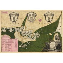
Nieuwe kaart van Suriname vertonende de stromen en land-streken van Suriname, Comowini, Cottica en Marawini, gelegen in Zuid America op de kusten van Caribana. . .
Decorative full color example of Ottens' map of Suriname. Detailed map of the northeast part of Suriname between Paramaribo, with fort Zeelandia, and Mana.Along the Surin...
Date: Amsterdam, ca. 1713-1718
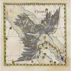
Cygnus.
Uncommon celestial print of Cygnus, published by Corbinianus Thomas in the Manuductio ad Astronomiam, Juxta modum Bayeri, Mathematici celeberrimi, concinnata, multis,…edi...
Date: Frankfurt / Leipzig, c.1730
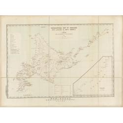
Topographical map of Hokkaido with localities of useful minerals.
Bilingual (English/Japanese) topographic map (1:1,500,000) of Hokkaido Island detailing the distribution of mineral deposits and mining sites (“useful minerals”), publish...
Date: Hokkaidōchō (Gouvernement de Hokkaidō), Sapporo, 1891
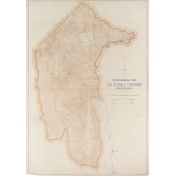
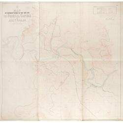
Topographical map of the Federal Territory, Australia.
This map, published by the New South Wales Department of Lands in Sydney in 1910, depicts the Federal Territory—the area designated to house Australia’s future federal ca...
Date: Sydney, Dept. of Lands, 1910
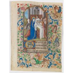
Miniature of the Presentation of Jesus at the Temple.
Page from a Book of Hours, use of Rome, with a large miniature set in full borders, by the Maitre François sub-group of Parisian artists of the middle of the second half ...
Date: Paris ca. 1470
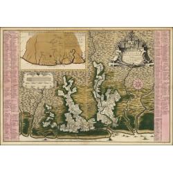
Naaukeurige Platte Grond van den Staat en den Loop van Rio de Berbice Met derzelver Plantagien in de Geoctrojeerde Colonie de Berbice Gelegen. . .
Uncommon large-scale map of Berbice with Rio de Berbice and Rio de Canje, with at the bottom left a list of plantation owners. In the top 3 x 3 coats of arms in cartouche...
Date: Amsterdam, 1740
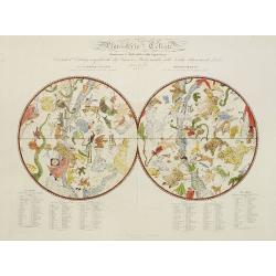
Planisferio Celeste contenente le stelle dalla 1 alla 5 grandezza. . .
Decorative large double hemisphere celestial chart, centred on the north and south poles with descriptive key to zodiac signs in German, French and Italian. Showing stars...
Date: Milan, c.1822
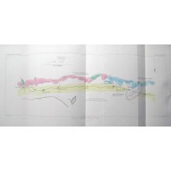
Canberra Contour Survey.
An important large-scale folding map by Charles Scrivener of the present-day city of Canberra, featuring contour lines and elevation data, created as part of the prelimin...
Date: Department of Lands, Sydney N.S.W. July, 1909
Map of contour survey of the site for the federal capital of Australia.
Map of contour survey of the site for the federal capital of Australia / drawn on stone by Messrs. O. Fischer and A.G. von Stach under direction of E.S. Vautin ; drawn on...
Date: Department of Lands, Sydney, 1910
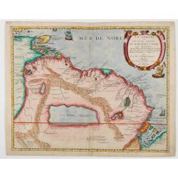
La Guaiane ou Coste Sauvage, autrement El Dorado, et Pais des Amazones…
An extremely rare edition of Du Val's map, separately published by Jollain in 1668, that references the name "El Dorado" in its title. The title translates as f...
Date: Paros, Chez Jollain, 1668
Carte des Isles Nicobar... (with) Plan particulier du Port compris entre les Isles Nacaveri, Souri, et Tricutte.
French chart of Isles of Nicobar in Gulf of Bengal near Birmanie and Sumatra. Prepared by Jacques-François L'Abbé Dicquemare (1733-1789). Latitude and longitude scales, c...
Date: Paris, Brest, chez Demonville, 1775
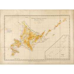
Mountain system of Hokkaido.
Bilingual English/Japanese map of Hokkaido showing elevations, volcanoes and roads for geological observations, with an inset of Chishima (Kuril Islands).
Date: Hokkaidōchō (Gouvernement de Hokkaidō), Sapporo, 1892
Cycloramic view of Canberra capital site, view looking from Camp Hill / … view looking from Vernon.
Showing an extensive panoramic view of the site of Canberra with various features named. Very large colour photo-mechanical print. Printed by John Sands Ltd [Syd].This 5 ...
Date: Sydney, John Sands, 1911
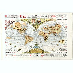
Index Geographicus Tum veteristum novae cognitae Terrae. . .
This rare and decorative advertising poster uses the world map by Presbyter Chrysanthos, who was the Patriarch of Jerusalem. In the top we see John Constantine Bessaraba ...
Date: Paris, ca. 1930
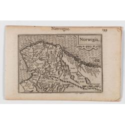
Norwegia.
An attractive and important miniature map Norway. The map is orientated to the west. The earliest map showing Norway.Prepared by Petrus Bertius, published in Amsterdam at...
Date: Amsterdam, 1606
Nova Maris Caspii et Regions Usbeck. . .
This is the first printed map specifically of the Uzbek region. It shows the area around the Caspian Sea and northern Iran. The area eastward from the Caspian is marked '...
Date: Nuremberg, 1735

A chart of the northern part of the Indian Ocean..
Complete title in upper right "A Chart of the Northern Part of the Indian Ocean, Containing a Part of the Coast of Africa from Magadasho River to the Straits of Bab-...
Date: London 1794
![[Lot of 10 leaves] Catalogus doctorum…in Cosmographia Sebastiani…/ Index Cosmographicus.](/uploads/cache/48294-250x250.jpg)
[Lot of 10 leaves] Catalogus doctorum…in Cosmographia Sebastiani…/ Index Cosmographicus.
Ten leaves with several wood blocks with an index taken from the "Cosmographia". From the 1552 Latin text edition of Münster's Cosmographia, which is a short an...
Date: Basel, 1552
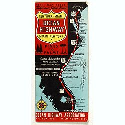
New York - Miami Ocean Highway. Pines to Palms. - Ocean Highway Official Highway Route Approved and Sponsored by the Ocean Highway Association.
Vintage road map showing "The Route of the Experience Motorist" features mileage information in the right margin. Verso features information on cities along the...
Date: Washington, ca. 1947
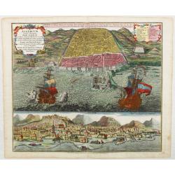
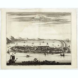
Algercum munita Metropolis Regni Algeriani…
Scarce bird's-eye plan of Algiers and its harbor, with two large galleons, and a panoramic view below, from "Atlas Novus", engraving with very fine, strong hand...
Date: Augsbourg, 1730
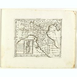
L'Italia Settentrionale presa da quella del Sig. Zannoni.
Rare map of Italy with inset map with Corsica and Sardinia, from "Atlante Novissimo ad uso Dei Giovani Studiosi Contenuto In Carte XXVII.", published by Giovann...
Date: Rome, 1780
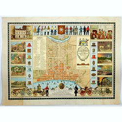
A Map of the City of Philadelphia, showing the Location of the Volunteer Fire Companies. . .
A fine, large pictorial plan of the City of Philadelphia, based on the drawing by Jacob Riegel in 1937, which itself was based on an earlier work dating back to 1794. The...
Date: Philadelphia, 1938
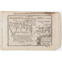
Nova Guinea et In. Salomonis
Early miniature map of New Guinea from the Caert-Thresoor and engraved by the Dutch master-engraver Petrus Kaerius. The first edition was printed in Middelburg by Barent ...
Date: Amsterdam, 1606
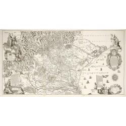
Diocesi Padovana Con Tutta La Sua Estensione Ne Vicini Territori.
This large map depicts the entire extent of the Diocese of Padua and the surrounding territories, with a detailed topographical rendering. It features rich Baroque ornam...
Date: Padova, 1720
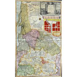
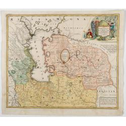
Potentissimo Borussorum Regi Friderico Wilhelmo...
Large and sought-after 2-sheet map of an area of Lithuania and Eastern Prussia (Russian province of Kaliningrad) stretching from Klaipeda (Memel) in the north to Goldap i...
Date: Nuremberg, 1735
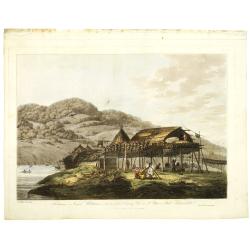
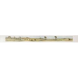
Balagans or summer habitations, with the method of drying fish at St. Peter and Paul, Kamtschatka.
Balagans or summer habitations, with the method of drying fish at St. Peter and Paul, Kamtschatka, taken from "Views in the South Seas" being a very important a...
Date: London, Boydell and Co., 1808
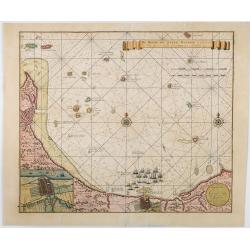
![Baltick or East Sea]](/uploads/cache/49464-250x250.jpg)
Baltick or East Sea]
A Chart of the Baltic or East Sea. Gulf of Finland & c. (date ca.1730). Image size: 357mm x 283mm.Herman Moll (1678-1732) was a German emigre from the Hanseatic port...
Date: London, ca. 1720-1730
![Planisphere celeste Septentrional. . . [together with] Planisphere celeste meridional. . .](/uploads/cache/35291-250x250.jpg)
Planisphere celeste Septentrional. . . [together with] Planisphere celeste meridional. . .
Beautiful set of celestial charts of the northern and southern skies by the well-known French astronomer, Philippe de La Hire. Surrounded by panels of astronomical notes ...
Date: Paris, ca.1775
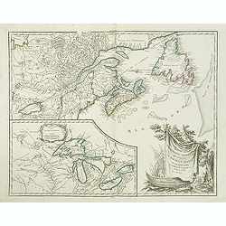
Carte Reduite, des Cotes De L'Acadie, de L'Isle Royale, et de la Partie Meridionale de L'Isle de Terre Neuve.
An important chart of Nova Scotia, southern Newfoundland and the Grand Banks, prepared after Chabert's voyage to Canada to update the French charts of Eastern Canada. It ...
Date: Paris, 1753
Anglia Regnum.
Janssonius' map of England and Wales was one of the new maps prepared by him in 1636. His map closely copies the similar map issued two years earlier by Willem Blaeu.. Th...
Date: Amsterdam, 1642
Mappamondo.
Rare world map from "Atlante Novissimo ad uso Dei Giovani Studiosi Contenuto In Carte XXVII.", published by Giovanni Zempel in Rome, ca. 1780.The map is based o...
Date: Rome, 1780

Pas kaart vande Zuyd kust van Cuba en van Geheel Jamaica…
A nautical chart covers the southern part of Cuba, Jamaica, the western tip of Hispaniola, and some Honduran coastline. Insets of "Baya Oristan in Yamaica ent Groodt...
Date: Amsterdam, J. van Keulen, 1697-1709
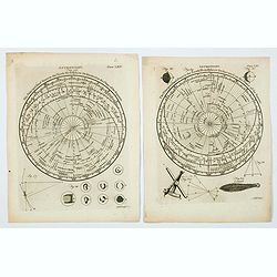
Astronomy. Figures 26 & 29. Plates LXV & LXV.
A lovely pair of copperplate astronomical plates displaying "The Principal fixed Stars in the North Hemisphere [and the South Hemisphere] Delineated on the Plane of ...
Date: London, 1792
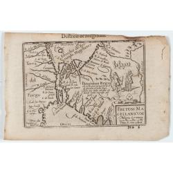
Fretum Magellanicum / Detroit de Magellan.
Early nice map of the South American extremity with the Strait of Magallanes, discovered by Ferdinand Magellan ( c. 1480 – 27 April 1521). Two natives holding a shield an...
Date: Amsterdam, 1606
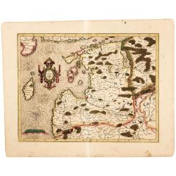
Latvia/ Estonia. Livonia.
A beautifully engraved map of Livonia – modern Latvia and Estonia – produced by two of the great fathers of modern cartography. Included are parts of the Baltic coasts of...
Date: Amsterdam, 1595-1609

Xantung, sinarum imperii provincia quatra.
A map of the northern province ‘Xantung’ of China after the Jesuit Martino Martini. Shows the Great Wall and is centered on the Bohai Sea, and the Shandong and Liaoning P...
Date: Amsterdam, ca 1660
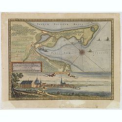
Neoburgum Fioniae oppidum. . .
Decorative plan and panoramic view of the town of Nyborg in Denmark at the coast of Baltic Sea in Fyn. Prepared by Count Erik Jönsson Dahlberg[h] (1625-1703). Military en...
Date: Stockholm, 1697
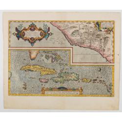
Hispaniolae, Cubae Alliarumique Insularium
Two maps on one sheet: one of the Viceroyalty of Culiacan in Northwestern Mexico and one of the Caribbean. Based on Mercator's 1569 world map, Guttierez' America map of 1...
Date: Antwerp, 1609
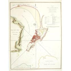
A Plan of the city and harbour of Macao : a colony of the Portugueze, situated at the southern extremity of the Chinese Empire. . .
A large chart of Macao engraved by Benjamin Baker (fl. 1766-1824) and published by George Nicol. The town of Macao is shown in detail, with a 37-point key in English list...
Date: London, 1796
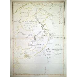
A Chart, on Mercator's Projection, Containing the Track and Soundings of the Lion, the Hindostan and Tenders, from Turon-Bay in Cochin-China. . .
A chart engraved by Baker and published by Nichol, this large chart traces the routes of the Lion, Hindostan, and Tenders with considerable detail. The chart was part of ...
Date: London, 1796
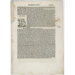
Sexta etas Mundi. Folium. CCXLV
The Latin text page is illustrated with a depiction of two lovers who happened to have lived in Italy: a knight named Eurialus, who was the personal attendant of Emperor ...
Date: Nuremberg, 12 July 1493

Paradigma XV Provinciarum et CLV Urbium Capitalium Sinensis Imperij Cum Templis quae Cruce X Signatur Et Domiciliis S.I.
First edition of this rare Jesuit map of China, published by Jean Baptiste Nolin in Paris and based on Philippe Couplet's map of 1686. The map shows China's 15 provinces ...
Date: Paris, 1686

Xantung, sinarum imperii provincia quatra.
A map of the northern province ‘Xantung’ of China after the Jesuit Martino Martini.Shows the Great Wall and is centered on the Bohai Sea, and the Shandong and Liaoning Pr...
Date: Amsterdam, ca 1660
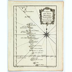
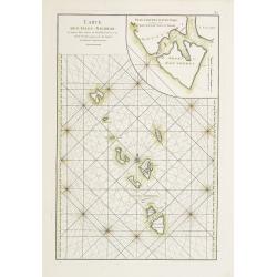
Carte des Isles Maldives.
A small detailed map of the Maldives, with rhumb lines and a large compass rose. Includes a decorative title cartouche. One of the maps produced by Nichlas Bellin for Pre...
Date: Paris, 1757

Iunan, Queichev, e Quangsi Provincie della Cina. . .
A beautiful map depicting the area of Beijing with decorative title cartouche and scale cartouche. Information about the area at the top of the map.The remarkable Vincenz...
Date: Venice, 1690
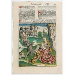
Prima Etas Mundi. IX
A very fine presentation of Eve nursing Kain and Abel. Adam is working (255x220 cm). VERSO: A Genealogy of Adam.Page from the richest illustrated Incunabel, the famous Li...
Date: Nuremberg, 12 July 1493
Partie de l'Amerique septent? Qui comprend la nouvelle France. . .
A fine copy of this map of New Foundland, Nova Scotia and the course of the St.Lawrence to Lake Ontario in a forth state.An inset shows Bellini's famous and important map...
Date: Paris, 1755-1778
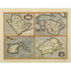
Anglesey. / Iarsay. / Carnesay. / Wight Vectis Olim.
Four maps on one sheet depicting the English islands Jersey, Guernsey, Wright and Alderney.
Date: Amsterdam, 1629
![[Magazine including pictorial world map, Carriers of the New Black Plague by William Cotton.]](/uploads/cache/43680-250x250.jpg)
[Magazine including pictorial world map, Carriers of the New Black Plague by William Cotton.]
Front cover with color illustration of a Moroccan male sheik and yellow lettering.Oversized magazine, features analysis of English justice, map of Herr Hitler's heaven (f...
Date: Chicago, April 7th, Vol.1 No.1 1938

(Publicity poster) Amer Besset Sans Rival.
Original chromo-lithographed in-store display for alcoholic drink Amer Besset. Printed by Joseph-Charles in Paris.
Date: Paris, ca.1933
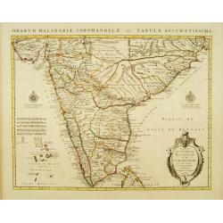
Carte des Côtes de Malabar et de Coromandel Presentée au Roy. . .
Large and attractive map of the Indian coasts of Malabar and Coromandel, embellished with title cartouche and 2 compass roses. It shows the most northern part of Ceylon.T...
Date: Amsterdam c. 1745
![Carthage, etc. [Foliu XL ] Carthage in Tunisia](/uploads/cache/26122-250x250.jpg)
Carthage, etc. [Foliu XL ] Carthage in Tunisia
1493 SCHEDEL, H. - Imaginary view of Carthage in Tunisia from the famous Liber chronicarum by Hartmann-Schedel
Date: Nuremberg 12 July 1493
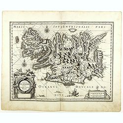
Tabula Islandiae. . .
With a very decorative cartouche and a very fine imprint. No text on verso; included in the rare "Appendix" of 1630. VERY RARE. This handsome map of Iceland was...
Date: Amsterdam, 1630
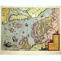
Septentrionalium Regionum Descrip.
1584 ORTELIUS, A. - Scandinavia, Iceland, Greenland and part of the North American continent, includes also the legendary islands of i.a. Drogeo, Frisland and Icaria.
Date: Antwerp, 1584
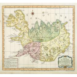
Carte de l'Islande pour servir á la continuation de l'histoire générale des voyages. Dressée sur celle de M. Horrebows.
A good engraved map of the island Iceland, prepared by Bellin after M. Horrebows, with rococo title cartouche in lower right. From l'Histoire générale des voyages.
Date: Paris, 1758
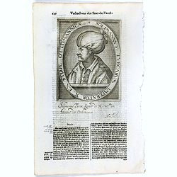
Solimannus Turcarum Imperator X. Ex Stirpe Ottomannicae.
The engraving depicts a half-length oval portrait of "Solimannus Turcarum Imperator X", signed lower right corner N. de Cleck. Nicolaes de Clerck (de klerc) was...
Date: Amsterdam, Cloppenburch, 1621
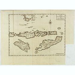
Kaart van de Zuyd-Wester Eylanden van Banda.
Early and detailed map of the Banda Islands, prepared by François Valentijn (1666–1727), a Dutch missionary who spent years in Amboina and traveled extensively through VO...
Date: Amsterdam, 1726
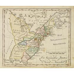
Die Vereinigten Staaten von Nord-Amerika.
Nice little German map of the early United States. The only state shown west of the Appalachian Mountains is Kentucky. Above which is a strangely shaped unnamed region (O...
Date: Augsburg, 1812
