Popular Listings

Chinese advertising poster for Red Lion cigarette brand.
This poster, an advertisement for the Red Lion Cigarettes brand from the 1930s, melds the meticulous detail of traditional Chinese painting with the craft of color lithog...
Date: Shanghai, 1950/1960

A rare suite of 12 original etchings by Martin van Maele to the famous work by Edmond Haracourt.
A rare suite of 12 original etchings by Martin van Maele to the famous work by Edmond Haracourt. The series was published anonymously in a small edition. These etchings a...
Date: Nevers, Brussels, 1882,1883

Nova Totius Terrarum Orbis Geographica ac Hydrographica Tabula.
A beautifully decorative world map taken from the 'English Atlas' by Moses Pitt and Steven Swart, based on an earlier engraved world map by Pieter van den Keere ca. 1630,...
Date: Oxford, 1680
![[Anti capitalism Soviet Union propaganda poster]](/uploads/cache/47032-250x250.jpg)
[Anti capitalism Soviet Union propaganda poster]
Propaganda mini anti-capitalism poster published in Russia during The Cold War. By the 1960’s and 1970’s, outrageous practices in Soviet bureaucracy flourished. Poor plan...
Date: Leningrad, 1974
![CH'ONHA CHIDO [Atlas of all under Heaven]](/uploads/cache/33625-250x250.jpg)
CH'ONHA CHIDO [Atlas of all under Heaven]
The Ch’onha chido [Atlas of all under Heaven] is a late 18th century copy of the traditional Korean atlas produced in the early Choson dynasty (1392-1910). One of the map...
Date: Korea, ca. 1790

Cochin (today: Ernakulam)
Small but charming 18th water color on paper depicting Cochin (today : Ernakulam) was from 1500, when the first Portuguese fleet called on its port, a firm ally of the Po...
Date: India? c.1750

Nova Totius Terrarum Orbis Geographica..
The first of four states of the map. French text on verso. One of the most beautiful world maps ever engraved and one of the most influential in promulgating the Californ...
Date: Amsterdam, 1630-1633
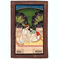
Indian painting on paper.
Fine miniature, presenting a couple in love making position, set on a balcony with in a landscape in the background. The miniature has been painted in India in late 19th ...
Date: India, ca. 1900
![[ LANDSKROON ]. Oranda Fune no zu [= Depiction of a Dutch Ship].](/uploads/cache/28003-250x250.jpg)
[ LANDSKROON ]. Oranda Fune no zu [= Depiction of a Dutch Ship].
A very large and extremely detailed Japanese drawing on rice paper of a Dutch ship at the artificial island Deshima, the VOC's outpost in Nagasaki harbour. In the drawing...
Date: Japan, Kansei 4, 2nd month, 9th day, 30 March? 1792

Nouvelle et exacte description du globe terrestre reveue corrigée et augmente´e suivant les derniéres relations des Anglais et Hollandois. Par Guillaume Blaeu 1645.
Extremely rare and decorative "carte a figures" world map published by Anthoine de Fer. The double hemisphere world map is surrounded by constellations of the A...
Date: Paris, 1645
![[Russian Agitprop propaganda poster for 9 May]](/uploads/cache/42073-250x250.jpg)
[Russian Agitprop propaganda poster for 9 May]
Soviet propaganda poster celebrating Victory Day (Thursday 9 May). Showing a star with USA, English, French flags partly overlapped with Soviet flag and inscription in Ru...
Date: Moskow, 1988

Carte générale de L'Empire Ottoman en Europe et en Asie dressée par Henri Kiepert . . .
Large School wall map of Turkish Empire printed in chromo-lithography. Published by Dieter Reimer and printed by Ferdind Barth in Berlin. This rare map has two insets in ...
Date: Berlin, Verlag von Dietrich Reimer, 1867
![.Taprobana Ins. Tabula XII Asiae. [Sri Lanka.]](/uploads/cache/27928-250x250.jpg)
.Taprobana Ins. Tabula XII Asiae. [Sri Lanka.]
1535 - PTOLEMY, C. - The mythical island of Taprobana, which originally became associated with Sri Lanka.
Date: Lyons, M. Servetus, 1535

SETTSU MEISHO ZUE. Illustrations of famous places in Settsu.
Settsu Meisho Zue was printed in two series of 8 and 4 volumes. The principal illustrator was Takehara Shunchosai, but many illustrations in the 4 volumes supplement are ...
Date: Osaka, Yanagiwara Kibei, Kansei 8-10 or 1796-1798

An embassy from the East-India Company of the United Provinces, to the Grand Tartar Cham, Emperor of China deliver'd by their excellencies, Peter de Goyer and Jacob de Keyzer, at his imperial city of Peking. . .
Very rare first English text edition of this most important and early resource on China and the Chinese. Three parts in one folio by John Macock for the author.Part I: An...
Date: London : Printed by the Author at his house in White-Friers, 1669
![Aou, Tōkei. Kokugun Zenzu [Atlas of Provinces and Counties of Japan]. (volume 1 only)](/uploads/cache/63619-250x250.jpg)
Aou, Tōkei. Kokugun Zenzu [Atlas of Provinces and Counties of Japan]. (volume 1 only)
First edition. Very attractive early Japanese Atlas of detailed maps of Japanese regions compiled by six Japanese civilians in the eighth year (1837) of the Tenpō era (1...
Date: [Nagoya]: Tōheidō, Tenpō 8 = 1837

Plan commercial de la Région Saïgon-Cholon.
Decorative publicity plan of Ho Chi Minh City, also known by its former name of Saigon and Cholon, prepared by Ngo-Trinh, surrounded by advertisements of local stores. Th...
Date: Saigon, 1948

Orbis Terrae Compendiosa Descriptio.
Gerard Mercator's great world map of 1569 was condensed into double hemispherical form by his son Rumold. It first appeared in 1587 in Casaubon's edition of Strabo's Geog...
Date: Amsterdam, 1595-1609
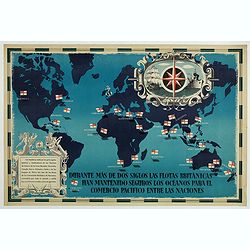
British Empire Trade Map WWII Eric Fraser.
Original vintage World War Two period British Empire trade map poster with the stylised text in Spanish reading: For more than two centuries the British fleets have kept ...
Date: England, 1941
![Venecie. [Venice] Foliu XLIIII](/uploads/cache/29716-250x250.jpg)
Venecie. [Venice] Foliu XLIIII
A very fine of Venice (192x525mm.) Verso a view of Padua. Schedel's view of Venice is one of the earliest obtainable views of the city. The view is based on the view of ...
Date: Nuremberg, 12 July 1493

LA RUSSIE ROUGE ou POLONOISE qui Comprend les PROVINCES DE LA RUSSIE ROUGE de VOLHYNIE et de PODOLIE divisées en leurs Palatinats Vulgairement Connües sous le Nom D'VKRAINE ou PAYS DES COSAQUES.
A very rare Sanson map of Ukraine and so-called Russie Rouge, stretching from Lublin in the west to Kherson Oblast in the east (here called "Confin de La Petite Tart...
Date: Paris, 1706

Mapa De la parte de la Isla Formosa sa perteneciente al Emperadotde la China sacado por Ord. De S.M.
Extremely rare map of the west coast of Taiwan, the Punghu or Pescadore Islands, and the Fokien or Fujian coast of China. Several ancient Taiwanese cities are noted, incl...
Date: Manilla, Seminario Conciliar, y Real de San Carlos, 1788-1792

Carte des Isles du Japon Esquelles est remarque la Route..
This uncommon map of Japan, on a reasonably large scale, includes commentary on the country's natural features. For instance, Ocsaqui (Okazaki, near Nagoya) is said to ha...
Date: Paris 1679
![Claudii Ptolemaei Alexandrini mathematicor[um] ...Octo libri Geographie. . .](/uploads/cache/62656-250x250.jpg)
Claudii Ptolemaei Alexandrini mathematicor[um] ...Octo libri Geographie. . .
Third edition of "Géographie" by Ptolemy and published in Strasbourg. Illustrated with 50 maps engraved in wood. One of the more important maps shows the earlie...
Date: Strasbourg, J. Grüninger, 1522
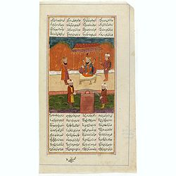
Manuscript page from a Shahnameh, The Book of Kings, written by Ferdowsi.
Page with large miniature 187 x 160mm. from the Shahnameh, or ("The Book of Kings"), which is a long epic poem written by the Persian poet Ferdowsi between c. 9...
Date: Kashmir, ca. 1830-1860

COLLECTION OF HONG KONG MAPS, BOOKS & FLYERS. Including CHINA - HONGKONG surveyed by Captn. Sir Edward Belcher, in H.M.S. Sulphur 1841. Corrected to 1901.
A collection of 30 maps, prints, and publications relating to Hong Kong. Including : - BELCHER, E. Sir, An updated version of this most important nautical chart of Hong K...
Date: London, 1841 - 1901

Americae Sive Novi Orbis, Nova Descriptio.
This is the second copperplate of Ortelius' map of the Western Hemisphere, showing the prominent bulge in the South American coastline. An important map because of its in...
Date: Antwerp, 1579

Descrittione di M. Lodovico Guicciardini patritio Fiorentino, di tutti i Paesi Bassi,...
Second Italian edition (variant B) and first Plantin edition (1st Silvius 1567) and the most sought-after edition of the famous description of the Low Countries, updated ...
Date: Antwerp, Plantin, 1581

Germania Magna (Europe continent map, folio XXVI)
1493 SCHEDEL, H. - This is the second time Iceland appears on a printed map, authored by Hieronymus Münzer. A woodcut printed map, published in 1493, in Hartmann Schedel’...
Date: Nuremberg, 1493

Nansenbushu bankoku shoka no zu.
This wall-map is a great example of Japanese world maps representing Buddhist cosmology with real-world cartography. It is the earliest one and - therefore - the prototyp...
Date: Kyoto, (Hoei 7 = Year of the Tiger) 1710
![[Anti capitalism Soviet Union propaganda poster]](/uploads/cache/47035-250x250.jpg)
[Anti capitalism Soviet Union propaganda poster]
Propaganda mini anti-capitalism poster published in Russia during The Cold War. By the 1960’s and 1970’s, outrageous practices in Soviet bureaucracy flourished. Poor plan...
Date: Leningrad, 1974
![.Tabula III Asiae. [Caucasus and Armenia.]](/uploads/cache/27894-250x250.jpg)
.Tabula III Asiae. [Caucasus and Armenia.]
Ptolemaic map of the region south of the Caucasus Mountains and between the Caspian Sea as far south as the headwaters of the Tigris River in the south and the Black Sea,...
Date: Lyons, M. Servetus, 1535
![[ Jorullo Volcano ].](/uploads/cache/27571-250x250.jpg)
[ Jorullo Volcano ].
Aquatint depicting the Jorullo Volcano engraved by Fumagalli. Plate N°61.El Jorullo is a cinder cone volcano in Michoacán, central Mexico in an area known as the Michoacá...
Date: Milan, 1827
![Etas Prima Mundi. Folium VII. [Adam and Eve, eating the apple and being expelled from paradise]](/uploads/cache/29855-250x250.jpg)
Etas Prima Mundi. Folium VII. [Adam and Eve, eating the apple and being expelled from paradise]
Latin text page with a large woodcut of Adam and Eve, eating the apple and being expelled from paradise.One of the most sought-after prints from the richest illustrated I...
Date: Nuremberg, 12 July 1493
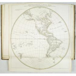
Atlas in elephant folio.
Most of D'Anville's atlases were made up for the individual customer, so no two appear alike. Many of the 59 pages are multi-sheet maps, so the actual map sheet count is ...
Date: Paris, 1771-1786

L'Art arabe d'après les monuments du Kaire depuis le VIIe siècle jusqu'à la fin du XVIIIe.
Prisse d’Avennes was one of the foremost scholars of Arabic art and architecture of the 19th century; this work represents the summation of his studies. From the aspect o...
Date: Paris, Morel, 1877

Colossus Monarchic. Statua Danielis
Fantastic double page allegorical map of a colossus figure representing the great world empires as Daniel interpreted in Nebuchadnezzar's dream. The warrior stands stolid...
Date: Augsbourg, 1730
![[Map of Palestine ]](/uploads/cache/42176-250x250.jpg)
[Map of Palestine ]
Map of Palestine from "La Mer des Hystoires" published by Dupré, Paris, 1536 "La Mer des Hystoires" is a translation into French of the famous "R...
Date: Dupre, Paris, 1536
Selling price: ????
Please login to see price!
Sold in 2025
Cruydt-Boeck van Remberus Dodonaeus. . .
Scarce, the last edition of Dodoens' Cruydt-Boeck, one of the most influential and important botanical works of the 16th and 17th centuries. With richly engraved frontisp...
Date: Leyden, 1612
![[ Traditional tools from New Caledonia ].](/uploads/cache/26366-250x250.jpg)
[ Traditional tools from New Caledonia ].
Aquatint depicting a variety of traditional tools from New Caledonia engraved by Rossi. Plate N° 72. From Giulio Ferrario's work Le Costume Ancien et Moderne ou Histoire...
Date: Milan, 1827
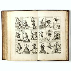
Het Groote Tafereel der Dwaasheid, vertoonende de opkomst, voortgang en ondergang der Actie, Bubbel en Windnegotie, in Vrankryk, Engeland, en de Nederlanden, gespleegt in den Jaare MDCCXX...
1720 - With 78 plates of the first banking crash, showing the shocking effects of the “South Sea Bubble” in France, England and Holland, and placing John Law with his Mis...
Date: Amsterdam, 1720
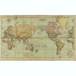
A Chart of the World on Mercator's Projection Shewing the Principal Ocean Steam Routes, the Submarine Telegraphs &c.
Charming, folding world map on Mercator's projection showing extensive steam routes and underground and undersea telegraph cables. The map is annotated in blue and red wi...
Date: London, ca. 1890

Americae Pars Magis Cognita. Chorographia nobilis & opulentae Peruanae Provinciae, atque Brasiliae, . . . MDXCII
First state. Although a map of South America it does include much of what is now the southern United States. There are two elaborate, strap-work cartouches with the one a...
Date: Frankfurt, 1592

A Map of the British Empire in AMERICA with the French, Spanish and Hollandish Settlements Adjacent Thereto. by Henry Popple. / Nouvelle Carte Particuliere de L'Amerique . . .
The four sheet Dutch edition of Popple's monumental map of North America, in mint condition. Encompassing the West Indies, Florida, Louisiana, Texas and Central America.T...
Date: Amsterdam, ca. 1737
![Tercia Etas Mundi. Folium XXX. [The flight of Egypt, Moses receiving the Commandments, God's Angel, Balaam and his talking donkey. ]](/uploads/cache/29854-250x250.jpg)
Tercia Etas Mundi. Folium XXX. [The flight of Egypt, Moses receiving the Commandments, God's Angel, Balaam and his talking donkey. ]
On recto two nice woodblock prints (each 128x222mm.) of The flight of Egypt and Moses receiving the Commandments.VERSO : a woodblock print of God's Angel, Balaam and his ...
Date: Nuremberg, 12 July 1493
![Summa philosophiae quadripartita, de rebus dialecticis, moralibus et metaphysicis . . [ With unrecorded world map ]](/uploads/cache/28639-250x250.jpg)
Summa philosophiae quadripartita, de rebus dialecticis, moralibus et metaphysicis . . [ With unrecorded world map ]
On page 107 a finely copper engraved world map (88x84mm.) Paradigma Terrae Plagas 4.ac 12. Ventorum situm indicans., centered on Europe and Africa, with parts of America,...
Date: Leiden, Peter Rigaud, 1626
![Jules Verne Le Tour du Monde en 80 jours. [Goose game board inspired by Jules Verne's novel Tour du Monde en 80 jours.]](/uploads/cache/44919-250x250.jpg)
Jules Verne Le Tour du Monde en 80 jours. [Goose game board inspired by Jules Verne's novel Tour du Monde en 80 jours.]
Goose game board inspired by Jules Verne's novel, whose boxes are illustrated with color lithographs and the center occupied by a world map. Vignette illustrations number...
Date: Paris, ca. 1880
![[ A typical Timucua Indians Village ].](/uploads/cache/27559-250x250.jpg)
[ A typical Timucua Indians Village ].
Aquatint depicting a typical Timucua Indians Village engraved by Fumagalli, after Jacques LeMoyne. The Timucua of northeast Florida (the Saturiwa and Agua Dulce tribes) a...
Date: Milan, 1827

(World map). Americus Vespucio novo te Duce Ducta Freto Ambivi Meritoqs Vocor.
Manuscript world map showing the American and African continent and the southern parts of Asia. In the Indian Ocean a large depiction of Amerigo Vespucci 1454 – 1512) on ...
Date: Italy, ca. 1954
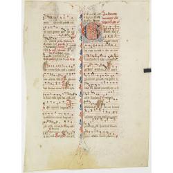
Leaf on vellum from an antiphonary.
A more than 600 years old antiphonary leaf, written in Besançon, in 1370. Musical notation on 4 bars, the staves are in red and the notes in black: numerous pen-flourishe...
Date: Besançon, 1370

Carte des côtes du Golfe du Mexique compris entre la pointe sud de la presqu'Ile de la Floride et la pointe nord de la presqu'Ile d'Yucatan:...
Detailed and important early chart of the Gulf Coast and Florida and dated 1800. First French edition of "the first printed [map] to show and name Galveston Bay&qu...
Date: Paris, 1800/1803
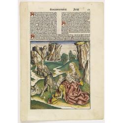
Prima Etas Mundi. IX (with Eve nursing Kain and Abel)
A very fine presentation of Eve nursing Kain and Abel. Adam is working (255x220 cm). VERSO a genealogy of Adam.Page from the richest illustrated Incunabel, the famous: Li...
Date: Nuremberg, 12 July 1493
![[Title page colored by Georg Mack Jr. to : Hortus Eystettensis, Sive Diligens et Accurata Omnium Plantarum, Florum, Stirpium,. . .]](/uploads/cache/39343-250x250.jpg)
[Title page colored by Georg Mack Jr. to : Hortus Eystettensis, Sive Diligens et Accurata Omnium Plantarum, Florum, Stirpium,. . .]
Title page to the first edition, one of about 300 copies printed, from one of the largest and most magnificent of the great flower books, depicting more than 1000 flowers...
Date: Nuremberg, ca 1613

Itinerarium Sacrae Scripturae. Das ist: Ein Reisebuch...
Itinerarium Sacrae Scripturae. Das ist: Ein Reisebuch, Uber die gantze heilige Schrifft, in zwey Bücher geteilet... Zuvor gemehret mit einem Büchlein De monetis et mensur...
Date: Magdeburg, 1587
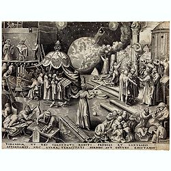
Temperance (Temperantia) from The Virtues.
Very decorative engraving by Philip Galle (Haarlem 1537–1612 Antwerp) after Pieter Bruegel the Elder (Breda (?) ca. 1525–1569 Brussels). The print was published by Hieron...
Date: Antwerp, Hieronymus Cock, 1580

Universe Europae Maritime Eiusque Navigationis Descriptio. Generale Pascaerte van Europa . . .
This general chart of north-western Europe and the surrounding coastal waters is from the rare pilot-guide De Spiegel der Zeevaerdt , printed by Christopher Plantin in Le...
Date: Leyden, 1584
![[The creation of the world - First day]](/uploads/cache/24509-250x250.jpg)
[The creation of the world - First day]
Attractive page from the Nuremberg Chronicle, showing the creation of the world: the First Day, showing the celestial choir (God\'s creation of the angels) surrounding th...
Date: Nuremberg, 12 July 1493

Mar del Zur, Hispanis Mare Pacificum.
Janssonius' fine chart of the Pacific including the west coast of America with California shown as an island, Japan and a small Australian coastline. This is the earliest...
Date: Amsterdam, 1650
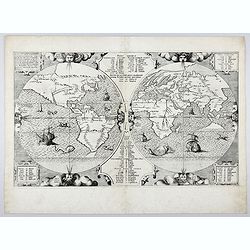
![[World and 4 continents] Carte Geographique Astronomique Chronologique et Historique du Monde.](/uploads/cache/63024-250x250.jpg)
[World and 4 continents] Carte Geographique Astronomique Chronologique et Historique du Monde.
French wall map of the world in 4 sheets published by Crépy "à l'entrée du Cloistre de St. Benoist du côté des maturins". A decorative wall map of the world sur...
Date: Paris, 1720-1735

La Florida/ Peruviae Auriferae regionis Typus/ Guastecan.
The Chaves map of Florida is a prime example of an explorer's map since it records the recent discoveries of Cabeza de Vaca, De Soto, and Moscoso. The map revealed little...
Date: Antwerp, 1592
Benedict. Arias Montanus Sacrae Geographiae Tabulam Ex Antiq
THE EXTREMELY RARE FIRST STATE landmark world map, famed for its depiction of the Australian landmass.One of the earliest printed maps to depict the “terra incognita” of...
Date: Anvers 1571 /1572
![Ch'onha chido. [Atlas of all under Heaven]](/uploads/cache/44640-250x250.jpg)
Ch'onha chido. [Atlas of all under Heaven]
A late 18th-century Ch'onha chido atlas with 10 woodblock maps showing the World, China, and the 8 province maps of Korea (Hamgyeong, Gangwon, Jeolla, Gyeongsang, Pyeonga...
Date: Korea, ca. 1780

La mer Mediterranee divisee en ses principales parties ou mers. . .
Very large map centered on the Mediterranean. With a sub title along upper margin "La Mer Mediterranée divisée en Mer de Levant et de Ponant Subdivisées en Leurs Pri...
Date: Amsterdam, c.1705
![[Europe, Eastern, Sarmatia, Ukraine]](/uploads/cache/33854-250x250.jpg)
[Europe, Eastern, Sarmatia, Ukraine]
Wood block printed map and one of the earliest printed representations of European Sarmatia, generally the region between the Baltic and Black Sea and Sea of Azov. Includ...
Date: Vienna, Trechsel, G., 1525 -1541

Il Cuscho citta principale della provincia del Peru.
A very desirable and scarce item of this decorative and early bird's-eye town-plan of the Inca city of Cuzco. Several figures shown inside the city walls and on the hills...
Date: Lyons, 1564
![Anverpia, nobile in Barbantia oppidum, parrim maritimum . . . [Antwerp]](/uploads/cache/26518-250x250.jpg)
Anverpia, nobile in Barbantia oppidum, parrim maritimum . . . [Antwerp]
The bird's-eye plan provides an excellent view of the citadel, city, docks and fortifications. The city was defended by a line of fortification and a moat constructed und...
Date: Cologne, 1585

Amstelodamum, Celebre Emporium Forma Plana.
Second state of this rare and decorative plan of Amsterdam with Visscher's imprint. With a panoramic view seen from the IJ and further insets of Council House, The Exchan...
Date: Amsterdam, c. 1636

Nova Orbis Tabula in Lucem edita A.F.de Wit.
According to Shirley, De Wit's map is one of the most attractive of its time. The brilliant scenes in the corners combine images of the four seasons, the elements, and th...
Date: Amsterdam, 1680
![(Chatelain "Atlas Historique" in 7 volumes.]](/uploads/cache/47053X-250x250.jpg)
(Chatelain "Atlas Historique" in 7 volumes.]
Henri Abraham Chatelain, whose Atlas Historique was one of the most expansive encyclopedias of the age. First published in 1705, Chatelain's Atlas Historique was part o...
Date: Amsterdam: Chez Zacharie Châtelain, 1732 - 1739
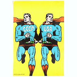
CCCP/USA, 1966
Original 1968 Cold War Superman Style Poster by Roman Cieslewicz (1930-1996). Published by Georges Fall, Paris. Printed by Serg, Paris.In 1968 the Parisian left-wing art...
Date: Serg, Paris, 1968

Manuscript atlas.
Charming manuscript atlas with 6 maps, pen and ink and water color, showing France, Europe, Africa, Palestine, North America and South America.The atlas is done by a youn...
Date: France, 1835
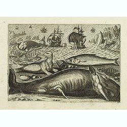
Virulus marinus. Cete (Whale and whaling scene)
Whale and whaling scene, set against a mountainous landscape in the manner of Pieter Brueghel the Elder. Plate number 1. The engraving is copied after Adrian Collaert pla...
Date: Antwerp, after 1598

Pianta Geografia delle Isole di Malta, e Gozo della Sagra Religione Gerosolimitana di S. Giovanni delineata, ed incisa in quest anno 1761.
A rare map of Malta and Gozo printed by the priest Antonio Bova (1688 - 1775), who was active as engraver in Palermo ca. 1727-1773. He produced cartographic engravings, s...
Date: Bova Ant., Palermo, 1761

Atlas des Missions de la Société des Missions-Étrangères. . .
This scarce atlas contains maps showing the locations of the Catholic missions belonging to the Société des Missions Étrangères in Asia. It covers India, Burma, Siam, Mal...
Date: Lille, 1890
![Ulma Folio CXCI [With view of Ulm.]](/uploads/cache/29713-250x250.jpg)
Ulma Folio CXCI [With view of Ulm.]
Double-page panoramic view of Ulm.An imaginary view, however, is the earliest obtainable view of this period.Two pages from the richest illustrated Incunabel, the famous ...
Date: Nuremberg, 12 July 1493

AIR France - Le plus grand réseau du monde.
Created in 1959 by the artist Lucien Boucher, showing all of the DC-7 Air France Routes. The Blue Pink Poster is one of a series of eight posters commissioned by Air Fran...
Date: Imprimerie Perceval, Paris, 1959

Mercurius.
Mercury holding a caduceus and riding in a chariot drawn by two birds on the clouds in the sky, an extensive landscape with a harbor with goods being loaded and unloaded ...
Date: Antwerp, 1585
Selling price: ????
Please login to see price!
Sold in 2025

Frisia occidentalis.
A rare separately published carte-a-figures of Friesland by Geelkercken in its first state. The title and the coats of arms of the eleven Frisian towns appear in the cent...
Date: [Leeuwarden], Dierick Albertsen, 1618

Tabula Superioris Indiae & Tartariae maioris. (Modern Map of China, Japan, etc.)
Important map extending from Tartary in the north, to "Prov. Bocat" (Cambodia) in the south. "Tebet" is shown prominently, as is "Zinpangri"...
Date: Vienne, 1541

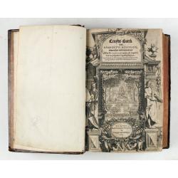
Nieuw Nederlandtsch Caertboeck. Waer in volkomentlijcker als oyt te voren vertoont werden de XVII. Nederlanden.
Rare first edition of this atlas of the provinces of the Netherlands, Belgium and Luxemburg. Engraved title page, with : "Gedruckt t' Amsterdam by Abraham Goos Plaet...
Date: Amsterdam, 1616
