Popular Listings

FN HJAELP (Help).
Danish poster depicting a child sitting on a globe, threatened by a black snake. Designed by Aage Sikker Hansen and printed Andreasen & Lachmann in Copenhagen, Denmar...
Date: Copenhagen, ca. 1950

Parte orientale della China.. / Parte occidentale della China. (2 sheets)
The map depicts the eastern part of China with Korea -correctly- as a peninsula. Formosa is included as well. Japan is partly visible i.e. the area of Yamaguchi, strait K...
Date: Venice, 1695

Lion and Bull made of terracotta.
Very fine terracotta figure of a lion symbolizing the continent of Africa. The Bull symbolizing Europe.The items will be dispatched in 4 wooden crates from Belgium. Pleas...
Date: Netherlandisch , 1780~1800
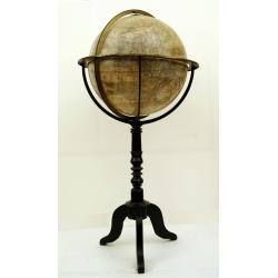
Globe terrestre d'après les découvertes..
Attractive and large (height 112cm) library globe by a prominent Paris globe maker, with a brass meridian circle, horizon ring, and hour ring, supported by four brass qua...
Date: Paris, ca. 1885

Novissima et Accuratissima Totius Americae Descriptio.
Second state of Visscher's map of the Americas, this decorative map greatly influenced the cartography of the Americas both geographically and artistically.Although it di...
Date: Amsterdam, 1677

Over deese grietenije.. Eerste van Wester Goo..
Very decorative map centered on Menaam, Marsum and Boxum from the Uitbeelding der Heerlijkheit Friesland prepared by Schotanus. With ornamental title cartouche lower righ...
Date: Leeuwarden, F.Halma, 1718

New Jersey entworfen von D.F. Sotzmann. Hamburg bey Carl Ernst Bohn 1796 . . . NO.VIII
Extremely rare map of New Hampshire prepared by Daniel Friedrich Sotzmann for Christopher Ebeling's "Erdbeschreibung von Amerika", a project ended after only te...
Date: Hamburg, Carl Ernst Bohn, 1797

La Pieuvre Germanique.
Scarce lithographed plate not dated, by Eugène Danzanvilliers, printed by Grandremy in Paris. The plate listed by Adhemar is dated 1874. Eugène Danzanvilliers was a draug...
Date: Paris, 28 Quai de la Rapée, c.1874

Terra Promissions.
A beautifully executed and very rare map of the Promised Land, divided into the 12 Tribes. The shore line runs in north-southwesterly direction from Sidon as far as Pelus...
Date: Paris, c.1655

Vue et description des principales villes de l'Armenie et de la Georgie avec les habillements des femmes du pays, et ceux des prêtres et religieux armeniens. . .Tom: V N° 11 Pag: 28
View and description of the principal Armenian and Georgian cities with illustrations of Armenian women's garments as well as priests' and monks' clothing. The views are ...
Date: Amsterdam, ca 1720
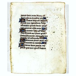
Leaf on vellum from a manuscript Book of Hours.
14 Lines of text in Latin and three 1-line initials in blue on colored grounds.RECTO: 14 Lines of text in Latin and four 1-line initials in blue on colored grounds with l...
Date: France, ca.1470
Selling price: ????
Please login to see price!
Sold in 2025

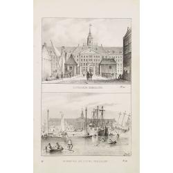
A Perspective View of the Admiralty Office, Dock-Yard, Storehouses &c. at Amsterdam.
Decorative engraving giving good detail of the intense activity in the Amsterdam dockyards.Engraved for BANKES's New System of Geography
Date: Amsterdam, 1780
![[Title in Russian; translated to : Who the death bears, that's himself in the end I'm sure I'll stretch my legs. (Google translation) ]](/uploads/cache/41506-250x250.jpg)
[Title in Russian; translated to : Who the death bears, that's himself in the end I'm sure I'll stretch my legs. (Google translation) ]
Propaganda mini poster published in Russia during The Cold War (1979–1985). The time refers to the phase of a deterioration in relations between the Soviet Union and the ...
Date: Russia, 1982
![[ Montezuma II As Represented in an Anonymous Codex in The Vatican ].](/uploads/cache/27574-250x250.jpg)
[ Montezuma II As Represented in an Anonymous Codex in The Vatican ].
Aquatint depicting Motezuma II represented in the Vatican's anonymous codex engraved by DKB. Plate N°64.The Codex Vaticanus, so called because it is the most famous manus...
Date: Milan, 1827

Citta, porto, e rada di Brest, e . . . Nella Bretagna . . .
A beautiful and rare map of Bretagne. In top right an inset with the town of Brest.The remarkable Vincenzo Coronelli (1650-1718), encyclopaedist, geographer, inventor and...
Date: Venice, 1690

The Rubaiyat of Omar Khayyam (Edward Fitzgerald translation)
Edward FitzGerald, an outstanding writer who has done more than anyone to popularise English poetry. His best-known work, The Rubaiyat of Omar Khayyam (1859), began by be...
Date: England, ca. 1930

La Chine d'Athanase Kirchere de la compagnie de Jesus, illustrée de plusieurs monuments tant sacrés que profanes et de quantité de recherches de la nature. . .
Athanasius Kircher, S.J., (1601 or 1602-1680) was a 17th-century German Jesuit scholar who published around 40 works, most notably in the fields of oriental studies, geol...
Date: Amsterdam, 1670

Imperii Russici et Tartariae Universae tabula novissima.
Decorative and rare map covering Russia, Tibet, China, Tartary, Korea, Taiwan and Japan prepared by J. M. Hasius. The sea between Japan and Korea is mentioned Mare Orient...
Date: Utrecht, 1743

Chorographia Terrae Sanctae in Angustiorem. . .
Rare. Large visually rich map decorated with illustrations of the sacred objects and places of Judaism. In the bottom center is a plan of ancient Jerusalem, and the route...
Date: Amsterdam, ca. 1700
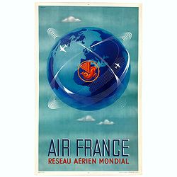
Réseau aérien mondial.
"Sur les ailes d'Air France, découvrez le monde à votre tour" lithograph poster from AIR France. A great mid-century design by Air France advertising poster by ...
Date: Imprimerie Perceval Paris, ca. 1940-1950

Arabia.
A handsome map of the Arabian Peninsula drawn on a large scale on which the three classical divisions are shown with some urban centers and topographical features. A cert...
Date: Amsterdam, 1662

Partie de la Chine N°86. (Covers Guizhou and parts of Yunnan, Guangxi, Hunan, Hubei and Sichuan.)
Covers Guizhou and parts of Yunnan, Guangxi, Hunan, Hubei and Sichuan.From his famous Atlas Universel . This atlas was one of the most remarkable world atlases ever produ...
Date: Brussels, 1825-1827
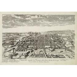
Turin ville capitale du Piémont, et Résidence du Duc de Savoye. . .
A very decorative and rareof Turin, including a numbered key (A-M) in lower part. Engraved by Pierre-Alexandre Aveline. With "fait par Aveline avec privilege du Roy ...
Date: Paris, ca.1692

Corea and Japan.
A fine large-scale map of Japan and Korea showing an increasingly refined outline to the Japanese islands but still oversized Korean peninsula. The strait south of Korea,...
Date: Edinburgh, 1816

United States At-A-Glance.
A clever device for demonstrating the statistics of each state, the Area, Population, Highest Elevation, Principal River, Capital, railroad Mileage, Date Entered Union, P...
Date: New York / London: International At-A-Glance Chart Co. 1931

Tabula Americae Specialis Geographica Regni Peru, Brasiliae, Terra Firmae & Reg: Amazonum, Secundum relationes de Herrera, de Laet & PP d Acuña & M. Rodriguez . . .
A good and clean copy of Homann's map of the northern part of South America. The map is on the Valley of the Amazon and delineates the Amazon and its labyrinth of tributa...
Date: Nuremberg, 1728

North and South America At-A-Glance.
A clever device for demonstrating the statistics of each country, the Area, Population, Population per Sq. Mile, Highest Elevation, Principal River, Currency, Capital, Fo...
Date: New York & London: International At-A-Glance Chart Co. 1931
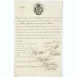
Very rare share in the Ostend Company. (299)
Upper left hand corner share number "299" in manuscript. In top emblem of the Company in copper engraving. Text: " De Directeurs van de generale Keijserlij...
Date: Antwerp / Ostend, 1723
![Art arabe. - [No tittle]](/uploads/cache/32750-250x250.jpg)
Art arabe. - [No tittle]
Lithographed by Daumont. From the author's "L'Art Arabe d'après les monuments du Kaire...". Emile Prisse d'Avennes, Orientalist and Muslim convert, obsessive in...
Date: Paris, 1877
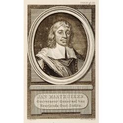
Portrait of Jan Maatzuiker.
Portrait of Jan Maatzuiker, Governor-General of the East Indies from 1653 till 1678. From Kok's Woordenboek . Engraved by Reinier Vinkees in 1790.
Date: Amsterdam, 1790

Rhode Island entworfen von D.F. Sotzmann. Hamburg bey Carl Ernst Bohn 1798 . . . NO.V
Extremely rare map of Rhode Island prepared by Daniel Friedrich Sotzmann for Christopher Ebeling's "Erdbeschreibung von Amerika", a project ended after only ten...
Date: Hamburg, Carl Ernst Bohn, 1797

Die Zyp / La Zype.
A miniature map showing the polder of De Zype. Title cartouche in the upper side.First published in 1598 in his Caert-Thresoor, the plates were executed by the most famou...
Date: Amsterdam / Frankfurt, 1609

III. Carte de la Hollande.. Over-Yssel.
Attractive small map centered on the delta of the River Ijssel, where it discharges into the Zuiderzee.From Atlas Portatif Universel, by Robert de Vaugondy. Unrecorded st...
Date: Paris, later than 1748

Mer de Chine - Detroit De Singapour Partie Comprise Entre Singaour et Le Dett. De Malacca d'apres les travaux du Commr. J.W. Reed de la Marine Royale d'Angleterr, ...
A detailed chart of Singapore Strait, drawn from an English Chart by J.W. Reed, who surveyed Singapore and environs between 1865 and 1869, aboard the H.M.S. Rifleman.The ...
Date: Paris, 1873
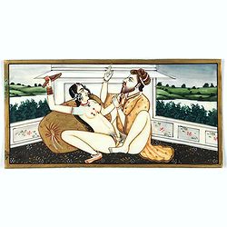
Indian painting on ivory
Fine oriental miniature of a amorous scene of an Indian couple with a landscape in the back. Drawing, brush and gouache on ivory panel, late 19th/ early 20th cent.
Date: Iran, India, ca. 1900

Carte des Iles Hawaii.
A lovely small map of the complete chain of Pacific islands known today as the Hawaiian islands, from Dumont d'Urville's atlas "Voyage pittoresque autour du Monde.&q...
Date: Paris, 1834

Carinthiae et Goritiae... / Histria tabula.../ Zarae, et Serebenici ..
Three maps on one sheet. The left hand is centered on the eastern part of Austria. The right upper hand map is centered on northern Yugoslavia, and the last map is center...
Date: Antwerp, 1598

Cajanie, ou Bothnie Orientale Tirée de celles d'Andr Burae et de Isaac Massa. . .
Map of the Northern part of Gulf of Bothnia, today's border area between Sweden and Finland. The map derive from the work of the Swedish cartographer Andreas Bureus and I...
Date: Paris, P.Mariette, 1666

Imperii Sinarum nova descriptio.
Schenk and Valk's rare early 18th century issue of Janssonius milestone map of China, Korea and Japan after Martino Martini. Engraved by Johannes van Loon. The overall ba...
Date: Amsterdam, ca. 1720

Carte des Isles de Maiorque Minorque et Yvice dediée A.M. le Comte de Maurepas Ministre et secretaire d'Etat. . .
Fine map of the Baleares with much detail, in lower part inset "Plan du Port de Mahon du Fort St. Philippe et ses Fortifications". The map is dedicated to Jean ...
Date: Amsterdam, after 1740

Le cours entier du grand et Fameux Nil. . .
Scarce. A splendid map of ancient Egypt. West is at the top and the Nile bisects Egypt. A inset shows modern Egypt to good detail. With the Red Sea and part of the Arabia...
Date: Augsburg, 1760
Funeral in China.
A scene of a funeral in China from Linschoten's famous voyages to the East of 1583-92, here published by De Bry the year after they first appeared as a separate book. Fro...
Date: Frankfurt, 1599
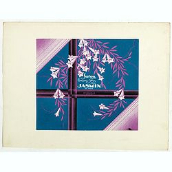
Art déco label for de Neuville, Paris.
Lithographed perfume label " Savon extra fin au jasmin N°1727 " laid on original cardboard sheet. A striking example of commercial artworks produced by the arti...
Date: Paris, between 1925 and 1930

Norimberga.
A spectacular panoramic town-view of Nuremberg, with legends numbered from 1-39 in German. With the title in a banderol.After a design by Friedrich Bernhard Werner (1690...
Date: Augsburg, ca. 1720
![Flandra parte occidentale: dedicata all'illustrissimo et eccelententissimo S. Giorgio Cocco, senatore meritissimo. . . [together with] Zelanda e Parte Orientale della Flandra. . . .](/uploads/cache/31286-250x250.jpg)
Flandra parte occidentale: dedicata all'illustrissimo et eccelententissimo S. Giorgio Cocco, senatore meritissimo. . . [together with] Zelanda e Parte Orientale della Flandra. . . .
Wall sized map of two joined sheets of Flanders, the coastline running from Calais to Zeeland in the Netherlands. Including major cities along the coast such as Dunkerque...
Date: Venice, 1696
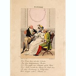
Zerstreuung.
Engraved by Joseph Stöber, (born in Vienna 13. June 1768, died 12 March 1852) after design of Matthäus Loder (1781-1828). From Castelli, "Zerrbilder menschlicher Tor...
Date: Wien, 1818
![.[Georgia (Republic), Sarmatia, Ukraine]](/uploads/cache/33870-250x250.jpg)
.[Georgia (Republic), Sarmatia, Ukraine]
Wood block printed map and one of earliest printed representation of Georgia (Republic), Sarmatia, Ukraine prepared by Martin Waldseemüller. Based on the slightly larger ...
Date: Vienna, Trechsel, G., 1525 -1541
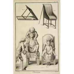
Chirurgie, plate XII
Showing a medical chair and a physician at work from the medical section of Diderot's Encyclopédie. Engraved by Bernard after a design of Goussier. Very important work as...
Date: Paris 1779

Madrid.
Extremely rare town-view of Madrid. Engraved by Francesco Ambrosi.With a second title in lower part "Madrid Ciudad Capital Del Reyno D'Espana y real corte de los rey...
Date: Bassano del Grappa, c.1780

Carte qui contient..Iles & Terres..L'Amerique..Jamaique..
Eight maps on one sheet. From Chatelain's Atlas Historique et Méthodique . Including maps of Bermuda, Jamaica, New England with Long Island, Carolina, Chesapeake and Dela...
Date: Amsterdam 1728

La Basilica Vaticana consacrata al Principe de gli Apostoli . . .
Monumental engraving showing the Papal Basilica of St. Peter in the Vatican, in its setting, with below a coat of arms with dedication to Cardinal Sigismondo Chigi. Obili...
Date: Rome, 1693
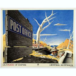
Outposts of Empire. Central Australia.
A large colored lithograph by John Vickery (1906-1983), he was an Australian artist. He worked in the fields of painting, illustration and advertising. He is the only Aus...
Date: London, ca 1937
![Schat-Kamer ofte konst der stuurlieden, inhoudende Een duidelyke onderwyzinge in de navigatie. . . [bound with] Geographische Tadfel vande Graaden.. Voornaamste Zee-haavens. . .](/uploads/cache/33114-250x250.jpg)
Schat-Kamer ofte konst der stuurlieden, inhoudende Een duidelyke onderwyzinge in de navigatie. . . [bound with] Geographische Tadfel vande Graaden.. Voornaamste Zee-haavens. . .
Rare and important manual originally prepared by Klaas de Vries and improved by Evert Floryn and S.Hollander of the "Schat-Kamer ofte konst der stuurlieden" (Tr...
Date: Amsterdam, Wed. Gerard Hulst van Keulen, 1802

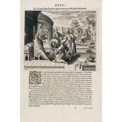
Quella Tavola E l'Antica Siria ch'Era destinta in dodici . . .
Very rare view of Holy Land published in the first edition of "Viaggio da Venetia, a Costantinopoli. Per Mare, e per Terra, & infieme quello di Terra Santa. Da G...
Date: Venice, Giacomo Franco, 1598
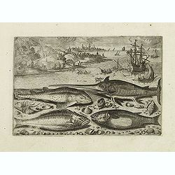
Gladius piscis, Galeus piscis, Araneus, Mugil. (Piscium Vivæ Icones - Fish)
Depiction of Gladius piscis, Galeus piscis, Araneus, Mugil. Fish set against a mountainous landscape in the manner of Pieter Brueghel the Elder. Plate number 15. The engr...
Date: Antwerp, after 1598
![Vue de la Rivière d'Endeavour sur la Côte de la Nouvelle Hollande ou le Vaisseau fut mis à la bande. [Tome IV Pl. 1ère.]](/uploads/cache/26093-250x250.jpg)
Vue de la Rivière d'Endeavour sur la Côte de la Nouvelle Hollande ou le Vaisseau fut mis à la bande. [Tome IV Pl. 1ère.]
The first known landscape drawing of the east coast of Australia. A View of the Endeavour River, on the coast of New Holland, where the ship was laid on shore, in order t...
Date: Paris, 1773

VI. Partie du Duche de Gueldre où se trouve la Veluwe.
Attractive small map covering the northwestern part of Gelderland. In the center "'t Loo". From Atlas Portatif Universel, by Robert de Vaugondy.Unrecorded state...
Date: Paris, later than 1748
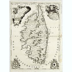
Isola di Corsica, Dedicata all' Em;mo e Rmo: Principe, il Sr. Cardinale Carpegna, Vicario di Sua Santita. . .
One of the most decorative maps of Corsica, with in the upper right, a draped fabric that bears the map's scales is dressed with two angels, one holding the cross, a coat...
Date: Venise, 1692
![Hong Kong. [Queen's Road]](/uploads/cache/24362-250x250.jpg)
Hong Kong. [Queen's Road]
Finely executed watercolor made by Henri Dieth of a charming atmospheric street scene at Queen's Road in Hong Kong. The watercolor is made after Eduard Hildebrandt (1818-...
Date: Germany, 1882

Carte des Principales Ports de Mer Bancs de sable &c: qui sont dans la Mer Rouge..
Some cities existed along the western coast of the Arabian peninsula, where they served as entrepots for transcontinental trade between Europe and Asia. Mecca, founded by...
Date: Amsterdam, 1720
![[ Local Mexican Indian game, the Voladores de Papantla ].](/uploads/cache/27587-250x250.jpg)
[ Local Mexican Indian game, the Voladores de Papantla ].
Aquatint depicting local game engraved by Fumagalli. Plate N°77.The Aztecs also had spectacular dances such as the Voladores de Papantla ,the Sun Dance, in which the danc...
Date: Milan, 1827
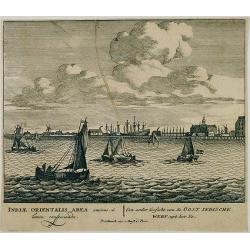
Een ander gesicht van de Oost Indische Werf: uyt het Ye.
Decorative engraving giving good detail of the entrance of the IJ with in the background the ship building wharf of the V.O.C. and its ware house, presently the Maritime ...
Date: Amsterdam, 1670

(The City And Harbour Of Sydney From Near Vaucluse.)
One of the most sought after views of the city and harbour of Sydney seen from Near Vaucluse, 1852. Magnificent hand-colored tinted lithograph and finished by gum-Arabic....
Date: London, J. Hogarth, 1852
![[Printed on silk] Nova Totius Americae Sive Novi Orbis Tabula, Auct. Hugo Allardt.](/uploads/cache/48420-250x250.jpg)
[Printed on silk] Nova Totius Americae Sive Novi Orbis Tabula, Auct. Hugo Allardt.
Hugo Allard’s ca. 1661 map of the Americas, showing California as an island printed on silk. This separately issued map printed on paper is quite rare on the market. The...
Date: Amsterdam, 1661
![Sincapour. [Singapore]](/uploads/cache/23696-250x250.jpg)
Sincapour. [Singapore]
Early view of Singapore after Pâris, engraved in aquatint by Sigismond Himely (1801-1872). The view is drawn looking up the Singapore River from South Boat Quay. It show...
Date: Paris, Finot, 1835

CANTON Kong-Teheou.
Very detailed (1:1.000.000) map centered on Macao and Victoria Island, showing soundings, English, Australian, Danish telegraph lines reaching Hong Kong and extended to M...
Date: Paris, 1898 updated for june 1904
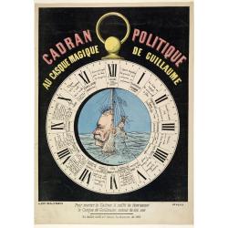
Cadran Politique au casque magique de guillaume.
A rare broad sheet about the Franco-Prussian War. Showing a large clock with in the center William I, the German Emperor, surrounded by 12 stages of the war.Printed by Gi...
Date: Paris, c.1872

Hongarije.
Poster made for Hungarian Tourist association. The uncommon Dutch version of this fine poster to promote Hungary in the 1930's. Arisztid Uher was a graphic designer. He d...
Date: Budapest, KLOSZ / Sohn., ca. 1930

Biturigum.
A miniature map of the Berry. Fine cartouche in the upper left corner.First published in 1598 in his Caert-Thresoor, the plates were executed by the most famous engravers...
Date: Amsterdam/Frankfurt 1609
Oostindische Zeemagazijn. & De Werf van Het Oostind. Zeemagazijn.
Two decorative lithographies on one sheet, illustrating the V.O.C. East Indian Arsenal and the naval shipyard.
Date: Amsterdam, ca. 1840

Quinta Asie Tabvla.
A woodblock map of ancient Median and Persian lands in modern-day Iran is from Martin Waldseemüller's 1513 edition of Ptolemy, a landmark work that contributed to major a...
Date: Strasbourg, J. Schott, 1513
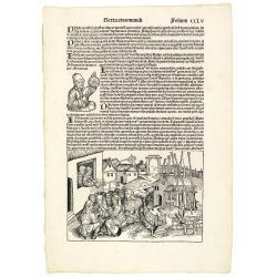
Sexta Etas Mudi. Folio CCLV. (With portret of Johannes Müller alias Regiomontanus holding a Astrolabe.
A very fine presentation of the astronomer Johannes Müller alias Regiomontanus holding a Astrolabe. A village-scene (Dim. H : 150 mm W : 223 mm) is depicted on the lower ...
Date: Nuremberg, 12 July 1493

Vue du Magazin de la Compagnie des Indes Orientales. . .
So-called optical print of the formerly the V.O.C. warehouse and arsenal for the Admiralty of Amsterdam, now-a-days the Scheepvaartmuseum (Maritime Museum).In the eightee...
Date: France, 1780

Coloniensis Archiepisscopatus.
Extremely rare first edition of this beautiful map of Cologne and Dusseldorff.Jodocus Hondius Jr. planned to produce a new modern atlas less dependent on the Mercator pla...
Date: Amsterdam, 1629

Florentini Dominii Fidelissima et nova descriptio.
The map is centered on the city of Florence and extends to Liguria, the Apennine Mountains, the Adriatic Coast, Siena and Lago di Perugia. The map is based upon Stefano B...
Date: Anvers, 1598

Designs for porcelain vases with Chinese motif.
Hand colored design of 13 vases with attractive patterns of a classic Chinese motif. In right "Planche d'aquarelle N° 04004" and the numbers 7.404, 2.074, 8.930...
Date: Desvres, 1905 - 1925

U.R.S.S. Energie Eléctrique. (5)
Map of Russia. Publicity poster for Russia's electrical production. Text in French. Editions de l'Agence de presse Novosti".More about War Maps & Propaganda maps...
Date: USSR, 1978
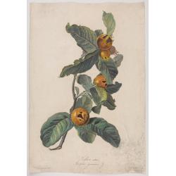
Neflier cultivé. Mespilus germanica. L.
A bouquet of flowers. Engraved by P.F. Le Grand after designs by the Dutch born Gerard van Spaendonck (1746-1822).Taken from the rare work "http://www.swaen.com/Fleu...
Date: Paris, ca.1800

Nieuwe Kaart van het Eyland Sumatra..
Fine chart depicting the Island of Sumatra and the southern coasts of Malaysia from Quedo to Johore. North is orientated to the left of the page. Singapore is probably id...
Date: Amsterdam, 1726
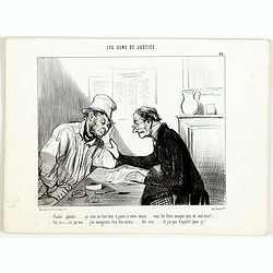
Les Gens de Justice. - Plaidez, plaidez . . . ça sera un bon tour à jouer à votre voisin. . .
Second state (of 2), with text. From "Les Gens de Justice". Text below image : - Plaidez, plaidez . . . ça sera un bon tour à jouer à votre voisin . . . vous lu...
Date: Paris, 1845-1848
