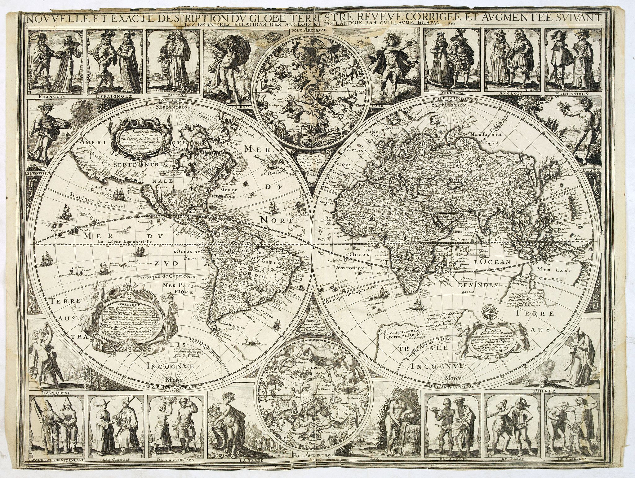
Nouvelle et exacte description du globe terrestre reveue corrigée et augmente´e suivant les derniéres relations des Anglais et Hollandois. Par Guillaume Blaeu 1645. |
||||||||||||||||||||
|
||||||||||||||||||||
|
|
||||||||||||||||||||
$25000 / ≈ €21971This item is available for immediate sale! Questions before Buying ?
We are happy to answer your questions. |
My Collection +
Add this or any of your favorite items in one place. If you want to save the items permanently, you have to sign in or create an account first. |
|||||||||||||||||||
Description
Extremely rare and decorative "carte a figures" world map published by Anthoine de Fer. The double hemisphere world map is surrounded by constellations of the Arctic and Antarctic poles. The upper and lower ornamental borders show peoples of the world and allegorical figures of the four elements. Side borders show allegorical figures of the four seasons. Ships and sea creatures in bodies of water. Includes exploration notes for America, Australia and other regions. Some notes in decorative cartouches.
The map has been engraved by Henri le Roy, with his signature below the western hemisphere.
Antoine de Fer copied the map after Claes Jansz. Vischers world map of 1638. His map has a French title and inscriptions. Antoine de Fer translated the cartouche placed below North America which describes America as first discovered by Christopher Columbus in 1592 and subsequently by Amerigo Vespucci in 1599. He adds the circumnavigations of Admiral Jacob L’Hermite (1625) - expedition to establish a southern route to the Dutch East Indies around Cape Horn, to investigate establishment of a Dutch colony on the west coast of South America, to attack Spanish merchant shipping, and to plunder Spanish gold and riches. He also ads Hendrik Brouwer (1643) - While rounding Cape Horn, the expedition established that Staten Island was not part of the unknown Southern land.
The partial outline of Australia may well have been derived from Blaeu whose firm was in the possession of revised information by the mid 1640's.
California has also been amended so that it appears as an island. Interestingly he ads "Californie Isle long 1700 lieus". Also Anthoine de Fer ads borders in North America clearly dividing "Nouvelle Bretaigne", "Nouvelle France", "Nou. Belgium", "Floride", "Virginie", "Granade", "Hispania"," Canifornia Is" and "Nouvelle Angleterre" is placed in the Ocean. Borders are also added for South America and the other continents.
Surprisingly Anthoine the fair depicts Korea on his map as an island "Coree Is".
In general the cartography is very up-to-date for the period, showing the discovery of Hudson's Bay and the course of the St. Lawrence river. The Straits of le Maire and Magellan are shown. Beach is still shown in the region that would become Australia, based upon the reports of Marco Polo. The early Dutch discoveries in what would become northern Australia are shown.
The cartouche next to "Australia" bears the address "A Paris chez Chez Anthoine de Fer Merchant detailles, doulces Enlumineur des Cartes Geographiques, Demeurant en L'Isle du Pallais, sur le Quay qui regarde le megisserie, proche le pont au Change, a l'ange de Fer 1645".
Although Antoine de Fer copied greatly from Visscher's map, he enlisted Willem Blaeu in the title. According to Tooley, presumably, because the name of Visscher did not carry sufficient international status. As a matter of fact Blaeu's map where largely available in Paris at this time, which could not be said for Claes Jansz. Visscher his maps. As a matter of fact the figured border maps for which C.J.Visscher was renowned seems to be a typical Dutch product not used in France. The map is there for one of the first on few examples of such a map produced in France.
The output of Antoine de Fer is very small. The title states the name of Blaeu.

Reference: Shirley, World, 364.
FAQ - Guarantee - Shipping
Buying in the BuyNow Gallery
This item is available for immediate purchase when a "Add to Cart" or "Inquire Now" button is shown.
Items are sold in the EU margin scheme
Payments are accepted in Euros or US Dollars.
Authenticity Guarantee
 We provide professional descriptions, condition report (based on 45 years experience in the map business)
Paulus Swaen warrants the authenticity of our items and a certificate of authenticity is provided for each acquired lot.
Condition and Coloring
We indicate the condition of each item and use our unnique HiBCoR grading system in which four key items determine a map's value: Historical Importance, Beauty, Condition/Coloring and Rarity.
Color Key
We offer many maps in their original black and white condition. We do not systematically color-up maps to make them more sellable to the general public or buyer.
Copper engraved or wood block maps are always hand colored. Maps were initially colored for aesthetic reasons and to improve readability. Nowadays, it is becoming a challenge to find maps in their original colors and are therefor more valuable.
We use the following color keys in our catalog:
Original colors; mean that the colors have been applied around the time the map was issued.
Original o/l colors; means the map has only the borders colored at the time of publication.
Colored; If the colors are applied recently or at the end of the 20th century.
Read more about coloring of maps [+]
Shipping fee
A flat shipping fee of $ 30 is added to each shipment by DHL within Europe and North America. This covers : International Priority shipping, Packing and Insurance (up to the invoice amount).
Shipments to Asia are $ 40 and rest of the world $50
We charge only one shipping fee when you have been successful on multiple items or when you want to combine gallery and auction purchases.
Read more about invoicing and shipping
FAQ
Please have a look for more information about buying in the BuyNow gallery
Many answers are likely to find in the general help section.
My Collection+
![]()
With My Collection+ you can collect all your favorite items in one place. It is free, and anyone can create his or her virtual collection.
Unless you are logged in, the item is only saved for this session. You have to be registed and logged-in if you want to save this item permanently to My Collection+.
Read More[+]
Register here, it is free and you do not need a credit card.
Add this item to
My Collection+
or click the following link to see My Collection+.
| Digital Image Download | |
|
Paulus Swaen maintains an archive of most of our high-resolution rare maps, prints, posters and medieval manuscript scans. We make them freely available for download and study. Read more about free image download |
Click the image for a free small image download. |
In accordance with the EU Consumer Rights Directive and habitually reside in the European Union you have the right to cancel the contract for the purchase of a lot, without giving any reason.
The cancellation period will expire 14 calendar days from the day after the date on which you or a third party (other than the carrier and indicated by you) acquires, physical possession of the lot. To exercise the right to cancel you must inform Paulus Swaen Inc, of your decision to cancel this contract by a clear statement (e.g. a letter sent by post, or e-mail.
To meet the cancellation deadline, it is sufficient for you to send your communication concerning your exercise of the right to cancel before the cancellation period has expired.
