Sign In or Sign Up
Benedict. Arias Montanus Sacrae Geographiae Tabulam Ex Antiq |
||||||||||||||||||||
|
||||||||||||||||||||
|
|
||||||||||||||||||||
$21500 / ≈ €18797This item is available for immediate sale! Questions before Buying ?
We are happy to answer your questions.
21500.00
|
My Collection +
Add this or any of your favorite items in one place. If you want to save the items permanently, you have to sign in or create an account first.
Watchers:
7
|
|||||||||||||||||||
Description
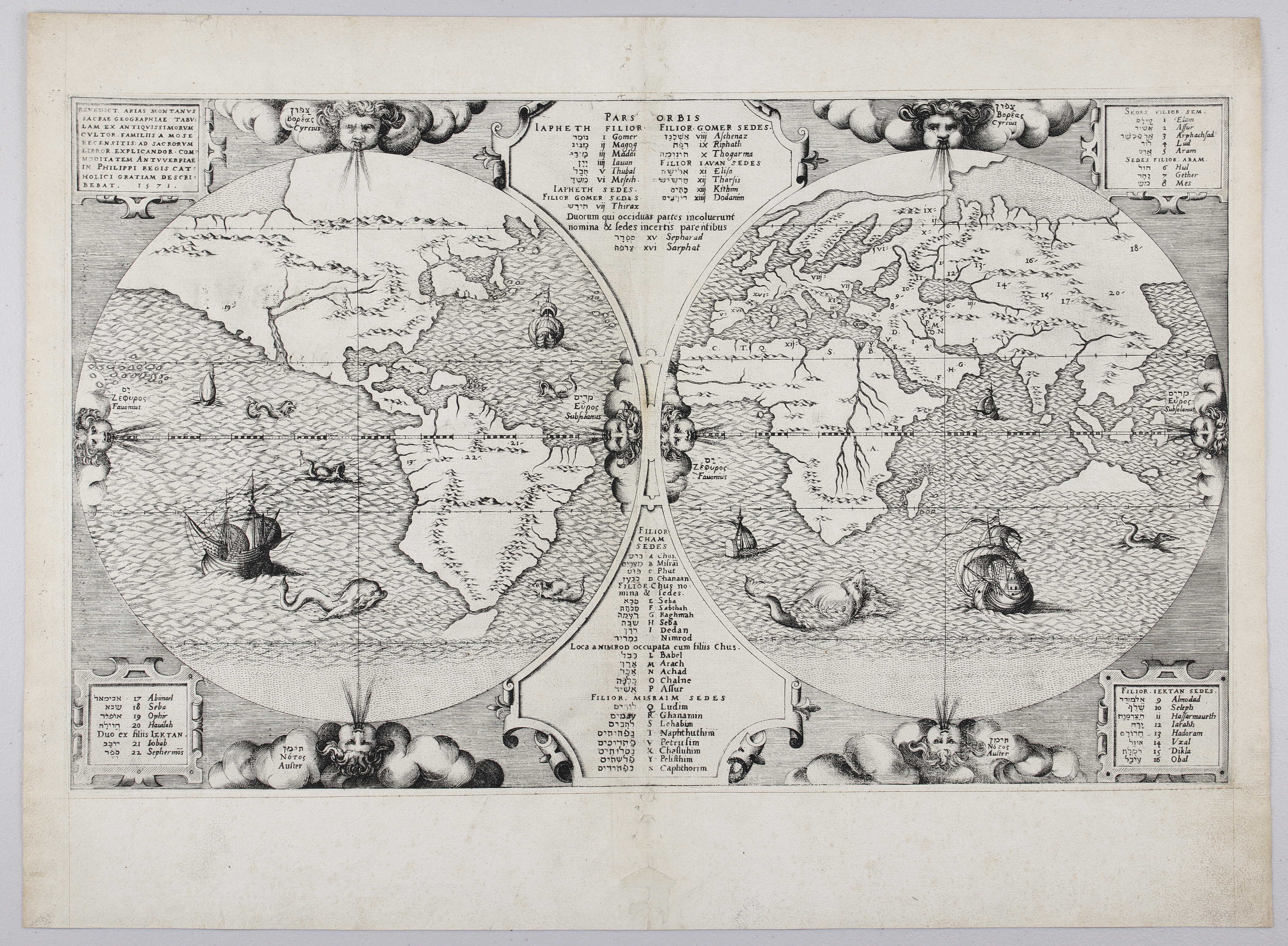
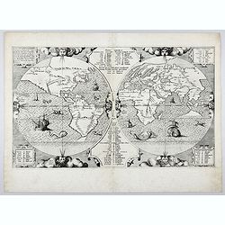
THE EXTREMELY RARE FIRST STATE landmark world map, famed for its depiction of the Australian landmass.One of the earliest printed maps to depict the “terra incognita” of a then “undiscovered” Australia. The only similar printed map with claims to show Australia before
the Dutch discoveries was a world map by the German theologian Heinrich
Bünting in his Itinerarium in 1581. The map was edited by Benito Arias, known as Montanus after his birthplace. This well-engraved map appeared in Biblia Sacra, Hebraica... in 1572. The Polyglot Bible, with text in Hebrew, Greek, Latin and Syriac was prepared under the patronage of Philip II of Spain and published between 1569 and 1572, with the printing being carried out by Plantin of Antwerp.
This is the extremely rare first edition and first state of the Arias Montanus Orbis
Tabula or Map of the World, engraved in 1571, and published in 1572.
This state of the
map is very rare since a shipment of bibles, including this map, were
lost in a storm in the North Sea, sailing on route from Flanders (XVII
Provinces) to the north coast of Spain. The maps from the first edition have been printed on
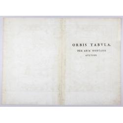
the reverse "Orbis Tabula. Ben. Aria Montano. Auctore".
The bibles in question -the Biblia Regia - were the monumental royal polyglot bibles prepared by friar Benito Arias Montanus, an eminent Spanish theologist, part-time librarian at the Royal Monastery of San Lorenzo de El Escorial near Madrid and confident of Spanish King Philip II.The map ORBIS TABULA by Montanus, was included in the final volume
of this huge bible, Volume VIII or Apparatus. Apparently, of this VOLUME
VIII only 500 copies were printed by Plantin in 1571-1572. Montanus
got access to “updated” geographical information while attending, as a
Spanish delegate, the third session of the Council of Trent in northern
Italy (1562-1564).
The map includes Hebrew and Latin (for the
identification and numeric worldwide-location of the descendants of
Noah) and ancient Greek (indicating the wind denominations).The
map tells the aftermath of God’s punishment (the language confusion)
followed by the exile and dispersion from Babylon of the sons of Noah
after they dared to build the Tower of Babel.As a catholic
apologist to Philip King of Spain and his brutal general the Duke of
Alva in the persecution of protestant heretics in the Low Countries
(then under Spanish Rule) , Benito Arias Montanus shows in this map that
– according to his interpretation – due to his novel geographical
eastern landmass connection between Asia and America, the treasures of
Paradise Lost finally ended up in the newfound Spanish Eldorado (with
the mines of Potosi as epicentre) in America, guarded by the descendants
of Sem.
And that gold, silver and jewels would
provide the Spanish Habsburg Dynasty (the descendants of Japhet) with
the necessary means not only to stem the spread of the protestant virus
but to join the world in an “all-catholic” empire (a “universe”, where
the sun did not go down) since a new and costly crusade was needed to
liberate Jerusalem of any “infidels” and prepare for the Second Coming
of Christ.
Also, the intriguing thing about this map is an unexplained
landmass, suggesting Portuguese knowledge of the northern coastline of
Australia long before the official discovery by the Dutch of Australia
in 1606.All the above indicates that this map in the first
state is a very important item for any serious map collection of
“Australia” and/or “Geografia Sacra”.
The map offered here is the first state of the map as commented by Shirley in his monumental work “The Mapping of the World”:The
map from the first edition, of which the greater number of impressions
were lost at sea on route for Spain, has printed on the reverse Orbis
Tabula. Ben. Aria Montano. Auctore. In state 2 the word gentes has been
added below the word Iektan in the lower left panel. Mr Tully of
Australia has advised me of a second plate with minor but significant
differences in treatment. The date (1571) is now placed centrally to
conclude the title, lektan is spelled Ioktan, and the cherub at the head
of the western hemisphere is unambiguously gazing to the left compared
to the frontwards look of the same cherub in plate 1.The map was widely
admired throughout the succeeding century."
The loss of most examples
of the first state in a shipwreck resulted in only a handful of
examples of this map appearing on the market in the last decades: for
instance, Martayan Lan for $20,000 in 2003, Arkway for $18,000 in 2006
and Ruderman for $ 24,500 presently.
Montanus (supposedly a Marrano or falsely reconverted jew) was also an excellent linguist and polyglot, and his polyglot bible also called the Biblia sacra hebraice chaldaice, graece et latine , also known as the Biblia Regia or Royal Bible contained five languages : Syriac, Latin, Greek, Aramaic and Hebrew. The Montanus bible was supposed to be an improvement on the Complutensian Polyglot Bible or Alcala Bible, first published in 1520 near Madrid and promoted by catholic Cardenal Cisneros to please and help emperor Charles V (father of Philip II) in his struggles against the “infidels”.
As from 1568, Montanus spent several years in Antwerp, residing in the
Officina Plantiniana, or the printing press of Christophe Plantin, who
was the greatest typographer and printer-publisher of his day. Plantin,
as the official printer of Spanish King Philip II, or Prototypographus
Regius , then held the monopoly on printing religious works for the
expanding Spanish, European and colonial market.
Indeed, these multi-lingual bibles, basically still promoting the official Vulgata-version, were supposed to be distributed all over the Spanish Empire as to facilitate the universal conversion of “unbelievers” (who did not necessarily mastered Latin) to the one and only true Catholic faith. A rare copy of Montanus’s polyglot eight Volumes Bible including this world map in the first state, was acquired at auction by the Phoebus Foundation in the year 2018 for $700,000.
This state of the map is very rare since a shipment of bibles, including this map, were lost in a storm in the North Sea, sailing on route from Flanders (XVII Provinces) to the north coast of Spain.
The loss of most examples of the first state in a shipwreck resulted in only a handful of examples of this map appearing on the market in the last decades: for instance, Martayan Lan for $20,000 in 2003, Arkway for $18,000 in 2006 and Ruderman for $ 24,500 presently.

Reference: Shirley, World 125, Clancy, Map 5.7.
FAQ - Guarantee - Shipping
Buying in the BuyNow Gallery
This item is available for immediate purchase when a "Add to Cart" or "Inquire Now" button is shown.
Items are sold in the EU margin scheme
Payments are accepted in Euros or US Dollars.
Authenticity Guarantee
 We provide professional descriptions, condition report (based on 45 years experience in the map business)
Paulus Swaen warrants the authenticity of our items and a certificate of authenticity is provided for each acquired lot.
Condition and Coloring
We indicate the condition of each item and use our unnique HiBCoR grading system in which four key items determine a map's value: Historical Importance, Beauty, Condition/Coloring and Rarity.
Color Key
We offer many maps in their original black and white condition. We do not systematically color-up maps to make them more sellable to the general public or buyer.
Copper engraved or wood block maps are always hand colored. Maps were initially colored for aesthetic reasons and to improve readability. Nowadays, it is becoming a challenge to find maps in their original colors and are therefor more valuable.
We use the following color keys in our catalog:
Original colors; mean that the colors have been applied around the time the map was issued.
Original o/l colors; means the map has only the borders colored at the time of publication.
Colored; If the colors are applied recently or at the end of the 20th century.
Read more about coloring of maps [+]
Shipping fee
A flat shipping fee of $ 30 is added to each shipment by DHL within Europe and North America. This covers : International Priority shipping, Packing and Insurance (up to the invoice amount).
Shipments to Asia are $ 40 and rest of the world $50
We charge only one shipping fee when you have been successful on multiple items or when you want to combine gallery and auction purchases.
Read more about invoicing and shipping
FAQ
Please have a look for more information about buying in the BuyNow gallery
Many answers are likely to find in the general help section.
My Collection+
![]()
With My Collection+ you can collect all your favorite items in one place. It is free, and anyone can create his or her virtual collection.
Unless you are logged in, the item is only saved for this session. You have to be registed and logged-in if you want to save this item permanently to My Collection+.
Read More[+]
Register here, it is free and you do not need a credit card.
Add this item to
My Collection+
or click the following link to see My Collection+.
| Digital Image Download | |
|
Paulus Swaen maintains an archive of most of our high-resolution rare maps, prints, posters and medieval manuscript scans. We make them freely available for download and study. Read more about free image download |
Click the image for a free small image download. |
In accordance with the EU Consumer Rights Directive and habitually reside in the European Union you have the right to cancel the contract for the purchase of a lot, without giving any reason.
The cancellation period will expire 14 calendar days from the day after the date on which you or a third party (other than the carrier and indicated by you) acquires, physical possession of the lot. To exercise the right to cancel you must inform Paulus Swaen Inc, of your decision to cancel this contract by a clear statement (e.g. a letter sent by post, or e-mail.
To meet the cancellation deadline, it is sufficient for you to send your communication concerning your exercise of the right to cancel before the cancellation period has expired.
Recently Viewed
Benedict. Arias Montanus Sacrae Geographiae Tabulam Ex Antiq
THE EXTREMELY RARE FIRST STATE landmark world map, famed for its depiction of the Australian landmass.One of the earliest printed maps to depict the “terra incognita” of...
Date: Anvers 1571 /1572
