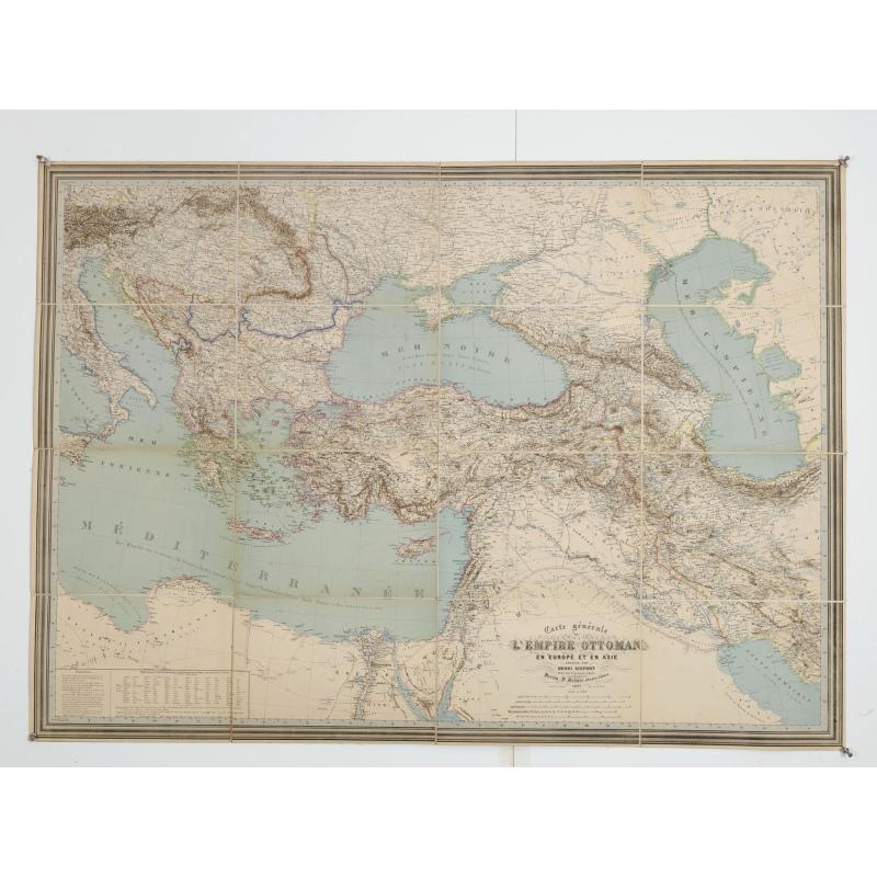
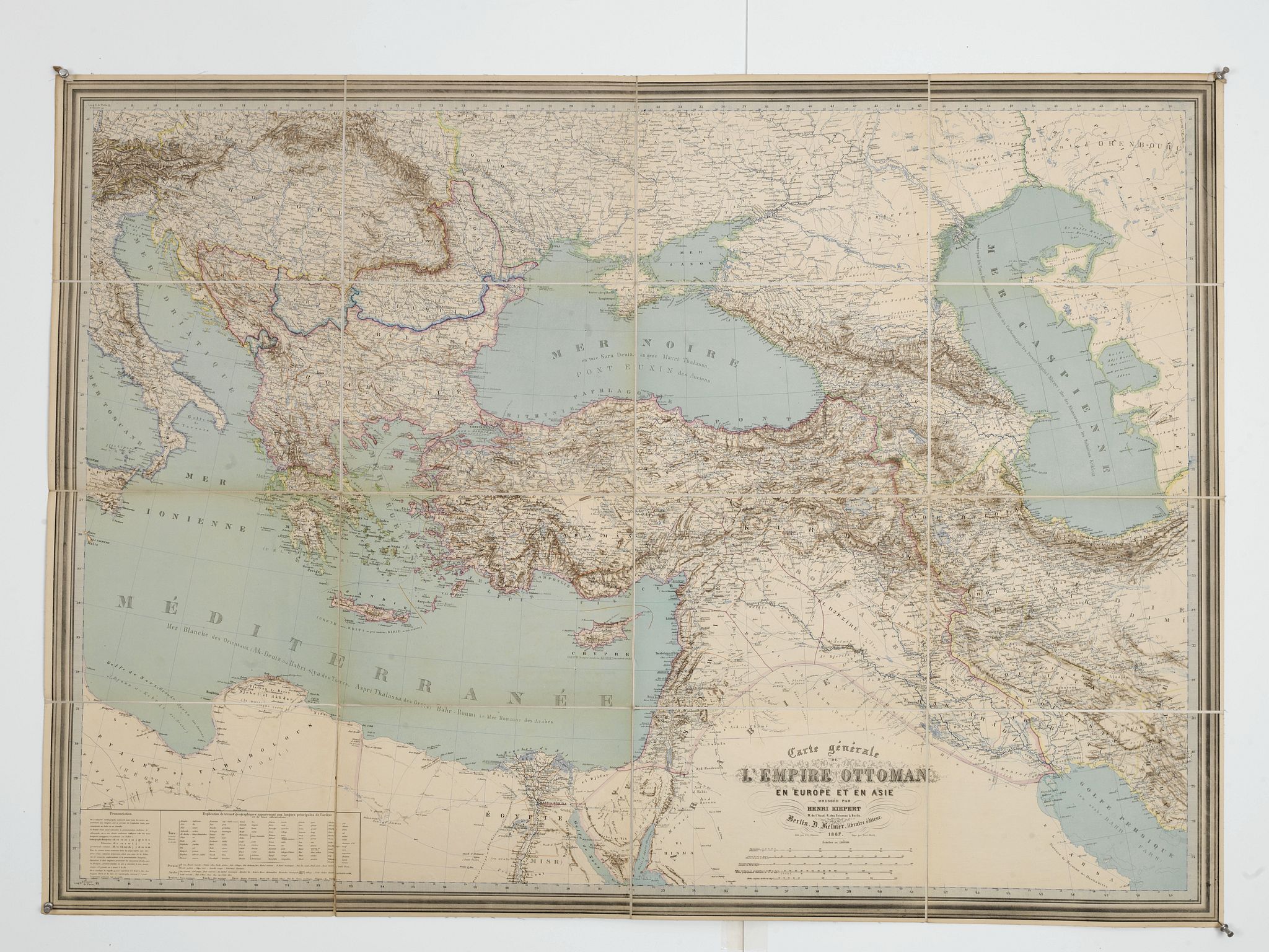
Carte générale de L'Empire Ottoman en Europe et en Asie dressée par Henri Kiepert . . . |
||||||||||||||||||||
|
||||||||||||||||||||
|
|
||||||||||||||||||||
$1750 / ≈ €1538This item is available for immediate sale! Questions before Buying ?
We are happy to answer your questions. |
My Collection +
Add this or any of your favorite items in one place. If you want to save the items permanently, you have to sign in or create an account first. |
|||||||||||||||||||
Description
Large School wall map of Turkish Empire printed in chromo-lithography. Published by Dieter Reimer and printed by Ferdind Barth in Berlin.
This rare map has two insets in lower left corner "Prononciation" and "Explication de termes géographiques appartenant aux langues principales de l'orient et de leurs abbreviations".
Geographer Heinrich Kiepert (1818-1899) is generally reckoned one of the more important scholarly cartographers of the second half of the 19th century. Kiepert acquired one of his interests— the historical geography of the classical world— in his student days at the University of Berlin, where he worked with Carl Ritter (1779-1859).
Ritter and Kiepert produced what appears to have been one of the first modern atlases of the ancient Greek world, Topographisch-historischer Atlas von Hellas und den hellenischen Colonien in 24 Blättern (1840-1846).
Several additional compilations of maps of the classical world followed: Bibel-Atlas (1847). Historisch-geographischer Atlas der alten Welt (1848), Atlas antiquus (1854). Formae orbis antiqui (1893) and Formae urbis Romae antiquae (1896). Many of these works were reissued in numerous editions, including translations.
Another major interest was the Ottoman Empire, where Kiepert travelled numerous times, gathering enough data to produce several major maps of the Ottoman world between the 1840s and 1890s.
Kiepert was also responsible for some of the first detailed ethnic maps of Germany, Austria-Hungary, and the Balkan Peninsula. In the course of many years, he compiled maps of much of the rest of the world as well, in addition to cartographic materials for schools.
Kiepert was head of the Geographisches Institut in Weimar between 1845 and 1852 and professor at the University of Berlin from 1852. He maintained a long association with the publisher Dietrich Reimer. Many later editions of Kiepert's maps were updated by his son, Richard Kiepert (1846-1915).
Kiepert's maps are almost invariably clear and easy to read, and they are as accurate as the scholarship of the day permitted. His maps of the historical geography of the classical world have inevitably come to seem a bit old-fashioned in light of later research, but his maps of the Ottoman Empire and surrounding countries remain extraordinarily valuable records of conditions in the period when they were compiled.
The map is very rare. See : University of Chicago Library's Map Collection" for more details.
Provenance : "Comte A. Duchastel" (with his signature. Adolphe du Chastel de la Howarderie, Comte du Chastel de la Howarderie was born in 1851 at Wez-Velvain, Belgium. He married Marie Josephe von Croÿ, daughter of Juste Marie Fernand Victurien Prinz von Croÿ and Marie-Magdelaine d'Ursel, Comtesse d'Ursel, in 1882 at Brussels, Belgium. He died in 1918 at Capelle, Franc. He gained the title of Comte du Chastel de la Howarderie.
Kept in its original cover with stamp of book seller Marango & Vassilicopoule in Istanbul.
Read more about wall maps [+]
FAQ - Guarantee - Shipping
Buying in the BuyNow Gallery
This item is available for immediate purchase when a "Add to Cart" or "Inquire Now" button is shown.
Items are sold in the EU margin scheme
Payments are accepted in Euros or US Dollars.
Authenticity Guarantee
 We provide professional descriptions, condition report (based on 45 years experience in the map business)
Paulus Swaen warrants the authenticity of our items and a certificate of authenticity is provided for each acquired lot.
Condition and Coloring
We indicate the condition of each item and use our unnique HiBCoR grading system in which four key items determine a map's value: Historical Importance, Beauty, Condition/Coloring and Rarity.
Color Key
We offer many maps in their original black and white condition. We do not systematically color-up maps to make them more sellable to the general public or buyer.
Copper engraved or wood block maps are always hand colored. Maps were initially colored for aesthetic reasons and to improve readability. Nowadays, it is becoming a challenge to find maps in their original colors and are therefor more valuable.
We use the following color keys in our catalog:
Original colors; mean that the colors have been applied around the time the map was issued.
Original o/l colors; means the map has only the borders colored at the time of publication.
Colored; If the colors are applied recently or at the end of the 20th century.
Read more about coloring of maps [+]
Shipping fee
A flat shipping fee of $ 30 is added to each shipment by DHL within Europe and North America. This covers : International Priority shipping, Packing and Insurance (up to the invoice amount).
Shipments to Asia are $ 40 and rest of the world $50
We charge only one shipping fee when you have been successful on multiple items or when you want to combine gallery and auction purchases.
Read more about invoicing and shipping
FAQ
Please have a look for more information about buying in the BuyNow gallery
Many answers are likely to find in the general help section.
My Collection+
![]()
With My Collection+ you can collect all your favorite items in one place. It is free, and anyone can create his or her virtual collection.
Unless you are logged in, the item is only saved for this session. You have to be registed and logged-in if you want to save this item permanently to My Collection+.
Read More[+]
Register here, it is free and you do not need a credit card.
Add this item to
My Collection+
or click the following link to see My Collection+.
| Digital Image Download | |
|
Paulus Swaen maintains an archive of most of our high-resolution rare maps, prints, posters and medieval manuscript scans. We make them freely available for download and study. Read more about free image download |
Click the image for a free small image download. |
In accordance with the EU Consumer Rights Directive and habitually reside in the European Union you have the right to cancel the contract for the purchase of a lot, without giving any reason.
The cancellation period will expire 14 calendar days from the day after the date on which you or a third party (other than the carrier and indicated by you) acquires, physical possession of the lot. To exercise the right to cancel you must inform Paulus Swaen Inc, of your decision to cancel this contract by a clear statement (e.g. a letter sent by post, or e-mail.
To meet the cancellation deadline, it is sufficient for you to send your communication concerning your exercise of the right to cancel before the cancellation period has expired.
Recently Viewed

Carte générale de L'Empire Ottoman en Europe et en Asie dressée par Henri Kiepert . . .
Large School wall map of Turkish Empire printed in chromo-lithography. Published by Dieter Reimer and printed by Ferdind Barth in Berlin. This rare map has two insets in ...
Date: Berlin, Verlag von Dietrich Reimer, 1867
