Featured Listings
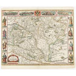
The mape of Hungari newly augmented by John Speede.
A wonderful carte-a-figures map of ‘Hungari’, comprising modern-day Hungary and parts of Slovakia. Showing two sets of four costumed figures on each side of the map and v...
Date: Londres, Bassett and Chiswell, 1626 / 1676

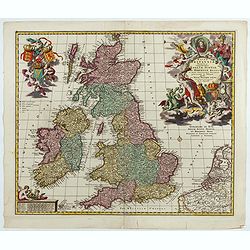
EUROP, and the cheife Cities contayned therin described. . .
A good impression from an early edition of this famous and decorative "carte à figures"- map from the first world atlas produced by an Englishman - John Speed's...
Date: London, 1627 - 1676

(Totius Americae nova et exacta tabula ex) optimis tum geographorum tum aliorum scriptis collecta et ad hodiernam regnorum principatuum et maiorum partium distinctionem accomodata.
Eastern part of a two-sheet map of America, with attribution to Willem Blaeu. According to Philip Burden, the map was derived from Cornelius Danckert's 1647 map of the sa...
Date: Rome, 1679

Nova Orbis Tabula in Lucem edita A.F.de Wit.
According to Shirley, De Wit's map is one of the most attractive of its time. The brilliant scenes in the corners combine images of the four seasons, the elements, and th...
Date: Amsterdam, 1680

Ignographia candiae tertia a turcis obsessae in lucem edita a F. de Wit.
A scarce broadsheet plan and view of Heraklion on one sheet: prospect 180 x 495mm, map 395 x 495mm., in the lower part a printed description "Abbildung der starken S...
Date: Amsterdam, 1680

Nova Totius Terrarum Orbis Geographica ac Hydrographica Tabula.
A beautifully decorative world map taken from the 'English Atlas' by Moses Pitt and Steven Swart, based on an earlier engraved world map by Pieter van den Keere ca. 1630,...
Date: Oxford, 1680
-250x250.jpg)
Hern Johann Baptisten Taveniers..Vierzig Jaehrige Reize..
This German edition includes Tavernier's map of Japan in a reduced form (210x315mm) and contains legends about the country's nature, e.g., where gold is mined and plottin...
Date: Nuremberg, 1681

Waere affbeeldinge wegens het casteel ende stadt Batavia.
A good impression of this finely engraved and detailed plan of Batavia, present-day Jakarta, the Dutch center of trading activities in the East Indies. Copied after Cleme...
Date: Amsterdam, 1681

Jerusalem.
Engraved by Bastiaan Stoopendaal from Juan Bautista Villapando's imaginary town-plan of Jerusalem. This bird's-eye view is surrounded by 12 scenes, views and portraits of...
Date: Amsterdam, 1682

Il regno della China detto presentente Catay e Magnin. . .
A rare and decorative Italian map of China and Japan, with Japan closely modelled on the indented Cardim outline and Hokkaido, called Yuppi , shown as an Asian peninsula....
Date: Rome, 1682

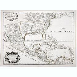
La Floride. . .
The map is derived from La Floride , 1657, by Nicolas Sanson. Several new rivers appear in Virginia. The Caroline listed is Ft. Caroline, not the Carolinas. The Florida n...
Date: Paris, 1683

Het Hooge Heemraedtschap van Schielandt.
This beautiful wall map of "Het Hooge Heemraedtschap van Schielandt" is on nine attached leaves (each leaf 49x58,5 cm. ) engraved by J. VINGBOOMS after J.J. STA...
Date: Rotterdam, A. van Hoorn, 1684

Novi Belgii novae que Angliae nec non partis Virginiae..
With the arrival of Dutch and other European colonists, the landscape of New Netherland changed dramatically. The third state, with Fort Kassimier and Philadelphia, and n...
Date: Amsterdam, 1684

Paradigma XV Provinciarum et CLV Urbium Capitalium Sinensis Imperij Cum Templis quae Cruce X Signatur Et Domiciliis S.I.
First edition of this rare Jesuit map of China, published by Jean Baptiste Nolin in Paris and based on Philippe Couplet's map of 1686. The map shows China's 15 provinces ...
Date: Paris, 1686

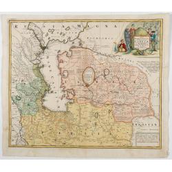
Carte du Palatinat du Rhin.
Decorative "carte à figures"- map centered on Koblenz, Metz, Strasburg, Manheim and Heidelberg, with the river Rhine by François Jollain (ca. 1641 – 18 April 17...
Date: Paris, ca. 1688

Archipelague du Mexique ou sont les Isles de Cuba..
Scarce map of Caribbean. A visually stunning map with a large title cartouche. This large one-sheet map was produced by the Venetian cosmographer Vincenzo Coronelli when ...
Date: Paris, 1688

Les vallées du Piemont. Habitees par les Vaudois ou Berbets. . .
Detailed map of Piedmont region covering French and Italian territories. Surrounded by a French text description "Description des vallées du Piemont qu'habitent par ...
Date: Paris, 1690
![America Settentrionale Colle Nuove Scoperte Sin All Anno 1688. . . (together with] America meridionale . . .](/uploads/cache/49063-250x250.jpg)
America Settentrionale Colle Nuove Scoperte Sin All Anno 1688. . . (together with] America meridionale . . .
Gorgeous example of Coronelli's famous four- sheet map of America. One of the best examples of California as an island. The map also includes extensive annotations on the...
Date: Venice, 1690

Isola di Madagascar o di S. Lorenzo Scoperta dà Portoghesi nell anno 1506. . .
Decorative and highly detailed map of Madagascar, including 2 decorative cartouches and other embellishments.The remarkable Vincenzo Coronelli (1650-1718), was a Francisc...
Date: Venice, 1690

L'Africa divisa nelle sue Parti secondo le pui moderne . . .
A beautiful and rare two-sheet map of Africa. The title cartouche is depicted on a drape surrounded by native animals.A most noticeable feature of the decoration on the m...
Date: Venice, 1690

Magnae Prussiae Ducatus Tabula denuo correcta et in lucem edita per Nicolaum Visscher.
Striking old color example of Visscher's map of Prussia and part of the Baltic region. Includes a gorgeous cartouche and banner key held aloft by 2 cherubs, plus 4 sailin...
Date: Amsterdam, 1690

Saique batiment dont les turcs se servent. . .
A very decorative engraving of a Turkish vessel. From Mortier's famous maritime Atlas "Neptune François". Engraved by Jan van Vianen after a design by Henri Sbo...
Date: Amsterdam, 1690

Le comte de Namur et partie des Duchez de Brabant. . .
Decorative map centered on Namen and including the towns of Liege, Leuven, Charleroi, Dinant, Luxemburg, etc. by François Jollain (ca. 1641 – 18 April 1704).Rare "ca...
Date: Paris, c. 1692
![Amerique Septentrionale divisée en ses principales parties. . .1692. [California as an Island]](/uploads/cache/27961-250x250.jpg)
Amerique Septentrionale divisée en ses principales parties. . .1692. [California as an Island]
A very good impression of Jaillot's large map of North America, showing California as an Island, based upon Sanson's landmark map of 1656. A first state.The map shows the...
Date: Amsterdam, c.1692

Het gezandtschap der Neerlandtsche Oost-Indische Compagnie, aan den grooten Tartarischen Cham, Den tegenwoordigen Keizer van China. . .
Third edition of this beautifully illustrated work on China. The first edition was published in 1665.Jan Nieuhof was a "Dutch traveler and adventurer" (1618-72)...
Date: Amsterdam, W. Waasberge, 1693
Magnae Britaniae Tabula; Comprehendens Angliae, Scotiae, Ac Hiberniae Regna . . .
Rare Dutch map of the British Isles in very attractive full original color. In this state the wording "Scilly Isles" is added. A decorative title cartouche in t...
Date: Amsterdam, after 1694

Vaisseau du premier rang portant pavillon d'amiral.
Fine double-page engraved plate of a naval vessel, with the various parts of the ship numbered and identified. From Mortier's "Neptune François". From Mortier's...
Date: Amsterdam, 1695

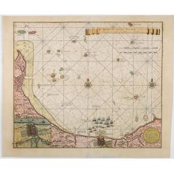
A plat of the East Sea. By William Fisher and Richard Mount...
An important sea chart of the East Sea with coast lines of Poland, Russia, Sweden, published by William Fisher and Richard Mount in London.Richard Mount (1654-1722) was a...
Date: London, 1695

Parte orientale della China.. / Parte occidentale della China. (2 sheets)
The map depicts the eastern part of China with Korea -correctly- as a peninsula. Formosa is included as well. Japan is partly visible i.e. the area of Yamaguchi, strait K...
Date: Venice, 1695
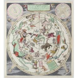
Nieuwe Hemels Spiegel waer door den hemel, aerde en zee dadelik kan afgemeten werden. Noyt gesien en dat op alles Polus hooghten seer noodig voor Stierlieden.
Copper engraving made by Andreas van Luchtenburg in Rotterdam, published separately by Cornelis Danckerts. We see the starry sky as observed from the northern hemisphere...
Date: Danckerts, ca. 1700

Chorographia Terrae Sanctae in Angustiorem. . .
Rare. Large visually rich map decorated with illustrations of the sacred objects and places of Judaism. In the bottom center is a plan of ancient Jerusalem, and the route...
Date: Amsterdam, ca. 1700

Volna.
Very decorative and rare panoramic town-view of Volna. We have more Anna Beek prints available.The engraver and publisher of prints, Mrs. Anna Beek of the Hague, enlarge...
Date: The Hague, ca. 1700

Tschopau.
Very decorative and rare panoramic of Tschopau.The engraver and publisher of prints, Mrs. Anna Beek of the Hague, enlarged the print and mounted it on larger paper: she ...
Date: The Hague, ca. 1700
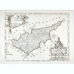
Acamantis insula hogidi Cipro . . .
Decorative map of Cyprus. The remarkable Vincenzo Coronelli (1650-1718), was a Franciscan Friar and appointed General of the Order in 1701. He was cosmographer to the Rep...
Date: Venice, 1700

Launa vulgo Laun Bohemiae civitas.
Bird's-eye views of Louny in Bohemia by G. Hoefnagel. The copperplate was made for Braun and Hogenberg's town book. However there the print has been transformed by the en...
Date: The Hague, 1700

Novissima Flandriae Comitatus tabula. . .
Rare issue of Theodorus Danckert's attractive map of eastern Belgium provinces, Flanders, with Brugge, Oostende, Gent, Mons, Antwerp, Cambray, etc..Decorative title carto...
Date: Amsterdam, 1700
Carte du Mexique et de la Floride.
Third state, with "Quai de l'Horloge" imprint. Renard’s imprint has been erased”. It was the first printed map to portray accurately the course and mouth of the...
Date: Paris, 1703

Het Friessche Doolhoff, het beruchte dorp Molk-Worren
Uncommon map made in 1718 by Johannes Hilarides, principal at the Latin School in Bolsward.. Probably the only printed plan of a Frisian village of that time. The map was...
Date: Amsterdam, 1705

La mer Mediterranee divisee en ses principales parties ou mers. . .
Very large map centered on the Mediterranean. With a sub title along upper margin "La Mer Mediterranée divisée en Mer de Levant et de Ponant Subdivisées en Leurs Pri...
Date: Amsterdam, c.1705

Horizon ring for globe.
Printed horizon ring for a 28cm diameter German globe. The ring is divided in quarters and engraved two by two on one copper plate. The size of the paper is 44 x 33cm. Th...
Date: Nuremberg, 1704/1705

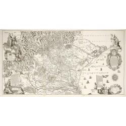
LA RUSSIE ROUGE ou POLONOISE qui Comprend les PROVINCES DE LA RUSSIE ROUGE de VOLHYNIE et de PODOLIE divisées en leurs Palatinats Vulgairement Connües sous le Nom D'VKRAINE ou PAYS DES COSAQUES.
A very rare Sanson map of Ukraine and so-called Russie Rouge, stretching from Lublin in the west to Kherson Oblast in the east (here called "Confin de La Petite Tart...
Date: Paris, 1706
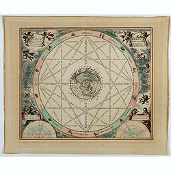
Typus aspectuum, oppositionum et conjunctionum…
A celestial chart with a circular projection map of the Earth, centered at the North Pole, concentrates on the planets' opposition and conjunction. With two diagrams in t...
Date: Amsterdam, 1708

De Haven en Straat von Gibraltar, Niewlyks getekend, en in`t licht gebracht door Johannes Covens en Cornelis Mortier tot Amsterdam.
Decorative map showing the siege of Gibraltar during the Spanish war of succession. This highly interesting map is richly ornated with three additional inset maps and vie...
Date: Amsterdam, 1710

De Stadt Jerusalem.
Plan of ancient Jerusalem from a Dutch bible after Villalpando. The print is in contemporary colors, which is extremely rare for a plate like this. Lower left the Temple ...
Date: Amsterdam, 1710

Nansenbushu bankoku shoka no zu.
This wall-map is a great example of Japanese world maps representing Buddhist cosmology with real-world cartography. It is the earliest one and - therefore - the prototyp...
Date: Kyoto, (Hoei 7 = Year of the Tiger) 1710
![Le Royaume de Siam avec Les Royaumes Qui Luy sont Tributaries & c. / La Royaume de Siam avec les royaumes qui luy sont Tributaires, et les Isles de Sumatra, Andemaon, etc. . . [two sheet map]](/uploads/cache/40698-250x250.jpg)
Le Royaume de Siam avec Les Royaumes Qui Luy sont Tributaries & c. / La Royaume de Siam avec les royaumes qui luy sont Tributaires, et les Isles de Sumatra, Andemaon, etc. . . [two sheet map]
Influential map of Southeast Asia and the East Indies including modern day Thailand, southern Vietnam, Cambodia, Malaysia, Singapore, Borneo, Sumatra and Java. Ottens inc...
Date: Amsterdam, 1710

De golf van Bengalen.
Rare chart of the Indian Ocean, with nice detail on Ceylon (Sri Lanka) with compass roses and a system of rhumb lines, soundings and anchorage's. Many place names. The pl...
Date: Amsterdam, after 1669-1712

A new and correct map of the world.
The early eighteenth century was one of the most important periods for English cartography. One of the period's most intriguing world maps is this large-scale map, which ...
Date: London 1714
![Recueil de costumes. Imagini degl'abiti con cui Va uestita la Nobiltà della Serenis.ma Republica di Venezia. Suivi de: [Augsburger Kleidertrachten].](/uploads/cache/48425-250x250.jpg)
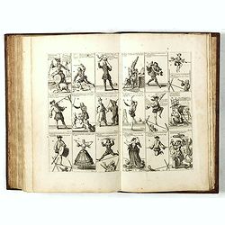
Recueil de costumes. Imagini degl'abiti con cui Va uestita la Nobiltà della Serenis.ma Republica di Venezia. Suivi de: [Augsburger Kleidertrachten].
Imagini degl'abiti con cui Va uestita la Nobiltà della Serenis.ma Republica di Venezia. Dedicate all'Illmo et Ecc.mo Sig.r Andrea da Leze Degnis.mo Proc.tor di S: Marco. ...
Date: Venezia, Ragheno, 1702 / Augsbourg, J. Wolff, ca. 1715
Nieuwe kaart van Suriname vertonende de stromen en land-streken van Suriname, Comowini, Cottica en Marawini, gelegen in Zuid America op de kusten van Caribana. . .
Decorative full color example of Ottens' map of Suriname. Detailed map of the northeast part of Suriname between Paramaribo, with fort Zeelandia, and Mana.Along the Surin...
Date: Amsterdam, ca. 1713-1718

Stoel des Oorlogs in America Waar in Vertoont Werden Alle Desself Voornaamste Eylande . . .
Large impressive map of the West Indies with the Gulf of Mexico and Florida. The map shows prominently in the center Cuba, Haiti, the Bahamas and Florida, which is here m...
Date: Amsterdam, c. 1720
Diocesi Padovana Con Tutta La Sua Estensione Ne Vicini Territori.
This large map depicts the entire extent of the Diocese of Padua and the surrounding territories, with a detailed topographical rendering. It features rich Baroque ornam...
Date: Padova, 1720

Vue et description des principales villes de l'Armenie et de la Georgie avec les habillements des femmes du pays, et ceux des prêtres et religieux armeniens. . .Tom: V N° 11 Pag: 28
View and description of the principal Armenian and Georgian cities with illustrations of Armenian women's garments as well as priests' and monks' clothing. The views are ...
Date: Amsterdam, ca 1720
Het Groote Tafereel der Dwaasheid, vertoonende de opkomst, voortgang en ondergang der Actie, Bubbel en Windnegotie, in Vrankryk, Engeland, en de Nederlanden, gespleegt in den Jaare MDCCXX...
1720 - With 78 plates of the first banking crash, showing the shocking effects of the “South Sea Bubble” in France, England and Holland, and placing John Law with his Mis...
Date: Amsterdam, 1720

Nova tabula geographica complectens borealiorem..
A finely engraved pair of maps designed to be cut and joined together to provide a continuous coastline of North America from the Carolinas to Newfoundland and along the ...
Date: Amsterdam 1720

Waere Affbeeldinge Wegens het Casteel ende Stadt BATAVIA Gelegen opt Groot Eylant Java.
A good impression of this finely engraved and detailed plan of Batavia, present-day Jakarta, the Dutch center of trading activities in the East Indies. Copied after Cleme...
Date: Amsterdam, 1721

Plan de la ville de Malthe ses Forts, ses Nouvelles Fortiffications. . .
Detailed plan of Valletta. In upper right corner a key (A-Z & 1-32) to the principal places in town. Prepared by N.de Fer and re-issued by Danet.
Date: Paris, 1723
![[12 volumes] Recueil des voyages qui ont servi à l'établissement et aux progrez de la Compagnie des Indes Orientales, forméedans les Provinces-Unies des Païs-Bas...](/uploads/cache/43700-250x250.jpg)
[12 volumes] Recueil des voyages qui ont servi à l'établissement et aux progrez de la Compagnie des Indes Orientales, forméedans les Provinces-Unies des Païs-Bas...
An important, richly illustrated compendium of the first Dutch voyages to East India, of great interest for the history and establishment of the Dutch global trade, parti...
Date: Rouen, Pierre Le Boucher, 1725
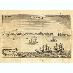
Ormus. (Hormuz)
This very interesting early engraving shows the ships of the Dutchman Van den Broecke, who in December 1628 left his directorship in Surat. Before returning to Batavia he...
Date: Amsterdam, F. Bernard, 1725
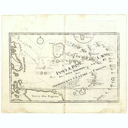
Insulae Palaos seu Novae Philippinae 87 Alias Archipelagus S. Lazari ven Carolinae . . .
Map of Philippine archipelago. Stöcklein's work is a compound of letters of the Jesuit missionaries from all over the world and here particularly the ones stationed at th...
Date: Augsburg, 1726

Die Insel Formosa neu abgemessen auf Befehl Kaysers Kamhi.
One of the earliest obtainable printed maps of Taiwan or Formosa Island. It was issued around 1726 to illustrate Joseph Stöcklein's [Stoecklein] compilation of Jesuit mis...
Date: Augsburg, 1726

Nieuwe Caart der Eylanden van Banda.
Decorative map of the Banda Islands. Until the mid-19th century the Banda Islands were the world's only source of the spices nutmeg and mace, produced from the nutmeg tre...
Date: Amsterdam, 1726

Nieuwe Kaart van het Eyland Sumatra..
Fine chart depicting the Island of Sumatra and the southern coasts of Malaysia from Quedo to Johore. North is orientated to the left of the page. Singapore is probably id...
Date: Amsterdam, 1726

Great or Asiatick Tartary, Agreable to Modern History.
Map of Tartary to Peking. The eastern coastline of Asia is almost flat, with no attempt to mark Kamchatka. The Caspian Sea in the lower left, with present-day Uzbekistan ...
Date: London, 1727
De Reede en stadt Batavia is geleegen aan de Noord Kust…
A chart of the bay of Batavia with in lower left corner a plan of Batavia (120x147mm). This very rare and influential chart gives a fine representation of Batavia, now kn...
Date: Amsterdam, 1728

Histoire Naturelle, Civile, Et Ecclésiastique..'
First French edition, published by P. Gosse, J. Neaulme and B. Lakeman. The basic work on Japan from the second half of the 17th century when it was still forbidden for f...
Date: Amsterdam, 1729

Colossus Monarchic. Statua Danielis
Fantastic double page allegorical map of a colossus figure representing the great world empires as Daniel interpreted in Nebuchadnezzar's dream. The warrior stands stolid...
Date: Augsbourg, 1730

Insularum Moluccarum Nova description.
Exquisite map of the famous Spice Islands based. This map was the first large-scale map of the region and depicts the islands which provided first the Portuguese and then...
Date: Amsterdam, 1730

Vorstellung der Evangelisch-Ostindischen Kirche Augsburger Protestanten.
It is a very decorative and rare print to commemorate the 200-year Confession of the Augsburg Protestant Confession. Engraved by J. Kleinschmidt after a design of E. Ridi...
Date: Augsburg, 1732

Lo Stati Presente di Tutti i Paesi e Popoli del Mondo..
This most uncommon work provides an interesting focus on the dissemination of the outline of Japan provided by Kaempfer. Beside the description of Japan, the book include...
Date: Venice, 1734

Potentissimo Borussorum Regi Friderico Wilhelmo Maiestate, Fortitudine Clementia Augustissimo Hancce Lithuaniam Borussicam : in qua luca coloniis Salisburg., ad incolendum Regio nutu...
Potentissimo Borussorum Regi Friderico Wilhelmo Maiestate, Fortitudine Clementia Augustissimo Hancce Lithuaniam Borussicam : in qua luca coloniis Salisburg., ad incolendu...
Date: Nuremberg, 1735
![[World and 4 continents] Carte Geographique Astronomique Chronologique et Historique du Monde.](/uploads/cache/63024-250x250.jpg)
[World and 4 continents] Carte Geographique Astronomique Chronologique et Historique du Monde.
French wall map of the world in 4 sheets published by Crépy "à l'entrée du Cloistre de St. Benoist du côté des maturins". A decorative wall map of the world sur...
Date: Paris, 1720-1735
Description geographique, historique, chronologique, politique, et physique de l'empire de la Chine et de la Tartarie chinoise.
1770 DU HALDE, Jean Baptiste. - Description geographique, historique […] de la Chine et de la Tartarie chinoise. The first definitive European work on the Chinese empire....
Date: Paris, P. G. Le Mercier, (vol. 1-3) 1770 / (vol.4),1735
Nova Maris Caspii et Regions Usbeck. . .
This is the first printed map specifically of the Uzbek region. It shows the area around the Caspian Sea and northern Iran. The area eastward from the Caspian is marked '...
Date: Nuremberg, 1735

Urbium Londini et West-Monasterii nec non Surburbii Southwark Accurata Ichnographia ,., Neuester Grundris der Staedte London und West-Munster, Samt der Vorstadt Southwark ,.,
Detailed plan of London, extending from Grosvenor Square in the west to Mile End to the east, To the right inset views of St, James's Square, and Custom House, elevations...
Date: Nuremberg, 1736

A Map of the British Empire in AMERICA with the French, Spanish and Hollandish Settlements Adjacent Thereto. by Henry Popple. / Nouvelle Carte Particuliere de L'Amerique . . .
The four sheet Dutch edition of Popple's monumental map of North America, in mint condition. Encompassing the West Indies, Florida, Louisiana, Texas and Central America.T...
Date: Amsterdam, ca. 1737

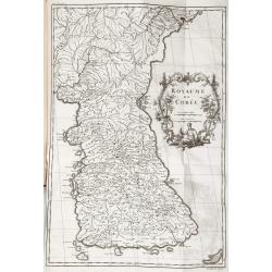
Royaume de Corée.
With a quite elaborately pictorial cartouche, engraved by G.Kondet. One of the earliest separate maps of Korea. Jean Baptiste Bourguignon d' Anville (1697-1782), French c...
Date: The Hague, 1737
![Province de Fo-Kien. [Includes West Coast of Taiwan]](/uploads/cache/43503-250x250.jpg)
Province de Fo-Kien. [Includes West Coast of Taiwan]
An important map of Fujian Province shows the East Coast of China and the West Coast of Taiwan. It shows that for the Manchu Qing, only the western half of Formosa was co...
Date: The Hague, H. Scheurleer, 1737

Avantures du Sr. C. Le Beau, avocat en parlement ou Voyage curieux et nouveau parmi les Sauvages de l'Amérique Septentrionale. Dans lequel on trouvera une Description du Canada… Ouvrage enrichi d'une Carte et des figures necessaires.
A description of Huron, Iroquois, and Algonquin customs, written in charming style and based, the Author claims, on observations made on a trip to America in 1729." ...
Date: Amsterdam, 1738
![(Chatelain "Atlas Historique" in 7 volumes.]](/uploads/cache/47053X-250x250.jpg)
(Chatelain "Atlas Historique" in 7 volumes.]
Henri Abraham Chatelain, whose Atlas Historique was one of the most expansive encyclopedias of the age. First published in 1705, Chatelain's Atlas Historique was part o...
Date: Amsterdam: Chez Zacharie Châtelain, 1732 - 1739
