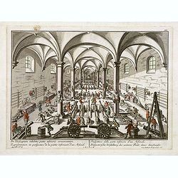
Featured Listings

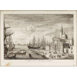
Bern in der Schweitz.
Very fine large-scale panoramic view of Bern. With a numbered key (1-25) of principal buildings in town. ¤
Date: Augsburg, 1740

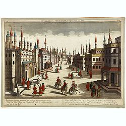
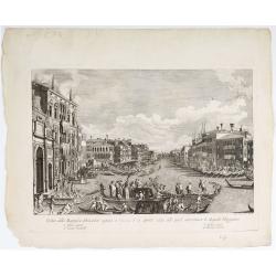
Paris.
A spectacular large-scale panoramic view of Paris, with legends numbered from 1-70 in French. With the title in a banderol.After a design by Friedrich Bernhard Werner (16...
Date: Augsburg, ca. 1740

Paris.
This is a spectacular panoramic view of Paris, with legends numbered from 1 to 70 in French. The title is in a banderol.After a design by Friedrich Bernhard Werner (1690-...
Date: Augsbourg, ca. 1740
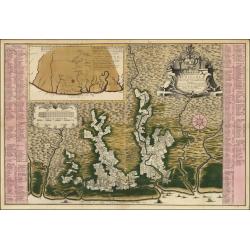
Algemeene kaart van de Colonie of Provintie van Suriname : met de rivieren, districten, ontdekkingen door militaire togten. . .
1740 DE LETH, H. - Large-scale map of Suriname, a record of one of the most important early Jewish communities in the Americas.
Date: Amsterdam, 1740
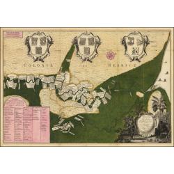
Naaukeurige Platte Grond van den Staat en den Loop van Rio de Berbice Met derzelver Plantagien in de Geoctrojeerde Colonie de Berbice Gelegen. . .
Uncommon large-scale map of Berbice with Rio de Berbice and Rio de Canje, with at the bottom left a list of plantation owners. In the top 3 x 3 coats of arms in cartouche...
Date: Amsterdam, 1740

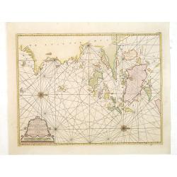
Carte particulière des environs de St Peters-bourg. . . / Plan de la ville faubourg et environs de St Petersbourg. . . / Carte pour l'intelligence de la guerre de Moscovie et de Suede. . .
A scarce and unusual plan of Saint Petersburg shown at a large scale and also, in a separate compartment, shown in its geographical context between the Gulf of Finland an...
Date: Paris, c.1741
Aedis Divi Rocchi facies rudis…
The Campo San Rocco. Title centred in the lower margin; “Mich. Marieschi del.t et inci.t” at the right corner of the cartouche. From the series "Magnificentiores Sel...
Date: Venice, c. 1742

Imperii Russici et Tartariae Universae tabula novissima.
Decorative and rare map covering Russia, Tibet, China, Tartary, Korea, Taiwan and Japan prepared by J. M. Hasius. The sea between Japan and Korea is mentioned Mare Orient...
Date: Utrecht, 1743
![[Manuscript chart on vellum of the Java Sea]](/uploads/cache/33613-250x250.jpg)
[Manuscript chart on vellum of the Java Sea]
One of the few manuscript charts on vellum in private hands, signed by Isaac de Graaf. ORIGINAL MANUSCRIPT MAP IN RED, GREEN AND BLACK INK showing the Java Sea centered o...
Date: Amsterdam, 1743

Allerneuester geographisch- und topographischer Schau-Platz von Africa und Ost-Indien. . .
An early issue of this important book by Johann Wolfgang Heydt's describing the Dutch factories, settlements and stations at the hands of the Dutch East India Company in ...
Date: Wilhermsdorf, Tetscher u. Nürnberg, Homanns Erben, 1744
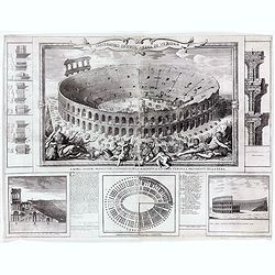
Anfiteatro detto l'Arena di Verona.
Large two sheet copper engraving of the Amphitheater of Verona after a design of Adriano Cristofali. On three sides it is surrounded by architectural details interspersed...
Date: Verona, 1744

Chaerte vande Wieringer waert, de welcke inden jaere XVI… (Wieringerwaard)
Rare wall map of the Wieringerwaard polder, as raffled on 12 July 1611. The polder was laid dry in 1610. It border, and the municipality's border, were the Zuiderzee, the...
Date: 1741-1744

Gustaaf Willem Baron van Imhoff.
Decorative portrait of Gustaaf Willem Baron van Imhoff, who was Governor for the V.O.C. (Dutch East Indian Company) in Indonesia.
Date: Amsterdam, 1745
![Carte de la coste orientale de la Chine depuis Amoy, jusqu'à Chusan avec une partie de l'Isle Formose [with] Plan du port d'Amoy ou Emouy.](/uploads/cache/33583-250x250.jpg)
Carte de la coste orientale de la Chine depuis Amoy, jusqu'à Chusan avec une partie de l'Isle Formose [with] Plan du port d'Amoy ou Emouy.
Important French chart of the China Sea with the coast of Northern China, including a large depiction of Formosa.Latitude and longitude scales, compass rose and system of...
Date: Paris, Jean-François Robustel, 1745

Nouvelle carte des mers comprises entre le détroit de Banca et P°. Timon avec la partie orientale du détroit de Malacca.
Important French chart of the tip of Malaysia with Singapore. Latitude and longitude scales, compass rose and system of rhumb lines, soundings near coast and in bay areas...
Date: Paris, 1745

Itinera Varia Auctoris.
From A Natural History of Uncommon Birds, and of some other rare and undescribed Animals, Quadrupeds, Reptiles, fishes, insects, &c.. The map shows Edwards' journeys ...
Date: London, 1746
![Kantong [The Dutch Folly Fort off Canton]](/uploads/cache/05714-250x250.jpg)
Kantong [The Dutch Folly Fort off Canton]
Charming 18th water color on paper depicting The Dutch "Folly Fort" off Canton. Probably made by a western artist visiting China.Forts were built in several pla...
Date: Canton?, c.1750
Per telecopium exhibitio partis inferioris armamentarii. / Representation en perspective de la partie inferieure d'un arsenal. . .
RARE. Engraved optical print by Georg Balthasar Probst of a arsenal.
Date: Augsburg, 1750

't Hooge Heemraedschap van Delfland met alle de Steden, Dorpen, Ambachten, Litmaten, Polders, (etc.).
The so-called Kruquius map is a wall-map of the Delfland water board district. The map consists of 25 engraved map sheets. Several maps flanked by fine large armorial car...
Date: Delft, 1712-1750

Vue de l Hotel du Lord Maire, qui comprend la Façade, et le Cot' Occidental de Londres.
Shows the famous Lord Mayor's coach driving through London. The Lord Mayor's coach is famous for its role in the Lord Mayor's Show, which is one of the longest-establishe...
Date: Augsburg, 1750
Prospectus septem turrium in urbe Constantinopolitana / Vüe des sept Tours ou Prisons d'etat à Constantinople. . .
Imaginary view inside Istanbul showing the State prison, the seven towers to Constantinople, a so-called optical print.
Date: Augsburg 1750
![[Set of 3 optical prints] Vue du Pallais du l'Empereur de Perse avec la Mosquée, ou Eglise a Ispahan.](/uploads/cache/49123-250x250.jpg)
[Set of 3 optical prints] Vue du Pallais du l'Empereur de Perse avec la Mosquée, ou Eglise a Ispahan.
An optical print of the court of the Persian Emperor. Engraved by F.X. Habermann (1721-1796). The Academie Imperiale was a well-known publisher of optical prints establis...
Date: Augsburg, 1750

Pas-Kaat vaneen gedeelte van de Aethiopische Zee behelsende de Kusten Zanguebar, Ajan en Abex, en een gedeelte van de Arabische Kust. . .
A finely engraved and detailed chart of the most eastern tip of Africa, including Somalia, Djibouti, Yemen, Mauritius, and many other islands in the Indian Ocean.Very rar...
Date: Amsterdam, 1753

A View of S. James's Palace Pall Mall. - Vues du Palais royal de S.Jacques Pall Mall.
So-called optical print illustrating a perspective view of St James's Palace, Pall Mall. The gatehouse of St James's Palace is on the left.In the eighteenth and nineteent...
Date: Paris, 1753
Paskaart van de Eijlanden Cheuxan Lowang en alle deselfs onderhoorige Eylande. . .
A rare and finely engraved and detailed chart of China's Zhejiang Province, including Ningbo, Zhoushan and Mount Putuo (Powto) and the mouth of the Yangtze Delta, just so...
Date: Amsterdam, 1753

Carolinae Floridae nec non Insularum Bahamensium cum partibus adjacentibus delinatio ad Exemplar Londinense in lucem edita . . . Ao. 1755.
The German edition of this map of Carolina, Florida, and the Bahama Islands in full original colors. Published in Seligmann's "Sammlung verschiedener auslaendischer ...
Date: Nuremberg, 1755

Vorstellung Einiger Gegenden und Plaetze in Nord-America unter Franzoesisch und Englische Jurisdiction Gehoerig zu Finden bey den Homaennischen Erben in Nurnberg Ao. 1756.
Three town plans on one sheet of eastern Canada, including Quebec, Louisbourg and Halifax towns which the English and French fought to conquer on the American continent f...
Date: Nuremberg, 1756

Carte des Possessions Françoises et Angloises dans le Canada, et partie de la Louisiane.
First state of this separately published map of the European Colonies in the New World east of the Mississippi River. This map was published in 1756 to provide informatio...
Date: Paris, 1756
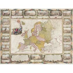
L'Europe divisée en tous ses états, dressée sur les nouveaux mémoires et suivant les dernières observations.
Rare wall map of the European continent, published by the Parisian publisher Sébastien G. Longchamp.The map is surrounded by a magnificent Rococo-style frame decorated wi...
Date: Paris, 1757

RESTORED CROSSTAFF SEGMENT
RESTORED CROSSTAFF SEGMENT, Dutch, 1757, signed “I*v*K” for Johannes van Keulen, dated “1757” and numbered “23.” The staff is made of ebony, 11/16” (18 mm) square in cro...
Date: Amsterdam, 1757

Belgica Foederata. . .
Decorated with a cartouche showing the coats of arms of Zeeland, Holland, Utrecht, Friesland, Groningen and Overijssel. T.C. Lotter married M. Seutter's daughter in 1740 ...
Date: Augsburg, ca.1760
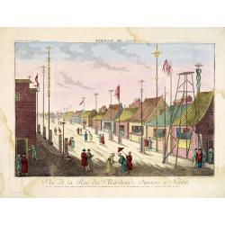
Vue de la Rue des Marchands Chinoises a Nankin.
1760 - OPTICAL PRINT - Illustrating a street in 18th-century Nanjing, one of China’s most important historic capitals.
Date: Augsburg, 1760

Karte von den Kusten von Arabien . . .
Manuscript map of Arabia. A close copy of Bellin's map of the Arabian Peninsula. In the lower right margin "Tom A, vol V."A title cartouche in the lower left co...
Date: Germany, ca. 1760

Pianta Geografia delle Isole di Malta, e Gozo della Sagra Religione Gerosolimitana di S. Giovanni delineata, ed incisa in quest anno 1761.
A rare map of Malta and Gozo printed by the priest Antonio Bova (1688 - 1775), who was active as engraver in Palermo ca. 1727-1773. He produced cartographic engravings, s...
Date: Bova Ant., Palermo, 1761

Plan du Port de St Augustin dans la Floride.
This chart shows a plan of the Port of St. Augustine in Florida.The only issue of this version of Bellin's map, slightly larger than the common version. Depths shown by s...
Date: Paris, 1764

Carta Topografica dell' Isola Del Maritaggio di Monsieur le Boble per la prima volta. Tradotta dal francese in italiano.
Second Italian printing of Eustache Le Noble’s "Carte de l’isle de marriage." The book’s text offers instructions on how to reach this matrimonial island and de...
Date: Cosmopoli, 1766

America settentrionale. . .
Rare map of North America drawn directly from the work of Nicholas De Fer and N. Sanson's famous map of 1650. The map is engraved by Antonius Donzel Gallus.With open Grea...
Date: Napels, 1766
![The Coast of New Found Land From Salmon Cove to Cape Bonavista. . . [together with] The Coast of New Found Land from Cape-Raze to Cape St-Francis.](/uploads/cache/40658-250x250.jpg)
The Coast of New Found Land From Salmon Cove to Cape Bonavista. . . [together with] The Coast of New Found Land from Cape-Raze to Cape St-Francis.
Two charts showing the coast of New Found Land from Salmon Cove to Cape Bonavista and from Cape-Raze to Cape St-Francis. With inset chart of Trinity HarborGrierson publis...
Date: Dublin, 1767

The Harbour of Casco Bay and Islands Adjacent Bt Capt. Cyprian Southicke.
The earliest printed chart of Casco Bay, an inlet of the Gulf of Maine on the southern coast of Maine, New England. First issued in 1720 by Mount and Page, it remained in...
Date: Dublin, 1767

Nouveau théâtre de la guerre entre les Russes les turcs et les polonois confédérés.
A very rare separately published map of Crime region. With a large title cartouche lower left "Nouveau theâtre de la guerre entre les russes, les turcs et les polono...
Date: Paris, 1769

Nieuwe kaart van Kanada . . .
Nice map of the Bay of Hudson, In Labrador, a small inset of Nova Scotia. The map is dated 1769. All text is in Dutch. The map shows the region shortly after the conclusi...
Date: Amsterdam, 1769
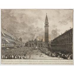
Habita a Serenissimo Duce in Basilica D.Marci ad populum allocutione…
Habita a Serenissimo Duce in Basilica D.Marci ad populum allocutione, ab eoque Dux salutatus, Armamentariorum humeris in sella gestatoria cum duobus proxime consanguineis...
Date: Venice, c. 1766-1770
![Vue de la Rivière d'Endeavour sur la Côte de la Nouvelle Hollande ou le Vaisseau fut mis à la bande. [Tome IV Pl. 1ère.]](/uploads/cache/26093-250x250.jpg)
Vue de la Rivière d'Endeavour sur la Côte de la Nouvelle Hollande ou le Vaisseau fut mis à la bande. [Tome IV Pl. 1ère.]
The first known landscape drawing of the east coast of Australia. A View of the Endeavour River, on the coast of New Holland, where the ship was laid on shore, in order t...
Date: Paris, 1773

Terrae Yemen Maxima Pars, seu Imperii Imami, Principatus Kaukeban nec non ditionum Haschid u Bekil, Nehhm, Chaulan, Abu Arisch et Aden Tabula ...
South-west Arabia, with the Saudi Arabian city of Jizan south to Aden. With a fine title, cartouche. Based on a map by Carsten Niebuhr. With the name Sinus Arabicus Mare ...
Date: Augsbourg, 1774
![Cession de l'Isle d'Ohahiti au Capitaine Wallis par la Reine Obéréa. [Tome II Pl. 2.]](/uploads/cache/26111-250x250.jpg)
Cession de l'Isle d'Ohahiti au Capitaine Wallis par la Reine Obéréa. [Tome II Pl. 2.]
Queen Oberea's transfer ceremony to Captain Wallis on Tahiti.Engraved by François Godefroi. From the French edition of James Cook's first voyage entitled Relation des voy...
Date: Paris, 1774
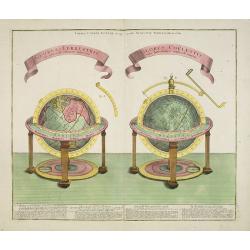
GLOBUS TERRESTRIS ad sphaeram obliquam delineatus. and the GLOBUS COELESTIS cum Astrodictico artificiali iunctus.
A very handsome, large copper engraving of a pair of globes. Ribbon style titles and German text panel at bottom.
Date: Augsburg, 1774

A chart of the China Sea inscribed to Monsr. D'APRES de MANNEVILLETTE .. To A.Dalrymple.
This most important milestone chart is based upon the surveys made from navigational surveys by Alexander Dalrymple (1737-1808]. He was the first hydrographer of the Brit...
Date: Paris, ca 1775
![Planisphere celeste Septentrional. . . [together with] Planisphere celeste meridional. . .](/uploads/cache/35291-250x250.jpg)
Planisphere celeste Septentrional. . . [together with] Planisphere celeste meridional. . .
Beautiful set of celestial charts of the northern and southern skies by the well-known French astronomer, Philippe de La Hire. Surrounded by panels of astronomical notes ...
Date: Paris, ca.1775

A Map of the most Inhabited part of New England containing the Provinces of Massachusetts Bay and New Hampshire, with the Colonies of Connecticut and Rhode Island.
A copper engraving in four sheets, published in Georges Louis Le Rouge, in his "Atlas Ameriqua in Septentrional Contenant les details des differentes provinces, de c...
Date: Paris, 1777

La Pologne Dressée sur ce qu'en ot donné Starovolsk, Beauplan, Hartnoch. . .
Large map of Poland, Lithuania, Belarus and part of Ukraine. The map is filled with detail and decorated with a title cartouche flanked by mythological figures.According ...
Date: Paris, 1773 - 1780
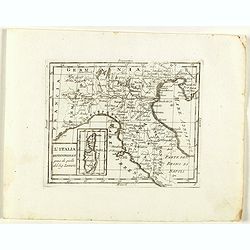
L'Italia Settentrionale presa da quella del Sig. Zannoni.
Rare map of Italy with inset map with Corsica and Sardinia, from "Atlante Novissimo ad uso Dei Giovani Studiosi Contenuto In Carte XXVII.", published by Giovann...
Date: Rome, 1780
![[No title.] Sixteen small engravings.](/uploads/cache/46799-250x250.jpg)
[No title.] Sixteen small engravings.
A nice set of sixteen French professions, or trades, or stage characters. The print is faint on some titles. Some of the characters are a soldier, a doctor, a nun, a lawy...
Date: Paris, ca. 1780
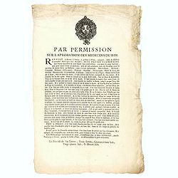
Par permission sur l'aprobation des médecins du roi...la véritable Boule de Mars...
Printed broadsheet promoting the "Boule de Mars" (March Ball) produced and sold by Renault in Nancy and Paris. Ornated with the royal coat of arms of France. Pr...
Date: Paris, ca.. 1780

Connecticut and Parts adjacent at Amsterdam. .
A nice example of this early map of the state of Connecticut, with part of Rhode Island to the east, Long Island to the south, and New York to the east. Rivers, roads, to...
Date: Amsterdam, 1780
![[Lot of 4 charts] Plan de la Baie et du Port de Camraigne / Plan de la Baie de Niatrang et du Golfe de Binkang / Plan de la Cote de Cochinchine. . . / Plan des Ports de Xuandai, Vung-Lam. . .](/uploads/cache/44795A-250x250.jpg)
[Lot of 4 charts] Plan de la Baie et du Port de Camraigne / Plan de la Baie de Niatrang et du Golfe de Binkang / Plan de la Cote de Cochinchine. . . / Plan des Ports de Xuandai, Vung-Lam. . .
[A set of four French sea charts numbered consecutively]. A set of 4 basic coastal sea charts of parts of southern French Indochina (Vietnam).Chart 295 centers on the reg...
Date: Paris ca 1780
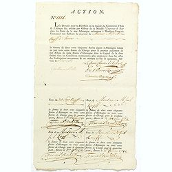
ACTION N° 1155. Société du Commerce d'Asie & d'Afrique.
Share of 1 000 Florins d'Allemagne (1 000 Guilder) of the "Triester Handelsgesellschaft" (Société du Commerce d'Asie & d'Afrique) signed by duke Charles de ...
Date: Triest / Antwerpen, 1 October 1781
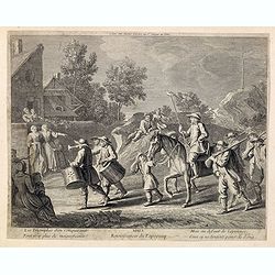
MARS Rejouissances du Papeguay. Les Triomphes d'un conquerant
Etching published by Louis Charles Desnos (1725-1805) with address of rue St.Jacques au Globe. He is also known for his output of wall maps and atlases.
Date: Paris, 1782
Russian Empire in Europe from the Dr. D'Anville of the Royal Academy. . .
Rare map of Russia, prepared by John Bayly (active 1755-1794) after D'Anville. In the lower-left corner parts of the Caspian and Black Sea. In the upper right corner Nova...
Date: London, ca. 1782

Nouvelle Mappa Monde.
State 2 of this fine double hemisphere world map, from an unusual perspective, with a "Mer de L'Ouest" or "Sea of the West". Paris is located at the c...
Date: Venice, 1776 - 1784

Carte D'Amerique Divisée en ses Principaux Pays. . .
Rare. Uncommon and decorative wall map of America, prepared by Clouet. With superb decorative borders, 170mm wide at the sides and 150mm at the bottom, containing twenty ...
Date: Paris, Cadiz, 1785

ETATS-UNIS DE L'AMÉRIQUE SEPTENTRIONALE Avec LES ISLES ROYALE, DE TERRE NEUVE, DE S.T JEAN, L'ACADIE, &c. 1785. Supplement a l'Atlas de M. Robert de Vaugondy a Paris Ches Boudet Ingenieur du Roi.
A map of the eastern United States with "Supplément à l'atlas de M. Robert de Vaugondy à Paris chez Boudet Imprimeur du Roi", in place of the attribution to Del...
Date: Paris, 1785
![[Crimea]. Carte de la Cromée.](/uploads/cache/25719-250x250.jpg)
[Crimea]. Carte de la Cromée.
Mapmaker, Captain Jan Hendrik van Kinsbergen (1735-1819). Published by H. Friesman in 1787. This map first appeared in 1776 and was the first Russian map of the newly ann...
Date: Amsterdam, H. Frieseman, 1787

Calendrier de la cour, tiré des éphémérides, pour l'Année bissextile.. / Notebook bearing silver plates with the VOC monogram.
A personal gift, only made for the trustees of the V.O.C. The silver plate was probably made by Drick van Hengel and Company because an entry in the diary of mintmaster J...
Date: Paris, 1787

Tableau des guerres de Frédéric le Grand: ou plans figurés de vingt-six batailles rangées, ou combats essentiels donnés dans les trois guerres de Silésie. . .
The book includes a large folded map "Tableaux des Guerres de Frédéric le Grand", showing a map of Prussia, with present-day Poland and Eastern Germany surround...
Date: Potzdam, Strasbourg, Paris, 1788
![[Manuscript] Plan du siege de la forteresse d'Oczakow avec les détails... aux ordres du Prince Potemkin, le 17 Decemb: 1788.](/uploads/cache/34599-250x250.jpg)
[Manuscript] Plan du siege de la forteresse d'Oczakow avec les détails... aux ordres du Prince Potemkin, le 17 Decemb: 1788.
Very detailed well executed manuscript plan of the Turkish Fortress Ochakov captured by Russian Troops on December 17, 1788 by the Maréchal Prince Potemkin. In lower left...
Date: ca. 1788

Map of Louisiana from D'Anville's Atlas.
This map presents a highly detailed treatment of the region from Cabo Del Norte to the Apalachiola River, centered on the mouth of the Mississippi and extending inland to...
Date: London, 1788

Carte d'Europe divisée en ses Empires et Royaumes.
Uncommon and decorative wall map of Europe, prepared by Clouet. Superb decoration including a wonderful rococo border with vignettes describing historical scenes. Below t...
Date: Paris, Mondhare, 1788
![CH'ONHA CHIDO [Atlas of all under Heaven]](/uploads/cache/33625-250x250.jpg)
CH'ONHA CHIDO [Atlas of all under Heaven]
The Ch’onha chido [Atlas of all under Heaven] is a late 18th century copy of the traditional Korean atlas produced in the early Choson dynasty (1392-1910). One of the map...
Date: Korea, ca. 1790
![[Tableau Général de l'Empire Ottoman]. 11 plates with the panoramic view of Mecca.](/uploads/cache/41513-250x250.jpg)
[Tableau Général de l'Empire Ottoman]. 11 plates with the panoramic view of Mecca.
A collection of 11 engraved plates (3 folding) from "Tableau Général de l'Empire Ottoman", Paris, Imprimerie de Monsieur, 1790, comprising the famous panoramic ...
Date: Paris, 1790
![ИНДIИ [Map of India in Cyrillic].](/uploads/cache/44340-250x250.jpg)
ИНДIИ [Map of India in Cyrillic].
A map of India. This Cyrillic version of the map appeared in one of the first world atlases published in Russia, "Novy Atlas, ili sobranie kart ..." which trans...
Date: Paris / St.Petersburg, ca. 1790

Dutchman and a Maruyama prostitute.
An explicit scene of a Dutchman and a Maruyama prostitute featuring a gray-bearded westerner coupling with a courtesan. The woman protests that she doesn't understand wha...
Date: Late Edo, 1790
S. Georgii Majoris Ecclesiae prospectus.
S. Georgii Majoris Ecclesiae prospectus". S. Giorgio with the church and quay in sharp perspective.From the series "Prospectum Urbis Venetiarum" (Views of ...
Date: Venice, ca. 1791
Veduta della Magnifica REGATA seguita in Venezia li 2. Aprile 1791 alla quale intervennero li Augusti Viaggiator.
Decorative engraving of a Venice regatta on the Grand Canal, by Teodoro Viero (1740-1819) after a paining by Canaletto.The tradition of Venetian origin of the race is lin...
Date: Venice, c. 1791
![[ LANDSKROON ]. Oranda Fune no zu [= Depiction of a Dutch Ship].](/uploads/cache/28003-250x250.jpg)
[ LANDSKROON ]. Oranda Fune no zu [= Depiction of a Dutch Ship].
A very large and extremely detailed Japanese drawing on rice paper of a Dutch ship at the artificial island Deshima, the VOC's outpost in Nagasaki harbour. In the drawing...
Date: Japan, Kansei 4, 2nd month, 9th day, 30 March? 1792

Mapa De la parte de la Isla Formosa sa perteneciente al Emperadotde la China sacado por Ord. De S.M.
Extremely rare map of the west coast of Taiwan, the Punghu or Pescadore Islands, and the Fokien or Fujian coast of China. Several ancient Taiwanese cities are noted, incl...
Date: Manilla, Seminario Conciliar, y Real de San Carlos, 1788-1792

Bison Iubatus.
Etching of a bison by Leendert Brasser (1727 - 1793) after a painting of the Dutch artist Gerrit van den Heuvel.An early portrait of a bison, etched by Leendert Brasser (...
Date: Rotterdam, 1766-1793

Imperium Russicum, cum regionibus adiacentibus duabus Tabulis ex optima quae A. 1784 tribus foliis comparavit Mappa geographica, aliisque subsidiis delineatum a C. Mannert, Tabula Ima. . .
A detailed map of the European part of the Russian Empire. Scarce map. Copper etching by C. Mannert and edited by Adam Gottlieb Schneider and Johann Christoph Weigel. Man...
Date: Nuremberg, 1794
Passeport.
Passport for the United States in the name of Madeleine Lavit Femme Lory, issued by the Commission of Interior Relations and approved by the Committee of Public Safety.Th...
Date: Paris, 1795
A Plan of the city and harbour of Macao : a colony of the Portugueze, situated at the southern extremity of the Chinese Empire. . .
A large chart of Macao engraved by Benjamin Baker (fl. 1766-1824) and published by George Nicol. The town of Macao is shown in detail, with a 37-point key in English list...
Date: London, 1796

New Jersey entworfen von D.F. Sotzmann. Hamburg bey Carl Ernst Bohn 1796 . . . NO.VIII
Extremely rare map of New Hampshire prepared by Daniel Friedrich Sotzmann for Christopher Ebeling's "Erdbeschreibung von Amerika", a project ended after only te...
Date: Hamburg, Carl Ernst Bohn, 1797
