Sign In or Sign Up
A new and correct map of the world. |
||||||||||||||||||||
|
||||||||||||||||||||
|
|
||||||||||||||||||||
$12000 / ≈ €10491This item is available for immediate sale! Questions before Buying ?
We are happy to answer your questions.
12000.00
|
My Collection +
Add this or any of your favorite items in one place. If you want to save the items permanently, you have to sign in or create an account first. |
|||||||||||||||||||
Description
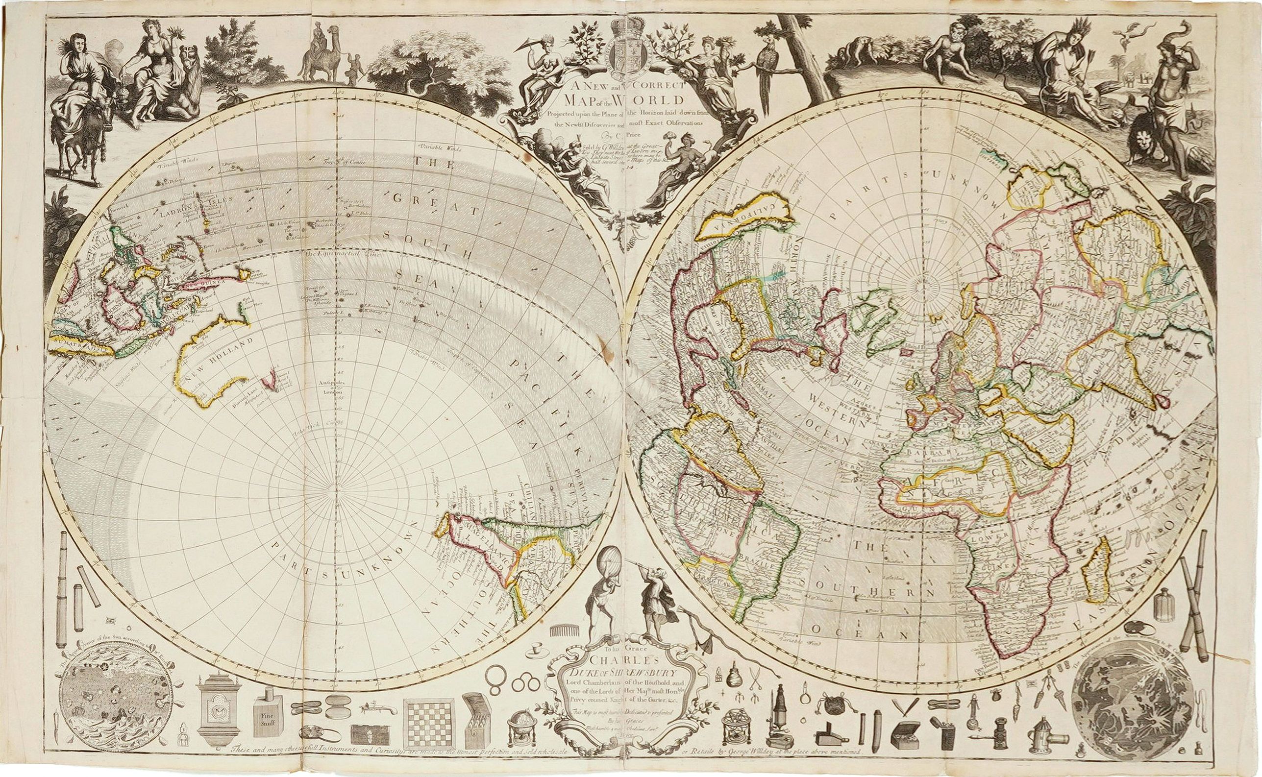
The early eighteenth century was one of the most important periods for English cartography. One of the period's most intriguing world maps is this large-scale map, which offered the latest geographical discoveries and an assortment of toys, instruments, and curiosities made and sold at the publishers' shop. The map is oriented with London at the center of the Eastern Hemisphere and its antipode at the center of the Western Hemisphere.
California is depicted as an island and, as usual, the coasts of
Australia and New Zealand are incomplete, including ocean currents.
With advertisement on map: "These and many other useful Instruments and curiosities are made to the utmost perfection and sold wholesale and retail by George Willdey at the place above mentioned" .
The map is dedicated "To his Grace Charles Duke of Shrewsbury Lord Chamberlain of the Household, and one of the Lord of Her Majesty's most Honble Privy Council Knight of the Garter, &c."
The borders are filled with globes, telescopes, clocks, fine snuff boxes, microscopes, glasses, etc. In the lower left corner is the sun's appearance, according to Mr.Kircher, and in the lower right is the moon, according to Cassini. At the top, the four continents are depicted allegorically, with examples of their animal life and inhabitants.
Charles Price was a publisher, draughtsman, surveyor and globemaker active in London and associated with Willdey 1711-1714.
Willdey was a spectacle maker who went on to become the most noted toymaker of Europe.
He lured mapmaker Charles Price from his rival map publisher, John Senex. Price (flourished 1680-1720) was probably the best cartographer in England, and under George Wildey's direction, he continued issuing the series of two-sheet maps that Senex had started.
This is the second state of the copperplate, with the prior state dated 1713. The map would later be sold to Thomas Jefferys, who would reissue it without the advertising at the bottom.
Reference: Campbell, Early maps, p.68.
With advertisement on map: "These and many other useful Instruments and curiosities are made to the utmost perfection and sold wholesale and retail by George Willdey at the place above mentioned" .
The map is dedicated "To his Grace Charles Duke of Shrewsbury Lord Chamberlain of the Household, and one of the Lord of Her Majesty's most Honble Privy Council Knight of the Garter, &c."
The borders are filled with globes, telescopes, clocks, fine snuff boxes, microscopes, glasses, etc. In the lower left corner is the sun's appearance, according to Mr.Kircher, and in the lower right is the moon, according to Cassini. At the top, the four continents are depicted allegorically, with examples of their animal life and inhabitants.
Willdey was a spectacle maker who went on to become the most noted toymaker of Europe.
He lured mapmaker Charles Price from his rival map publisher, John Senex. Price (flourished 1680-1720) was probably the best cartographer in England, and under George Wildey's direction, he continued issuing the series of two-sheet maps that Senex had started.
This is the second state of the copperplate, with the prior state dated 1713. The map would later be sold to Thomas Jefferys, who would reissue it without the advertising at the bottom.
FAQ - Guarantee - Shipping
Buying in the BuyNow Gallery
This item is available for immediate purchase when a "Add to Cart" or "Inquire Now" button is shown.
Items are sold in the EU margin scheme
Payments are accepted in Euros or US Dollars.
Authenticity Guarantee
 We provide professional descriptions, condition report (based on 45 years experience in the map business)
Paulus Swaen warrants the authenticity of our items and a certificate of authenticity is provided for each acquired lot.
Condition and Coloring
We indicate the condition of each item and use our unnique HiBCoR grading system in which four key items determine a map's value: Historical Importance, Beauty, Condition/Coloring and Rarity.
Color Key
We offer many maps in their original black and white condition. We do not systematically color-up maps to make them more sellable to the general public or buyer.
Copper engraved or wood block maps are always hand colored. Maps were initially colored for aesthetic reasons and to improve readability. Nowadays, it is becoming a challenge to find maps in their original colors and are therefor more valuable.
We use the following color keys in our catalog:
Original colors; mean that the colors have been applied around the time the map was issued.
Original o/l colors; means the map has only the borders colored at the time of publication.
Colored; If the colors are applied recently or at the end of the 20th century.
Read more about coloring of maps [+]
Shipping fee
A flat shipping fee of $ 30 is added to each shipment by DHL within Europe and North America. This covers : International Priority shipping, Packing and Insurance (up to the invoice amount).
Shipments to Asia are $ 40 and rest of the world $50
We charge only one shipping fee when you have been successful on multiple items or when you want to combine gallery and auction purchases.
Read more about invoicing and shipping
FAQ
Please have a look for more information about buying in the BuyNow gallery
Many answers are likely to find in the general help section.
My Collection+
![]()
With My Collection+ you can collect all your favorite items in one place. It is free, and anyone can create his or her virtual collection.
Unless you are logged in, the item is only saved for this session. You have to be registed and logged-in if you want to save this item permanently to My Collection+.
Read More[+]
Register here, it is free and you do not need a credit card.
Add this item to
My Collection+
or click the following link to see My Collection+.
| Digital Image Download | |
|
Paulus Swaen maintains an archive of most of our high-resolution rare maps, prints, posters and medieval manuscript scans. We make them freely available for download and study. Read more about free image download |
Click the image for a free small image download. |
In accordance with the EU Consumer Rights Directive and habitually reside in the European Union you have the right to cancel the contract for the purchase of a lot, without giving any reason.
The cancellation period will expire 14 calendar days from the day after the date on which you or a third party (other than the carrier and indicated by you) acquires, physical possession of the lot. To exercise the right to cancel you must inform Paulus Swaen Inc, of your decision to cancel this contract by a clear statement (e.g. a letter sent by post, or e-mail.
To meet the cancellation deadline, it is sufficient for you to send your communication concerning your exercise of the right to cancel before the cancellation period has expired.
Recently Viewed

A new and correct map of the world.
The early eighteenth century was one of the most important periods for English cartography. One of the period's most intriguing world maps is this large-scale map, which ...
Date: London 1714
