Featured Listings in Australia & Oceania

Paskaerte Zynde t'Oosterdeel Van Oost Indien, met alle de Eylanden daer ontrendt geleegen van C. Comorin tota aen Iapan.
1669 Pieter Goos ' eye-catching chart of Australia, Southeast Asia, China, Japan, Korea, and India. (With gold highlights.)
Date: Amsterdam, 1669
![Vue de la Rivière d'Endeavour sur la Côte de la Nouvelle Hollande ou le Vaisseau fut mis à la bande. [Tome IV Pl. 1ère.]](/uploads/cache/26093-250x250.jpg)
Vue de la Rivière d'Endeavour sur la Côte de la Nouvelle Hollande ou le Vaisseau fut mis à la bande. [Tome IV Pl. 1ère.]
The first known landscape drawing of the east coast of Australia. A View of the Endeavour River, on the coast of New Holland, where the ship was laid on shore, in order t...
Date: Paris, 1773
![Cession de l'Isle d'Ohahiti au Capitaine Wallis par la Reine Obéréa. [Tome II Pl. 2.]](/uploads/cache/26111-250x250.jpg)
Cession de l'Isle d'Ohahiti au Capitaine Wallis par la Reine Obéréa. [Tome II Pl. 2.]
Queen Oberea's transfer ceremony to Captain Wallis on Tahiti.Engraved by François Godefroi. From the French edition of James Cook's first voyage entitled Relation des voy...
Date: Paris, 1774

La nuova Zelanda delineate sulle ultima osservazioni del Capitan Cook.
First edition on laid paper Cassini’s splendid early map of New Zealand, being the most decorative version of Captain Cook's map of New Zealand, published in the very sca...
Date: Rome, 1798

La Nuova Olanda e La Nuova Guinea delineate sulle ultima osservazioni.
Cassini’s splendid and rare map of Australia and New Guinea, from the 'Nuovo Atlante Geografico Universale'. The emphasis of the map is the charting of Captain Cook down ...
Date: Rome, 1798
![Le Isole di Sandwich delineate sulle osservazioni del Cap Cook. [Hawaii]](/uploads/cache/43195-250x250.jpg)
Le Isole di Sandwich delineate sulle osservazioni del Cap Cook. [Hawaii]
FIRST EDITION on laid paper. Cassini’s splendid map depicts the Sandwich Islands, the old name for the Hawaiian Islands, at the end of the eighteenth century. The splendi...
Date: Rome, 1798

Botanibay, Englischer Verweisungs Ort fur Verbrecher. / Laijene Franzosicher Verweisungs Ort fur Verbrecher.
Copper engraving with four scenes and one portrait of Frederick III of Saxony on one sheet. In the upper part fanciful views of Botany Bay with English and French settlem...
Date: Zittau, 1798-1800

Kaart Van Nieuw Zeeland in de Jaaren 1769 en 1770 bezogt door den Luitenant J. Cook met het Schip De Endeavour.
A uncommon issue of this key map of New Zealand from the Dutch edition of Cook's map of New Zealand, published in 'Reize rondom de Waereld door James Cook', a Dutch editi...
Date: Leyden, Amsterdam & The Hague: Honcoop, Allart & van Cleef, 1795-1801
![Boats of the Friendly Islands. [together with] A Sailing Canoe of Otaheite.](/uploads/cache/30041-250x250.jpg)
Boats of the Friendly Islands. [together with] A Sailing Canoe of Otaheite.
Early view of Queen charlotte's sound, taken from "Views in the South Seas" being a very important and early views depicting scenes encountered while employed a...
Date: London, Boydell and Co., 1808
![Nouvelle-Hollande: Terre dEndracht - Cabane des naturels de la Presqu'Ile de Péron. [plate XXIV]](/uploads/cache/46346-250x250.jpg)
Nouvelle-Hollande: Terre dEndracht - Cabane des naturels de la Presqu'Ile de Péron. [plate XXIV]
An aboriginal camp fire, after the original sketches by Lesueur, from Voyage de découvertes aux terres Australes by François Péron, 1824.The French expedition under Nicol...
Date: Paris, 1824
![[Portraits. Friendly Islands ].](/uploads/cache/26385-250x250.jpg)
[Portraits. Friendly Islands ].
Aquatint depicting inhabitants of the Friendly Islands. Plate N°79. From Giulio Ferrario's work Le Costume Ancien et Moderne ou Histoire du gouvernement, de la milice, de...
Date: Milan, 1827

Carte des Iles Hawaii.
A lovely small map of the complete chain of Pacific islands known today as the Hawaiian islands, from Dumont d'Urville's atlas "Voyage pittoresque autour du Monde.&q...
Date: Paris, 1834

Océanie.
A very decorative 19th century map of the Pacific Ocean, with hand colored lines indicating the extent of Polynesia, Micronesia, Melanesia, and Malaysia (or Southeast Asi...
Date: Paris, 1850

Océanie.
A very decorative 19th century map of the Pacific Ocean, with hand colored lines indicating the extent of Polynesia, Mirconesia, Melanesia, and Malaysia (or Southeast Asi...
Date: Paris, 1850
Selling price: ????
Please login to see price!
Sold in 2025

Australia.
Decorative steel engraved map of Australia, surrounded by illustrations of Sydney harbor, birds, kangaroos and local people. Interlocking border design. Taken from "...
Date: London, ca. 1851

(The City And Harbour Of Sydney From Near Vaucluse.)
One of the most sought after views of the city and harbour of Sydney seen from Near Vaucluse, 1852. Magnificent hand-colored tinted lithograph and finished by gum-Arabic....
Date: London, J. Hogarth, 1852
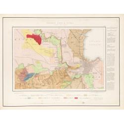
Geological Survey of Victoria.
The portfolio with the gold stamped title "Geological Survey of Victoria", contains 51 sheets maps. There is a pocket attached to the inside front cover contain...
Date: Mining and Geological Department, Melbourne, ca. 1864
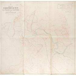
Map of contour survey of the site for the federal capital of Australia.
Map of contour survey of the site for the federal capital of Australia / drawn on stone by Messrs. O. Fischer and A.G. von Stach under direction of E.S. Vautin ; drawn on...
Date: Department of Lands, Sydney, 1910
![[Lot of 2 maps] Map of part of New South Wales Australia shewing position of Commonwealth Territory / Map of New South Wales Australia…](/uploads/cache/49457-250x250.jpg)
[Lot of 2 maps] Map of part of New South Wales Australia shewing position of Commonwealth Territory / Map of New South Wales Australia…
Two maps depicting the region of New South Wales and the area designated as the future Commonwealth Territory (which later became the Australian Capital Territory).The fi...
Date: Department of Lands, Sydney NSW, 1911

Histoire Socialiste.
Text includes “Imp. Centre de Propagande, des Républicains Nationaux, 102, rue Amelot, Paris (XIe), ou l’on peut se procurer cette affiche. Cette affiche ne peut être pla...
Date: Paris, 1931
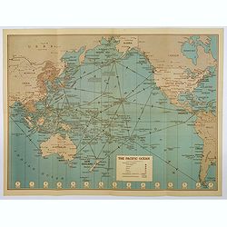
Hammond's War Map.
Drawn and published in early 1942 by C. S. Hammond & Co. in direct response to the bombing of Pearl Harbour, this is one of the most detailed USA maps of the Pacific ...
Date: New York, 1943
