Browse Listings in Europe > Russia / Baltic / Black Sea region
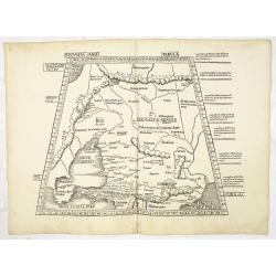
Secunda Asiae Tabula (Ukraine and Russia)
Woodblock printed a large-format Ptolemaic map showing Russia, Ukraine, and the Black Sea region. From the 1513 edition of Waldseemüller's Geographia.One of the earliest...
Date: Strasburg, 1513
![Tabula III Asiae. [Caucasus and Armenia.]](/uploads/cache/47571-250x250.jpg)
Tabula III Asiae. [Caucasus and Armenia.]
Ptolemaic map of the region south of the Caucasus Mountains and between the Caspian Sea as far south as the headwaters of the Tigris River in the south and the Black Sea,...
- $750 / ≈ €655
Date: Lyons, M. Servetus, 1525
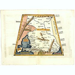
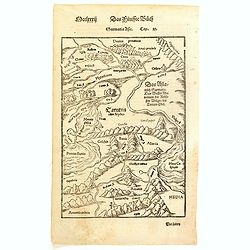
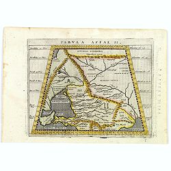
Tabula II Asiae.
A striking example of this wood-cut map depicts north of the Black Sea and west of the Caspian Sea (Ukraine, Russia, Georgia and Armenia). Ptolemy collected his data arou...
- $550 / ≈ €480
Date: Lyons, 1535
![.[Georgia (Republic), Sarmatia, Ukraine]](/uploads/cache/33870-250x250.jpg)
.[Georgia (Republic), Sarmatia, Ukraine]
Wood block printed map and one of earliest printed representation of Georgia (Republic), Sarmatia, Ukraine prepared by Martin Waldseemüller. Based on the slightly larger...
Date: Vienna, Trechsel, G., 1525 -1541
![[Europe, Eastern, Sarmatia, Ukraine]](/uploads/cache/33854-250x250.jpg)
[Europe, Eastern, Sarmatia, Ukraine]
Wood block printed map and one of the earliest printed representations of European Sarmatia, generally the region between the Baltic and Black Sea and Sea of Azov. Includ...
Date: Vienna, Trechsel, G., 1525 -1541
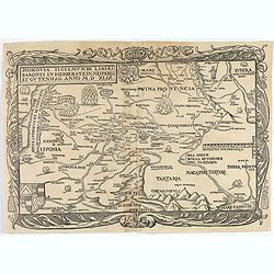
Tabula Asiae II (Black Sea and Caspian Sea).
The first edition of Münster's map of Ukraine and the region north of the Black Sea, based upon Claudius Ptolemy which appeared in his "Geographia Universalis"...
- $400 / ≈ €349
Date: Basel, Heinrich Petri, 1545
Tabula Asiae II (Black Sea and Caspian Sea)
The first edition of Munster's map of Ukraine and the region north of the Black Sea, based upon Claudius Ptolemy which appeared in his "Geographia Universalis",...
- $500 / ≈ €436
Date: Basel, Heinrich Petri, 1545
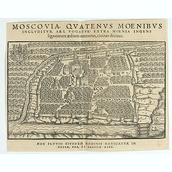
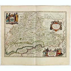
Moscovia Sigismundi Liberi Baronis In Herberstein, Neiperg et Gutehnag Anno M.D XLIX
The forst modern plan of Moscow. A rare and important cornerstone map for Russia collections.Sigismund von Herberstein made two visits to Russia. In 1517-18 he travelled ...
Date: Vienna, 1549
Moscovia Sigismundi Liberi Baronis In Herberstein, Neiperg et Gutehnag Anno M.D XLIX
First Modern Map of Russia. A rare and important cornerstone map for Russia collections.Sigismund von Herberstein made two visits to Russia. In 1517-18 he travelled as a ...
Date: Vienna, 1549
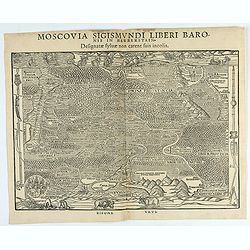
Moscovia Sigismundi Liberi Baronis In Herberstein, Neiperg et Gutehnag Anno M.D XLIX
First Modern Map of Russia. A rare and important cornerstone map for any Russian collection.One of two maps of Russia compiled by Herberstein, who was ambassador from the...
Date: Basle, 1556
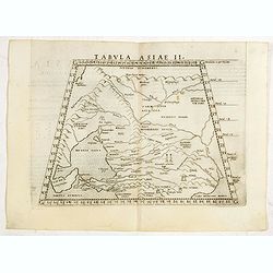
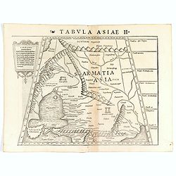
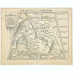
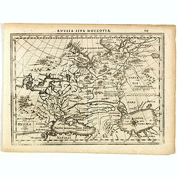
Tabula Asiae II.
Scarce FIRST edition of this map of the ancient region of Asiatic Sarmatia - now Southern Russia and part of Ukraine, around the Azov seaGirolamo Ruscelli's edition of Pt...
- $300 / ≈ €262
Date: Venice, 1561
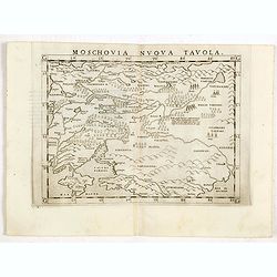
Moschovia nuova tavola.
Scarce FIRST edition of this map centered on Moscow. In the lower left Crimea and the Sea of Azov. The map is filled with small tents to represent Tartar camps.Girolamo R...
- $300 / ≈ €262
Date: Venice, 1561
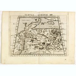
Tabula Europae IIII.
The scarce FIRST edition of this classical map depicting Northern Europe, Denmark and the Baltic. Includes engravings of a number of interesting animals in the right-hand...
- $450 / ≈ €393
Date: Venice, 1561
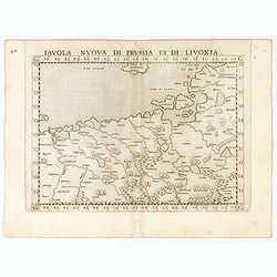
Tavola nuova di Prussia et di Livonia.
Uncommon first edition of this early map of the region from Pomerania to Livonia, includes a portion of Estonia, and coastal detail on the Baltic Sea with a small section...
Date: Venice, Vincenzo Valgrisi, 1561
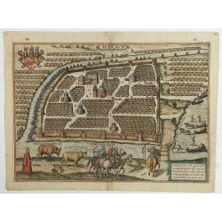
Moscavw. Moscovia, Urbs regionis eiusde nominis metropolitica, duplo maior. . .
Showing Moscow within the walled city and figures in the foreground. Title cartouche in the lower right corner Moscovia, Urbs. Regionis ciusde nominis metropolitica, dup...
Date: Cologne, 1580
Sarmatia Asie.
The map is showing the area of Armenia and Kazakhstan. From his Cosmographia, that great compendium of Renaissance knowledge. Sebastian Münster was born in Nierder-Ingel...
- $90 / ≈ €79
Date: Basle, 1550-1580
The Best Ptolemaic Map of Germany: Europ. IIII. Tab.
An elegantly engraved map of Germany as it was known in the Roman Imperial Period from Mercator’s definitive edition of Ptolemy’s geography. It was based on geographi...
Date: Lyons, 1584
Von dem Moscowycern
Map centered on Moscow, with on verso a wood cut engraving of a Bison. From a German text edition of his Geographia , that great compendium of Renaissance knowledge.
- $125 / ≈ €109
Date: Basle, 1550-1590
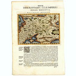
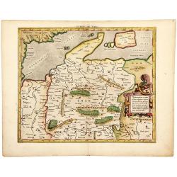
Descrittione Dell'Imperio della MOSCOVIA IMPERIUM.
Uncommon map including Latvia, Livonia, Lithuania, the Ukraine, and northern Part of the Black Sea and the Caspian Sea, Siberia, Georgia, Azerbaijan, Kazakhstan.Giovanni ...
Date: Venice, 1596
Tabula Asiae II.
A striking example of Magini's map of the Black Sea region from the 1597 edition of Magini's 'Geographia', based upon the work of Claudius Ptolemy. Latin text and tables ...
- $300 / ≈ €262
Date: Venice, 1597
Russiae, Moscoviae et Tartariae Descriptio.
Engraved by Frans Hogenberg from an original of 1562 by Anthony Jenkinson of the English Muscovy Company. The many vignettes are based on the reports of Marco Polo's expl...
Date: Antwerp, 1598
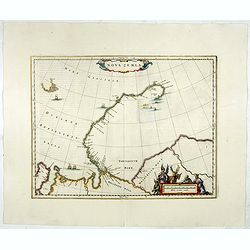
![[Nova Zembla]](/uploads/cache/44870-250x250.jpg)
[Nova Zembla]
Charming and decorative miniature map of the Russian island of Nowaya Zemlya. With the depiction of Barentsz.' route. With inset with 2 birds ("Loms Vögel oder Nort...
Date: Frankfurt am Main, 1604
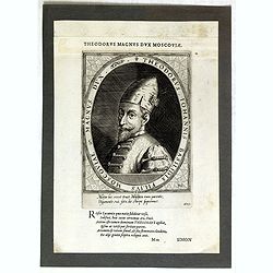
Theodorus Iohannis Basilidis Filius Moscoviae Magnus Dux / Atrium Heroicum.
Lettered with title around oval and two lines of Latin in lower margin: 'Mitior hic rexit ... / ... fato, de stirpe suprémus'. Lettered in letterpress above the platemar...
- $50 / ≈ €44
Date: Augsburg, 1601-1604
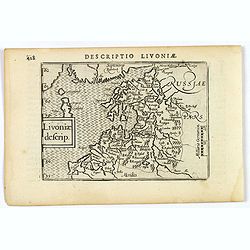
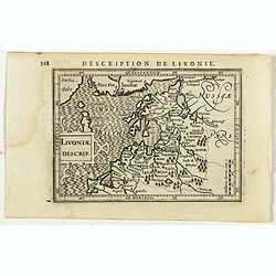
Livoniae descrip.
An attractive miniature map of the Baltic region of Livonia, as it was at the beginning of the seventeenth century, and published by Petrus Bertius in Amsterdam. The map ...
Date: Amsterdam, 1606
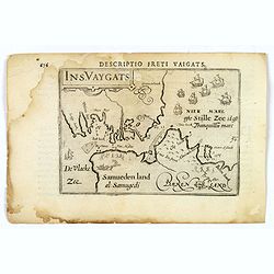
Descriptio Freti Vaigats.
Finely engraved map of the Vaigach Straits, from Bertius's rare miniature atlas. The map focuses on the straits between Novaya Zemlya and the Russian mainland, which had ...
- $150 / ≈ €131
Date: Amsterdam, 1606
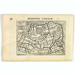
Tartaria.
A fine miniature map showing China, Korea and Russia. Title cartouche on the upper left corner. First published in 1598 in his Caert-Thresoor, the plates were executed by...
- $100 / ≈ €87
Date: Amsterdam, 1606
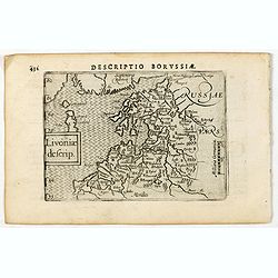
Descriptio Borussiae / Livoniae descrip.
A rare miniature map of Livonia. Title cartouche on the lower left corner.First published in 1598 in his Caert-Thresoor, the plates were executed by the most famous engra...
- $350 / ≈ €305
Date: Amsterdam, Cornelis Claes, 1606
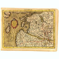
Livonia.
Scarce miniature map of Lithuania, from the first French-text edition of Jodocus Hondius' Atlas Minor. Engraved by Pieter Van Den Keere.Shortly after the publication of t...
- $300 / ≈ €262
Date: Amsterdam, Cloppenburgh, 1608
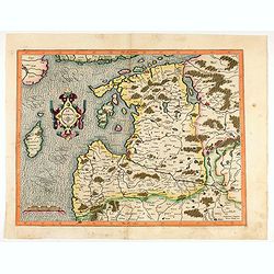
Latvia/ Estonia. Livonia.
A beautifully engraved map of Livonia – modern Latvia and Estonia – produced by two of the great fathers of modern cartography. Included are parts of the Baltic coast...
Date: Amsterdam, 1595-1609
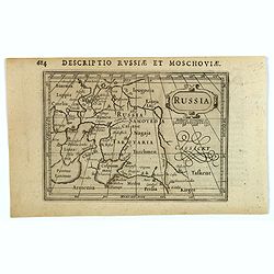
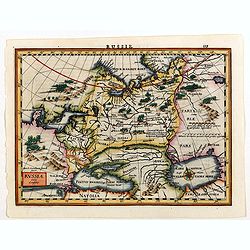
Russia.
Centered on Moscow, with the southern reaches of the map showing Persia, Armenia and Tashkent, the Black and Caspian Seas, and northward to Lapland and the frozen arctic ...
- $200 / ≈ €175
Date: Amsterdam, 1616
Livoniae Descrip.
A rare miniature map of the Baltic States Estonia, Latvia & Lithuania. The present map is one of the earliest obtainable maps to focus this region. Title cartouche o...
- $200 / ≈ €175
Date: Amsterdam, 1618
Moscovia.
Early map of Russia centered on Moscow published in his pocket atlas "Atlas Minor".
- $180 / ≈ €157
Date: Amsterdam, ca. 1625
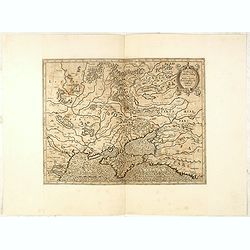
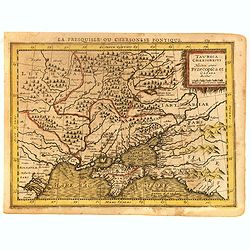
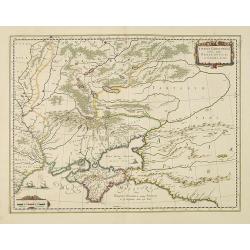
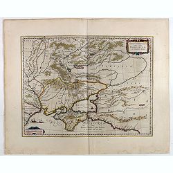
Taurica Chersonesus, Nostra aetate Prezecopsca, et Gazara dicitur.
Early and detailed map of the Ukraine, Russia with in the north Smolensk and Moscow and in the south the Black Sea. Shows ports, fortified cities and the mouths of the Da...
- $300 / ≈ €262
Date: Amsterdam, ca. 1625
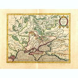
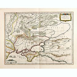
Taurica Chersonesus.
One of the earliest detailed maps of the Crimea and Ukraine between the northern coast of the Black Sea and Moscow.With the signature of Gerard Mercator in lower left cor...
Date: Amsterdam, 1628
Russia.
Russia map from the rare Cloppenburg edition slightly larger format and more scarce edition of the Mercator/Hondius "Atlas Minor". Engraved by Pieter Van Den Ke...
Date: Amsterdam, 1630
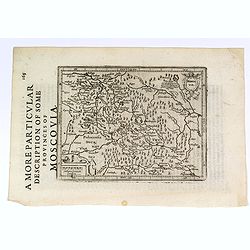
A More Particular Description of some Provinces of Moscovia.
From the English edition of the popular Mercator - Hondius atlas. English text to verso. This map elegantly depicts the Muscovy region of western Russia, with Moscow in t...
- $225 / ≈ €196
Date: Amsterdam, 1630
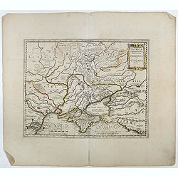
Taurica Chersonesus . . .
An attractive, detailed and early map of the Ukraine, Russia and surrounding regions between the northern coast of the Black Sea and Moscow.Shows ports, fortified cities ...
- $300 / ≈ €262
Date: Amsterdam, 1630
Livonia. 1627
Detailed map of the northern Baltic region. The map is centered on Riga and extends south to Memel, west to Poland and part of Russia and north to the Strait between Finl...
Date: Amsterdam, ca. 1630
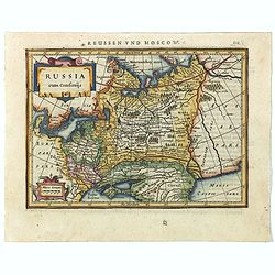
Russia cum Confinijs.
Charming small map of European Russia. Nicely detailed including engraved forests and mountains and embellished with two strapwork cartouches. Latin text on verso.
- $220 / ≈ €192
Date: Amsterdam, 1634
Russia cum confinijs.
A rare map of Russia in a first edition. In the second state the coastline of Scandinavia is completed, the title changed and the name of the engraver Dirck Cornelissen S...
- $250 / ≈ €218
Date: Amsterdam, Cloppenburgh, 1630-1636
Taurica Chersonesus, Nostra aetate Przecopsca, et Gazara dicitur.
Part of Russia with in the north Smolensk and Moscow and in the south the Black Sea.As Willem Blaeu died in 1638 most of his maps are actually published by his son Joan. ...
Date: Amsterdam, 1638
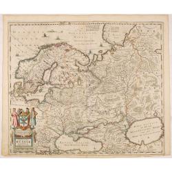
Tabula Russiae.
A re-issue, by Willem Blaeu, of Hessel Gerritsz' rare and influential map of Russia.This fine map was compiled from manuscripts brought back from Russia, by Isaac Massa, ...
Date: Amsterdam, 1644
Taurica Chersonesus, Nostra aetate Przecopsca, et Gazara dicitur.
Part of Russia with in the north Smolensk and Moscow and in the south the Black Sea. More about Willem Blaeu. [+]
- $300 / ≈ €262
Date: Amsterdam, 1644
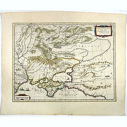
Taurica Chersonesus.
One of the earliest detailed maps of the Crimea and Ukraine between the northern coast of the Black Sea and Moscow.With the engraved signature of Gerard Mercator in lower...
- $300 / ≈ €262
Date: Amsterdam, 1639-1644
Novissima Russiae Tabula.
Detailed map of Russia including Scandinavia. Bottom left title cartouche and dedication. Prepared by Isaac Masso. Latin text on the verso.
Date: Amsterdam, 1645
Taurica Chersonesus, Nostra aetate Prezecopsca, et Gazara dicitur.
Part of Russia with in the north Smolensk and including Moscow and in the south the Black Sea.More about Willem Blaeu. [+]Taurica, Tauric Chersonese, and Taurida were nam...
- $500 / ≈ €436
Date: Amsterdam, 1645
Taurica Chersonesus, Nostra aetate Przecopsca, et Gazara dicitur.
Detailed map of the Ukraine, Russia with in the north Smolensk and Moscow and in the south the Black Sea. Shows ports, fortified cities and the mouths of the Danube. Mino...
- $750 / ≈ €655
Date: Amsterdam, 1645
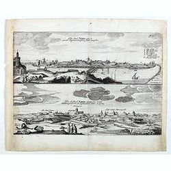
Die stadt Narva . . .
Two panoramic views of the city of Narva, on one sheet. Narva is the third largest city in Estonia. It is located at the eastern extreme point of Estonia, at the Russian...
- $250 / ≈ €218
Date: Schleßwig, Zur Glocken, 1647
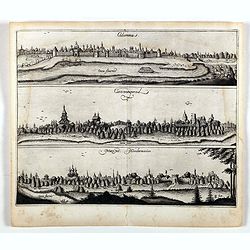
Colomna - Cassimogorod - Moruma.
Three panoramic views of Colomna - Cassimogorod - Moruma on one sheet. From the rare first edition "Offt begehrte Beschreibung der newen orientalischen Rejse, so dur...
- $300 / ≈ €262
Date: Schleßwig, Zur Glocken, 1647
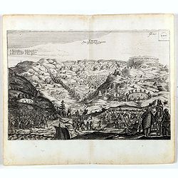
Tarku.
An early of Tarku in the Republic of Dagestan. From the rare first edition "Offt begehrte Beschreibung der newen orientalischen Rejse, so durch Gelegenheit einer Ho...
- $250 / ≈ €218
Date: Schleßwig, Zur Glocken, 1647
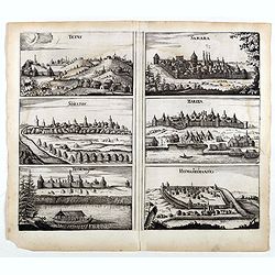
Tetus - Samara - Soratof - Zariza - Tzornogar - Kusmamedianski.
Panoramic views of Tetus, Samara, Soratof, Zariza, Tzornogar and Kusmamedianski on one sheet. From the rare first edition "Offt begehrte Beschreibung der newen orien...
- $300 / ≈ €262
Date: Schleßwig, Zur Glocken, 1647
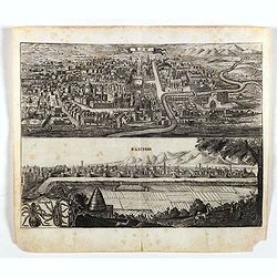
Kom - Kaschan.
An early of Kom and Kaschan on one sheet. From the rare first edition "Offt begehrte Beschreibung der newen orientalischen Rejse, so durch Gelegenheit einer Holstei...
- $250 / ≈ €218
Date: Schleßwig, Zur Glocken, 1647

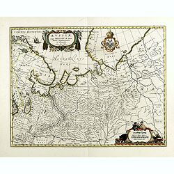
Russiae vulgo Moscovia dictae, Partes Septentrionalis et orientalis.
In the north the Murmansk Sea. Including the western coast of Nova Zembla. Title cartouche and two cartouches, the bottom right one showing two hunters, bears, stags etc....
Date: Amsterdam, 1647
Russiae vulgo Moscovia pars australis. . .
Shows southern Russia from Crimea to 60 degrees north and from the Volga west to Smolensk. Centered on Moscow. Prepared by Isaac Massa, a Dutch mapmaker who traveled to R...
Date: Amsterdam, 1650
Nova Zemla.
Decorative map decorated with hunters, polar foxes, polar bears and a sea monster.The scalebar in the lower right is in the form of a skewed 'checker-board', to reflect t...
- $900 / ≈ €785
Date: Amsterdam, 1650
MOSCOVIAE Pars Australis. Auctore Isaaco Massa.
Very decorative map of the region north of the Sea of Azov. The map is based on the travels of Isaac Massa who visited Moscow in 1600 and thus was in the midst of the tur...
- $350 / ≈ €305
Date: Amsterdam, 1650
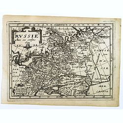
La Russie ou Moscovie.
Scarce map of Russia, centered on Moscow, the map covers much of central Europe, from the Baltic Sea east to the Caspian Sea and from the Arctic Ocean to the Black Sea.Fr...
- $300 / ≈ €262
Date: Paris, 1653
Russie avec ses confins...
A rare map published by Jean Boisseau (fl.1637-1658) French geographer, topographer, and genealogist in his Trésor des cartes géographiques. (The first true world atlas...
- $300 / ≈ €262
Date: Paris, 1653
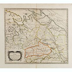
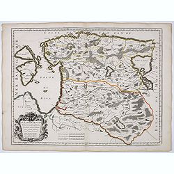
Sarmatia utraque europaea et asiatica. . .
Ancient map of the European part of Russia with the Ukraine. Dated 1654.Nicolas Sanson was to bring about the rise of French cartography, although the fierce competition ...
- $200 / ≈ €175
Date: Paris, 1654
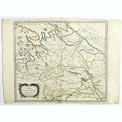
Sarmatia utraque europaea et asiatica. . .
Ancient map of the European part of Russia with the Ukraine. Dated 1654.Nicolas Sanson was to bring about the rise of French cartography, although the fierce competition ...
- $300 / ≈ €262
Date: Paris, 1654

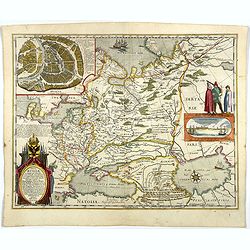
Moscovia urbs Metropolis totius Russiae Albae.
Detailed bird's-eye town-plan of Moscow from Janssonius' rare townbook. With a key (1-20) to important spots in town. The verso has French text and originates from Jansso...
Date: Amsterdam, 1657
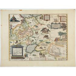
![Magni Ducatus Lithuaniae. . . (together with] Campus Inter Bohum et Borystenem. . .](/uploads/cache/49232-250x250.jpg)
Magni Ducatus Lithuaniae. . . (together with] Campus Inter Bohum et Borystenem. . .
Six sheet wall map of Lithuania and parts of Poland, Russia, Ukraine, Latvia, etc., extending to Cracow, Kyiv, Warsaw, Riga, Konigsberg, Danzig, Leopolis, etc.This is the...
Date: Amsterdam, 1658
Vera Delineatio Provinciae Fertilissimae Kilan olim Hyrcaniae ad Mare Caspium Sitae.
Uncommon map prepared by Adam Olearius showing the region of Azerbaijan and Iran. The map is oriented with north to the upper left corner and adorned with an attractive t...
- $400 / ≈ €349
Date: Jean Dupuis in Paris, 1659
Russiae, vulgo moscoviae dictae, partes septentrionalis et orientalis.
A finely engraved depiction of the area from Estonia to Moscow. The map is based on the travels of Isaac Massa, who visited Moscow in the early 1600s and thus was in the ...
- $550 / ≈ €480
Date: Amsterdam, 1660
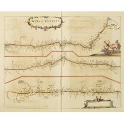
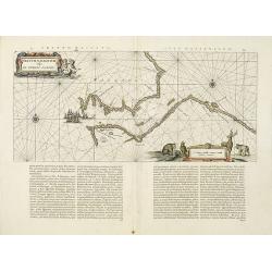
Dwina Fluvius.
An interesting strip-style map showing the course of the Dvina River in three sections from the Black Sea into the White Sea at Archangel. A group of reindeer and two str...
- $750 / ≈ €655
Date: Amsterdam, 1660
Russie blanche ou Moscovie.
Map of the European part of Russia centered on Moscow and prepared by N.Sanson. Published in an early edition of the small Sanson atlas L'Europe Dediée a Monseigneur . ....
- $100 / ≈ €87
Date: Amsterdam, ca. 1660
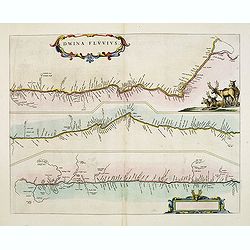
Dwina Fluvius.
An interesting strip-style map showing the course of the Dvina River in three sections from the Black Sea into the White Sea at Archangel. A group of reindeer and two str...
- $500 / ≈ €436
Date: Amsterdam, 1662
Fretum Nassovium vulgo de Straet Nassou.
Decorative map of the Nassau Strait, from the Atlas Major. Includes 2 compass roses, sailing ships, rhumb lines and 2 elaborate cartouches. Latin text below and on verso....
Date: Amsterdam, 1662
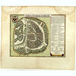
Benevole Lector, in hac tabulâ Urbis Moskuae . . .
Rare from his atlas Major. An extremely fine plan of Moscow, which is likely to have been based upon the survey ordered by Boris Fyodorovich Godunov. With a 60-point key,...
- $2750 / ≈ €2400
Date: Amsterdam, 1662
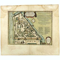
Kremlenagrad, Castellum urbis Moskvae . . .
Rare plan of the Kremlin, which appeared only in his Atlas Major. The map shows exceptional detail inside the heart of Moscow's inner walled fortress and the Kitai Gorod ...
- $2750 / ≈ €2400
Date: Amsterdam, 1662
La Livonie duché divisée en ses princip. parties Esten & Letten & c. / par le Sr. Sanson. . .
Fine map of the Baltic Coast from Riga to the Gulf of Finland, with the islands of Saaramaa and Hiiumaa off the coast of Estonia. Title cartouche in lower left corner and...
Date: Paris, 1663
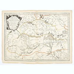
Partie de Lithuanie ou est en partie le Palatinat de Nowogrodeck Litawiski, subdivisé en leurs Chastellenies , le Palatinat de Bressici en Polesie, avec les duchés de Neswies, et Slusck, et partie du Palatinat de Minsk.
Scarce regional map, centered on Pinsk and showing Polish Lithuania, including part of modern Poland, Belarus, etc. This edition carries the date 1665. Nicolas Sanson was...
Date: Paris, 1665
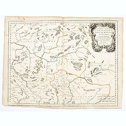
Partie de Lithuanie où sont les palatinats de Poloczk, Witepsk, Mseislaw, et partie de Minsk avec le duché de Smolensko.
Scarce and fine map of Belarus, including Smolensko in Russia and the region northeast of Minsk. This edition carries the date 1665 and the publishers address "A Par...
Date: Paris, 1665
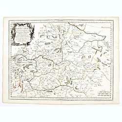
Partie de Lithuanie ou sont en partie les Palatinats de Wilna, et Troki, subdivisés en leurs Chastellenies et partie du Palatinat de Minsk.
Fine map of Lithuania. This edition carries the date 1665 and the publishers address "A Paris, chez Pierre Mariette, rue Saint Jacques a l'Esperance…"Nicolas ...
Date: Paris, 1666
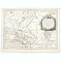
Partie de Lithuanie ou sont en partie les Palatinats de Minsk, et Mseislaw, we les Seign.Ries ou Terres de Rohaczow, Rzeczica, Zernobee, et partie des. . .
Fine map of Lithuania. This edition carries the publishers address "chez l'Autheur Avec privilege pour vingt ans 1666". Nicolas Sanson was to bring about the ri...
Date: Paris, 1666
Illyricum Orientis In quo Partes II. Moesia et Thracia. Provinciae XI.
Attractive historical map of the area west of the Black Sea, today's Bulgaria, Rumania, etc. Based on the cartography of Nicolas Sanson and published by P.Mariette. With ...
- $400 / ≈ €349
Date: Paris, 1666
Mer Noire ou Mer Maievre, . . .
Map of the Black Sea prepared by N.Sanson and published by Pierre Mariette.Published in an early edition of the small Sanson atlas L'Europe Dediée a Monseigneur . . . Le...
Date: Paris, P. Mariette, 1667
Moscovie avec ses confins.
Rare map of Russia, published by Jollain in 1667. Published in "Trésor Des Cartes Geographiques Des Principaux Estats de Lunivers".This atlas is based upon Boi...
- $450 / ≈ €393
Date: Paris, 1667
Russie.
Rare map of Russia, published by Jollain in 1667. Published in "Trésor Des Cartes Geographiques Des Principaux Estats de Lunivers".This atlas is based upon Boi...
- $250 / ≈ €218
Date: Paris, 1667
Russie Blanche ou Moscovie.
Map of the European part of Russia prepared by N.Sanson and published by Pierre Mariette.Published in an early edition of the small Sanson atlas L'Europe Dediée a Monsei...
Date: Paris, P. Mariette, 1667
