Browse Listings in America > South America > Guyana / Suriname
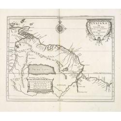
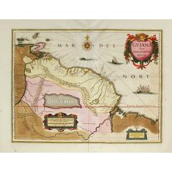
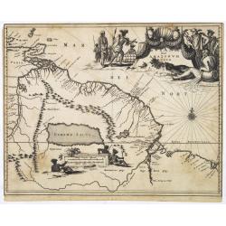
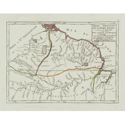
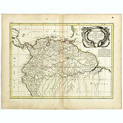
Guaiana sive Provinciae intra Rio De Las Amazonas atque Rio De Yviapari sive Orinoque.
Fine map showing northern coastline of South America from roughly the Amazon River to Trinidad Island. In the upper part of the map a large compass rose.Scarce map prepar...
Date: Leiden, Elzevier, 1625
Selling price: ????
Please login to see price!
Sold in 2013
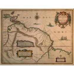
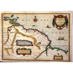
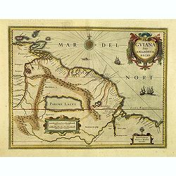
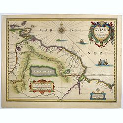
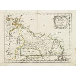
Guiana sive Amazonum Regio
Beautiful map extending from the Isla Margarita in the northwest to the coast of northern Brazil near Sao Luis east of the Amazon delta. At center lies a large inland sea...
Date: Amsterdam 1630
Selling price: ????
Please login to see price!
Sold in 2009
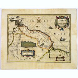
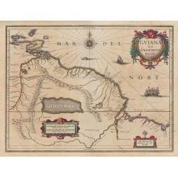
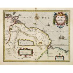
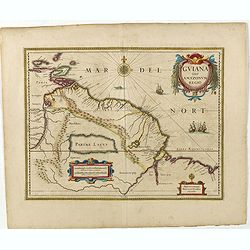
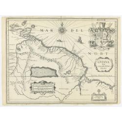
Guiana sive Amazonum Regio.
An important map extending from the Isla Margarita in the northwest, to the coast of northern Brazil near Sao Luis east of the Amazon delta. The map locates at its center...
Date: Amsterdam, ca. 1631
Selling price: ????
Please login to see price!
Sold in 2017
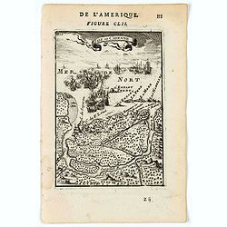
![[Indians of the Orinoco Delta, who live in trees] / [Sea monsters from Ralegh's expedition to Guyana].](/uploads/cache/41098-250x250.jpg)
[Indians of the Orinoco Delta, who live in trees] / [Sea monsters from Ralegh's expedition to Guyana].
Two engravings. [430] In the Orinoco delta, during the rainy season, no one could live at ground level because the river rose about 30 feet. During this time the Indians ...
Date: Frankfurt, M.Merian, 1633
Selling price: ????
Please login to see price!
Sold in 2018
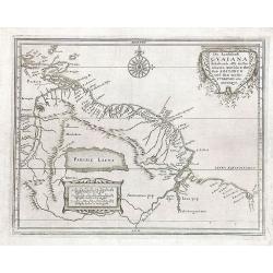
Die Landschafft Gvaiana Inhaltende alle die Prouincien awischen dem Fluss AMAZONVM und dem wasser YVIAPARI oder ORINOQVE
This map appeared in the "Historia antipodvm sive Novi Orbis, qvi vvlgo Americae et Indiae Occidentalis. . ., edited by J.L. Gottfried and published by Matthas Meria...
Date: Frankfurt, M. Merian, 1633-1634
Selling price: ????
Please login to see price!
Sold in 2018
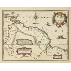
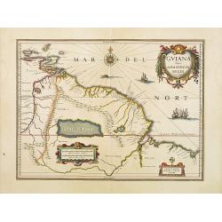
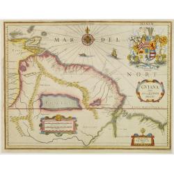
Guiana Siue Amazonu, Regio
Striking. 1635 map of the northwestern part of South America including Lake Parima (Parime Lacus), and the route to El Dorado. The map covers from Isla Margarita and the ...
Date: Amsterdam, 1635
Selling price: ????
Please login to see price!
Sold in 2016
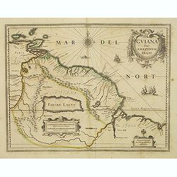
Guiana sive Amazonum Regio.
Nice map extending from the Isla Margarita in the northwest to the coast of northern Brazil near Sao Luis east of the Amazon delta. The map locates at its center a large ...
Date: Amsterdam, c.1635
Selling price: ????
Please login to see price!
Sold in 2011
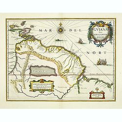
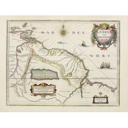
Guiana sive Amazonum Regio.
Willem Blaeu’s decorative map of the Guianas, Lake Parima (Parime Lacus), and the route to El Dorado was initially issued in 1630 (with some variants were published well ...
Date: Amsterdam, 1638
Selling price: ????
Please login to see price!
Sold in 2026
Guiana sive Amazonum Regio.
Important map extending from the Isla Margarita in the northwest to the coast of northern Brazil near Sao Luis east of the Amazon delta. The map locates at its center a l...
Date: Amsterdam, 1638
Selling price: ????
Please login to see price!
Sold in 2012
Guiana sive Amazonum Regio.
Copper engraving, hand colored in outline when published. A highly decorative map showing Guiana extending westwards to Trinidad and Margarita Island, dominated by a huge...
Date: Amsterdam, 1638
Selling price: ????
Please login to see price!
Sold in 2012
Guiana sive amazonum regio.
This decorative map shows Guiana with the neighboring Trinidad and the adjacenting Amazon river. In the left lower side is a decorative renaissance mileage scale and in t...
Date: Amsterdam, 1638
Selling price: ????
Please login to see price!
Sold in 2010
Guiana sive Amazonum Regio.
Nice map extending from the Isla Margarita in the northwest to the coast of northern Brazil near Sao Luis east of the Amazon delta. The map locates at its center a large ...
Date: Amsterdam, 1640
Selling price: ????
Please login to see price!
Sold in 2008
Guiana sive Amazonum Regio.
Nice map extending from the Isla Margarita in the northwest to the coast of northern Brazil near Sao Luis east of the Amazon delta. The map locates at its center a large ...
Date: Amsterdam, 1640
Selling price: ????
Please login to see price!
Sold in 2026
Guiana sive Amazonum Regio.
Important map extending from the Isla Margarita in the northwest to the coast of northern Brazil near Sao Luis east of the Amazon delta. The map locates at its center a l...
Date: Amsterdam, ca.1645
Selling price: ????
Please login to see price!
Sold in 2018
Guiana sive Amazonum Regio.
Copper engraving, hand colored in outline when published. A highly decorative map showing Guiana extending westwards to Trinidad and Margarita Island, dominated by a huge...
Date: Amsterdam, 1645
Selling price: ????
Please login to see price!
Sold in 2026
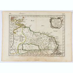
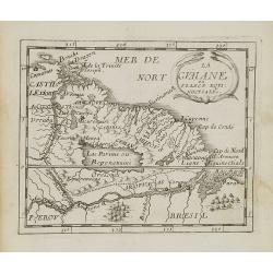
Guiane divisee en Guiane, et Caribane. . .
Map of Guinea prepared by N.Sanson and published by Pierre Mariette. This is a reduced derivative of the famous Sanson map of 1650.Published in an early edition of the sm...
Date: Paris, P. Mariette, 1656
Selling price: ????
Please login to see price!
Sold in 2025
Guiana sive Amazonum Regio.
A very decorative map of Suriname, which extends from the Isla Margarita in the northwest to the coast of northern Brazil near São Luís, east of the Amazon delta. The map...
Date: Amsterdam, 1658
Selling price: ????
Please login to see price!
Sold in 2026
Guiana sive Amazonum Regio.
First edition of the last part of the Latin "Atlas maior" dedicated to America.Nice map extending from the Isla Margarita in the northwest to the coast of north...
Date: Amsterdam, 1662
Selling price: ????
Please login to see price!
Sold in 2009
Guiane divisee en Guiane, et Caribane. . .
Map of Guinea prepared by N.Sanson and published by Pierre Mariette. This is a reduced derivative of the famous Sanson map of 1650.Published in an early edition of the sm...
Date: Paris, P. Mariette, 1667
Selling price: ????
Please login to see price!
Sold in 2008
Guiana sive Amazonum regio.
This very rare map shows northwest Latin America with Surinam and French Guiana and was engraved by Johann Philipp Thelott. The map comes from the work of Johann Joachim ...
Date: Frankfurt, 1669
Selling price: ????
Please login to see price!
Sold in 2026
GUIANA sive Amazonum Regio.
Extremely rare map published by J.P. Thelott, extending from the Isla Margarita in the northwest to the coast of northern Brazil near Sao Luis east of the Amazon delta. T...
Date: Franckfurt 1669
Selling price: ????
Please login to see price!
Sold
Guiana sive Amazonum Regio.
Map of Guiana and Amazon extending westwards to Trinidad and Margarita Island, dominated by a huge inland sea north of the Amazon.Embellished with decorative title and sc...
Date: Amsterdam, 1673
Selling price: ????
Please login to see price!
Sold in 2025
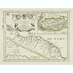
Coste de Guayane autrement Franc Equinoctale en la Terre-Ferme d'Amerique suivant les Dernières Relations . . .
Uncommon map of the French colony Guyana in southern American Guyana, with a detailed enlargement of Cayenne in the upper right corner ( 155X110mm.), with fine title cart...
Date: Paris, 1676
Selling price: ????
Please login to see price!
Sold in 2026
La Guaiane.
Uncommon miniature map of French Guyana in Latin America from Pierre Duval\'s La Geographie Universeille dated 1676. It is bordered to the east by Suriname, to the south ...
Date: Paris, 1676
Selling price: ????
Please login to see price!
Sold in 2008
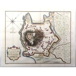
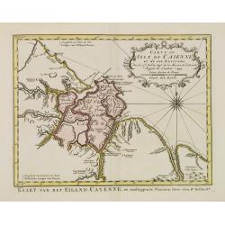
Isle de Cayenne.
A charming map of Cayenne, with Fort St Louis and a naval battle in the fore ground. Title in curtain draped at top. French text on verso.From the original 1683 text edit...
Date: Paris, 1683
Selling price: ????
Please login to see price!
Sold in 2022
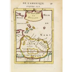
Pays des Caribes et Guiane.
Interesting map depicting the north coast of South America between the Orinoco and the Amazonas rivers, appreciatively corresponding to the Guianas. From the French text ...
Date: Paris 1683
Selling price: ????
Please login to see price!
Sold in 2008
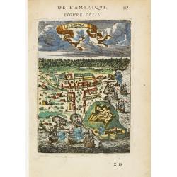
F. Lovys.
Bird's-eye view of Fort Louis on the island of Cayenne, besieged by fighting ships.From the French text edition of Description d'Univers, 1683. by Allain Manneson Mallet ...
Date: Paris 1683
Selling price: ????
Please login to see price!
Sold
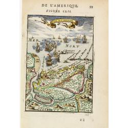
Isle de Cayenne.
Dramatic view of the island of Cayenne, off French Guyana, showing Fort Louis and a fierce sea battle being waged just off shore.From the French text edition of Descripti...
Date: Paris 1683
Selling price: ????
Please login to see price!
Sold in 2008
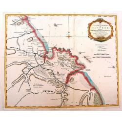
Nieuwe kaart van Suriname vertonende de stromen en land-streken van Suriname, Comowini, Cottica en Marawini, gelegen in Zuid America op de kusten van Caribana. . .
Decorative full color example of Ottens map of Suriname. Detailed map of the northeast part of Suriname between Paramaribo, with fort Zeelandia, and Mana. Along the Surin...
Date: Amsterdam, ca. 1700
Selling price: ????
Please login to see price!
Sold

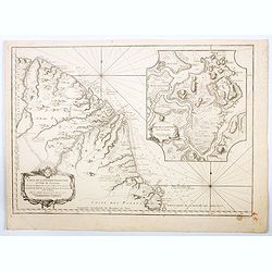
Nieuwe gelyk Graadige Paskaart van de Kust van Guiana in West-Indien.
Detailed chart of Guiana in South America. Two scales are given in both maps: Dutch, French and English nautical miles.The inset chart provide detailed view of the Camopi...
Date: Amsterdam, 1684 - 1704
Selling price: ????
Please login to see price!
Sold in 2026
![[Lot of 10 (2x maps / 8x views of Guyana)] d' Engleze Volksplanting in' t Amerikaans Gewest Gujana en Rio de Las Amazones. Door de Scheeps-Togt van Charles Leig Begonnen.](/uploads/cache/IMG_2322-250x250.jpg)
[Lot of 10 (2x maps / 8x views of Guyana)] d' Engleze Volksplanting in' t Amerikaans Gewest Gujana en Rio de Las Amazones. Door de Scheeps-Togt van Charles Leig Begonnen.
[Lot of 10 (2x maps / 8x views of Guyana]- d'Engelze Volkplanting in't Amerikaans gewest Gujana en Rio de las Amazones. circa 1700 - Land-Kaart van het Eiland en de Volk...
Date: Leiden, 1706-1707
Selling price: ????
Please login to see price!
Sold in 2023
d' Engleze Volksplanting in' t Amerikaans Gewest Gujana en Rio de Las Amazones. Door de Scheeps-Togt van Charles Leig Begonnen.
Pieter van der Aa was a prolific publisher. He published a.o. ' Naaukeurige versameling der gedenkwaardigste zee- en land-reysen', a series of accounts of voyages (1706-0...
Date: Leiden, 1707
Selling price: ????
Please login to see price!
Sold
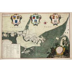
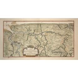
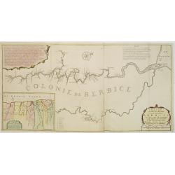
Platte Grond van Rio de Berbice.
Jan Daniel Knapp?s large-scale map of the Dutch plantations along the river Berbice in present day Guyana. The map shows the division of property and plantations and the ...
Date: Amsterdam, 1720
Selling price: ????
Please login to see price!
Sold

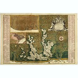
Nieuwe gemeten kaart van de colonie de Berbice : met der zelver plantagien en de namen der bezitters in het ligt gebragt door Reiner & Iosua Ottens kaartverkopers te Amsterdam 1740.
Rare, separately published map of the colony of Berbice in present-day Guyana showing the Berbice River Valley and the plantations along the river. North on the map of th...
Date: Amsterdam, 1740
Selling price: ????
Please login to see price!
Sold in 2026
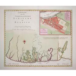
Algemene kaart van Suriname Algemeene kaart van de Colonie of Provintie van Suriname : met de rivieren, districten, ontdekkingen door militaire togten. . .
Uncommon large scale map of of Suriname, indicating the different plantations and their owners. Consists of two glued-together sheets. Completed with funding by the Direc...
Date: Amsterdam, 1740
Selling price: ????
Please login to see price!
Sold in 2023
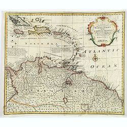
A New and Accurate Map of Terra Firma and the Caribbe Islands.
This is Emmanuel Bowen's attractive, decorative map of the Caribbean Islands, extending from eastern Cuba and Jamaica to Trinidad, and northern South America (Columbia, V...
Date: London, ca 1747
Selling price: ????
Please login to see price!
Sold in 2018
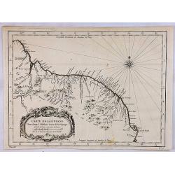
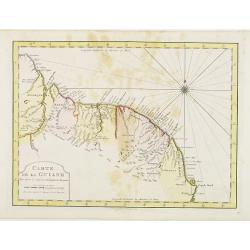
Partie Orientale de la Terre Ferme ou l'on trouve la Guiane.
Nice small map encompassing a large area between the Orinoco and the River Amazon.From Atlas Portatif Universel, by Robert de Vaugondy.Page 107 outside border top right. ...
Date: Paris, later than 1749
Selling price: ????
Please login to see price!
Sold in 2026
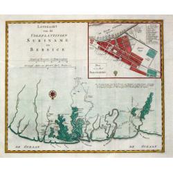
Landkaart van de volkplantingen Suriname en Berbice.
Izaak Tirion (d. 1769) Amsterdam publisher. His ' Nieuwe en beknopte handatlas' saw 6 editions between before 1740 and after 1784. Also ' Tegenwoordige staat van alle vol...
Date: Amsterdam. C. 1750
Selling price: ????
Please login to see price!
Sold
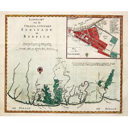
Landkaart van de volkplantingen Suriname en Berbice.
Izaak Tirion (d. 1769) Amsterdam publisher. His '' Nieuwe en beknopte handatlas'' saw 6 editions between before 1740 and after 1784. Also '' Tegenwoordige staat van alle ...
Date: Amsterdam. C. 1750
Selling price: ????
Please login to see price!
Sold in 2009
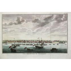
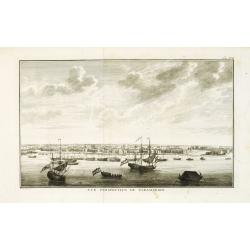
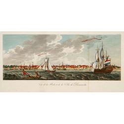
Vuë perspective de Paramaribo.
Attractive view of Paramaribo as seen from the sea, with in the front ships on the roads, to the right fort Zeelandia.
Date: Amsterdam, c. 1750
Selling price: ????
Please login to see price!
Sold
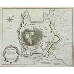
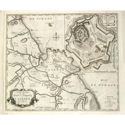
La Ville de Cayenne.
Plan of the city of Cayenne from Histoire générale des voyages … by Antoine François Prévost, published by Didot.
Date: Paris, 1752
Selling price: ????
Please login to see price!
Sold in 2011
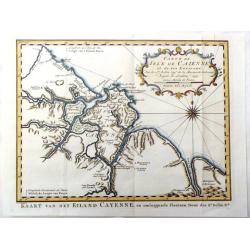
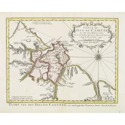
Carte de Isle de Caienne et ses Environs.
Attractive map of the coast of French Guyana on the western coast of South America. Decorated by a fine title cartouche and compass rose.From Raynal's "Histoire Phil...
Date: Paris, 1753
Selling price: ????
Please login to see price!
Sold in 2016
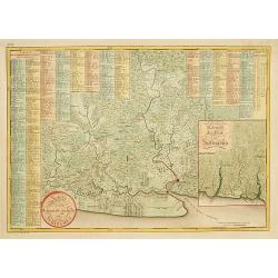
Landkaart van den Volkplantingen Surianme en Berbice.
Beautifully delineated map of Suriname identifying major plantations, waterways and towns. There is a plan of the capital, Paramaribo, in the upper right and corner with ...
Date: Amsterdam, ca. 1755
Selling price: ????
Please login to see price!
Sold in 2011
Carte de la Guyane.
A map of the Guyanas - present day Guyana, Suriname and French Guiana, including Paramaribo and Cayenne. The map features a decorative rococo style title cartouche. By Be...
Date: Paris, 1757
Selling price: ????
Please login to see price!
Sold in 2018
La ville de Cayenne de Stad Cayenne.
A fine city plan of the town of Cayenne in French Guyana in South America by J.N. Bellin, and engraved by J. Van Der Schley in 1757. From "Histoire Generale des Voya...
Date: Paris, 1757
Selling price: ????
Please login to see price!
Sold in 2016
The Island & Colony of Cayenne Subject to the French, on the Continent of South America.
Scarce map of French Guiana was created by Thomas Jefferys (1695-1771) in 1760. He was geographer to his Royal Highness, the Price of Wales and was one of the most prolif...
Date: London, 1760
Selling price: ????
Please login to see price!
Sold in 2014
![[A lot of 5 map of Guyana.] Land-kaart van Cayenne.](/uploads/cache/20452-250x250.jpg)
[A lot of 5 map of Guyana.] Land-kaart van Cayenne.
An attractive map of the island and settlement of Cayenne, with an inset picturing a plan of the town and fort of Cayenne. Izaak Tirion (d. 1769) Amsterdam publisher. Hi...
Date: Amsterdam, c. 1760
Selling price: ????
Please login to see price!
Sold in 2022

Nieuwe gemeten kaart van de colonie de Berbice met der zelver plantagiën en de namen der Bezitters. . .
Re-issue of his map from 1740, without the printed list of owners, with a large added contemp. hand-colored cartouche Relaas van de rebellie, ontstaan op de plantagien in...
Date: Amsterdam, ca.1763
Selling price: ????
Please login to see price!
Sold in 2026
Carte de la guyans Francois et l'isle de Cayenne. . .
A detailed and well engraved sea chart of French Guiana and the island of Cayenne, via a large inset. The map was published in 1763 by Bellin (1703-72), a high output car...
Date: Paris, 1763
Selling price: ????
Please login to see price!
Sold in 2020
Carte de la Guyane Françoise et l'Isle de Cayenne..
A well engraved and highly detailed chart of French Guiana and the island of Cayenne. Made in 1763 by Jacques Bellin (1703-72), a prolific cartographer assigned the Minis...
Date: Paris, 1763
Selling price: ????
Please login to see price!
Sold in 2026
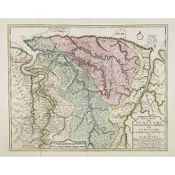
Carte d'une Grande Partie de la Colonie de Surinam.
Nice map of the Dutch colony of Suriname with excellent detail of the Suriname and Commewijne river systems, noting the boundaries of all the plantations laid along their...
Date: Paris, ca. 1764
Selling price: ????
Please login to see price!
Sold in 2008
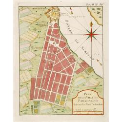
Plan de la Ville de Paramaribo Suivant les Plans Hollandois
Fine map of Panama Bay. From "Petit Atlas Maritime ". Jacques Nicolaas Bellin (1703-1772) was one of the most important and proficient French cartographers of t...
Date: Paris 1764
Selling price: ????
Please login to see price!
Sold
Nieuwe..kaart van de colonie Berbice..
Re-issue of his map from 1740, without the printed list of owners, with a large added contemp. hand-colored cartouche Relaas van de rebellie, ontstaan op de plantagien in...
Date: Amsterdam 1765
Selling price: ????
Please login to see price!
Sold
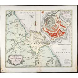
Land-Kaart van het Eiland en de Volkplanting van Cayenne aan de Kust van Zuid-Amerika
Attractive engraved map of French Guyana by I. Tirion. Showing the coast of French Guyana with a plan of Cayenne and the fortifications. With two cartouches and a compass...
Date: Amsterdam, 1765
Selling price: ????
Please login to see price!
Sold in 2009
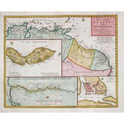
Kaart van geheel Guajana of de Wilden -Kust / Het Eiland Kurassau. / De Haven en \'t Kasteel van Kurassau / Kaart van de Volksplanting aan Demerary en Rio d\'Essequebo.
Isaak Tirion (d. 1769) Amsterdam publisher. His 'Nieuwe en beknopte handatlas' saw 6 editions between before 1740 and after 1784. Also 'Tegenwoordige staat van alle volke...
Date: Amsterdam, 1765
Selling price: ????
Please login to see price!
Sold in 2009
Land-kaart van het Eiland en de Volkplanting van Cayenne aan de Kust van Zuid-Amerika.
Izaak Tirion (d. 1769) Amsterdam publisher. His ' Nieuwe en beknopte handatlas' saw 6 editions between before 1740 and after 1784. Also ' Tegenwoordige staat van alle vol...
Date: Amsterdam, 1765
Selling price: ????
Please login to see price!
Sold
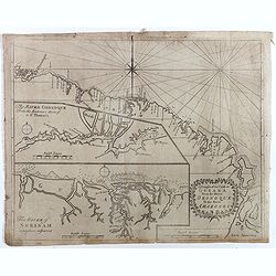
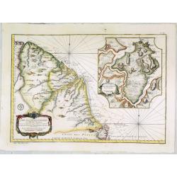
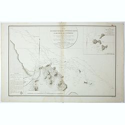
A Draught of the Coast of GUIANA From the River Oronoque To the River Amazones.
Rare chart with the coastline of the Guyana's with small insets of two charts of The River Oronoque from the entrance to St. Thomas's and The River of Surinam. Compass po...
Date: Dublin, 1767
Selling price: ????
Please login to see price!
Sold in 2017

Carte Particuliere d'une Partie des Riviers de Berbice et de Caroje, Pour L'Intelligence de la Relation Touchant l Revolt des Negres en 1763
Plan of Berbice, Surinam at the time of the slave revolt of 1763. The slaves revolted and forced the plantation owners out of the country.
Date: Amsterdam, 1773
Selling price: ????
Please login to see price!
Sold in 2018
Carte de L'Isle de Caiene et de ses environs.
Uncommon edition of this accurate map of Cayenne. In the lower right, engraved "31."From Atlas Portatif pour servir à l'intelligence de l'Histoire Philosophique...
Date: Amsterdam, 1773
Selling price: ????
Please login to see price!
Sold in 2026
Carte de L'Isle de Caiene et de ses environs.
Uncommon edition of this accurate map of Cayenne.From Atlas Portatif pour servir a l'intelligence de l'Histoire Philosophique et Politique des etablissements et du commer...
Date: Amsterdam, 1773
Selling price: ????
Please login to see price!
Sold in 2022
Carte de La Guiane..
Uncommon edition of this accurate map of part of Brazil. In lower right engraved "32."From Atlas Portatif pour servir a l'intelligence de l'Histoire Philosophiq...
Date: Amsterdam, 1773
Selling price: ????
Please login to see price!
Sold in 2022
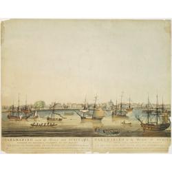
Vue de la Rade et de la Ville de Paramaribo.
A very decorative panoramic view of the town with a large Dutch vessel in the foreground. Engraved by Noach van der Meer Junior. Included in a Dutch edition of "Hist...
Date: Amsterdam, 1774
Selling price: ????
Please login to see price!
Sold in 2026
Carte de la Terre Ferme de la Guyane et du Pays des Amazones . . .
Attractive map of Guyana and Amazonia, ornated with a decorative title cartouche. Boundaries outlined in hand color.Prepared by Le Sieur Janvier, Jean Denis [Robert], Fre...
Date: Paris, ca 1783
Selling price: ????
Please login to see price!
Sold in 2019

Guyana, Surinam, Amapa.
Very rare Ottoman printed map of Guyana, Suriname and Amapa. With Trinidad, an inset map of the mouth of the Rivers Essequibo, Courantyne, Suriname with Paramaribo.From C...
Date: Uskudar (Istanbul), 1803
Selling price: ????
Please login to see price!
Sold in 2024
Vue de la Rade et de la Ville de Paramaribo.
A very decorative panoramic view of the town with a large Dutch vessel in the foreground.
Date: Paris 1810
Selling price: ????
Please login to see price!
Sold
Kaart van het bebouwde gedeelte van Suriname.
With inset map of general Suriname. Scarce map covering the area of Paramaribo. 751 Plantation identified to key panels at top and left of the sheet.
Date: Amsterdam, 1810
Selling price: ????
Please login to see price!
Sold in 2013
Paramaribo aan de Rivier van Suriname.
Very rare and decorative panoramic view of the city of Paramaribo as seen from the river. The best 19th century view of Paramaribo. The houses shown are typical Dutch in ...
Date: Amsterdam 1817
Selling price: ????
Please login to see price!
Sold
Plan de l'Embouchure de la Rivière de Cayenne et des Mouillages extérieures. . .
Early chart of coast offshore to Cayenne.
Date: Paris, ca.1822
Selling price: ????
Please login to see price!
Sold in 2018
Plan de l'Embouchure de la Rivière de Cayenne et des Mouillages extérieures. . .
Early chart of coast offshore to Cayenne. Prepared by C.L. Grassier and engraved by Ambroise Tardieu and P.J. Besançon. Detailed chart published by Dépôt Générale de la M...
Date: Paris, ca.1822
Selling price: ????
Please login to see price!
Sold in 2020
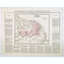
Carte Geographique, Statistique et Historique de la Guyane.
A nice detailed map of Guyana from Buchon's Atlas Gégraphique Statistique, historique et chronologique des deux Ameriques et des isles adjacentes traduit de l'atlas exécu...
Date: Paris, 1825
Selling price: ????
Please login to see price!
Sold in 2026
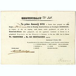
Certificaat N° 230
Text reads "Na primo januarij 1872 is houder dezes geregtigd voor 2/2147 tot hetgeen, ter zake van verjariing, zoude kunnen worden gereclmeerd, uiy gelden bij de Ass...
Date: Amsterdam, 1841
Selling price: ????
Please login to see price!
Sold in 2026
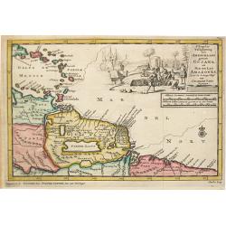
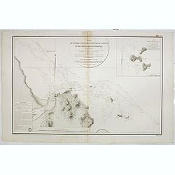
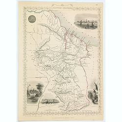
British Guayana.
Pleasing map of British Guyana with four fine lithographed vignettes of scenes from Guyana. It was drawn and engraved by J. Rapkin and published in London by John Tallis ...
Date: London, 1850
Selling price: ????
Please login to see price!
Sold in 2016
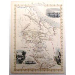
British Guayana.
A decorative steel engraved map of British Guyana. The last Tallis map of the region, published circa 1858 by The London Printing and Publishing Company (the partnership ...
Date: London, 1858
Selling price: ????
Please login to see price!
Sold in 2020
![[Lot of 12 maps and prints relating to Surinam and South America and map of The Netherlands]](/uploads/cache/48306-250x250.jpg)
[Lot of 12 maps and prints relating to Surinam and South America and map of The Netherlands]
A lot of 12 maps and prints of Surinam, South America and one of the Netherlands. Including Bellin's maps of "Carte de l'Isle de Cayenne et de ses Environs (205x285m...
Date: Netherlands, Paris, ca. 1700-1880
Selling price: ????
Please login to see price!
Sold in 2022
![[Detailed folding map of Nickerie River, Nickerie, Coronie in Suriname]](/uploads/cache/47218-250x250.jpg)
[Detailed folding map of Nickerie River, Nickerie, Coronie in Suriname]
Detailed folding map of Nickerie River, Nickerie, Coronie in Suriname. The Nickerie is a river in the northwestern part of Suriname. The river originates in the Bakhuis M...
Date: Surinam, or Netherlands, ca. 1900
Selling price: ????
Please login to see price!
Sold in 2022
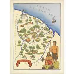
Guyane.
Very decorative, informative map of French Guyne. The map is filled with buildings, animals, figures and two locals in their typical dress.In lower left corner "Impr...
Date: France, 1943
Selling price: ????
Please login to see price!
Sold in 2014
