Browse Listings in Europe > British Isles
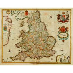
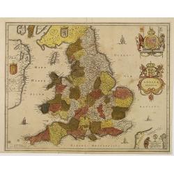
Anglia Regnum.
Janssonius' map of England and Wales was one of the new maps prepared by him in 1636. His map closely copies the similar map issued two years earlier by Willem Blaeu.. Th...
Date: Amsterdam 1639-1644
Selling price: ????
Please login to see price!
Sold
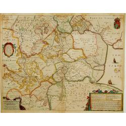
A general Plott and description of the Fennes..
Fine map depicting the area north of Cambridge, up to King's Lynn. West to the top. ┬░
Date: Amsterdam, 1639-1644
Selling price: ????
Please login to see price!
Sold in 2011
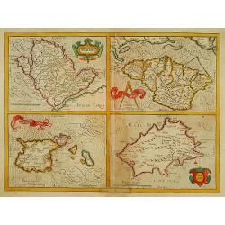
Anglesey./Iarsay./Garnesay./ Wight Vectis Olim.
Four maps on one sheet depicting the English islands Jersey, Guernsey, Wright and Alderney.
Date: Amsterdam 1639-1644
Selling price: ????
Please login to see price!
Sold
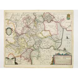
A general Plott and description of the Fennes..
Fine map depicting the area north of Cambridge, up to Kings Lynn. West to the top.
Date: Amsterdam 1639-1644
Selling price: ????
Please login to see price!
Sold in 2008
Anglia Regnum.
Janssonius' map of England and Wales was one of the new maps prepared by him in 1636. His map closely copies the similar map issued two years earlier by Willem Blaeu.The ...
Date: Amsterdam, 1639-1644
Selling price: ????
Please login to see price!
Sold in 2012
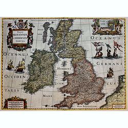
Magnae Britanniae et Hiberniae Tabula.
A splendid finely engraved map of England from the most important Dutch map publishers of the 17th century, the Hondius dynasty.
Date: Amsterdam, 1639-1644
Selling price: ????
Please login to see price!
Sold in 2017
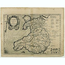
Cambriae Typus.
Ancient map of Wales, prepared by Humphrey Lhuyd. With fine cartouche, part of a compass-rose and a sea monster.No text on verso. From a French composite atlas.Read more ...
Date: Amsterdam, 1639-1644
Selling price: ????
Please login to see price!
Sold in 2018
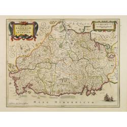
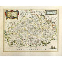
Comitatus Lageniae. The Countie of Leinster.
Finely engraved map of the eastern part of Ireland. Orientated with the West on top. Decorated with vessels, title cartouche and scale of miles cartouche. Relief shown pi...
Date: Amsterdam 1645
Selling price: ????
Please login to see price!
Sold
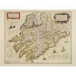
Provincia Momoniae. The province of Mounster.
Fine map of southern part of Ireland. Adorned with vessels, sea monsters, a compass rose and two very decorative cartouches.
Date: Amsterdam 1645
Selling price: ????
Please login to see price!
Sold
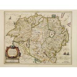
Provincia Ultoniae. The province of Ulster.
Finely engraved map of Ulster. Adorned with vessels and a decorative title cartouche. Relief shown pictorially. Illustrated topography shows towns, river systems and indi...
Date: Amsterdam 1645
Selling price: ????
Please login to see price!
Sold
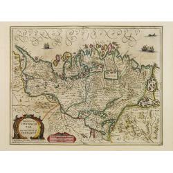
Provincia Connachtiae. The province of Connaught.
Finely engraved map of the north-western part of Ireland. Adorned with vessels, sea monsters and two very decorative cartouches. Relief shown pictorially. Illustrated top...
Date: Amsterdam 1645
Selling price: ????
Please login to see price!
Sold
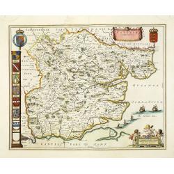
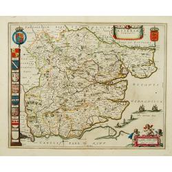
Essexia Comitatus.
Double-page attractive map of the country of Essex. Showing London in the lower left corner, and other towns such as West Ham, East Ham, Waltham stow, South end on Sea, H...
Date: Amsterdam, 1645
Selling price: ????
Please login to see price!
Sold in 2011
De Noort Cust van Engelandt / tusschen Crammer en / de Revier van / Nicastle. 12
Father Jacob (1600-73) and son Arnold Colom (1624-68) were highly successful publishers of nautical charts. ' Vyerige Colom', in Dutch, French and English editions, sea-a...
Date: Amsterdam, 1645
Selling price: ????
Please login to see price!
Sold in 2011
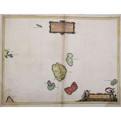
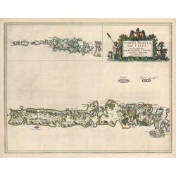
Insulae Quaedam Minores ex Aebudis quae Mulam et Skiam. . .
Insulae Quaedam Minores ex Aebudis quae Mulam et SkiamŌĆ”c1634 by Joan Blaeu after Timothy Pont. Sub-titled "Some of the Smaller Western Yles, lying between the Yles...
Date: Amsterdam, 1645
Selling price: ????
Please login to see price!
Sold in 2012
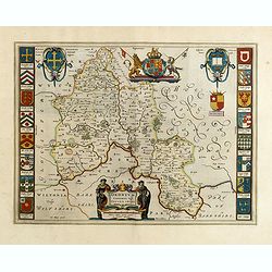
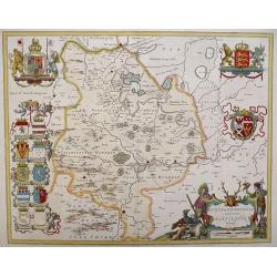
Oxonium Comitatus, Vulgo Oxford shire.
Double-page map of the county of Oxford on the Thames River. This English county map is highly decorative with figurative title cartouche of two scholars. Royal arms and ...
Date: Amsterdam, 1645
Selling price: ????
Please login to see price!
Sold in 2015
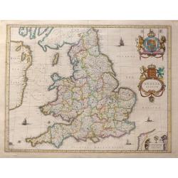
Anglia Regnum.
Willem Blaeu was the first to bring out a new map of England and Wales. The outline and place names are taken from Speed with county boundaries marked but no border figur...
Date: Amsterdam, 1645
Selling price: ????
Please login to see price!
Sold in 2016
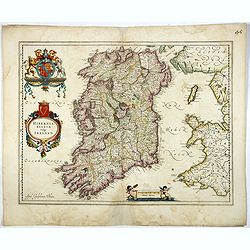
Hibernia regnum vulgo Ireland.
Standard map of Ireland embellished with decorative coat of arms, cartouche with title and a scale cartouche showing two putti. The map is heavily based on an earlier map...
Date: Amsterdam, 1645
Selling price: ????
Please login to see price!
Sold in 2017
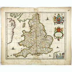
Anglia Regnum.
Willem Blaeu was the first publisher to bring out a new map of England and Wales. The outline and place names are taken from Speed with county boundaries marked but no bo...
Date: Amsterdam, 1645
Selling price: ????
Please login to see price!
Sold in 2017
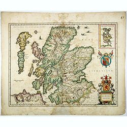
Scotia Regnum.
A attractive example of this fine map of Scotland with two coats of arms and an in-set map of the Orkney Islands.
Date: Amsterdam, ca.1645
Selling price: ????
Please login to see price!
Sold in 2017
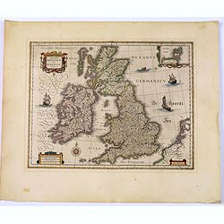
Magnae Britanniae et Hiberniae Tabula.
Map of Great Britain comprising England, Scotland, and Wales. Small inset map of the Orkneys, galleons, a compass rose, cartouches and sea-monster. French text on verso. ...
Date: Amsterdam, 1645
Selling price: ????
Please login to see price!
Sold in 2017
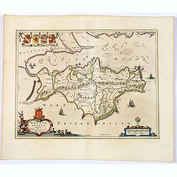
Vectis Insula. Anglice The Isle of Wight.
A beautifully engraved map seventeenth-century map of the Isle of Wight, just off the southern English coast. Features a nice decorative title cartouche in lower left cor...
Date: Amsterdam, 1645
Selling price: ????
Please login to see price!
Sold in 2018
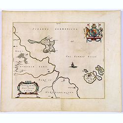
Insula Sacra, Vulgo Holy Iland, et Farne.
Double-page map of Holy Island and Farne Island off the coast of Northumberland. The Abbey, the Old Fort and the town are clearly marked. Latin text on verso.Taken from J...
Date: Amsterdam, 1645
Selling price: ????
Please login to see price!
Sold in 2018
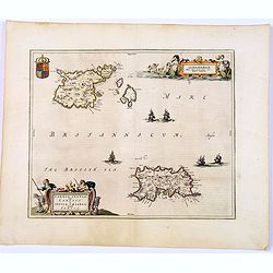
Sarnia insula vulgo Garnsey et Insula Caesarea. . . Garnsey. . .
Fine decorative map depicting the English Channel Islands of Jersey and Guernsey.Taken from Joan Blaeu's French edition Le Theatre du Monde, ou Nouvelle Atlas, Mise en l...
Date: Amsterdam, 1645
Selling price: ????
Please login to see price!
Sold in 2017
Glocestria Ducatus, Vulgo Glocestershire.
Double-page map of the county of Gloucester. Shows cities of Bristol, Tewkesbury, Cheltenham, and Stroud. Decorative title cartouche lower right corner of shepherds and t...
Date: Amsterdam, ca. 1645
Selling price: ????
Please login to see price!
Sold in 2020
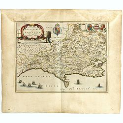
Comitatus Dorcestria, sive Dorsettia, Vulgo Anglice Dorset shire.
Double-page map of Dorsetshire county with decorative title and scale cartouches, six family coats of arms and two blank shields at bottom left.
Date: Amsterdam, ca. 1645
Selling price: ????
Please login to see price!
Sold in 2020
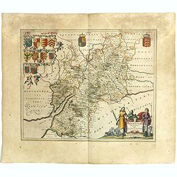
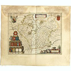
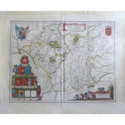
Wigorniensis Comitatus et Comitatus Warwicensis, nec non Coventrae libertas, Worcester, Warwic shire. And the Liberty of Coventre.
A double-page general map of the English counties of Warwickshire and Worcestershire with other towns such as Birmingham, Coventry, Leamington, Nuneaton, Kenilworth, Rugb...
Date: Amsterdam, ca. 1645
Selling price: ????
Please login to see price!
Sold in 2019
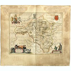
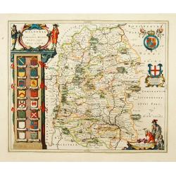
Leicestrensis Comitatus. Leicester shire.
Double-page map of the English county of Leicestershire. Decorative figurative and allegoric title cartouche with many heraldic family coat of arms on the bottom left por...
Date: Amsterdam, ca. 1645
Selling price: ????
Please login to see price!
Sold in 2020
Radnoria Comitatus. Radnor shire.
Double-page map of Radnorshire county, East of Wales. It is richly embellished with figurative title and scales cartouches, as well as coats of arms and royal arms.
Date: Amsterdam, ca. 1645
Selling price: ????
Please login to see price!
Sold in 2020
Denbigiensis Comitatus et Comitatus Flintensis, Denbigh et Flintshire.
Double-page map of Denbigshire and Flintshire, Wales with ornamental cartouches and armorials.
Date: Amsterdam, ca. 1645
Selling price: ????
Please login to see price!
Sold in 2020
Westmoria Comitatus: Anglice Westmorland.
A double-page map of Westmorland county in the northwest of England. Two very decorative cartouches with putti and figures display the title and scale in the two lower co...
Date: Amsterdam, 1645
Selling price: ????
Please login to see price!
Sold in 2020
Mervinia et Montgomeria Comitatus.
A decorative Welsh counties map by Jan Jansson, published in Amsterdam during the first half of the seventeenth century. It shows the mid-western Welsh counties of Merion...
Date: Amsterdam, ca 1645
Selling price: ????
Please login to see price!
Sold in 2020
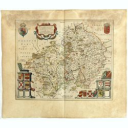
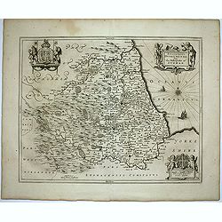
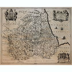
Comitatus Northumbria, Vernacule Northumberland. . .
A double-page map of Northumberland county with a decorative title cartouche and scale bar, eight family coats of arms and three blank shields at left. Superbly engraved ...
Date: Amsterdam, ca 1645
Selling price: ????
Please login to see price!
Sold in 2023
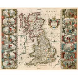
BRITTANNIA prout divisa fuit temporibus Anglo-Saxonum, ...
Decorative "carte ├Ā figures" map by Blaeu of the United Kingdom.
Date: Amsterdam, 1646
Selling price: ????
Please login to see price!
Sold in 2009
Episcopatus Dunelmensis. Vulgo The Bishoprike of Durham.
Fine double-page map of the bishopric and university city of Durham with two title and scale cartouches, and two impressive coat of arms upper left and right corners. Fre...
Date: Amsterdam, 1646
Selling price: ????
Please login to see price!
Sold in 2020
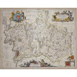
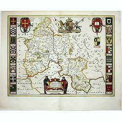
Middlesexiae cum Hertfordiae Comitatu: Midlesex & Hertfordshire.
Published in Novus Atlas sive Theatrum orbis Terrarum.The map has Decorative title and scale cartouches with peasants and livestock, upper right and lower centre respecti...
Date: Amsterdam, 1646
Selling price: ????
Please login to see price!
Sold
Episcopatus Dunelmensis. Vulgo The Bishoprike of Durham.
Exquisite black and white map of Durham with two fine title and scale cartouches, and two impressive coat of arms upper left and right corners.
Date: Amsterdam, 1646
Selling price: ????
Please login to see price!
Sold in 2019
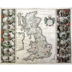
Britannia prout divisa fuit temporibus Anglo-Saxonum, presertim durante illorum Heptarchia.
An important and sought-after double-page map, decorated with the shields of the Saxon kingdoms, and 14 superb scenes of Anglo-Saxon history in full color. Finely engrave...
Date: Amsterdam, ca. 1646
Selling price: ????
Please login to see price!
Sold in 2019
Oxonium Comitatus, Vulgo Oxford shire.
Double-page map of the county of Oxford on the Thames River. This English county map is highly decorative with figurative title cartouche of two scholars. Royal arms and ...
Date: Amsterdam, 1647
Selling price: ????
Please login to see price!
Sold in 2012
'LEICESTRENSIS COMITATUS' Leicestershire
An attractive, finely engraved and hand colored copperplate 17th century map of Leicestershire. German text edition with two Royal crests, fine cartouches for title and s...
Date: Amsterdam, 1647
Selling price: ????
Please login to see price!
Sold in 2017
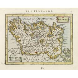
Irlandia.
Detailed miniature map of Ireland, from a German text edition of his Atlas Minor. Engraved by Petrus Kaerius.
Date: Amsterdam (1628) 1648
Selling price: ????
Please login to see price!
Sold
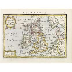
Anglia Scotia et Hibernia.
Detailed miniature map of the British Isles, from a German text edition of his Atlas Minor. Engraved by Petrus Kaerius.
Date: Amsterdam (1628) 1648
Selling price: ????
Please login to see price!
Sold
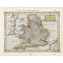
Anglia.
Detailed miniature map of England, from a German text edition of his Atlas Minor. Engraved by Petrus Kaerius.
Date: Amsterdam (1628) 1648
Selling price: ????
Please login to see price!
Sold
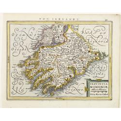
Provincia Momoniae.
Detailed miniature map of the southwestern most tip of Ireland, including the counties of Tipperary, Waterford, Limerick, Cork and Kerry. From a German text edition of hi...
Date: Amsterdam (1628) 1648
Selling price: ????
Please login to see price!
Sold
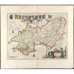
Penbrochia Comitatus et Comitatus Caermaridunum
Attractive map of the country of Pembrokeshire in UK by J. Blaeu. From a Dutch edition of "Atlas Maior" in beautiful color. br>With 13 coats of arms, one car...
Date: Amsterdam, 1648
Selling price: ????
Please login to see price!
Sold in 2008
HUNTINGDONENSIS COMITATUS, HUNTINGTON SHIRE
A highly attractive and finely copper plate engraved 17th century map This example bears French text to the verso and the usual excellent quality coloring.
Date: Amsterdam, 1648
Selling price: ????
Please login to see price!
Sold in 2013
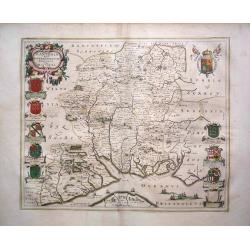
Hantonia Sive Southantonensis Comitatus Vulgo Hantshire
A very attractive Blaeu map of Hampshire. The map is embellished with royal coat of arms, and also of earls of Winchester and Southampton. Latin text on verso.
Date: Amsterdam, 1648
Selling price: ????
Please login to see price!
Sold in 2013
Britannia Prout Divisa Suit Temporibus Anglo-Saxonum.
An impressive and decorative historical map of the British Isles with the seven Anglo-Saxon kingdoms, Northumbria, Mercia, East Anglia, Essex, Kent, Sussex and Wessex. Ea...
Date: Amsterdam, 1648
Selling price: ????
Please login to see price!
Sold in 2014
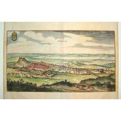
Edynburgum
A beautifully rendered 17th century view of Edinburgh. Provides excellent detail, with many of the town's key sites visible. The Scottish coat of arms is shown in the upp...
Date: Frankfurt, 1650
Selling price: ????
Please login to see price!
Sold
Wiltopnia sive comitatus Wiltoniensis, Anglis Wilshire.
A fine copy of this famous and decorative map of Wiltshire. 16 shields, two left blank underneath the decorated cartouche at top left. Two more shields at right, secondar...
Date: Amsterdam 1650
Selling price: ????
Please login to see price!
Sold
Essexia comitatus.
A fine copy of this famous and decorative map of Essex. Title banner, scale cartouche with three putti. Royal Arms, Arms of England and A panel displaying seven coats of ...
Date: Amsterdam 1650
Selling price: ????
Please login to see price!
Sold
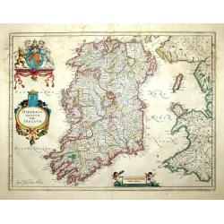
Hibernia regnum vulgo Ireland
A good and dark impression of a cornerstone map of Ireland, with three decorative cartouches in full original color.
Date: Amsterdam, 1650
Selling price: ????
Please login to see price!
Sold
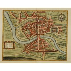
Brightstowe.
An very attractive town plan of Bristol with in the upper right corner coat of arms. Lower left a key to the principal buildings of the city.Brightstowe (meaning pleasant...
Date: Amsterdam 1650
Selling price: ????
Please login to see price!
Sold
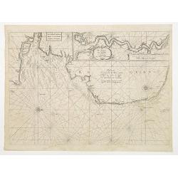
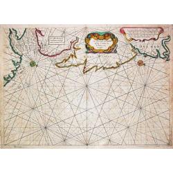
Pascaerte Vertoonende de Mont Vande Teemse en Voort de Custe van Engelandt tot Crammer.
Fine map depicting the English shores between Cromer in the Norfolk and North Foreland in Kent. West to the top.Additional title: Les Costes d?Engleterre depuis le Voorla...
Date: Amsterdam 1650
Selling price: ????
Please login to see price!
Sold
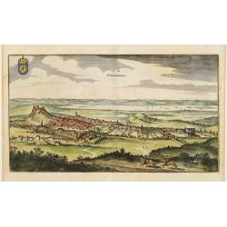
Edynburgum.
Detailed bird's-eye view of the town of Edenburg. From Merian's Theatrum Europaeum.
Date: Frankfurt 1650
Selling price: ????
Please login to see price!
Sold
![Lvnden [London]](/uploads/cache/11229-250x250.jpg)
Lvnden [London]
Decorative panoramic view London. With extensive shipping in river Themes. Very decorative and of the highest standing of engraving.
Date: Frankfurt 1650
Selling price: ????
Please login to see price!
Sold
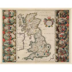
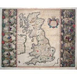
Britannia prout divisa suit temporibus Anglo-Saxonum, pr├”sertim durante illorum Heptarchia.
A fine copy of this famous and decorative map, depicting the ancient kingdoms of Britain, with two side panels. The left-hand border depicts the founders of each of the s...
Date: Amsterdam, 1650
Selling price: ????
Please login to see price!
Sold in 2009
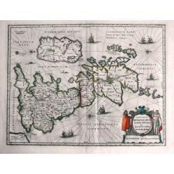
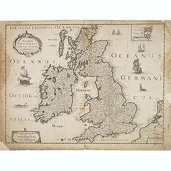
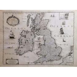
Insularum Britannicarum Acurata Delineatio ex Geographicis Conatibus Abraham Ortelii.
This is Jansson's historical map of the British Isles giving credit to Abraham Ortelius in the title. Engraved by Peter van den Keere. North is oriented to the right. H...
Date: Amsterdam, c1650
Selling price: ????
Please login to see price!
Sold in 2013
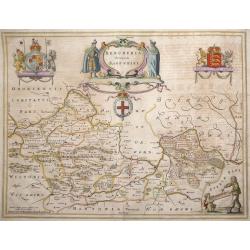
Bercheria vernacule. . . (Barkshire)
ŌĆśBercheria vernaculeŌĆÖ - Barkshire by Joannes Blaeu. A very decorative map, with armorials and escutcheons.
Date: Amsterdam, 1650
Selling price: ????
Please login to see price!
Sold in 2013
Novissima descriptio Angliae Scotiae et Hiberniae.
Uncommon map of Great Britain and Ireland.
Date: Paris, c. 1650
Selling price: ????
Please login to see price!
Sold in 2015
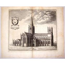
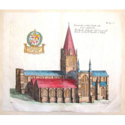
Herfordiensis Ecclesiae Cathedralis Ab Aquilone Prospectus.
Striking copper engraving of Herford Cathedral by Wenceslaus Hollar. It was created in about 1650 for Sir. W. Dugdale of England for his well known book featuring British...
Date: London, c1650
Selling price: ????
Please login to see price!
Sold in 2015
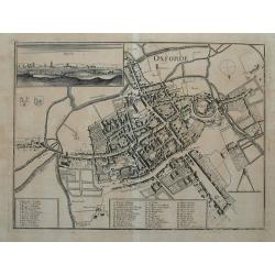
Oxforde.
Superbly detailed plan of Oxford with hundreds of tiny buildings, numerous fields, and rivers. With 48 places, streets, bridges, churches, and colleges identified through...
Date: Frankfurt, c1650
Selling price: ????
Please login to see price!
Sold in 2015
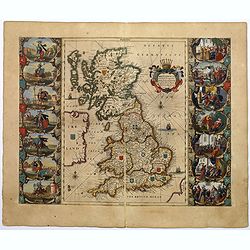
Britannia prout divisa suit temporibus Anglo-Saxonum, praesertim durante illorum Heptarchia.
A very decorative map of England, Scotland and Wales. Wales and Scotland have their own kingdoms, however, England is divided up into seven separate Saxon kingdoms.Northu...
Date: Amsterdam, ca 1650
Selling price: ????
Please login to see price!
Sold in 2018
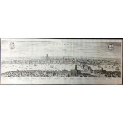
London.
A beautifully engraved panorama of London during the reign of James I which was based on an earlier Visscher engraving published in 1616.Merian's panorama shows London fi...
Date: London, 1650
Selling price: ????
Please login to see price!
Sold in 2019
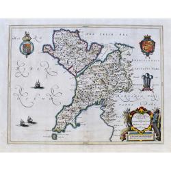
Comitatus Caernarvoniensis. . .
A fine Blaeu map of Caernarvonshire and Anglesey with present-day Gwynedd, including Bangor, Colwyn, Pwllheli, etc. Very detailed with many place names, hills, rivers, la...
Date: Amsterdam, ca 1650
Selling price: ????
Please login to see price!
Sold in 2020
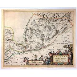
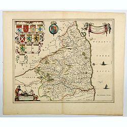
Lidelia Vel Lidisdalia Regio, Lidisdail.
A map of Liddesdale, a historic district of Scotland, bordering Teviotdale to the east, Annandale to the west, and Tweeddale to the north, with the English county of Cumb...
Date: Amsterdam, 1654
Selling price: ????
Please login to see price!
Sold in 2016
Lagenia; Anglis Leinster / The countie of Leinster.
An elegant map which includes the area westward from Dublin to the Shannon and from Waterford in the north to Drogheda. A decorative map with galleons in full sail in the...
Date: Amsterdam, 1654
Selling price: ????
Please login to see price!
Sold in 2018
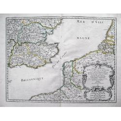
Anciens Royaumes de Kent, d'Essex, et de Sussex: ou sont Aujourdhuy les Comt├®s de Kent, d'Essex, Middlessex, et Hartford de Sussex, et Surrey. Avecq le Pas de Calais, et Partie des Cotes du Pays Bas, de Picardie, et Normandie.
Interesting map of the Strait of Dover / Pas de Calais. Shows the French coast from Fecamp, Dieppe, Boulogne, Calais; the Belgian Coast with Oostende, and the Dutch Coast...
Date: Paris, 1654
Selling price: ????
Please login to see price!
Sold in 2012
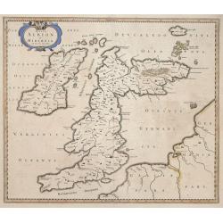
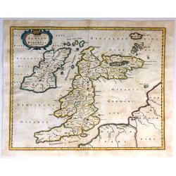
Insulae Albion et Hibernia cum minoribus adjacentibus.
This map of the British Isles during ancient times is based on the cartography of MercatorŌĆÖs Ptolemaic presentation of the British Isles and Ireland, The map delineates...
Date: Amsterdam, 1654
Selling price: ????
Please login to see price!
Sold in 2014
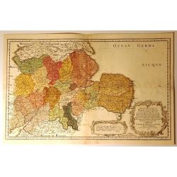
Anciens Royaumes de Mercie et East Angles. . .
Ancient Kingdoms of Mercia and East Anglia. This is a striking map showing the ancient Saxon kingdoms of Mercia and East Anglia including the counties and shires of Chest...
Date: Paris, 1654
Selling price: ????
Please login to see price!
Sold in 2017
Insulae Albion et Hibernia Cum Minoribus Adjacentibus.
This map of the British Isles during ancient times is based on the cartography of Mercator. The map delineates and names ancient regions via hand coloring and engraved li...
Date: Amsterdam, 1654
Selling price: ????
Please login to see price!
Sold in 2016
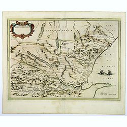
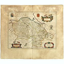
Southerlandia.
A map from the first comprehensive atlas of Scotland, published by Blaeu in 1654, after an earlier work of the region by Gordon. 'Southerlandia' is a highland region of n...
Date: Amsterdam, 1654
Selling price: ????
Please login to see price!
Sold in 2018
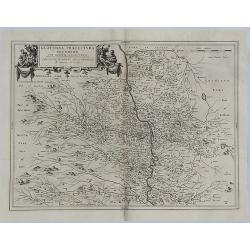
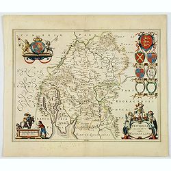
Glottiana Praefectura Inferior cum Baronia Glascuensi.
A fine map of the Glasgow region of Scotland. It extends from Glasgow to Lanark with Hamilton at its centre, and Kyle to Lothian. The map was drawn by Timothy Pont and su...
Date: Amsterdam, 1654
Selling price: ????
Please login to see price!
Sold in 2018
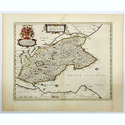
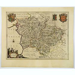
Fifae Vicecomitatus. The Sherifdome of Fyfe.
A decorative Scottish county map by Blaeu. It shows the whole Fife peninsula with Edinburgh at bottom of the map. Published in his Atlas Novus Vol. 5 in 1654, The map is ...
Date: Amsterdam, 1654
Selling price: ????
Please login to see price!
Sold in 2023
Vistus Insula, vulgo VII ST, cum aliis minoribus
This scarce map of Barra and North and South Uist in the Outer Hebrides of Scotland by Joan Blaeu was based on the surveys done by Timothy Pont some half-century earlier....
Date: Amsterdam, 1654
Selling price: ????
Please login to see price!
Sold in 2023
Novissima descriptio Angliae Scotiae et Hiberniae.
A striking and highly detailed copper engraved map of British Islands, including United Kingdom, Ireland and portions of Netherlands. The map gives several details concer...
Date: Paris, 1655
Selling price: ????
Please login to see price!
Sold in 2018
The North Prospect of ye Conuentuall Church of Christ in Oxford.
Hand-colored copper engraving of the Church of Christ in Oxford from Daniel King's "The Cathedrall & Conventuall Churches of England". King was a friend an...
Date: London, 1656
Selling price: ????
Please login to see price!
Sold in 2015
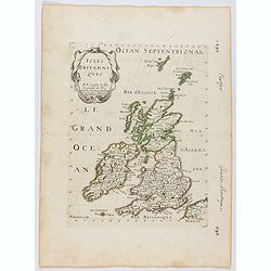
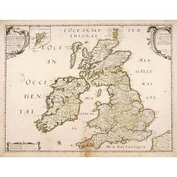
Isles Britanniques . . .
Map of Great Britain prepared by N.Sanson and published by Pierre Mariette. This is a reduced derivative of the famous Sanson map of 1650.Published in an early edition of...
Date: Paris, P. Mariette, 1656
Selling price: ????
Please login to see price!
Sold in 2025
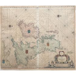
Pascaarte vant Canaal door Arnold Colom t Amsterdam op het Watter by de Nieuwe brugh inde Lichtende Colom.
This large folio, extremely decorative sea chart offered here is one of the earliest and rarest sea charts depicting the British Isles. It appeared in the famous Colom's...
Date: Amsterdam, 1656
Selling price: ????
Please login to see price!
Sold in 2022
Carte generale des Royaume d'Angleterre Escosse et Irlande..
Fine map of the British Isles, in a second state. The map was first published by Tavernier and later by Mariette. This edition carries the date 1640, and address of Pierr...
Date: Paris, 1640-1657
Selling price: ????
Please login to see price!
Sold in 2011
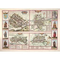
Galwaye, Dubline , Lymericke, and Corcke - Braun & Hogenberg, 1618.
Fine "carte ├Ā figures"- map with four Irish bird's-eye plans: Galway, Dublin, Limerick and Cork with left and right borders of costumed figures and top right v...
Date: Amsterdam, (1618) 1657
Selling price: ????
Please login to see price!
Sold in 2013
