Browse Listings in Europe > British Isles
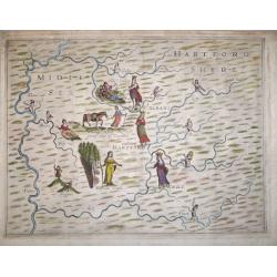
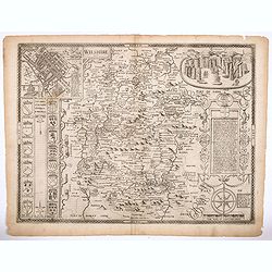
'Poly-Olbion' - Midle Sex Hartford Shyre.
A very decorative map of Middlesex and Hertfordshire, from Michael Drayton's fantastical "Poly-Olbion" or "Chorographical Description of all the Tracts, Ri...
Date: London, 1612
Selling price: ????
Please login to see price!
Sold in 2018
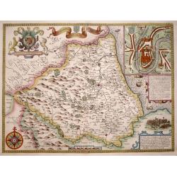
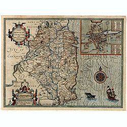
The Bishoprick and Citie of Durham.
A highly decorative and truly stunning 17th century map of the county of Durham by John Speed which was published in his "Theatre of the Empire of Great Britaine&quo...
Date: London, 1611-1612
Selling price: ????
Please login to see price!
Sold in 2014
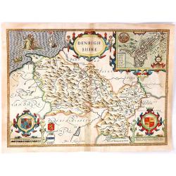
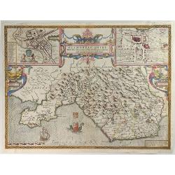
Denbighshire
A splendid antique county map of Denbighshire, located in the northwest corner of Wales from the "Theatre of Great Britaine" by John Speed, and published by J. ...
Date: London, 1612
Selling price: ????
Please login to see price!
Sold in 2016
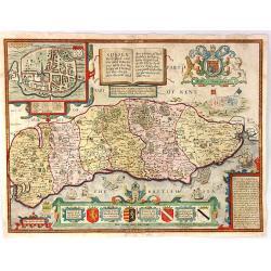
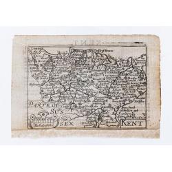
Sussex Described and divided into Rapes with the situation of Chichester the Chiefe citie thereof...
A splendid antique county map of Sussex from "Theatre of Great Britaine" by John Speed, published by J. Sudbury and George Humbell in 1612. (1st edition). The m...
Date: London, 1612
Selling price: ????
Please login to see price!
Sold in 2016
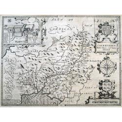
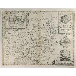
Caermarden Both Shyre and Towne described.
Highly decorative map of Carmarthenshire, Wales. With an inset plan of Caermarthen, with coat of arms, a large compass rose and the Prince of Wales feathers. Provides exc...
Date: London, 1612
Selling price: ????
Please login to see price!
Sold in 2016
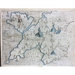
Carnarvanshyre / Merionethshyre.
An unusual antique map of Anglesey, Caernarvonshire and Merionethshire, engraved by William Hole for the "Poly- olbion" by Michael Drayton, published in 1612.Re...
Date: 1612
Selling price: ????
Please login to see price!
Sold in 2020
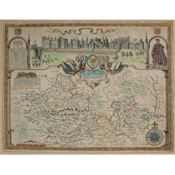
Barkshire Described.
Published in London by John Sudbury & George Humble, 1610-12 First Edition English text verso. With inset elevation of Windsor Castle. From Speed's atlas 'The Theatr...
Date: London 1610-1612
Selling price: ????
Please login to see price!
Sold in 2017
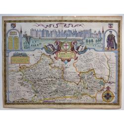
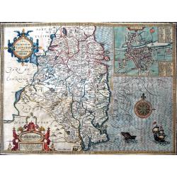
Berkshire Described.
A lovely map of Berkshire from the first Sudbury & Humble edition of John Speed’s “Theatre of the Empire of Great Britain”. The top of the map shows a panoramic...
Date: London, 1612
Selling price: ????
Please login to see price!
Sold in 2018
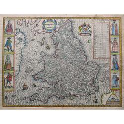
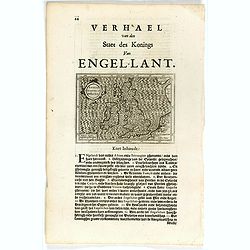
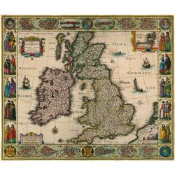
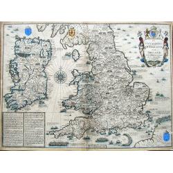
The Kingdome of England.
Rare first edition of Speed's carte-a-figures map engraved by Hondius and published John Sudbury & George Humble. This famous map of England & Wales is flanked by...
Date: London, ca. 1612
Selling price: ????
Please login to see price!
Sold in 2017
The countie of Leinster with the citie Dublin described.
Beautifully engraved map of eastern Ireland. With Lough Ree and Lough Derg, and Limerick as the most western point of the map. An inset plan shows on of the earliest prin...
Date: London, ca. 1612
Selling price: ????
Please login to see price!
Sold in 2019
Glamorgan Shyre with the Sittuations of the Chiefe Townd Cardyff and Ancient Landaffe Described.
A nice full color example of John Speed's map of the County of Glamorgan, in south Wales, including coats of arms and a detailed town plan of Cardiff and the town of Land...
Date: London, 1612
Selling price: ????
Please login to see price!
Sold in 2019
Caermarden both Shyre and Towne Described.
This is probably the most decorative map ever produced concerning the Welsh county of Caermarden (Carmarthenshire). It has an inset plan of Caermarthen, two cartouches w...
Date: London, 1612
Selling price: ????
Please login to see price!
Sold in 2019
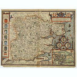
![Glocestershyre [with] Parte of Worcestershyre.](/uploads/cache/1120255-250x250.jpg)
Glocestershyre [with] Parte of Worcestershyre.
Double page map. Blank on verso. Decorative map of Gloucestershire adorned with numerous illustrations of allegorical figures. The Cotswalds are represented with the illu...
Date: [London, printed for M. Lownes, I.Browne, I. Helme, I. Busbie. 1612
Selling price: ????
Please login to see price!
Sold in 2020
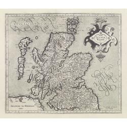
Scotia Regnum.
Detailed map of Scotland.Mercator was born in Rupelmonde in Flanders and studied in Louvain under Gemma Frisius, Dutch writer, astronomer and mathematician. The excellenc...
Date: Amsterdam, 1613
Selling price: ????
Please login to see price!
Sold
SCOTIAE REGNUM per Gerardum Mercatorem. (Scotland in Two Sheets)
This is an impressive large two-sheet map of Scotland. These two maps are not commonly available, particularly with both maps from the same atlas as in this example! T...
Date: Duisburg & then Amsterdam, (1595) 1613
Selling price: ????
Please login to see price!
Sold in 2011
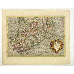
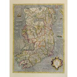
Irlandiae Regnum.
Fine map of southern part of Ireland.Mercator was born in Rupelmonde in Flanders and studied in Louvain under Gemma Frisius, Dutch writer, astronomer and mathematician. T...
Date: Amsterdam, c. 1613
Selling price: ????
Please login to see price!
Sold in 2012
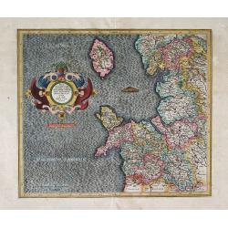
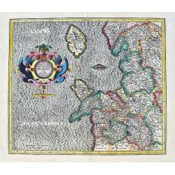
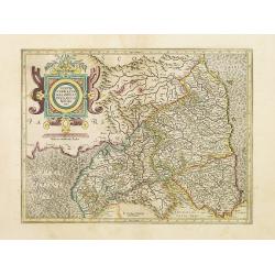
WEST MORLANDIA, LANCASTRIA, CESTRIA, CAERNARVAN, DENBIGH, FLINT, MERIONIDH, MONTGOMERY, SALOPIA Cum insulis MANIA ET ANGLESEY, Per Gerardum Mercatorem.
A fine, early decorative map by Gerard Mercator of northwest England. There is great clarity in the placement and list of numerous cities and towns on the map. At the l...
Date: Duisburg and then Amsterdam, (1595-1602) 1613
Selling price: ????
Please login to see price!
Sold in 2013
West Morlandia, Lancastria, Cestria . . .
A fantastic map showing northern Wales with Anglesey, the Isle of Man, and parts of England including the cities of Liverpool, Manchester, Chester, Preston, Kendal, and m...
Date: Amsterdam, ca. 1613
Selling price: ????
Please login to see price!
Sold in 2020
Buckinghamshire.
An attractive map of Buckinghamshire from the "Theatre of Great Britaine" by John Speed, published by George Humbell in 1614. Inset town plans of Buckingham and...
Date: London, 1614
Selling price: ????
Please login to see price!
Sold in 2016
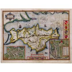
Isle of Wight.
Striking map of The Isle of Wight, by John Speed, along with town plans of Newport and Southampton.
Date: London, ca. 1615
Selling price: ????
Please login to see price!
Sold in 2010
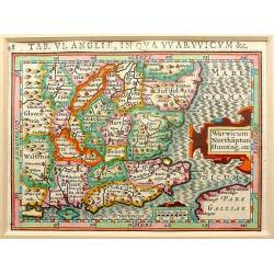
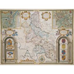
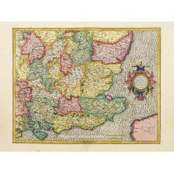
Warwicum Northapton Hunting.
Copper-engraving by P. Bertius published by J. Hondius, 1616. With small ornamental cartouche and "Miliaria Anglica" of Suffolk, Essex, Kent, East and West Suss...
Date: Amsterdam, 1616
Selling price: ????
Please login to see price!
Sold in 2012
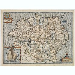
The province of Ulster described.
A most decorative map of the County of Ulster in Northern Ireland. One of four maps in this auction of the Irish provinces included in Speed’s atlas, it contains an ins...
Date: London, 1610 - 1616
Selling price: ????
Please login to see price!
Sold in 2013
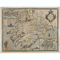
The province of Mounster.
A most decorative map of the Irish province of Munster, located in the southwest of the island. One of four maps in this auction of the Irish provinces included in Speedâ...
Date: London, 1610 - 1616
Selling price: ????
Please login to see price!
Sold in 2013
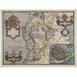
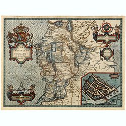
The province of Connaugh with the Citie of Galwaye Described.
A most decorative map of the Irish province of Connaught. The sea is decorated with ships and sea monsters, including one being ridden by an Irish bard playing a harp. On...
Date: London, 1610 - 1616
Selling price: ????
Please login to see price!
Sold in 2013
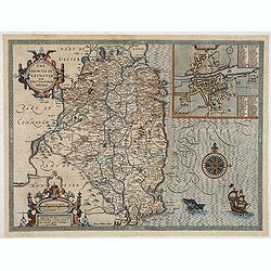
The countie of Leinster with the Citie Dublin Described.
A most decorative map of the Irish County of Leinster, which includes this remarkable early plan of Dublin, a sea monster, sailing ship and decorative compass rose. One o...
Date: London, 1610 - 1616
Selling price: ????
Please login to see price!
Sold in 2013
The countie of Leinster with the Citie Dublin Described.
A most decorative map of the Irish County of Leinster, which includes this remarkable early plan of Dublin, a sea monster, sailing ship and decorative compass rose. One o...
Date: London, 1610 - 1616
Selling price: ????
Please login to see price!
Sold in 2015
The province of Connaugh with the Citie of Galwaye Described.
A most decorative map of the Irish province of Connaught. The sea is decorated with ships and sea monsters, including one being ridden by an Irish bard playing a harp. On...
Date: London, 1610 - 1616
Selling price: ????
Please login to see price!
Sold in 2015
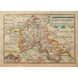
Provincia Oxoniensis/ Oxford-Shire.
An very decorative map of the county from an early edition of Speed's atlas, "Theatre of Great Britaine", with inset plan of Oxford, scale bar within a pair of ...
Date: London, 1616
Selling price: ????
Please login to see price!
Sold in 2016
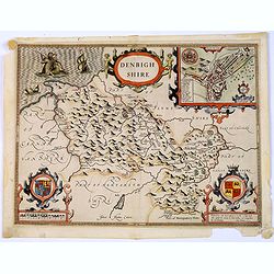
Denbighshire.
A highly decorative map of the county of Denbighshire, located in the northwest corner of Wale from the uncommon and early Latin edition. The upper right corner inset con...
Date: London, 1616
Selling price: ????
Please login to see price!
Sold in 2018
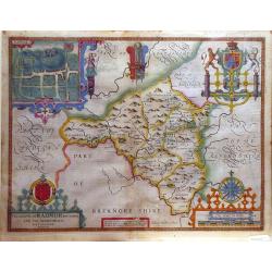
The Countie of Radnor.
A decorative county map from John Speed's atlas, illustrated with a town map of Radnor.
Date: London, 1618
Selling price: ????
Please login to see price!
Sold in 2010
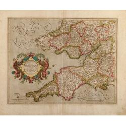
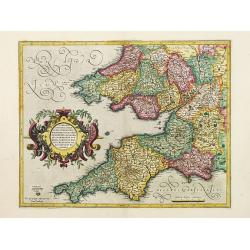
Cornubia, Devonia, Somersetus, Dorcestria, Wiltonia, Glocestria Monumetha, Glamorgan, Caermarden, Penbrok, Cardigan, Radnor, Breknoke, Herefordia, & Wigornia
Original colored map of south west England and south Wales of Gerard Mercator. From a Latin edition of the Mercator Hondius Atlases.
Date: Amsterdam, 1619
Selling price: ????
Please login to see price!
Sold in 2009
Cornubia, Devonia, Somersetus, Dorcestria, Wiltonia, Glocestria, Monumetha, Glamorgan,..
southwest England and southern Wales. French text on verso.
Date: Amsterdam, 1619
Selling price: ????
Please login to see price!
Sold in 2017
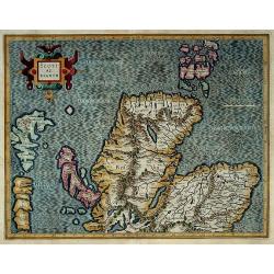
![[Untitled map of Southern Scotland].](/uploads/cache/44629-250x250.jpg)
[Untitled map of Southern Scotland].
An attractive early seventeenth century map of southern Scotland by Hondius. Some of the Inner & Outer Hebridean Isles are shown Skye, Mull, Arran, Mull, Egge, Islay,...
Date: Amsterdam, ca 1619
Selling price: ????
Please login to see price!
Sold in 2019
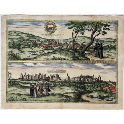
Oxonium - Vindesorium
Oxford and Windsor Castle, by Georg Braun and Frans Hogenberg, after design by G. Hoefnagel.Titles at top centre on both views: 'Oxonium Nobile Anglie Oppidum ... ' / Vin...
Date: ca. 1620
Selling price: ????
Please login to see price!
Sold in 2022
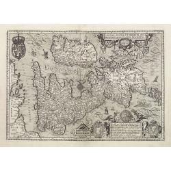
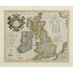
Angliae, Scotiae, et Hiberniae, sive Britannicar : Insularum descriptio.
A rare and ornate map with inset portraits of James First, Henry Prince of Wales Princess Anne of Denmark.Janssonius acquired the copperplate of van den Keere's 1604 Brit...
Date: Amsterdam 1621
Selling price: ????
Please login to see price!
Sold
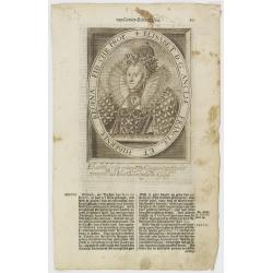
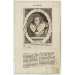
Elisabet D. G. Angliae, Franciae, Et Hiberniae, Regina, Fid. Chr. Prop.
The engraving depicts a half length oval portrait of Elisabeth I.Nicolaes de Clerck (de Klerc) was active as engraver and publisher in Delft from 1599-1621.Included in th...
Date: Amsterdam, Cloppenburch, 1621
Selling price: ????
Please login to see price!
Sold
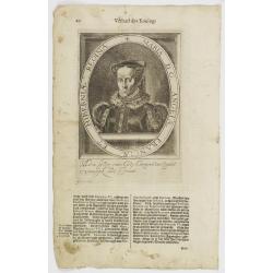
Maria D. G. Angliae Franciae Et Hiberniae Regina.
The engraving depicts a half length oval portrait of Mary Tudor.Nicolaes de Clerck (de Klerc) was active as engraver and publisher in Delft from 1599-1621.Included in the...
Date: Amsterdam, Cloppenburch, 1621
Selling price: ????
Please login to see price!
Sold
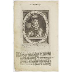
Henricus VII D.G. Angliae Franciae Et Hiberniae Rex.
The engraving depicts a half length oval portrait of Henry VII.Nicolaes de Clerck (de Klerc) was active as engraver and publisher in Delft from 1599-1621.Included in the ...
Date: Amsterdam, Cloppenburch, 1621
Selling price: ????
Please login to see price!
Sold
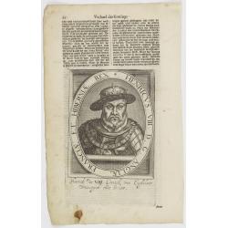
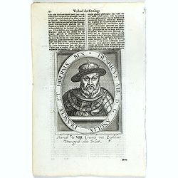
Henricus VIII D.G. Angliae Franciae Et Hiberniae Rex.
The engraving depicts a half length oval portrait of Henry VIII.Nicolaes de Clerck (de Klerc) was active as engraver and publisher in Delft from 1599-1621.Included in the...
Date: Amsterdam, Cloppenburch, 1621
Selling price: ????
Please login to see price!
Sold
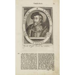
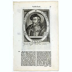
Iacobus V. Dei Gratia, Rex Scotorum.
The engraving depicts a half length oval portrait of James V of Scotland.Nicolaes de Clerck (de Klerc) was active as engraver and publisher in Delft from 1599-1621.Includ...
Date: Amsterdam, Cloppenburch, 1621
Selling price: ????
Please login to see price!
Sold in 2009
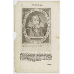
Iacobus I. D. G. Magnae-Brittanniae, Franciae Et Hiberniae Rex. Def. Fid.
The engraving depicts a half length oval portrait of James I of England.Nicolaes de Clerck (de Klerc) was active as engraver and publisher in Delft from 1599-1621.Include...
Date: Amsterdam, Cloppenburch, 1621
Selling price: ????
Please login to see price!
Sold
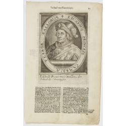
Eduardus Princeps Cambriae, Terror Gallorum.
The engraving depicts a half length oval portrait of Edward Prince of Wales.Nicolaes de Clerck (de Klerc) was active as engraver and publisher in Delft from 1599-1621.Inc...
Date: Amsterdam, Cloppenburch, 1621
Selling price: ????
Please login to see price!
Sold in 2018
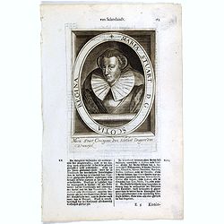
Maria Stuart. D. G. Scotia Regina.
The engraving depicts a half length oval portrait of Mary Stuart.Nicolaes de Clerck (de Klerc) was active as engraver and publisher in Delft from 1599-1621.Included in th...
Date: Amsterdam, Cloppenburch, 1621
Selling price: ????
Please login to see price!
Sold

Anglia Scotia et Hibernia.
Small map of Great Britain and Ireland, surrounded by text in Dutch.Nicolaes de Clerck (de Klerc) was active as engraver and publisher in Delft from 1599-1621.Included in...
Date: Amsterdam, Cloppenburch, 1621
Selling price: ????
Please login to see price!
Sold in 2010
Anglia Scotia et Hibernia.
Small map of Great Britain and Ireland, surrounded by text in Dutch.Nicolaes de Clerck (de Klerc) was active as engraver and publisher in Delft from 1599-1621.Included in...
Date: Amsterdam, Cloppenburch, 1621
Selling price: ????
Please login to see price!
Sold in 2017
Iacobus V. Dei Gratia, Rex Scotorum.
The engraving depicts a half length oval portrait of James V of Scotland.Nicolaes de Clerck (de Klerc) was active as engraver and publisher in Delft from 1599-1621.Includ...
Date: Amsterdam, Cloppenburch, 1621
Selling price: ????
Please login to see price!
Sold in 2016
Maria Stuart. D. G. Scotia Regina.
The engraving depicts a half length oval portrait of Mary, Queen of Scots (1542 – 1587), also known as Mary Stuart or Mary I of Scotland, was Queen of Scotland from 14 ...
Date: Amsterdam, Cloppenburch, 1621
Selling price: ????
Please login to see price!
Sold in 2016
Iacobus I. D. G. Magnae-Brittanniae, Franciae Et Hiberniae Rex. Def. Fid.
The engraving depicts a half length oval portrait of James VI and I (1566 – 1625) was King of Scotland as James VI, and King of England and King of Ireland as James I. ...
Date: Amsterdam, Cloppenburch, 1621
Selling price: ????
Please login to see price!
Sold in 2016
Maria D. G. Angliae Franciae Et Hiberniae Regina.
The engraving depicts a half length oval portrait of Mary I (1516 – 1558), Queen of England, unpleasantly remembered as "the Bloody Mary" on account of the re...
Date: Amsterdam, Cloppenburch, 1621
Selling price: ????
Please login to see price!
Sold in 2016
Elisabet D. G. Angliae, Franciae, Et Hiberniae, Regina, Fid. Chr. Prop.
The engraving depicts a half length oval portrait of Elizabeth I (1533 – 1603) was Queen of England and Ireland from 17 November 1558 until her death. Sometimes called ...
Date: Amsterdam, Cloppenburch, 1621
Selling price: ????
Please login to see price!
Sold in 2016
Henricus VII D.G. Angliae Franciae Et Hiberniae Rex.
The engraving depicts a half length oval portrait of Henry VII, known before accession as Henry Tudor, 2nd Earl of Richmond (1457 – 1509), was King of England after sei...
Date: Amsterdam, Cloppenburch, 1621
Selling price: ????
Please login to see price!
Sold in 2016
Henricus VIII D.G. Angliae Franciae Et Hiberniae Rex.
The engraving depicts a half length oval portrait of Henry VIII (1491 – 1547) was King of England from 21 April 1509 until his death. He was the first English King of I...
Date: Amsterdam, Cloppenburch, 1621
Selling price: ????
Please login to see price!
Sold in 2016
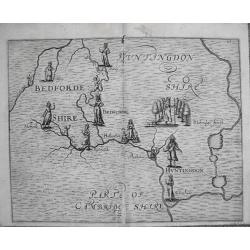
Polyolbion Bedfordshire & parts of Cambridgeshire.
Original 1622 map by Micheal Draytons Polyolbion Bedfordshire, Huntingdonshire and parts of Cambridgeshire c1622, only printed in the 1622 edition.Michael Drayton, a frie...
Date: London, 1622
Selling price: ????
Please login to see price!
Sold in 2012
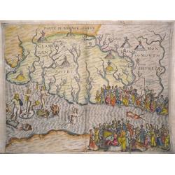
Poly-Olbion Glamorgan, Monmouthshire, Brecknockshire, Somerset. And the Severn Estuary.
The most decorative map from Drayton's fantastical 'Poly-Olbion' Engraved by William Hole for the 1622 edition of Poly-Olbion the area of Glamorgan, Monmouthshire, Brekno...
Date: London, 1622
Selling price: ????
Please login to see price!
Sold in 2014
![Somersetshere [with] Wiltshere.](/uploads/cache/1134151-250x250.jpg)
Somersetshere [with] Wiltshere.
A most decorative map of Somerset and Wiltshire. The main towns of the region - Bristol, Bath and Salisbury - are represented with standing female figures. Numerous other...
Date: London, printed by Iohn Marriott, Iohn Grismand, And Thomas Dewe. 1622
Selling price: ????
Please login to see price!
Sold in 2020
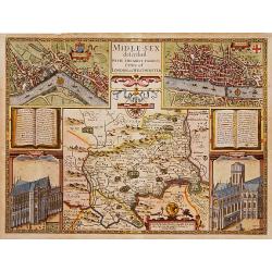
Middle-Sex described with the most famous cities of London and Westminster.
One of the most famous and sought-after of Speed's County maps. The County of Middlesex surrounded by a splendid border incorporating a plan of Westminster and London. In...
Date: London 1610-1623
Selling price: ????
Please login to see price!
Sold
Tabula Magnae Britanniae continens Angliam Scotiam et Hiberniam.
A very rare and decorative carte-Ă -figures map in a first state. Prof. Schilder locates only 8 other copies !.Interestingly, the map has extensive contemporary annotatio...
Date: Amsterdam, 1625
Selling price: ????
Please login to see price!
Sold in 2010
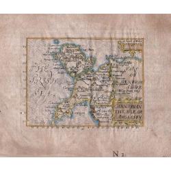
Carnarvan The Isle of Anglesey.
An extremely rare and sought-after miniature map of the county of Carnarvon and the Island of Anglesey from John Bill's "The Abridgement Of Camden's Britania ...&quo...
Date: London, 1626
Selling price: ????
Please login to see price!
Sold in 2016
Angliae Scotiae et Hiberniae sive Britannicarum Insularum &
Uncommon map of England, Scotland and Ireland, engraved by David Custos.
Date: Augsburg 1627
Selling price: ????
Please login to see price!
Sold
Hartforde Shire (Hertfordshire).
Fine miniature map of Hertfordshire by Pieter Van Den Keere. An attractive 17th Century map of Hertfordshire that was originally engraved between 1599 and 1605. Origina...
Date: London, George Humble, 1627
Selling price: ????
Please login to see price!
Sold in 2012
Oxfordshire.
Fine miniature map of Oxfordshire by Pieter Van Den Keere. An attractive 17th Century map of Oxfordshire that was originally engraved between 1599 and 1605. Original copp...
Date: London, George Humble, 1627
Selling price: ????
Please login to see price!
Sold in 2014
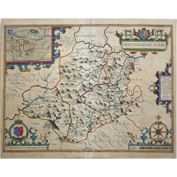
MONTGOMERY SHIRE.
An early decorative engraved 17th century map of the Welsh county of Montgomeryshire published in London and bearing the imprint of the publishers John Sudbury and George...
Date: London, 1627
Selling price: ????
Please login to see price!
Sold in 2017
The Invasions of England and Ireland with al their Civill Wars Since the Conquest.
A fantastic map of England, Wales and Ireland that illustrates all the notable battles since the Norman Conquest (including Hastings in 1066, Bosworth Field in 1485 and F...
Date: London, ca. 1627
Selling price: ????
Please login to see price!
Sold in 2019
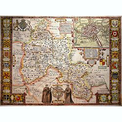
Essex, divided into Hundreds, with the most ancient and fayre Towne Colchester described. . .
A highly decorative and truly stunning 17th century map of Essex by the renowned English cartographer John Speed which was published in his Theatre of the Empire of Great...
Date: London, 1627
Selling price: ????
Please login to see price!
Sold in 2020
Kent.
Miniature county map of Kent. Text on verso.
Date: London, George Humble, 1627
Selling price: ????
Please login to see price!
Sold in 2020
Wiltshire.
All the undoubted artistry and skill of the English cartographer John Speed. Is on display with his rendition of this English County map of Wiltshire. There are beautiful...
Date: London, 1627
Selling price: ????
Please login to see price!
Sold in 2021
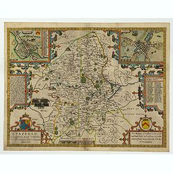
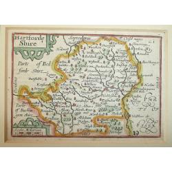
Stafford Countie and Towne with the ancient Citie Lichfield described. . .
A beautiful early edition John Speed's map of Staffordshire. As well as the county itself, the map boasts all manor of embellishments and decoration; a pair of wonderful...
Date: London, 1612 - 1627
Selling price: ????
Please login to see price!
Sold in 2022
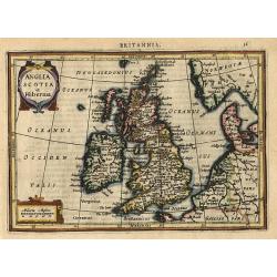
Anglia Scotia et Hibernia.
Nice map of the British Isles and Ireland showing the major cities. Large strapwork title cartouche. Latin text on verso.
Date: Amsterdam 1628
Selling price: ????
Please login to see price!
Sold
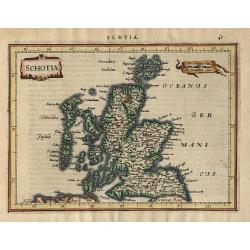
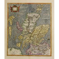
Schotia
Charming small map of Scotland decorated with a strapwork title cartouche. Latin text on verso.
Date: Amsterdam 1628
Selling price: ????
Please login to see price!
Sold
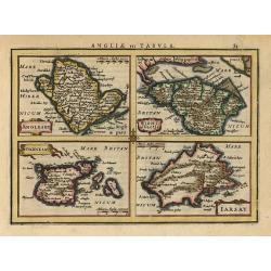
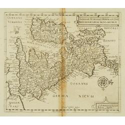
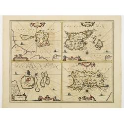
Anglesey, Wight, Garnesey, Iarsay.
This is a reduced version of Mercator's folio map with four maps on one sheet depicting the English islands of Jersey, Guernsey, Wright and Alderney. Each map is embellis...
Date: Amsterdam 1628
Selling price: ????
Please login to see price!
Sold
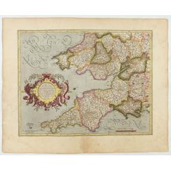
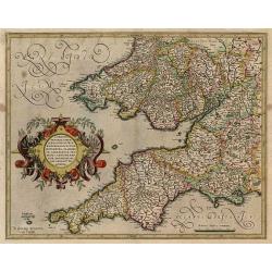
Cornubia, Devonia, Somersetus, . . .
A very nice map showing the south-western part of England. Mercator was born in Rupelmonde in Flanders and studied in Louvain under Gemma Frisius, Dutch writer, astronome...
Date: Amsterdam, 1630
Selling price: ????
Please login to see price!
Sold in 2025
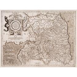
Northumbria, Cumberlandia et Dunelmensis Episcopatus.
Showing the most northern part of England.
Date: Amsterdam 1630
Selling price: ????
Please login to see price!
Sold
Cornubia, Devonia, Somersetus,..
A very nice map showing the south-western part of England. Mercator was born in Rupelmonde in Flanders and studied in Louvain under Gemma Frisius, Dutch writer, astronome...
Date: Amsterdam 1630
Selling price: ????
Please login to see price!
Sold
Warwicum..
Nice map of south-eastern England. Includes London, Salisbury, Oxford, Cambridge, Leicester and Norwich and the Isle of Wight. Strapwork title cartouche and scale of mile...
Date: Amsterdam 1630
Selling price: ????
Please login to see price!
Sold
Northumbria, Cumberlandia et Dunelmensis Episcopatus.
Showing the most northern part of England.Mercator was born in Rupelmonde in Flanders and studied in Louvain under Gemma Frisius, Dutch writer, astronomer and mathematici...
Date: Amsterdam 1630
Selling price: ????
Please login to see price!
Sold
West Morlandia, Lancastria..
Showing the north-western part of England, including the Island of Man.Mercator was born in Rupelmonde in Flanders and studied in Louvain under Gemma Frisius, Dutch write...
Date: Amsterdam 1630
Selling price: ????
Please login to see price!
Sold
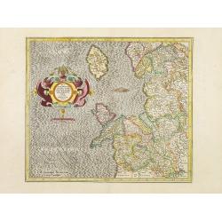
Holy Iland. Garnsey. Farne. Iarsey.
Showing the islands in the Channel.Mercator was born in Rupelmonde in Flanders and studied in Louvain under Gemma Frisius, Dutch writer, astronomer and mathematician. The...
Date: Amsterdam 1630
Selling price: ????
Please login to see price!
Sold in 2009
Scotiae regnum.
Detailed map of Northern part of Scotland, made of 2 maps pasted together.Mercator was born in Rupelmonde in Flanders and studied in Louvain under Gemma Frisius, Dutch wr...
Date: Amsterdam 1630
Selling price: ????
Please login to see price!
Sold
Irlandiae Regnum.
A very nice map from Ireland, made of 2 maps pasted together.Mercator was born in Rupelmonde in Flanders and studied in Louvain under Gemma Frisius, Dutch writer, astrono...
Date: Amsterdam 1630
Selling price: ????
Please login to see price!
Sold
Anglia, Scotia et Hibernia.
Early map of the British Isles. Mercator used the maps of England and Wales from Saxton, Ireland partly from Nowell-Hondius and Scotland from his own map of 1564. This wa...
Date: Amsterdam 1630
Selling price: ????
Please login to see price!
Sold
