Browse Listings in Europe > British Isles > Scotland / Wales
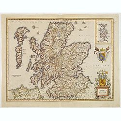
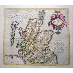
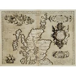
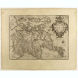
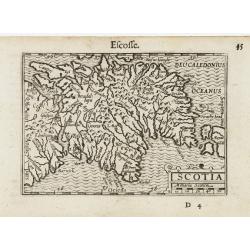
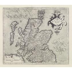
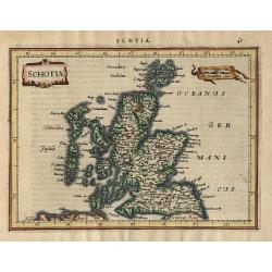
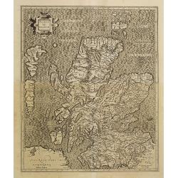
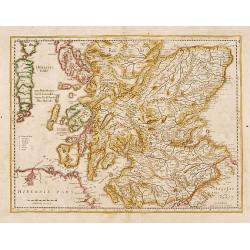
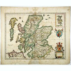
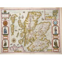
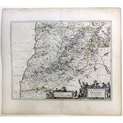
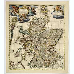
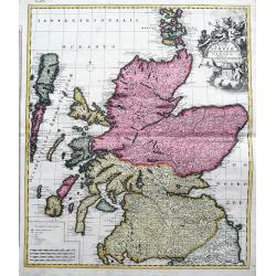
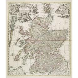
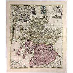
Scotia Regnum.
A attractive example of this fine map of Scotland.
Date: Amsterdam, ca.165
Selling price: ????
Please login to see price!
Sold in 2013
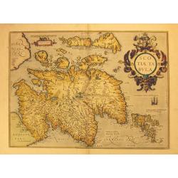
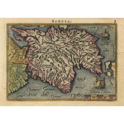
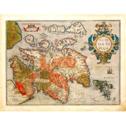
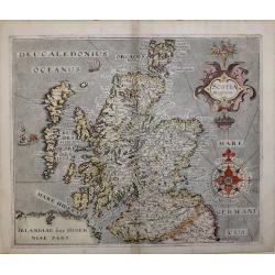
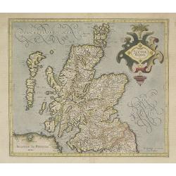
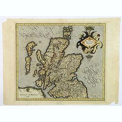
Scotiae Tabula.
Original old colored map of Scotland by A. Ortelius with north to the right of the plate. With one large cartouche, one sailing ship and a sea monster. From the 1573 Dutc...
Date: Antwerp, 1573
Selling price: ????
Please login to see price!
Sold in 2012
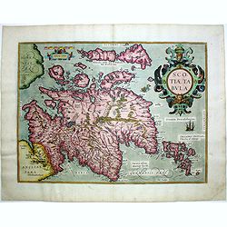
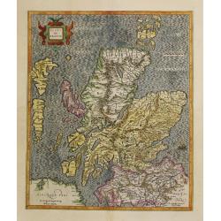
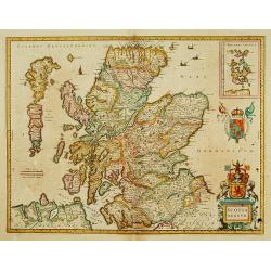
Scotiae tabula.
Very fine general map of Scotland with north to right of page. Derived from Mercator's 1564 map of the British Isles in 8 sheets.
Date: Antwerp, 1574
Selling price: ????
Please login to see price!
Sold in 2016
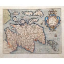
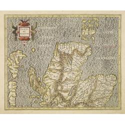
Scotiae Tabula.
From the Theatrum Orbis Terrarum, 1579. A fine map of Scotland with north to the right of the page. Ortelius derived this map from Mercator's 1564 map of the British Isle...
Date: Antwerp, 1579
Selling price: ????
Please login to see price!
Sold in 2018
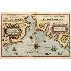
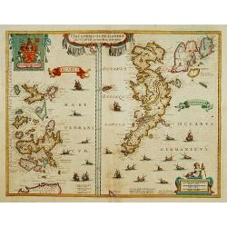
Beschrijvinge van een deel vann Schottlandt van Bambourg tot Aberdein. . .
A detailed chart of the coast of Scotland with Aberdeen. Decorated by a colorful title cartouche and scale cartouche, one compass rose, several vessels and sea monsters. ...
Date: Leiden, Plantijn, 1585
Selling price: ????
Please login to see price!
Sold in 2008
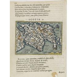
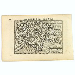
Scotia 7.
A page of printed text in Latin with a fine general map of Scotland. Prepared by Hugo Favolius (1523-1585), who was a Dutch poet, doctor and traveler, born in Middelburg....
Date: Antwerp, Plantin, 1585
Selling price: ????
Please login to see price!
Sold in 2009
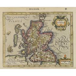
Scotia Regnum.
Printed in Duisberg 1587.
Date: Duisberg, 1587
Selling price: ????
Please login to see price!
Sold in 2014
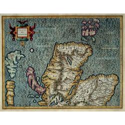
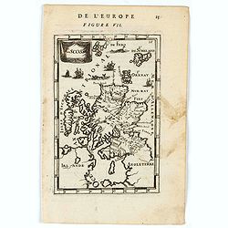
Scotia
Miniature map covering the northern part of England and Scotland. French text on verso. This map is oriented with north to the right. The map is beautifully engraved with...
Date: Antwerp, 1588
Selling price: ????
Please login to see price!
Sold
Britannicarum Insularum Vetus Descriptio.
Scarce. The upper sheet of a two-sheet map which was issued with the Parergon 1590 and repeated only in the Parergon 1591 and Theatrum 1592 (as present). According to Mar...
Date: Antwerp 1592
Selling price: ????
Please login to see price!
Sold
Scotiae Tabula.
From the Theatrum Orbis Terrarum, 1592.A fine general map of Scotland with north to the right of the page.Ortelius derived this map from Mercator's 1564 map of the Britis...
Date: Antwerp, 1592
Selling price: ????
Please login to see price!
Sold
Scotiae Tabula.
Scarce map of Scotland based on Ortelius. North orientated to the right. Very detailed with many place names. Decorated with sailings ships, a fox holding dividers above ...
Date: Cologne, 1592
Selling price: ????
Please login to see price!
Sold in 2011
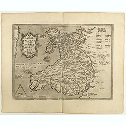
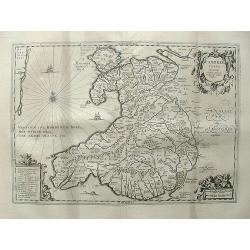
Cambriae Typus.
Ancient map of Wales, prepared by Humphrey Lhuyd. With fine cartouche, part of a compass-rose and a sea monster.Dare to go in Black. All early maps are printed in black a...
Date: Antwerp, 1598
Selling price: ????
Please login to see price!
Sold in 2018
Scotiae tabula.
Fine general map of Scotland with north to right of page. Derived from Mercator's 1564 map of the British Isles in 8 sheets.Dare to go in Black. All early maps are printe...
Date: Anwerp, 1598
Selling price: ????
Please login to see price!
Sold in 2018
Scotia.
An attractive miniature map of Scotland, published by Petrus Bertius, in Amsterdam at the beginning of the seventeenth century.Scotland is seen 'lying on its back' , as n...
Date: Amsterdam, 1606
Selling price: ????
Please login to see price!
Sold in 2020
![[Pict warrior holding a head].](/uploads/cache/39409-250x250.jpg)
[Pict warrior holding a head].
A marvellous print by de Bry of a Pict (Celtic / Scottish) warrior holding the head (dripping blood) of a defeated opponent. His nude body is stained and painted, much li...
Date: Frankfurt, 1607
Selling price: ????
Please login to see price!
Sold in 2017
Scotia.
Map of the Scotland from the first French-text edition of Jodocus Hondius'' Atlas Minor.Shortly after the publication of the big folio-atlases the need was apparently fel...
Date: Amsterdam, 1608
Selling price: ????
Please login to see price!
Sold in 2008
Scotiae Tabula. III.
Map depicting the northern part of Scotland. From the first French-text edition of Jodocus Hondius'' Atlas Minor.Shortly after the publication of the big folio-atlases th...
Date: Amsterdam, 1608
Selling price: ????
Please login to see price!
Sold in 2008
Scotia.
A miniature map of Scotland. Fine cartouche.First published in 1598 in his Caert-Thresoor, the plates were executed by the most famous engravers in Amsterdam, including P...
Date: Amsterdam/Frankfurt 1609
Selling price: ????
Please login to see price!
Sold
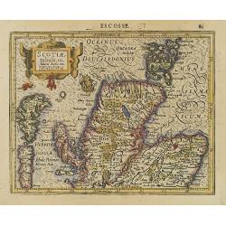
SCOTIA REGNUM
Second state map of Scotland 'SCOTIA REGNUM' By William Hole based on Christopher Saxton’s map of 1579, signed in the plate.A very attractive and decorative early 17th ...
Date: London, 1610
Selling price: ????
Please login to see price!
Sold in 2016
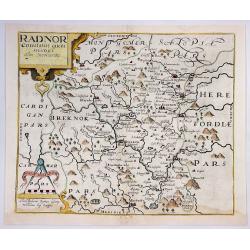
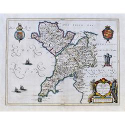
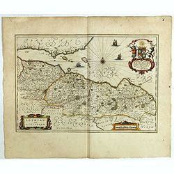
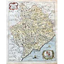
Radnor Comitatus Quem Silvres.
A decorative map of the Welsh county of Radnorshire, in Mid-Wales, engraved by William Kip, after Christopher Saxton, for the second English edition of Camden's 'Britanni...
Date: London, 1610
Selling price: ????
Please login to see price!
Sold in 2018
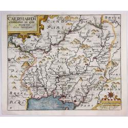
Caermardt Comitatus in Quo Dimetae.
A decorative map of the Welsh county of Caermarthen, in Wales, engraved by William Kip, after Christopher Saxton, for the second English edition of Camden's 'Britannia', ...
Date: London, 1610
Selling price: ????
Please login to see price!
Sold in 2017
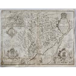
The Countye of Monmouth. . .
A beautiful Welsh county map of Monmouth Shire; part of the renowned “Theatre of the Empire of Great Britaine” by English cartographer John Speed. The copper plates w...
Date: London, ca. 1610
Selling price: ????
Please login to see price!
Sold in 2019
Scotia Regnum.
Detailed map of Scotland.Mercator was born in Rupelmonde in Flanders and studied in Louvain under Gemma Frisius, Dutch writer, astronomer and mathematician. The excellenc...
Date: Amsterdam, 1613
Selling price: ????
Please login to see price!
Sold
SCOTIAE REGNUM per Gerardum Mercatorem. (Scotland in Two Sheets)
This is an impressive large two-sheet map of Scotland. These two maps are not commonly available, particularly with both maps from the same atlas as in this example! T...
Date: Duisburg & then Amsterdam, (1595) 1613
Selling price: ????
Please login to see price!
Sold in 2011
![[Untitled map of Southern Scotland].](/uploads/cache/44629-250x250.jpg)
[Untitled map of Southern Scotland].
An attractive early seventeenth century map of southern Scotland by Hondius. Some of the Inner & Outer Hebridean Isles are shown Skye, Mull, Arran, Mull, Egge, Islay,...
Date: Amsterdam, ca 1619
Selling price: ????
Please login to see price!
Sold in 2019
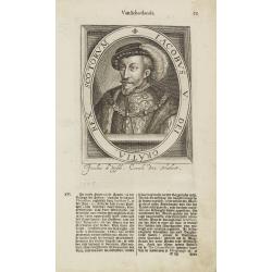
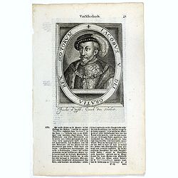
Iacobus V. Dei Gratia, Rex Scotorum.
The engraving depicts a half length oval portrait of James V of Scotland.Nicolaes de Clerck (de Klerc) was active as engraver and publisher in Delft from 1599-1621.Includ...
Date: Amsterdam, Cloppenburch, 1621
Selling price: ????
Please login to see price!
Sold in 2009
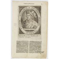
Eduardus Princeps Cambriae, Terror Gallorum.
The engraving depicts a half length oval portrait of Edward Prince of Wales.Nicolaes de Clerck (de Klerc) was active as engraver and publisher in Delft from 1599-1621.Inc...
Date: Amsterdam, Cloppenburch, 1621
Selling price: ????
Please login to see price!
Sold in 2018
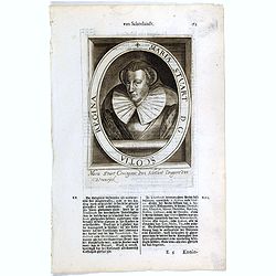
Maria Stuart. D. G. Scotia Regina.
The engraving depicts a half length oval portrait of Mary Stuart.Nicolaes de Clerck (de Klerc) was active as engraver and publisher in Delft from 1599-1621.Included in th...
Date: Amsterdam, Cloppenburch, 1621
Selling price: ????
Please login to see price!
Sold
Iacobus V. Dei Gratia, Rex Scotorum.
The engraving depicts a half length oval portrait of James V of Scotland.Nicolaes de Clerck (de Klerc) was active as engraver and publisher in Delft from 1599-1621.Includ...
Date: Amsterdam, Cloppenburch, 1621
Selling price: ????
Please login to see price!
Sold in 2016
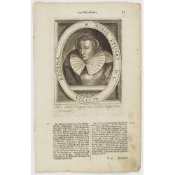
Maria Stuart. D. G. Scotia Regina.
The engraving depicts a half length oval portrait of Mary, Queen of Scots (1542 – 1587), also known as Mary Stuart or Mary I of Scotland, was Queen of Scotland from 14 ...
Date: Amsterdam, Cloppenburch, 1621
Selling price: ????
Please login to see price!
Sold in 2016
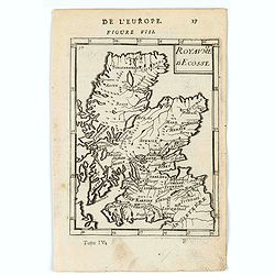
Schotia
Charming small map of Scotland decorated with a strapwork title cartouche. Latin text on verso.
Date: Amsterdam 1628
Selling price: ????
Please login to see price!
Sold
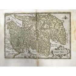
Scotiae regnum.
Detailed map of Northern part of Scotland, made of 2 maps pasted together.Mercator was born in Rupelmonde in Flanders and studied in Louvain under Gemma Frisius, Dutch wr...
Date: Amsterdam 1630
Selling price: ????
Please login to see price!
Sold
Scotia Regnum.
Detailed map of Scotland. This map was to remain the standard map of Scotland, until a new map by Robert Gordon was published in 1654 (Shirley, p. 78).Mercator was born i...
Date: Amsterdam, 1630
Selling price: ????
Please login to see price!
Sold in 2015
Scotiae regnum.
Detailed two-sheet map of Scotland.Mercator was born in Rupelmonde in Flanders and studied in Louvain under Gemma Frisius, Dutch writer, astronomer and mathematician. The...
Date: Amsterdam, 1630
Selling price: ????
Please login to see price!
Sold in 2016
Scotiae regnum.
Detailed map of Scotland, made of 2 maps pasted together.Mercator was born in Rupelmonde in Flanders and studied in Louvain under Gemma Frisius, Dutch writer, astronomer ...
Date: Amsterdam, 1630
Selling price: ????
Please login to see price!
Sold in 2010
Scotia Regnum.
A lovely detailed map of Scotland. This map was to remain the standard map of Scotland, apart from some minor improvements by Speed, until a new map by Robert Gordon in 1...
Date: Amsterdam, 1630
Selling price: ????
Please login to see price!
Sold in 2018
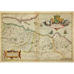
A New Description of the Shyres Lothian and Linlitquo. Be T.Pont.
A Scottish clergyman, Timothy Pont's survey of Scotland of 1595-1608 made that country the best mapped in the world. However it was not until Blaeu issued the maps as Vol...
Date: Amsterdam, 1633
Selling price: ????
Please login to see price!
Sold in 2011
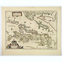
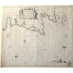
De Custen van Engeland en Schotlandt tusschen Tinbij en de Eijlanden van Orcanesse.
Very rare of the coasts of Scotland, with Aberdeen, from The New Fierie Sea-Colomne, published in 1640 by Jacob Aertz. Colom. .
Date: Amsterdam, 1640
Selling price: ????
Please login to see price!
Sold in 2010
No title: Scotland.
Detailed map of Scotland with Glasgow (Glasquo) in center.
Date: Amsterdam, 1642
Selling price: ????
Please login to see price!
Sold in 2018
Scotia Regnum.
A attractive example of this fine map of Scotland. In upper right hand corner inset of Orkney Islands.
Date: Amsterdam 1639-1644
Selling price: ????
Please login to see price!
Sold
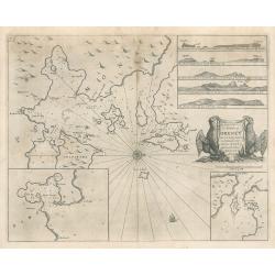
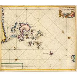
Orcadum et Schetlandiae insularum..
Two maps on one sheet. Showing the Orkney- and Shetland Islands.
Date: Amsterdam 1639-1644
Selling price: ????
Please login to see price!
Sold
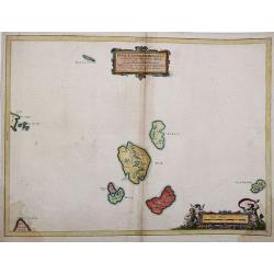
Insulae Quaedam Minores ex Aebudis quae Mulam et Skiam. . .
Insulae Quaedam Minores ex Aebudis quae Mulam et Skiam…c1634 by Joan Blaeu after Timothy Pont. Sub-titled "Some of the Smaller Western Yles, lying between the Yles...
Date: Amsterdam, 1645
Selling price: ????
Please login to see price!
Sold in 2012
Scotia Regnum.
A attractive example of this fine map of Scotland with two coats of arms and an in-set map of the Orkney Islands.
Date: Amsterdam, ca.1645
Selling price: ????
Please login to see price!
Sold in 2017
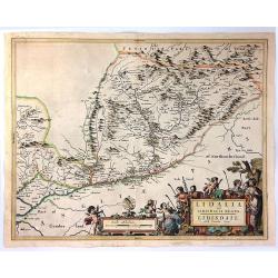
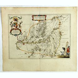
Comitatus Caernarvoniensis. . .
A fine Blaeu map of Caernarvonshire and Anglesey with present-day Gwynedd, including Bangor, Colwyn, Pwllheli, etc. Very detailed with many place names, hills, rivers, la...
Date: Amsterdam, ca 1650
Selling price: ????
Please login to see price!
Sold in 2020
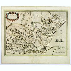
Lidelia Vel Lidisdalia Regio, Lidisdail.
A map of Liddesdale, a historic district of Scotland, bordering Teviotdale to the east, Annandale to the west, and Tweeddale to the north, with the English county of Cumb...
Date: Amsterdam, 1654
Selling price: ????
Please login to see price!
Sold in 2016
Southerlandia.
A map from the first comprehensive atlas of Scotland, published by Blaeu in 1654, after an earlier work of the region by Gordon. 'Southerlandia' is a highland region of n...
Date: Amsterdam, 1654
Selling price: ????
Please login to see price!
Sold in 2018
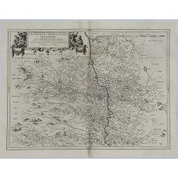
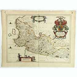
Glottiana Praefectura Inferior cum Baronia Glascuensi.
A fine map of the Glasgow region of Scotland. It extends from Glasgow to Lanark with Hamilton at its centre, and Kyle to Lothian. The map was drawn by Timothy Pont and su...
Date: Amsterdam, 1654
Selling price: ????
Please login to see price!
Sold in 2018
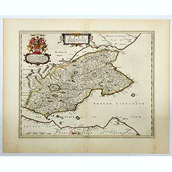
Fifae Vicecomitatus. The Sherifdome of Fyfe.
A decorative Scottish county map by Blaeu. It shows the whole Fife peninsula with Edinburgh at bottom of the map. Published in his Atlas Novus Vol. 5 in 1654, The map is ...
Date: Amsterdam, 1654
Selling price: ????
Please login to see price!
Sold in 2023
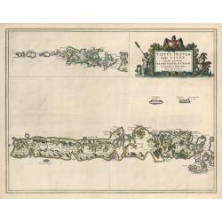
Vistus Insula, vulgo VII ST, cum aliis minoribus
This scarce map of Barra and North and South Uist in the Outer Hebrides of Scotland by Joan Blaeu was based on the surveys done by Timothy Pont some half-century earlier....
Date: Amsterdam, 1654
Selling price: ????
Please login to see price!
Sold in 2023
The Kingdome of Scotland.
Attractive rare "carte Ă figures"- map of Scotland embellished with the portraits of A Scotch man, A Highland Man, A Scotch Woman, and a Highland Woman.English...
Date: London, 1662
Selling price: ????
Please login to see price!
Sold in 2012
Lothian and Linlitquo.
This is a very detailed and striking map of the areas of Lothian and Linlithgow in Scotland. It is rare from Joan Blaeu's Atlas Major, with three added ships.The map cent...
Date: Amsterdam, 1662
Selling price: ????
Please login to see price!
Sold in 2018
Nithia Vicecomitatus, The Shirifdome of Nidis-dail / auctore Timotheo Pont.
This is a detailed and striking map of the areas of Nidis-dail in Scotland. It is rare from Joan Blaeu's Atlas Major.Prepared by Timothy Pont and Robert Gordon. The map i...
Date: Amsterdam, 1662
Selling price: ????
Please login to see price!
Sold in 2019
![Carricta meridionalis, [vulgo], The South part of Carrick / auct. Timoth. Pont.](/uploads/cache/42489-250x250.jpg)
Carricta meridionalis, [vulgo], The South part of Carrick / auct. Timoth. Pont.
This detailed and striking map of the southern part of Carrick in Scotland is rare from Joan Blaeu's Atlas Major.Prepared by Timothy Pont and Robert Gordon. The map is en...
Date: Amsterdam, 1662
Selling price: ????
Please login to see price!
Sold in 2020
Cuninghamia / ex schedis Timotheo Pont , Ioannis Blaeu excudebat. Cunningham.
A very detailed map and a striking map of Cunningham in Scotland. Rare from Joan Blaeu's Atlas Major.Prepared by Timothy Pont and Robert Gordon. The map is enhanced by se...
Date: Amsterdam, 1662
Selling price: ????
Please login to see price!
Sold in 2019
Lorn Wt the Yles and provinces bordering there-upon.
This is the lovely Blaeu map of Lorn, published in Amsterdam during the second half of the seventeenth century. The map is oriented to the west. Lorn is an area situated ...
Date: Amsterdam, ca 1664
Selling price: ????
Please login to see price!
Sold in 2019
Carricta Meridionalis, The South part of Carrick.
Map of the south part of Carrick, a district in Scotland, outlined in colorful ribbons. Smaller town are shown within the region, many noticeably long the rivers that int...
Date: Amsterdam, c. 1667
Selling price: ????
Please login to see price!
Sold in 2010
A Mapp of ye County of Mounmouthshire with Hundreds.
A very attractive map of Monmouthshire in Wales, which appeared in Richard Blome's 'Britannia'. Detailed with place names, rivers, and hills. Decorated with the title car...
Date: London, 1673
Selling price: ????
Please login to see price!
Sold in 2020
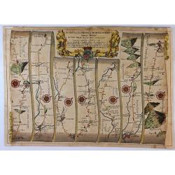
The Road from London To Montgomery North Wales. . .
A sheet showing part of the route from London to Montgomery in Worcestershire that includes the towns of Evesham, Worcester, Ludlow and Montgomery. Taken from John Ogilby...
Date: London, 1675
Selling price: ????
Please login to see price!
Sold in 2017
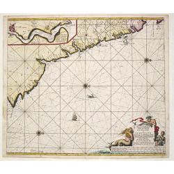
![[Lot of 2 charts and 40 pages of text with prints of coastal profiles] Nieuwe Pascaert vande Oost Cust van Schotlandt Beginnende van Barwyck tot aen de Orcades Ylanden. [Together with a sea-chart of England's east coast.]](/uploads/cache/18507-(1)-250x250.jpg)
[Lot of 2 charts and 40 pages of text with prints of coastal profiles] Nieuwe Pascaert vande Oost Cust van Schotlandt Beginnende van Barwyck tot aen de Orcades Ylanden. [Together with a sea-chart of England's east coast.]
A fine seachart of the east coast of Scotland with the Orkney Islands. Embellished with two cartouches.From the ' Nouveau et Grand Illuminant Flambeau de la Mer'.The succ...
Date: Amsterdam, c. 1680
Selling price: ????
Please login to see price!
Sold in 2022
![[Lot of 11 maps / prints of the United Kingdom.]](/uploads/cache/100251-(1)-250x250.jpg)
[Lot of 11 maps / prints of the United Kingdom.]
An attractive map of the United Kingdom, with an inset map depicting the Orcades and Shetland islands. Embellished with two cartouches.[lot of 11 maps / prints]
Date: Amsterdam, c. 1680
Selling price: ????
Please login to see price!
Sold in 2022
Paskaart vande Noord Cust van Schotland als mede de Eylanden van Hitlandt en Fero.
Sea chart of Northern Scotland with the Orkney islands, the Shetland Islands and the Faroe Islands, oriented to the South.From: De Nieuwe Groote Lichtende Zee-Fakkel, .....
Date: Amsterdam, 1682
Selling price: ????
Please login to see price!
Sold in 2014
Nieuwe Pascaert van de oost cust van Schotlandt beginnende van Barwyck tot aen de Orcades Ylanden.
Sea chart of the east coast of Scotland, oriented to the West. With engraved plate number 18.
Date: Amsterdam, 1682
Selling price: ????
Please login to see price!
Sold in 2013
Ecosse.
A charming miniature map of Scotland. Title in curtain draped at top. French text on verso.From the original 1683 text edition of "Description d'Univers. . ." b...
Date: Paris, 1683
Selling price: ????
Please login to see price!
Sold in 2020
Royaume d'Ecosse.
A charming miniature map of Scotland. Title in curtain draped at top. French text on verso.From the original 1683 text edition of "Description d'Univers. . ." b...
Date: Paris, 1683
Selling price: ????
Please login to see price!
Sold in 2020
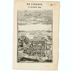
Edimbourg.
A charming bird's-ey plan of Edinburgh. Title in curtain draped at top. French text on verso.From the original 1683 text edition of "Description d'Univers. . ."...
Date: Paris, 1683
Selling price: ????
Please login to see price!
Sold in 2020
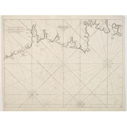
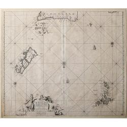
The Chiefe Harbours in the Islands of Orkney
This interesting sea chart is the work of Captain Greenville Collins, hydrographer to the King Charles II of England in the 17th century, and one of the best known Englis...
Date: London, 1688
Selling price: ????
Please login to see price!
Sold in 2023
Cambriae typus, Auctore Humfredo Lhuydo.
From the Hornius edition of the Ancient Atlas by Janssonius. No text on verso.Engraved by Petrus Kaerius.
Date: Amsterdam, ca 1690
Selling price: ????
Please login to see price!
Sold in 2013
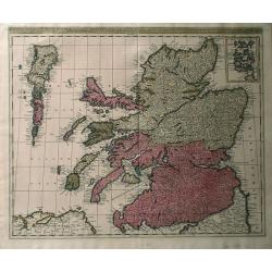
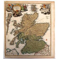
Exactissima regni Scotiae tabula. . .
A superb map of Scotland by Visscher, published in Amsterdam at the end of the seventeenth century. All the Scottish counties are colored in outline. There is a tremendou...
Date: Amsterdam, 1690
Selling price: ????
Please login to see price!
Sold in 2019
![Scotia parte settentrionale. . . [together with] Scotia parte meridionale . . .](/uploads/cache/45627-250x250.jpg)
Scotia parte settentrionale. . . [together with] Scotia parte meridionale . . .
A large two-sheet map of Scotland. The Northern map features a list of provinces and their capitals at the upper left and a title cartouche on the right side. The Souther...
Date: Venice, 1698
Selling price: ????
Please login to see price!
Sold in 2020
Regnun Scotiae, feu pars Septent: Magnae Brittanniae, divifa in Scotiam Septent: et Auftralem, porro autem in Comit: Rossiam Maraviam, Praefect: Lavdoniam, Renefroviam et Arandum, una cum Infulis Ebuda Occident: et Orient: Mula, Jura et Ila.
A wonderfully detailed map of Scotland and the islands off its coast by Gerard and Leonard Valk. This map includes major cities, rivers and towns, and at the top right in...
Date: Amsterdam, 1700
Selling price: ????
Please login to see price!
Sold in 2010
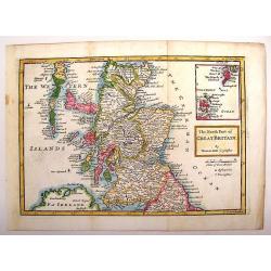
The North Part of Great Britain.
Interesting map of northern Great Britain (Scotland). It has an inlay of the Shetland and Orkney Islands. Herman Moll (1654 – 1732), was a cartographer, engraver, and ...
Date: London, 1708
Selling price: ????
Please login to see price!
Sold in 2013
Novissima Regni Scotiae Septentrionalis et Meridionalis. . .
A rare and decorative double-page map of Scotland and its islands. Includes a wealth of place names, and extends until the Picts Wall near Carlisle. With bright original ...
Date: Amsterdam, 1708
Selling price: ????
Please login to see price!
Sold in 2018
Magnae Britannia Pars Septentrionalis qua Regnum Scotiae.
Large,detailed and decorative map of Scotland with two superb cartouches. They are surrounded by mythical and allegorical figures, five putti, and Royal & Scottish ar...
Date: Nuremberg, 1710
Selling price: ????
Please login to see price!
Sold in 2014
Nieuwe Paskaart van de Orcades Eylanden
The successful van Keulen firm published charts, pilot guides and sea-atlases for over 2 centuries. Founded by Johannes van Keulen, his son Gerard led the firm to its zen...
Date: Amsterdam, 1715
Selling price: ????
Please login to see price!
Sold in 2010
Nieuwe Paskaert Vande oost Cust van Engeland en Schotland. Beginnende van 't Flamburger Hooft tot aan de Rivier van Eedenborg. Inset: The River Tyne.
The successful van Keulen firm published charts, pilot guides and sea-atlases for over 2 centuries. Founded by Johannes van Keulen, his son Gerard led the firm to its zen...
Date: Amsterdam, 1715
Selling price: ????
Please login to see price!
Sold in 2008
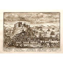
Edimbourg Ville Capitale du Royaume d'Ecosse.
"A very RARE panoramic view of the city of Edinburgh, including a numbered legend in the lower part.Published by the brothers Chéreau, active in Paris at ...
Date: Paris c.1720
Selling price: ????
Please login to see price!
Sold
Exactissima Regni Scotiae Tabula tam in septentrionalem et meriodionalem quam in minores earundem provincias insulesq, et undique praetensas accurate . , ,
A magnificent and detailed map of Scotland, with all the counties, cities and towns, castles and churches, lochs, rivers and streams shown. This example with the imprint ...
Date: Amsterdam, 1690 -1720
Selling price: ????
Please login to see price!
Sold in 2018
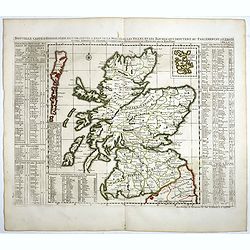
Nouvelle carte d'Ecosse . . .
Decorative map of Scotland with index tables giving details of the nobility, geographical divisions and notable settlements down both sides.Henri Abraham Chatelain (1684 ...
Date: Amsterdam, 1720
Selling price: ????
Please login to see price!
Sold in 2020
Exactissima Regni Scotiae Tabula. . .
This lovely copper engraved map includes all of Scotland, the Orkney Islands and the New Hebrides, here called the Westerne Iles of Scotland. The map is filled with minut...
Date: Amsterdam, 1720
Selling price: ????
Please login to see price!
Sold in 2021
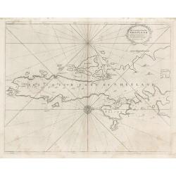
The South Part of Shetland
This decorative copperplate nautical chart was part of the work commissioned by Charles II of England when Samuel Pepys was Secretary to the Admiralty. The work was to ch...
Date: London, 1723
Selling price: ????
Please login to see price!
Sold in 2023
