Browse Listings in Europe > British Isles
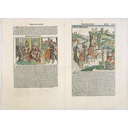
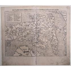
Anglie Provincia (Tercia estas mundi Foliu XLVI ) / Salomon's genealogy tree (XLVI) / Genealogy tree & Abner & Joab (XLVII) / Judgment of Solomon (XLVII).
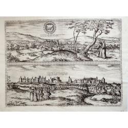
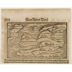
Woodcuts depicting an imaginary England countryside, showing a fortified city above a fast-flowing river. According to Rodney Shirley "[the two woodcuts] are masterf...
Date: Nuremberg, 12 July 1493
Selling price: ????
Please login to see price!
Sold in 2020
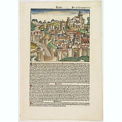
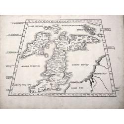
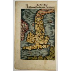
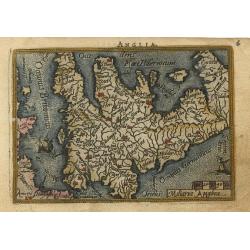
Anglia / Hispania. Fo CCLXXXVIIII.
Text page in Latin on recto a hill-side city in England with a series of gates leading up to a citadel. It is one of two woodcuts used for England in the work. On the ver...
Date: Nuremberg, 12 July 1493
Selling price: ????
Please login to see price!
Sold in 2017
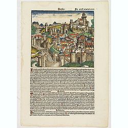
Anglia Fo CCLXXXVIIII (Town in England)
Text page in latin on recto a hill-side city in England with a series of gates leading up to a citadel. It is one of two woodcuts used for England in the work. On the rer...
Date: Nuremberg, 12 July 1493
Selling price: ????
Please login to see price!
Sold in 2017
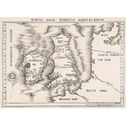
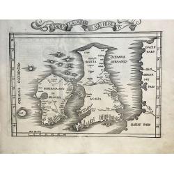
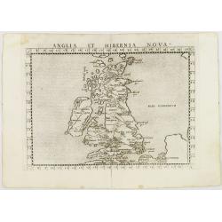
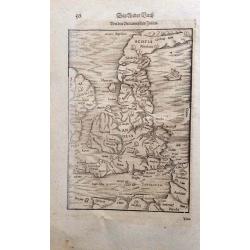
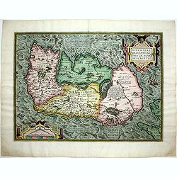
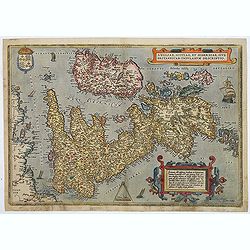
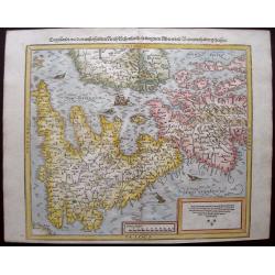
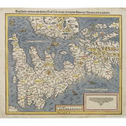
Tabula nova Hibernie Anglie et Scotie.
Martin Waldseemuller's issue of "Geographia," published in 1513 and 1520, was one of the most important atlases of the first half of the sixteenth century as th...
Date: Strasbourg, 1513-1520
Selling price: ????
Please login to see price!
Sold in 2009
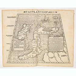
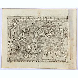
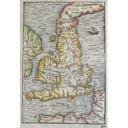
TAB I EURO PRINCIPIUM EUROPAE....TABULA I EUROPAE
Martin Waldseemuller's edition of the classical cartography of Claudius Ptolemy that had first appeared in 1513.The British Isles, set in a trapezoid frame this woodblock...
Date: Stassburg, 1522
Selling price: ????
Please login to see price!
Sold in 2012
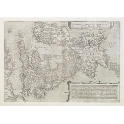
Tabula Moderna Hiber.
One of the Earliest obtainable Modern Maps of the British Isles. A nice example of the 1525 edition of Lorenz Fries's double-page woodblock modern map of the British Isl...
Date: Strasbourg, 1525
Selling price: ????
Please login to see price!
Sold in 2021
![[Map of the British Isles]](/uploads/cache/40500-250x250.jpg)
[Map of the British Isles]
First edition Inghilterra.Rare: A very early woodblock map of the British Isles by the Italian cartographer Benedetto Bordone, an 16th century illuminator and wood engrav...
Date: Venice, 1528
Selling price: ????
Please login to see price!
Sold in 2017
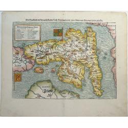
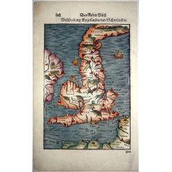
Das Kunigreich Engelland, mit dem anstossenden Reich Schottland, so vor zeiten Albion und Britannia, haben geheissen.
An early, unusual woodcut map of the British Isles, which is oriented to the East. Sebastian Munster's map was the first separately printed map of England and a landmark ...
Date: Basel, ca 1540
Selling price: ????
Please login to see price!
Sold in 2019
![[Great Britain, Ireland]](/uploads/cache/33865-250x250.jpg)
[Great Britain, Ireland]
Wood block printed map and one of earliest printed representation of the Great Britain and Ireland prepared Martin Waldseemüller. Based on the slightly larger map from 1...
Date: Vienna, Trechsel, G., 1525 -1541
Selling price: ????
Please login to see price!
Sold in 2013
![[Map of the England]](/uploads/cache/31504-250x250.jpg)
[Map of the England]
Page with an early representation of the British Isles. This text page with a fine wood block printed map is from the rare work "C. Iulii Solini Polyhistor, Rerum To...
Date: Basle, Michael Isengrin, 1544
Selling price: ????
Please login to see price!
Sold in 2011
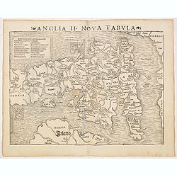
Anglia II Nova Tabula (British Isles)
The first edition of Munster's first printed separate map of England and Wales, with Scotland as far north as Edinburgh, the east coast of Ireland and north coast of Fran...
Date: Basel, Heinrich Petri, 1545
Selling price: ????
Please login to see price!
Sold in 2014
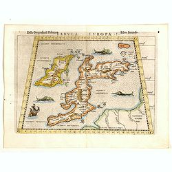
Tabula Europae I (Great Brittain)
The first edition of Munster's Ptolemaic map of Great Britain appeared in his "Geographia Universalis", first published in 1540. This was a new and important ed...
Date: Basel, Heinrich Petri, 1545
Selling price: ????
Please login to see price!
Sold in 2014
Tabula Europae I (Great Britain).
Nice example of the rare third state of Ruscelli's map of the British Isles, based Claudius Ptolemy.The map first appeared in the 1561 edition of Ruscelli's edition of Pt...
Date: Basel, Heinrich Petri, 1545
Selling price: ????
Please login to see price!
Sold in 2017
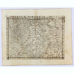
Anglia e Hibernia Nova
Gastaldi's modern map of the British Isles. It is one of the earliest obtainable modern maps of the British Isles.From Giacomo Gastaldi's Atlas of 1548, which has been ca...
Date: Venice, 1548
Selling price: ????
Please login to see price!
Sold in 2021
Tabula Europae I. (British Isles)
Gastaldi's map of the British Isles is based on Ptolemy. It is one of the earliest obtainable maps of the region.From Giacomo Gastaldi's Atlas of 1548, which has been ca...
Date: Venice, 1548
Selling price: ????
Please login to see price!
Sold in 2021
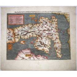
Beschreibung Engellandts und Schottlandts.
A full-page woodcut map of England, Scotland, Wales, and part of Ireland, published in Basel, circa 1550. This charming woodblock map of Britain is the base for the Merca...
Date: Basel, ca 1550
Selling price: ????
Please login to see price!
Sold in 2021
Das Engelland, mit dem anstossenden Reich Schottland. . . Britannia. . .
An antique map of England and Wales, with parts of Scottland and Ireland. Full title : Engellandt/ mit dem anstossenden Reich Schottlandt/ so vor zeiten Albion und Britan...
Date: Basel ca 1550
Selling price: ????
Please login to see price!
Sold in 2020
![[Lot of 8 leaves of Great Britain, Edinburgh]](/uploads/cache/48262-250x250.jpg)
[Lot of 8 leaves of Great Britain, Edinburgh]
Eight text leaves with woodblock illustrations relating to Great Britain and Edinburgh, featuring small maps and views, from the 1552 Latin text edition of Münster's Cos...
Date: Basel, 1552
Selling price: ????
Please login to see price!
Sold in 2026
Anglia et Hibernia Nova. . .
Uncommon first edition of one of the earliest maps of Great Britain.Girolamo Ruscelli's edition of Ptolemy's Geographia included newly engraved copperplates by Giulio and...
Date: Venice, 1561
Selling price: ????
Please login to see price!
Sold in 2008
Britania Insula quae dup Regna continet Angliam et Scotiam cum Hibernia adiacente. Ferando Berteli exc. 1561. Venise: 1562
One of the earliest printed maps of England. The essential roots of mid-16th century mapping of the British Isles go back to the English catholic priest George Lily (ca 1...
Date: Venice, 1564
Selling price: ????
Please login to see price!
Sold
Britannischen Insula.
An unusual outline of the British Isles, influenced by Ptolemy.
Date: Basle, 1570
Selling price: ????
Please login to see price!
Sold in 2016
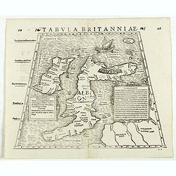
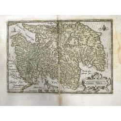
Tabula Britanniae. (British Isles)
Double-page woodcut Ptolemaic-style map by Sebastian Münster, showing the British Isles, published in the edition of Strabo by Henri Petri in 1571."Strabonis rerum ...
Date: Basle, Henri Petri, 1571
Selling price: ????
Please login to see price!
Sold in 2018
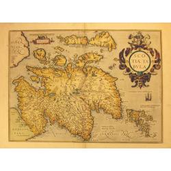
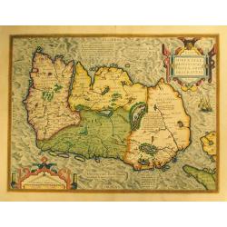
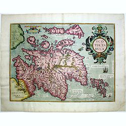
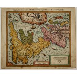
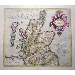
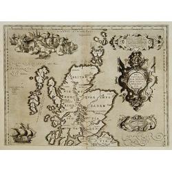
Scotiae Tabula.
Original old colored map of Scotland by A. Ortelius with north to the right of the plate. With one large cartouche, one sailing ship and a sea monster. From the 1573 Dutc...
Date: Antwerp, 1573
Selling price: ????
Please login to see price!
Sold in 2012
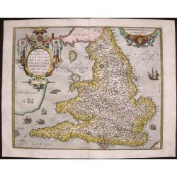
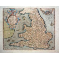
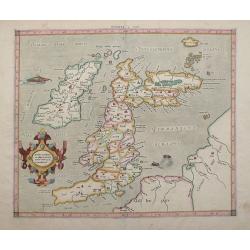
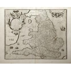
Angliae Regni flo: rentissimi nova descriptio, auctore Humfredo Lhuyd.
Stunning map of England and Wales compiled from Mercator's 1564 wall map of the British Isles and Lhuyd's manuscript map of 1568. The countryside is fully engraved with t...
Date: Antwerp, 1573
Selling price: ????
Please login to see price!
Sold in 2017
Hiberniae Britannicae insulae nova descriptio.
Copied from Mercator's influential wall map of the British Isles of 1564, this is certainly the best map of Ireland of the 16th century.
Date: Antwerp, 1574
Selling price: ????
Please login to see price!
Sold in 2015
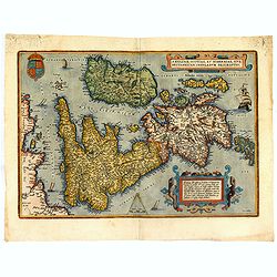
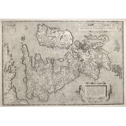
Eryn - Hiberniae, Britannicae Insulae, Nova Descriptio - Irelandt.
A beautiful map of Ireland from Ortelius' "Theatrum Orbis Terrarum." This map is significant as the first separate printed map of Ireland. It’s also one of th...
Date: Antwerp, 1574
Selling price: ????
Please login to see price!
Sold in 2012
![Tabula Europae I [British Isles].](/uploads/cache/42111-250x250.jpg)
Tabula Europae I [British Isles].
An early double page Ptolemaic map of the British Isles from 'La Geografia Di Claudio Tolomeo Alessandrino...' published by G. Ziletti, Venice (using plates from the 1561...
Date: Venice, 1574
Selling price: ????
Please login to see price!
Sold in 2019
Anglia et Hibernia Nova. . .
One of the earliest maps of Great Britain.Girolamo Ruscelli's edition of Ptolemy's Geographia included newly engraved copperplates by Giulio and Livio Sanuti. From the se...
Date: Venice, 1574
Selling price: ????
Please login to see price!
Sold in 2009
Scotiae tabula.
Very fine general map of Scotland with north to right of page. Derived from Mercator's 1564 map of the British Isles in 8 sheets.
Date: Antwerp, 1574
Selling price: ????
Please login to see price!
Sold in 2016
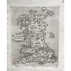
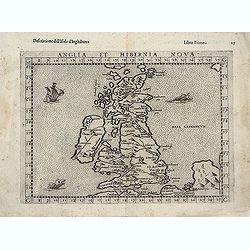
INGILTERRA ET SCOTIA.
One of the earliest modern Maps of England, Wales & Scotland. A very rare early map of England, Wales and Scotland, with topography and main settlements, depicted pic...
Date: Venice, 1570-1575
Selling price: ????
Please login to see price!
Sold in 2022
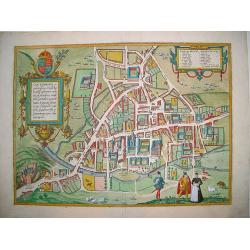
Cantebrigia...
A sought after and highly decorative early bird's-eye plan of the ancient university town of Cambridge. From Braun & Hogenberg's monumental work, CIVITATES ORBIS TERR...
Date: Cologne, ca. 1575
Selling price: ????
Please login to see price!
Sold in 2008
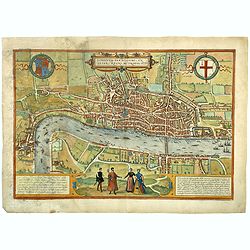
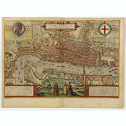
Londinum Feracissimi Angliae Regni Metropolis.
Very desirable and early plan of London - in a second state - shown from the Tower to Westminster, with the City already built-up and a ribbon development westwards along...
Date: Cologne, (1572) 1577
Selling price: ????
Please login to see price!
Sold in 2018
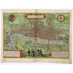
Londinium Feracissmi Angliae Regni Metropolis.
Very desirable and early plan of London - in a second state - shown from the Tower to Westminster, with the City already built-up and a ribbon development westwards along...
Date: Cologne, (1572) 1577
Selling price: ????
Please login to see price!
Sold in 2013
Das Engellandt/ mit dem anstossenden Reich Schottland/ so vorzeiten Albion und Britannia/ haben geheissen.
A woodcut map; on laid paper. This map is from the last German edition of the well-published 'Cosmographia', with Scotland orientated to the West. The map is decorated wi...
Date: Basle, 1578
Selling price: ????
Please login to see price!
Sold in 2016
Beschreibung Engellandts und Schottlandts.
From 'Cosmographia, das ist: Beschreibung der Gantzen Welt,...'; published in Basle, c1578, German edition.wood engraving set into text; overall size 33 x 20 cm. On verso...
Date: Basle, c. 1578
Selling price: ????
Please login to see price!
Sold in 2015
Beschreibung Engellands und Schottlandts
A very early and attractively coloured map of the UK, Engeland, Schotland, Ireland, and Wales, on a full leaf. A wonderful woodcut with picturesquely cut cities, seas and...
Date: Basel, 1578
Selling price: ????
Please login to see price!
Sold in 2021
Angliae Scotiae et Hibernie nova descriptio.
FIRST EDITION of this fine example of De Jode's rare map of the British Isles, oriented with West at the top. The map was based on Mercator's wall map from 1554. From the...
Date: Antwerp 1578
Selling price: ????
Please login to see price!
Sold
Engellandt/ mit dem anstossenden Reich Schottlandt/ so vorzeiten Albion und Britannia haben geheissen.
From 'Cosmographia, das ist: Beschreibung der Gantzen Welt,...'; German edition. wood engravings set into text; overall size 33 x 20 cm. on verso: engraved title. Münst...
Date: Basle, c. 1578
Selling price: ????
Please login to see price!
Sold in 2015
Anglia et Hibernia Nova. . .
One of the earliest maps of Great Britain.Girolamo Ruscelli's edition of Ptolemy's Geographia included newly engraved copperplates by Giulio and Livio Sanuti. From the se...
Date: Venice, 1579
Selling price: ????
Please login to see price!
Sold in 2013
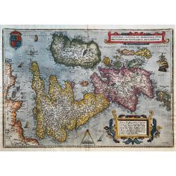
Anglia, Scotiae et Hiberniae, Sive Brittannicar: Insularum Descriptio
A classic and famous map of the British Isles with North to the right.Probably the earliest map of the British Isles that are still available. Despite the fact, that the ...
Date: Antwerp, 1579
Selling price: ????
Please login to see price!
Sold in 2019
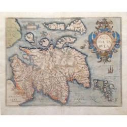
Scotiae Tabula.
From the Theatrum Orbis Terrarum, 1579. A fine map of Scotland with north to the right of the page. Ortelius derived this map from Mercator's 1564 map of the British Isle...
Date: Antwerp, 1579
Selling price: ????
Please login to see price!
Sold in 2018
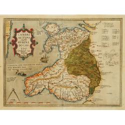
Cambriae Typus..
Ancient map of Wales, prepared by Humphrey Lhuyd. With fine cartouche, ship and a sea monster.
Date: Antwerp 1579
Selling price: ????
Please login to see price!
Sold
Londinum Feracissimi Angliae Regni Metropolis.
A very desirable and early plan of London, shown from the Tower to Westminster, with the City already built-up and a ribbon development westwards along the Strand. On the...
Date: Cologne, 1580
Selling price: ????
Please login to see price!
Sold in 2021
![[Edinburgh]](/uploads/cache/26202-250x250.jpg)
[Edinburgh]
Early panoramic view of Edinburgh. From his Cosmographia, that great compendium of Renaissance knowledge. An exciting print.Sebastian Münster was born in Nierder-Ingelhe...
Date: Basle, 1550-1580
Selling price: ????
Please login to see price!
Sold in 2009
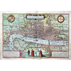
Londinum Feracissimi Angliae Regni Metropolis.
Important, early bird's-eye view of London, which appeared in the first Volume of Civitates Orbis Terrarum by Braun & Hogenberg.The view is based on a previous 15-she...
Date: Cologne, ca 1580
Selling price: ????
Please login to see price!
Sold in 2019
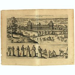
Palatium Regium in Angliæ Regno Appelatum Nonciutz. . .
This engraving is a view of Nonsuch Palace, with carriages and deer hunting, a panel of female costume figures below. Latin text verso, dated in the plate 1582. The scene...
Date: Cologne, 1580
Selling price: ????
Please login to see price!
Sold in 2019
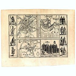
Yorke/ Shrowesbury/ Lancester/ Richmont.
Four views bring city plans of York, Shrewsbury and Lancashire and a view of the castle of Richmond. On each side of the four views are four figures in historical dress: ...
Date: Cologne, 1580
Selling price: ????
Please login to see price!
Sold in 2016
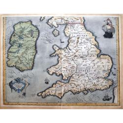
Angliae Regni flo: rentissimi nova descriptio, auctore Humfredo Lhuyd.
From the Theatrum Orbis Terrarum - French Text - this is Humphrey Lloyd's depiction of England and Wales published in the first Additamentum to the Ortelius atlas. The m...
Date: Antwerp, 1581
Selling price: ????
Please login to see price!
Sold in 2013
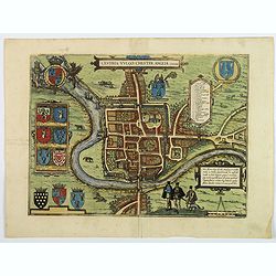
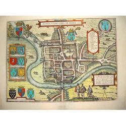
Cestria vulgo Chester, Angliae Civitas.
A stunning town plan of the northern city of Chester, with heraldic shields, Royal and civic coats of arms, explanation table, dividers and Elizabethan figures in the for...
Date: Cologne, ca 1582
Selling price: ????
Please login to see price!
Sold in 2018
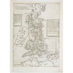
Angliae, scotiae, et Hiberniae, sive Britannicar insularum.
A state 3 of this classic, handsome and decorative map of ancient British Isles with north orientated to the east. Latin text on verso.Based on Mercator's 1564 map of the...
Date: Antwerp, after 1584
Selling price: ????
Please login to see price!
Sold in 2018
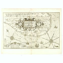
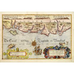
De Zee Custen tuschen Dovere eñ Orfordts nesse, daer de Teemse de Vermaerde Riviere vã Lõnen gelegens is, met alle sanden ondiepte, naer haren wesen eñ ghedaente / Orae maritimae inter Doverium et Ortfortnissam &tc.
Lucas Janszoon Waghenaer (1533/4-1606) published in 1583 his famous pilot-guide ' Spieghel der Zeevaerdt', the first printed pilot-guide with charts, in 1592 he published...
Date: Leiden, 1585
Selling price: ????
Please login to see price!
Sold in 2008
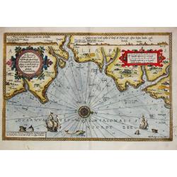
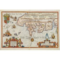
Zee Caerte vande Noordt custe van Engelandt, alsoe tzelffde landt aldaer. . .
A detailed description of the northern coast of England. Decorated by a title cartouche and scale cartouche, one compass rose, several vessels. A very early edition rare ...
Date: Leiden, Plantijn, 1585
Selling price: ????
Please login to see price!
Sold in 2016
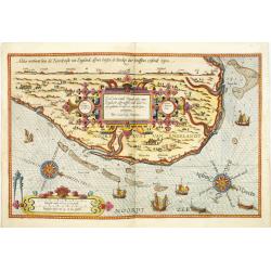
Befchrijvinghe der Zee, custen van Engelandt, tusschen Pleijmouth en Porthlandt. . .
A detailed chart of the sea coast of England, from Plymouth region along the English Channel to Portland decorated by a very colorful title cartouche and scale cartouche,...
Date: Leiden, Plantijn, 1585
Selling price: ????
Please login to see price!
Sold in 2009
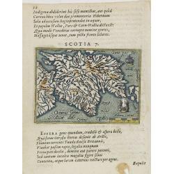
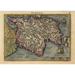
Scotia 7.
A page of printed text in Latin with a fine general map of Scotland. Prepared by Hugo Favolius (1523-1585), who was a Dutch poet, doctor and traveler, born in Middelburg....
Date: Antwerp, Plantin, 1585
Selling price: ????
Please login to see price!
Sold in 2009
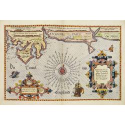
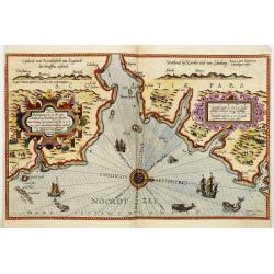
Befchrijvinghe der Zeecusten van Engelandt tusschen Wicht ende Doveren. . .
A detailed chart of the English channel coastland, from the island of Wight to Dover. Decorated by a very colorful title cartouche and scale cartouche, one compass rose, ...
Date: Leiden, Plantijn, 1585
Selling price: ????
Please login to see price!
Sold in 2008
Zee caerte van Engelants Eijndt, Alsoe hem tselfde Landt verthoont beginnende van Sorlinges tot Pleijmondt . . .
A detailed chart of the sea coast of England, from the Sorlinges islands to the Plymouth region along the English Channel decorated by a very colorful title cartouche and...
Date: Leiden, Plantijn, 1585
Selling price: ????
Please login to see price!
Sold in 2009
Zee Caerte vande Noordt custe van Engelandt, alsoe tzelffde landt aldaer. . .
A detailed chart of the northern coast of England. Decorated by a colorful title cartouche and scale cartouche, one compass rose, several vessels. A very early edition ra...
Date: Leiden, Plantijn, 1585
Selling price: ????
Please login to see price!
Sold in 2008
Beschrijvinge van een deel vann Schottlandt van Bambourg tot Aberdein. . .
A detailed chart of the coast of Scotland with Aberdeen. Decorated by a colorful title cartouche and scale cartouche, one compass rose, several vessels and sea monsters. ...
Date: Leiden, Plantijn, 1585
Selling price: ????
Please login to see price!
Sold in 2008
Scotia Regnum.
Printed in Duisberg 1587.
Date: Duisberg, 1587
Selling price: ????
Please login to see price!
Sold in 2014
Angliae, scotiae, et Hiberniae, sive Britannicar : insularum descriptio.
A classic, handsome and decorative map of ancient British Isles with north orientated to the east. Based on Mercator's 1564 map of the British isles and improved by Saxto...
Date: Antwerp, 1587
Selling price: ????
Please login to see price!
Sold in 2017
Angliae, scotiae, et Hiberniae, sive Britannicar insularum.
A classic, handsome and decorative map of ancient British Isles with north orientated to the east. Based on Mercator's 1564 map of the British isles and improved by Saxto...
Date: Antwerp, 1587
Selling price: ????
Please login to see price!
Sold in 2014
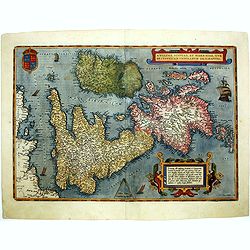
Eryn - Hiberniae, Britannicae Insulae, Nova Descriptio - Irelandt
A beautiful map of Ireland from Ortelius' "Theatrum Orbis Terrarum" or Atlas of the whole world. This is one of the earliest maps of Ireland to present it with ...
Date: Antwerp, 1587
Selling price: ????
Please login to see price!
Sold in 2011
Oxonium nobile Anglie oppidum...; Vindesorium celeberrimum Anglie castrum... 1588
Decorative pair view of Oxford and view of Windsor Castle, from Braun & Hogenberg's "Civitatus Orbis Theatrum", the most famous atlas of city views publishe...
Date: Cologne, 1588
Selling price: ????
Please login to see price!
Sold in 2012
Scotia
Miniature map covering the northern part of England and Scotland. French text on verso. This map is oriented with north to the right. The map is beautifully engraved with...
Date: Antwerp, 1588
Selling price: ????
Please login to see price!
Sold
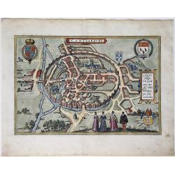
Cestria Vulgo Chester, Angliae Civitas
This desirable, highly decorative depiction presents the city of Chester on the banks of the River Dea. Based on the survey of William Smith, the bird's-eye plan shows th...
Date: Cologne, ca. 1588
Selling price: ????
Please login to see price!
Sold in 2008
Engellandt / mit dem anstossenden Reich Schottlandt / so vor zeiten Albion und Britannia haben geheissen.
Early map of England and the British Isles. The map is oriented with west at the top and provides a fine early depiction of the British Isles, based upon Ortelius' map of...
Date: Basle, S.H. Petrie, 1588
Selling price: ????
Please login to see price!
Sold in 2014
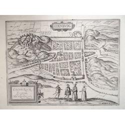
EDENBURG / EDENBURGUM, SCOTIAE METROPOLIS 1588
From an engraving in Ralph Holished’s Chronicles [1574], the Scottish Capital of Edinburgh during the reign of Mary Queen of Scots. Viewed from the South, it includes t...
Date: Cologne, 1588
Selling price: ????
Please login to see price!
Sold in 2012
Anglia
Miniature map covering England and Wales. French text on verso. This map is oriented with north to the right. The map is beautifully engraved with stippled seas and ships...
Date: Antwerp, 1588
Selling price: ????
Please login to see price!
Sold
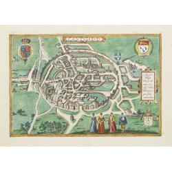
Cantuarbury.
A detailed city map in a 'bird's-eye view' of Canterbury, in original hand coloring, with the cathedral. Title at top centre, with left the crowned coat of arms of Englan...
Date: Cologne, 1588
Selling price: ????
Please login to see price!
Sold in 2020
Cantuarbury.
A spectacular and early view of Canterbury.From the greatest publication in this genre! The Civitates was compiled and written by George Braun, Canon of Cologne Cathedral...
Date: Cologne 1590
Selling price: ????
Please login to see price!
Sold
Engellandt mit dem anstossenden Reich Schottlandt so vor zeiten Albion und Britannia haben geheissen.
A decorative map of Great Britain and eastern part of Ireland. Oriented to the west. Tablet in lower right corner with a brief commentary in German. Two ships and a sea-c...
Date: Basle, 1590
Selling price: ????
Please login to see price!
Sold in 2010
![[British Isles ]](/uploads/cache/32517-250x250.jpg)
[British Isles ]
On recto an early birds-eye view of Great Britain. Cornwall is depicted as an entity on an equal footing as Wales and Scotland.From a Latin text edition of his Geographia...
Date: Basle, 1550-1590
Selling price: ????
Please login to see price!
Sold in 2013
Tab. I. Europae Continens Albion, Britanniam, et Hiberniam.
Mercator’s map of Great Britain, based on Ptolemy’s Geographia. This map is from the 1584 edition of his Tabulae Geographicae. The ancient map of the British Isles ha...
Date: Cologne, Amsterdam, 1590
Selling price: ????
Please login to see price!
Sold in 2012
![[Showing the 1588 defeat of the Spanish Armada in the English Channel]](/uploads/cache/20220907_173700-250x250.jpg)
[Showing the 1588 defeat of the Spanish Armada in the English Channel]
Beautiful engraving by Michael Eytzinger, showing the 1588 defeat of the Spanish Armada in the English Channel. Latin text on verso. Published in Leonis Belgici Descript...
Date: Cologne, ca. 1590
Selling price: ????
Please login to see price!
Sold in 2022
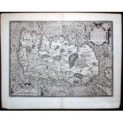
Brittanicarum Insularum Vetus Descriptio.
Southern part of Ortelius important two-sheet map of the British Isles. Includes Ireland, Wales, the Isle of Man, and England. Shows the Hadrian's Wall. Richly decorated ...
Date: Antwerp, c1590
Selling price: ????
Please login to see price!
Sold in 2013
Anglia.
Map of Great Britain.From a German text edition of his Cosmographia , that great compendium of Renaissance knowledge.
Date: Basle 1550-1590
Selling price: ????
Please login to see price!
Sold
Britannicarum Insularum Vetus Descriptio.
Scarce. The upper sheet of a two-sheet map which was issued with the Parergon 1590 and repeated only in the Parergon 1591 and Theatrum 1592 (as present). According to Mar...
Date: Antwerp 1592
Selling price: ????
Please login to see price!
Sold
ANGLIAE, SCOTIAE ET HIBERNIAE, SIVE BRITANNICAR: INSVLARVM DESCRIPTIO.
A beautiful map of the British Isles, north to the right. The map is based on Mercator's earlier map of the British Isles of 1564. Title in strapwork cartouche at top rig...
Date: Antwerp 1592
Selling price: ????
Please login to see price!
Sold in 2016
Scotiae Tabula.
Scarce map of Scotland based on Ortelius. North orientated to the right. Very detailed with many place names. Decorated with sailings ships, a fox holding dividers above ...
Date: Cologne, 1592
Selling price: ????
Please login to see price!
Sold in 2011
Angliae Regni Florentissimi Nova Descriptio, Auctore Humfredo Lhuyd Denbygiense. 1573.
Attractive map of England and Wales compiled from Mercator's 1564 wall map of the British Isles and Lhuyd's manuscript map of 1568. The countryside is fully engraved with...
Date: Antwerp, 1592
Selling price: ????
Please login to see price!
Sold in 2012
