Browse Listings in Europe > British Isles > General
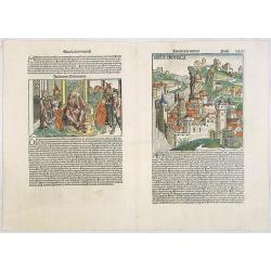
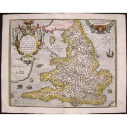
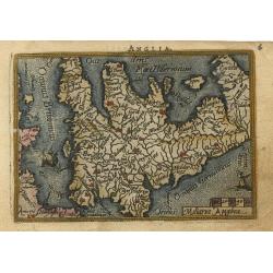
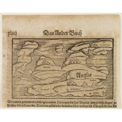
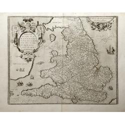
Anglie Provincia (Tercia estas mundi Foliu XLVI ) / Salomon's genealogy tree (XLVI) / Genealogy tree & Abner & Joab (XLVII) / Judgment of Solomon (XLVII).
Woodcuts depicting an imaginary England countryside, showing a fortified city above a fast-flowing river. According to Rodney Shirley "[the two woodcuts] are masterf...
Date: Nuremberg, 12 July 1493
Selling price: ????
Please login to see price!
Sold in 2020
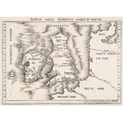
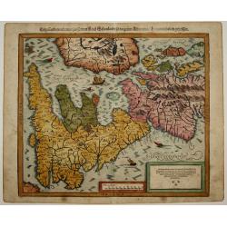
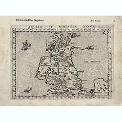
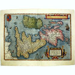
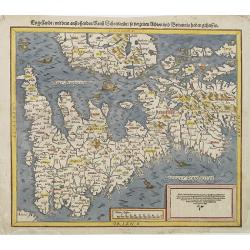
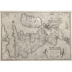
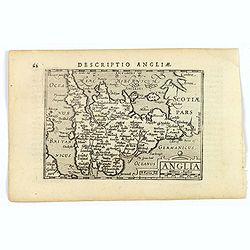
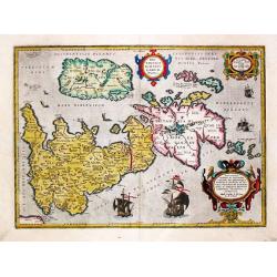
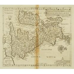
Tabula nova Hibernie Anglie et Scotie.
Martin Waldseemuller's issue of "Geographia," published in 1513 and 1520, was one of the most important atlases of the first half of the sixteenth century as th...
Date: Strasbourg, 1513-1520
Selling price: ????
Please login to see price!
Sold in 2009
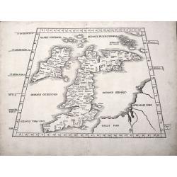
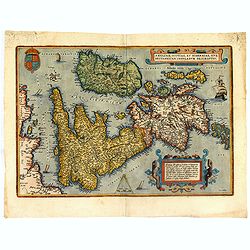
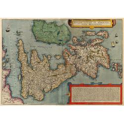
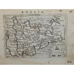
TAB I EURO PRINCIPIUM EUROPAE....TABULA I EUROPAE
Martin Waldseemuller's edition of the classical cartography of Claudius Ptolemy that had first appeared in 1513.The British Isles, set in a trapezoid frame this woodblock...
Date: Stassburg, 1522
Selling price: ????
Please login to see price!
Sold in 2012
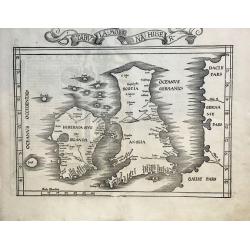
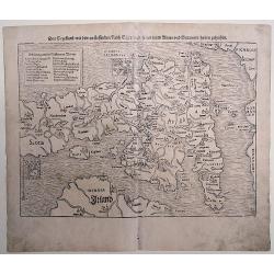
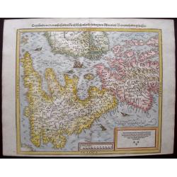
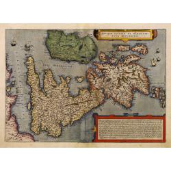
Tabula Moderna Hiber.
One of the Earliest obtainable Modern Maps of the British Isles. A nice example of the 1525 edition of Lorenz Fries's double-page woodblock modern map of the British Isl...
Date: Strasbourg, 1525
Selling price: ????
Please login to see price!
Sold in 2021
![[Map of the British Isles]](/uploads/cache/40500-250x250.jpg)
[Map of the British Isles]
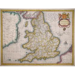
First edition Inghilterra.Rare: A very early woodblock map of the British Isles by the Italian cartographer Benedetto Bordone, an 16th century illuminator and wood engrav...
Date: Venice, 1528
Selling price: ????
Please login to see price!
Sold in 2017
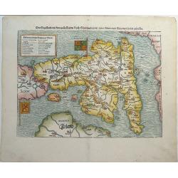
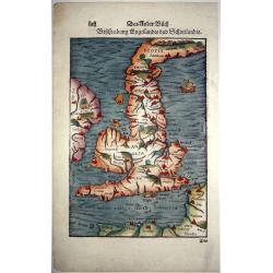
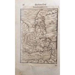
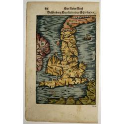
Das Kunigreich Engelland, mit dem anstossenden Reich Schottland, so vor zeiten Albion und Britannia, haben geheissen.
An early, unusual woodcut map of the British Isles, which is oriented to the East. Sebastian Munster's map was the first separately printed map of England and a landmark ...
Date: Basel, ca 1540
Selling price: ????
Please login to see price!
Sold in 2019
![[Great Britain, Ireland]](/uploads/cache/33865-250x250.jpg)
[Great Britain, Ireland]
Wood block printed map and one of earliest printed representation of the Great Britain and Ireland prepared Martin Waldseem├╝ller. Based on the slightly larger map from 1...
Date: Vienna, Trechsel, G., 1525 -1541
Selling price: ????
Please login to see price!
Sold in 2013
![[Map of the England]](/uploads/cache/31504-250x250.jpg)
[Map of the England]
Page with an early representation of the British Isles. This text page with a fine wood block printed map is from the rare work "C. Iulii Solini Polyhistor, Rerum To...
Date: Basle, Michael Isengrin, 1544
Selling price: ????
Please login to see price!
Sold in 2011
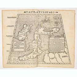
Tabula Europae I (Great Brittain)
The first edition of Munster's Ptolemaic map of Great Britain appeared in his "Geographia Universalis", first published in 1540. This was a new and important ed...
Date: Basel, Heinrich Petri, 1545
Selling price: ????
Please login to see price!
Sold in 2014
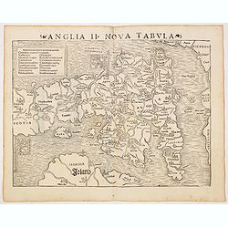
Anglia II Nova Tabula (British Isles)
The first edition of Munster's first printed separate map of England and Wales, with Scotland as far north as Edinburgh, the east coast of Ireland and north coast of Fran...
Date: Basel, Heinrich Petri, 1545
Selling price: ????
Please login to see price!
Sold in 2014
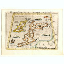
Tabula Europae I (Great Britain).
Nice example of the rare third state of Ruscelli's map of the British Isles, based Claudius Ptolemy.The map first appeared in the 1561 edition of Ruscelli's edition of Pt...
Date: Basel, Heinrich Petri, 1545
Selling price: ????
Please login to see price!
Sold in 2017
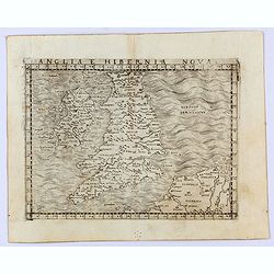
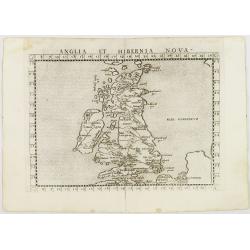
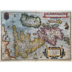
Anglia e Hibernia Nova
Gastaldi's modern map of the British Isles. It is one of the earliest obtainable modern maps of the British Isles.From Giacomo Gastaldi's Atlas of 1548, which has been ca...
Date: Venice, 1548
Selling price: ????
Please login to see price!
Sold in 2021
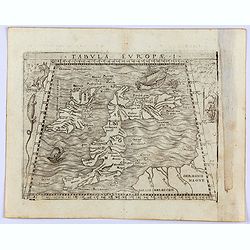
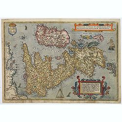
Tabula Europae I. (British Isles)
Gastaldi's map of the British Isles is based on Ptolemy.┬ĀIt is one of the earliest obtainable maps of the region.From Giacomo Gastaldi's Atlas of 1548, which has been ca...
Date: Venice, 1548
Selling price: ????
Please login to see price!
Sold in 2021
Das Engelland, mit dem anstossenden Reich Schottland. . . Britannia. . .
An antique map of England and Wales, with parts of Scottland and Ireland. Full title : Engellandt/ mit dem anstossenden Reich Schottlandt/ so vor zeiten Albion und Britan...
Date: Basel ca 1550
Selling price: ????
Please login to see price!
Sold in 2020
Beschreibung Engellandts und Schottlandts.
A full-page woodcut map of England, Scotland, Wales, and part of Ireland, published in Basel, circa 1550. This charming woodblock map of Britain is the base for the Merca...
Date: Basel, ca 1550
Selling price: ????
Please login to see price!
Sold in 2021
Anglia et Hibernia Nova. . .
Uncommon first edition of one of the earliest maps of Great Britain.Girolamo Ruscelli's edition of Ptolemy's Geographia included newly engraved copperplates by Giulio and...
Date: Venice, 1561
Selling price: ????
Please login to see price!
Sold in 2008
Britania Insula quae dup Regna continet Angliam et Scotiam cum Hibernia adiacente. Ferando Berteli exc. 1561. Venise: 1562
One of the earliest printed maps of England. The essential roots of mid-16th century mapping of the British Isles go back to the English catholic priest George Lily (ca 1...
Date: Venice, 1564
Selling price: ????
Please login to see price!
Sold
Britannischen Insula.
An unusual outline of the British Isles, influenced by Ptolemy.
Date: Basle, 1570
Selling price: ????
Please login to see price!
Sold in 2016
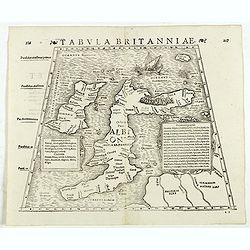
Tabula Britanniae. (British Isles)
Double-page woodcut Ptolemaic-style map by Sebastian M├╝nster, showing the British Isles, published in the edition of Strabo by Henri Petri in 1571."Strabonis rerum ...
Date: Basle, Henri Petri, 1571
Selling price: ????
Please login to see price!
Sold in 2018
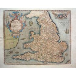
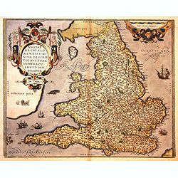
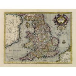
Angliae Regni flo: rentissimi nova descriptio, auctore Humfredo Lhuyd.
Stunning map of England and Wales compiled from Mercator's 1564 wall map of the British Isles and Lhuyd's manuscript map of 1568. The countryside is fully engraved with t...
Date: Antwerp, 1573
Selling price: ????
Please login to see price!
Sold in 2017
Anglia et Hibernia Nova. . .
One of the earliest maps of Great Britain.Girolamo Ruscelli's edition of Ptolemy's Geographia included newly engraved copperplates by Giulio and Livio Sanuti. From the se...
Date: Venice, 1574
Selling price: ????
Please login to see price!
Sold in 2009
![Tabula Europae I [British Isles].](/uploads/cache/42111-250x250.jpg)
Tabula Europae I [British Isles].
An early double page Ptolemaic map of the British Isles from 'La Geografia Di Claudio Tolomeo Alessandrino...' published by G. Ziletti, Venice (using plates from the 1561...
Date: Venice, 1574
Selling price: ????
Please login to see price!
Sold in 2019
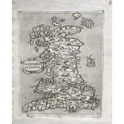
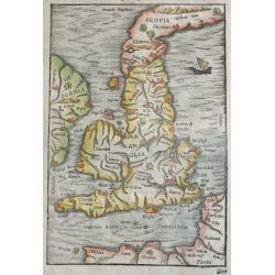
INGILTERRA ET SCOTIA.
One of the earliest modern Maps of England, Wales & Scotland. A very rare early map of England, Wales and Scotland, with topography and main settlements, depicted pic...
Date: Venice, 1570-1575
Selling price: ????
Please login to see price!
Sold in 2022
Angliae Scotiae et Hibernie nova descriptio.
FIRST EDITION of this fine example of De Jode's rare map of the British Isles, oriented with West at the top. The map was based on Mercator's wall map from 1554. From the...
Date: Antwerp 1578
Selling price: ????
Please login to see price!
Sold
Engellandt/ mit dem anstossenden Reich Schottlandt/ so vorzeiten Albion und Britannia haben geheissen.
From 'Cosmographia, das ist: Beschreibung der Gantzen Welt,...'; German edition. wood engravings set into text; overall size 33 x 20 cm. on verso: engraved title. M├╝nst...
Date: Basle, c. 1578
Selling price: ????
Please login to see price!
Sold in 2015
Beschreibung Engellandts und Schottlandts.
From 'Cosmographia, das ist: Beschreibung der Gantzen Welt,...'; published in Basle, c1578, German edition.wood engraving set into text; overall size 33 x 20 cm. On verso...
Date: Basle, c. 1578
Selling price: ????
Please login to see price!
Sold in 2015
Das Engellandt/ mit dem anstossenden Reich Schottland/ so vorzeiten Albion und Britannia/ haben geheissen.
A woodcut map; on laid paper. This map is from the last German edition of the well-published 'Cosmographia', with Scotland orientated to the West. The map is decorated wi...
Date: Basle, 1578
Selling price: ????
Please login to see price!
Sold in 2016
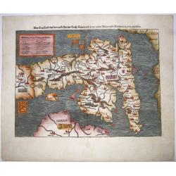
Beschreibung Engellands und Schottlandts
A very early and attractively coloured map of the UK, Engeland, Schotland, Ireland, and Wales, on a full leaf. A wonderful woodcut with picturesquely cut cities, seas and...
Date: Basel, 1578
Selling price: ????
Please login to see price!
Sold in 2021
Anglia et Hibernia Nova. . .
One of the earliest maps of Great Britain.Girolamo Ruscelli's edition of Ptolemy's Geographia included newly engraved copperplates by Giulio and Livio Sanuti. From the se...
Date: Venice, 1579
Selling price: ????
Please login to see price!
Sold in 2013
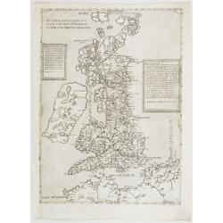
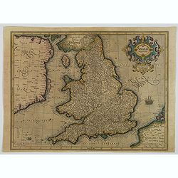
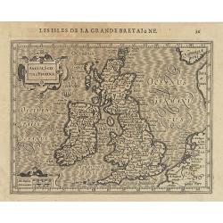
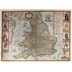
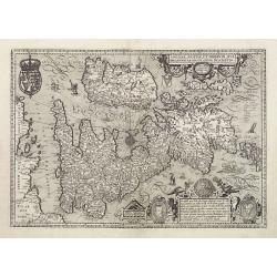
Anglia, Scotiae et Hiberniae, Sive Brittannicar: Insularum Descriptio
A classic and famous map of the British Isles with North to the right.Probably the earliest map of the British Isles that are still available. Despite the fact, that the ...
Date: Antwerp, 1579
Selling price: ????
Please login to see price!
Sold in 2019
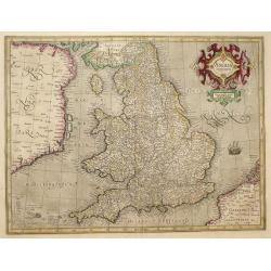
Angliae Regni flo: rentissimi nova descriptio, auctore Humfredo Lhuyd.
From the Theatrum Orbis Terrarum - French Text - this is Humphrey Lloyd's depiction of England and Wales published in the first Additamentum to the Ortelius atlas. The m...
Date: Antwerp, 1581
Selling price: ????
Please login to see price!
Sold in 2013
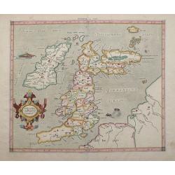
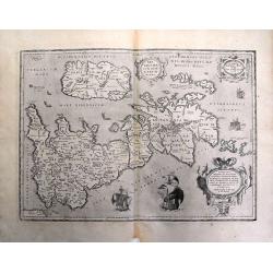
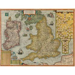
Angliae, scotiae, et Hiberniae, sive Britannicar insularum.
A state 3 of this classic, handsome and decorative map of ancient British Isles with north orientated to the east. Latin text on verso.Based on Mercator's 1564 map of the...
Date: Antwerp, after 1584
Selling price: ????
Please login to see price!
Sold in 2018
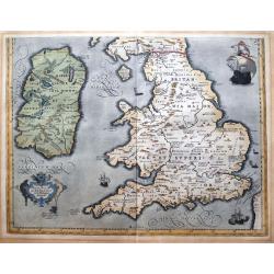
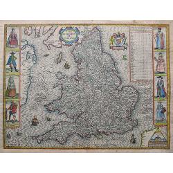
Angliae, scotiae, et Hiberniae, sive Britannicar insularum.
A classic, handsome and decorative map of ancient British Isles with north orientated to the east. Based on Mercator's 1564 map of the British isles and improved by Saxto...
Date: Antwerp, 1587
Selling price: ????
Please login to see price!
Sold in 2014
Angliae, scotiae, et Hiberniae, sive Britannicar : insularum descriptio.
A classic, handsome and decorative map of ancient British Isles with north orientated to the east. Based on Mercator's 1564 map of the British isles and improved by Saxto...
Date: Antwerp, 1587
Selling price: ????
Please login to see price!
Sold in 2017
Anglia
Miniature map covering England and Wales. French text on verso. This map is oriented with north to the right. The map is beautifully engraved with stippled seas and ships...
Date: Antwerp, 1588
Selling price: ????
Please login to see price!
Sold
Engellandt / mit dem anstossenden Reich Schottlandt / so vor zeiten Albion und Britannia haben geheissen.
Early map of England and the British Isles. The map is oriented with west at the top and provides a fine early depiction of the British Isles, based upon Ortelius' map of...
Date: Basle, S.H. Petrie, 1588
Selling price: ????
Please login to see price!
Sold in 2014
Anglia.
Map of Great Britain.From a German text edition of his Cosmographia , that great compendium of Renaissance knowledge.
Date: Basle 1550-1590
Selling price: ????
Please login to see price!
Sold
Engellandt mit dem anstossenden Reich Schottlandt so vor zeiten Albion und Britannia haben geheissen.
A decorative map of Great Britain and eastern part of Ireland. Oriented to the west. Tablet in lower right corner with a brief commentary in German. Two ships and a sea-c...
Date: Basle, 1590
Selling price: ????
Please login to see price!
Sold in 2010
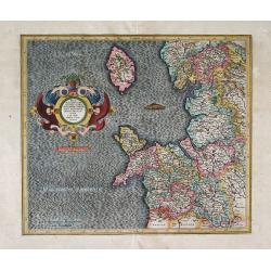
Tab. I. Europae Continens Albion, Britanniam, et Hiberniam.
MercatorŌĆÖs map of Great Britain, based on PtolemyŌĆÖs Geographia. This map is from the 1584 edition of his Tabulae Geographicae. The ancient map of the British Isles ha...
Date: Cologne, Amsterdam, 1590
Selling price: ????
Please login to see price!
Sold in 2012
![[British Isles ]](/uploads/cache/32517-250x250.jpg)
[British Isles ]
On recto an early birds-eye view of Great Britain. Cornwall is depicted as an entity on an equal footing as Wales and Scotland.From a Latin text edition of his Geographia...
Date: Basle, 1550-1590
Selling price: ????
Please login to see price!
Sold in 2013
Brittanicarum Insularum Vetus Descriptio.
Southern part of Ortelius important two-sheet map of the British Isles. Includes Ireland, Wales, the Isle of Man, and England. Shows the Hadrian's Wall. Richly decorated ...
Date: Antwerp, c1590
Selling price: ????
Please login to see price!
Sold in 2013
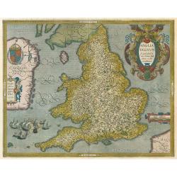
Angliae Regni Florentissimi Nova Descriptio, Auctore Humfredo Lhuyd Denbygiense. 1573.
Attractive map of England and Wales compiled from Mercator's 1564 wall map of the British Isles and Lhuyd's manuscript map of 1568. The countryside is fully engraved with...
Date: Antwerp, 1592
Selling price: ????
Please login to see price!
Sold in 2012
ANGLIAE, SCOTIAE ET HIBERNIAE, SIVE BRITANNICAR: INSVLARVM DESCRIPTIO.
A beautiful map of the British Isles, north to the right. The map is based on Mercator's earlier map of the British Isles of 1564. Title in strapwork cartouche at top rig...
Date: Antwerp 1592
Selling price: ????
Please login to see price!
Sold in 2016
Angliae, Scotiae et Hibernie Nova Descriptio.
Rare map of the British Isles in original color from De Jode's Speculum orbis terrae. Oriented with West at the top. The map was based on Mercator's wall map from 1554. G...
Date: Antwerp, 1593
Selling price: ????
Please login to see price!
Sold in 2009
Angliae, Scotiae et Hibernie Nova Descriptio.
Rare map of the British Isles in original color from De Jode's Speculum orbis terrae. Oriented with West at the top. The map was based on Mercator's wall map from 1554. G...
Date: Antwerp, 1593
Selling price: ????
Please login to see price!
Sold in 2010
Angliae Regni flo: rentissimi nova descriptio, auctore Humfredo Lhuyd Cum Privilego.
Map by Humphrey Lloyd, Denbigh with coast shaded sea borders, rivers, hillocks, forests and towns. Published by Abraham Ortelius. The map presents an interesting picture ...
Date: Antwerp, 1595
Selling price: ????
Please login to see price!
Sold in 2016
Anglia regnum.
A finely engraved map of England published during the last years of the reign of Elizabeth I, filled with names taken from the earlier Christopher Saxton map of 1579. Wit...
Date: Duisburg, ca 1595
Selling price: ????
Please login to see price!
Sold in 2023
![Anglia, Regnum si quod aliud in toto Oceano ditissimuin et florentissimum. [imprints] Christophorus Saxton describedat, J.le Clerc ex.](/uploads/cache/28412-250x250.jpg)
Anglia, Regnum si quod aliud in toto Oceano ditissimuin et florentissimum. [imprints] Christophorus Saxton describedat, J.le Clerc ex.
Rare map of England, with elaborate title cartouche, and Royal coat-of-arms A close copy of the Saxton (c.1543-1610) / Ortelius map of 1603, however slightly smaller. Acc...
Date: Paris, 1602
Selling price: ????
Please login to see price!
Sold in 2009
Anglia Regnum si quod aliud in toto Oceano ditissimum et florentissimum.
Rare England map by Ortelius. Latin text on verso.
Date: Antwerp, 1603
Selling price: ????
Please login to see price!
Sold in 2009
Anglia.
Miniature map of England and Wales from Ortelius-Coignet atlas published by Hulsius in Frankfurt after Abraham Ortelius. The title is contained in a strapwork cartouche.I...
Date: Frankfurt, 1604
Selling price: ????
Please login to see price!
Sold in 2014
Anglia regnum.
Counties are shown in outline and named. The coast of Ireland is shown across the Irish Sea.Mercator was born in Rupelmonde in Flanders and studied in Louvain under Gemma...
Date: Amsterdam 1606
Selling price: ????
Please login to see price!
Sold
Anglia Regnum.
A map of England from the Mercator's Atlas III. 1606 latin edition.A finely engraved map of Elizabethan England filled with names taken from the Saxton map of 1579. Merca...
Date: Amsterdam, 1606
Selling price: ????
Please login to see price!
Sold in 2015
Anglia.
An attractive miniature map of Anglia (England & Wales), published by Petrus Bertius, in Amsterdam at the beginning of the seventeenth century.Anglia is seen 'lying o...
Date: Amsterdam, 1606
Selling price: ????
Please login to see price!
Sold in 2020
![[An accurate picture of a male neighbour of a Pict].](/uploads/cache/39417-250x250.jpg)
[An accurate picture of a male neighbour of a Pict].
The male neighbours of the Picts wore cloth cassocks or jerkins. They grew their hair and moustaches long but shaved their chins. Around their waists they had girdles fro...
Date: Frankfurt, 1607
Selling price: ????
Please login to see price!
Sold in 2017
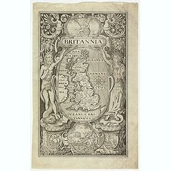
(Title page) Britannia.
Very attractive and decorative early 17th century frontispiece from Camden's Britannia.Below the title, a map of Britain, inscribed with the Latin names places and tribes...
Date: London, W.Hole, ca. 1607
Selling price: ????
Please login to see price!
Sold in 2017
Anglia Sco:tia et Hibernia.
Map of the British Isles from the first French-text edition of Jodocus Hondius' Atlas Minor.Shortly after the publication of the big folio-atlases the need was apparently...
Date: Amsterdam, 1608
Selling price: ????
Please login to see price!
Sold in 2016
Britannicarum Insularum Typus.
Decorative and rare map of the British Isles in Roman times. Based on information from Mercator's 1564 map of the British Isles, improved by a new outline from Saxton's 1...
Date: Antwerp, ca. 1608
Selling price: ????
Please login to see price!
Sold in 2016
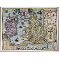
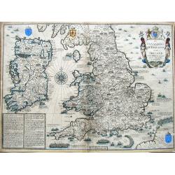
Angliae et Hiberniae.
A rare early map of England and Ireland (and part of Scotland) in perfect condition. Full title in a small cartouche middle top: 'ANGLIAE ET HIBERNIAE | ACCVRATA DESCRIPT...
Date: Antwerp, 1608
Selling price: ????
Please login to see price!
Sold in 2020
Angliae et Hiberniae Accurata Decriptio. . .
One of the most decorative and rare maps of Great Britain and Ireland by Jan Baptist Vrients (1552-1612) in original color. The map first appeared in 1606, and this is st...
Date: Antwerp, 1609
Selling price: ????
Please login to see price!
Sold in 2020
Brittanicarum Insularum Typus. 1595.
A map of Roman Britain based on information from Mercator's 1564 map of the British Isles, improved by a new outline from Saxton's 1579 map, and ancient knowledge from Di...
Date: Antwerp, 1609
Selling price: ????
Please login to see price!
Sold in 2021
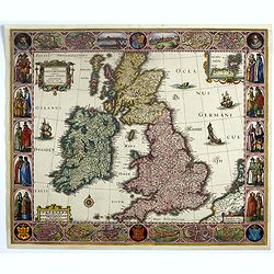
The Kingdome of England
The most famous and iconic map of England in the Stuart period. Rare first state of the map. Handsome copper engraved map from Speed's "Theatre of the Empire of Grea...
Date: London, 1610
Selling price: ????
Please login to see price!
Sold in 2015
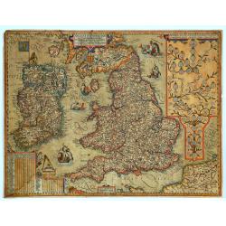
Angliae et Hiberniae Accurata descriptio.
Rare Johann Baptist Vrients map of England and Wales including a genealogical tree from William the Conqueror to the time of publication and James I. The map first appear...
Date: Antwerp, 1612
Selling price: ????
Please login to see price!
Sold in 2009
The Kingdome of England.
Rare first edition of Speed's carte-a-figures map engraved by Hondius and published John Sudbury & George Humble. This famous map of England & Wales is flanked by...
Date: London, ca. 1612
Selling price: ????
Please login to see price!
Sold in 2017
WEST MORLANDIA, LANCASTRIA, CESTRIA, CAERNARVAN, DENBIGH, FLINT, MERIONIDH, MONTGOMERY, SALOPIA Cum insulis MANIA ET ANGLESEY, Per Gerardum Mercatorem.
A fine, early decorative map by Gerard Mercator of northwest England. There is great clarity in the placement and list of numerous cities and towns on the map. At the l...
Date: Duisburg and then Amsterdam, (1595-1602) 1613
Selling price: ????
Please login to see price!
Sold in 2013
Angliae, Scotiae, et Hiberniae, sive Britannicar : Insularum descriptio.
A rare and ornate map with inset portraits of James First, Henry Prince of Wales Princess Anne of Denmark.Janssonius acquired the copperplate of van den Keere's 1604 Brit...
Date: Amsterdam 1621
Selling price: ????
Please login to see price!
Sold

Anglia Scotia et Hibernia.
Small map of Great Britain and Ireland, surrounded by text in Dutch.Nicolaes de Clerck (de Klerc) was active as engraver and publisher in Delft from 1599-1621.Included in...
Date: Amsterdam, Cloppenburch, 1621
Selling price: ????
Please login to see price!
Sold in 2010
Anglia Scotia et Hibernia.
Small map of Great Britain and Ireland, surrounded by text in Dutch.Nicolaes de Clerck (de Klerc) was active as engraver and publisher in Delft from 1599-1621.Included in...
Date: Amsterdam, Cloppenburch, 1621
Selling price: ????
Please login to see price!
Sold in 2017
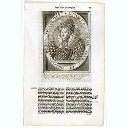
Elisabet D. G. Angliae, Franciae, Et Hiberniae, Regina, Fid. Chr. Prop.
The engraving depicts a half length oval portrait of Elizabeth I (1533 ŌĆō 1603) was Queen of England and Ireland from 17 November 1558 until her death. Sometimes called ...
Date: Amsterdam, Cloppenburch, 1621
Selling price: ????
Please login to see price!
Sold in 2016
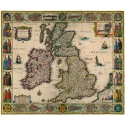
Tabula Magnae Britanniae continens Angliam Scotiam et Hiberniam.
A very rare and decorative carte-├Ā-figures map in a first state. Prof. Schilder locates only 8 other copies !.Interestingly, the map has extensive contemporary annotatio...
Date: Amsterdam, 1625
Selling price: ????
Please login to see price!
Sold in 2010
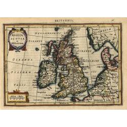
Angliae Scotiae et Hiberniae sive Britannicarum Insularum &
Uncommon map of England, Scotland and Ireland, engraved by David Custos.
Date: Augsburg 1627
Selling price: ????
Please login to see price!
Sold
The Invasions of England and Ireland with al their Civill Wars Since the Conquest.
A fantastic map of England, Wales and Ireland that illustrates all the notable battles since the Norman Conquest (including Hastings in 1066, Bosworth Field in 1485 and F...
Date: London, ca. 1627
Selling price: ????
Please login to see price!
Sold in 2019
Anglia Scotia et Hibernia.
Nice map of the British Isles and Ireland showing the major cities. Large strapwork title cartouche. Latin text on verso.
Date: Amsterdam 1628
Selling price: ????
Please login to see price!
Sold
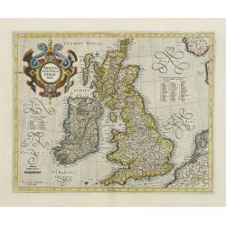
Anglia, Scotia et Hibernia.
Early map of the British Isles. Mercator used the maps of England and Wales from Saxton, Ireland partly from Nowell-Hondius and Scotland from his own map of 1564. This wa...
Date: Amsterdam 1630
Selling price: ????
Please login to see price!
Sold
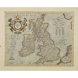
Anglia, Scotia et Hibernia.
Early map of the British Isles. Mercator used the maps of England and Wales from Saxton, Ireland partly from Nowell-Hondius and Scotland from his own map of 1564. This wa...
Date: Amsterdam, 1630
Selling price: ????
Please login to see price!
Sold in 2008
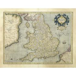
Anglia regnum.
Counties are shown in outline and named. The coast of Ireland is shown across the Irish Sea.Mercator was born in Rupelmonde in Flanders and studied in Louvain under Gemma...
Date: Amsterdam, 1630
Selling price: ????
Please login to see price!
Sold in 2025
Tabula Magnae Britanniae continens Angliam Scotiam..
Extremely rare map of the British Isles designed by Claes Janszoon Visscher some time in the early 1620s. The engraving is by Abraham Goos. This is the later state with t...
Date: Amsterdam, c.1630
Selling price: ????
Please login to see price!
Sold in 2023
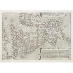
Magnae Britanniae et Hiberniae Tabula.
A finely engraved, boldly embellished map of the British Isles from the most important Dutch map publishers of the 17th century, densely packed with information.It includ...
Date: Amsterdam 1631
Selling price: ????
Please login to see price!
Sold
Anglia Regnum.
A later edition of the map that first appeared in Part III of the Mercator Atlas published in Duisburg 1595: The main differences are the cartouch and the size of The Isl...
Date: Duisburg/Amsterdam, 1595/1633
Selling price: ????
Please login to see price!
Sold in 2014
![[L'Hermite's fleet moors in the Solent for repairs].](/uploads/cache/41116-250x250.jpg)
[L'Hermite's fleet moors in the Solent for repairs].
In March 1623, a heavily armed fleet of 11 ships, under the command of Jacob lŌĆÖHermite, sailed from Holland with the ambitious hope of ŌĆśdestroying the Spanish in Amer...
Date: Frankfurt, M.Merian, 1633
Selling price: ????
Please login to see price!
Sold in 2018
Anglia Regnum.
FIRST EDITION, FIRST ISSUE OF THIS MAP. A scarce first edition (often listed as proof state) of Willem Blaeu's map of England and Wales. Blaeu was the first publisher to ...
Date: Amsterdam, 1634
Selling price: ????
Please login to see price!
Sold in 2015
