Browse Listings in Europe > British Isles > Channel Islands
![[Showing the 1588 defeat of the Spanish Armada in the English Channel]](/uploads/cache/20220907_173700-250x250.jpg)
[Showing the 1588 defeat of the Spanish Armada in the English Channel]
Beautiful engraving by Michael Eytzinger, showing the 1588 defeat of the Spanish Armada in the English Channel. Latin text on verso. Published in Leonis Belgici Descript...
Date: Cologne, ca. 1590
Selling price: ????
Please login to see price!
Sold in 2022
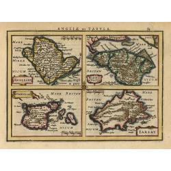
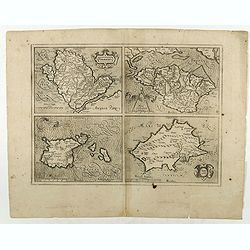
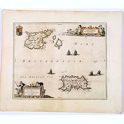
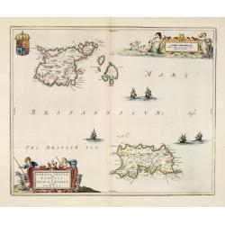
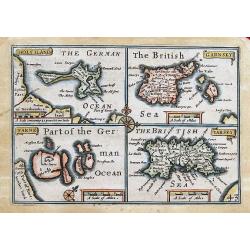
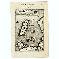
Anglesey, Wight, Garnesey, Iarsay.
This is a reduced version of Mercator's folio map with four maps on one sheet depicting the English islands of Jersey, Guernsey, Wright and Alderney. Each map is embellis...
Date: Amsterdam 1628
Selling price: ????
Please login to see price!
Sold
Anglesey Ins. / Wight.. / Ins. Garnesey. / Ins. Iarsey.
Four maps on one sheet depicting the English islands of Jersey, Guernsey, Wright and Alderney. Mercator was born in Rupelmonde in Flanders and studied in Louvain under Ge...
Date: Amsterdam, 1630
Selling price: ????
Please login to see price!
Sold in 2011
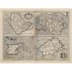
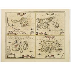
Anglesey Ins. / Wight.. / Ins. Garnesey. / Ins. Iarsey.
Four maps on one sheet depicting the English islands of Jersey, Guernsey, Wright and Alderney. Mercator was born in Rupelmonde in Flanders and studied in Louvain under Ge...
Date: Amsterdam, 1630
Selling price: ????
Please login to see price!
Sold in 2015
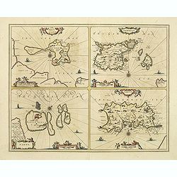
Holy Iland. Garnsey. Farne. Iarsey.
Showing the islands in the Channel.Mercator was born in Rupelmonde in Flanders and studied in Louvain under Gemma Frisius, Dutch writer, astronomer and mathematician. The...
Date: Amsterdam, 1630
Selling price: ????
Please login to see price!
Sold in 2020
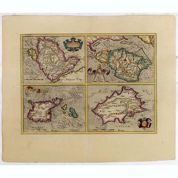
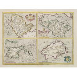
Anglesey. / Iarsay. / Carnesay. / Wight Vectis Olim.
Four maps on one sheet depicting the English islands Jersey, Guernsey, Wright and Alderney.No text on verso. From a French composite atlas.Read more about Dutch - French ...
Date: Amsterdam, 1630
Selling price: ????
Please login to see price!
Sold in 2018
Holy Iland. Garnsey. Farne. Iarsey.
Showing the islands in the Channel.Mercator was born in Rupelmonde in Flanders and studied in Louvain under Gemma Frisius, Dutch writer, astronomer and mathematician. The...
Date: Amsterdam 1630
Selling price: ????
Please login to see price!
Sold in 2009
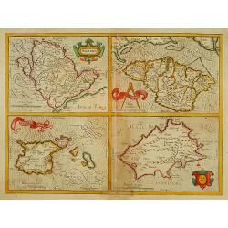
Anglesey. / Iarsay./Garnesay. / Wight Vectis Olim.
Four maps on one sheet depicting the English islands Jersey, Guernsey, Wright and Alderney.
Date: Amsterdam, 1642
Selling price: ????
Please login to see price!
Sold in 2021
Anglesey./Iarsay./Garnesay./ Wight Vectis Olim.
Four maps on one sheet depicting the English islands Jersey, Guernsey, Wright and Alderney.
Date: Amsterdam 1639-1644
Selling price: ????
Please login to see price!
Sold
Sarnia insula vulgo Garnsey et Insula Caesarea. . . Garnsey. . .
Fine decorative map depicting the English Channel Islands of Jersey and Guernsey.Taken from Joan Blaeu's French edition Le Theatre du Monde, ou Nouvelle Atlas, Mise en l...
Date: Amsterdam, 1645
Selling price: ????
Please login to see price!
Sold in 2017
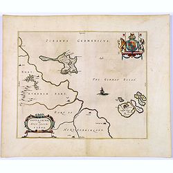
Insula Sacra, Vulgo Holy Iland, et Farne.
Double-page map of Holy Island and Farne Island off the coast of Northumberland. The Abbey, the Old Fort and the town are clearly marked. Latin text on verso.Taken from J...
Date: Amsterdam, 1645
Selling price: ????
Please login to see price!
Sold in 2018
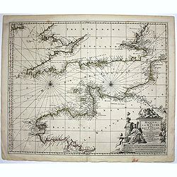
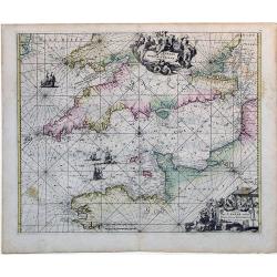
Manica, gallis La Manche, et belgis Het Canaal.
Chart of the English Channel. Stretching from "Belle Isle" lower center, to Cardigan, top left- and Colchester, top right-hand side.
Date: Amsterdam, 1660
Selling price: ????
Please login to see price!
Sold in 2014
Sarnia Insula vulgo Garnsey et Insula Caesarea venacule Jarsey.
Very fine map depicting the English islands Jersey and Guernsey. Decorative cartouche with a shepherd, a shepherdess and sheep.The crown on top of the coat of arms height...
Date: Amsterdam, 1660
Selling price: ????
Please login to see price!
Sold in 2014
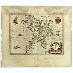
Comitatus Caernarvoniensis, Vernacule Carnarvon-Shire et Mona Insula Vulgo Anglesey.
One of the most decorative maps of Caernarvonshire and Anglesey with present-day Gwynedd and Mon. The map is embellished with the Royal Arms, the crest and feathered crow...
Date: Amsterdam, 1661
Selling price: ????
Please login to see price!
Sold in 2020
HOLYILAND; GARNSEY; FARNE; IARSEY;
"Miniature Speed" four maps one page: of Holy Island and Lindisfarne, the Channel Islands: Guernsey (including Herm & Sark) and Jersey. Very charming maps, ...
Date: London, 1666
Selling price: ????
Please login to see price!
Sold in 2013
Isle de Wigh. (Isle of Wight)
A charming map of the Isle of Wight. Title in curtain draped at top. French text on verso.From the original 1683 text edition of "Description d'Univers. . ." by...
Date: Paris, 1683
Selling price: ????
Please login to see price!
Sold in 2022
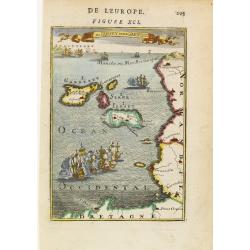
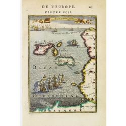
Is de Jersey et de Garnesey.
A fine and uncommon early 18th century birds-eye view of Jersey and Guernsey. Numerous tall masted ships may be seen, including two engaged in battle in the foreground.Fr...
Date: Paris 1683
Selling price: ????
Please login to see price!
Sold
Isle de Man et d'Anglesey. (Isles of Man and Anglesey.)
A charming map of the Islands of Man and Anglesey. Title in curtain draped at top. French text on verso.From the original 1683 text edition of "Description d'Univers...
Date: Paris, 1683
Selling price: ????
Please login to see price!
Sold in 2020
Is de Jersey et de Garnesey.
A fine and uncommon early 18th century birds-eye view of Jersey and Guernsey. The North Sea filled with numerous ships.From the French text edition of Description d'Unive...
Date: Paris, 1683
Selling price: ????
Please login to see price!
Sold
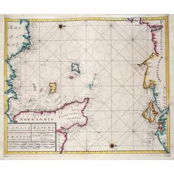
Nieuwe Zeekaart van het Tweede gedeelte van het Canaal Tusschen Engeland en Vrankryk. / ...Chanell betwext England and France.
A detailed chart of the Channel with the coasts of Normandy and part of Bretagne with Guernsy and Jersey and the south coast of England between Chichester and Exmouth wit...
Date: Amsterdam, ca 1685
Selling price: ????
Please login to see price!
Sold in 2019
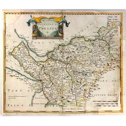
The County Palatine of Chester ...
This is the county map of Cheshire by Robert Morden. It shows an early road system with the town of Chester located on the left middle side of the map. There is a decorat...
Date: London, 1695
Selling price: ????
Please login to see price!
Sold in 2016
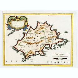
Iarsey Isola, gia detta Caesarea appartenente al Re d'Ingliterra.
An attractive small map of Jersey in the Channel Islands, with decorative cartouche from the Atlante Veneto: Isolario descrittione geografico-historia, published in Venic...
Date: Venice, 1696
Selling price: ????
Please login to see price!
Sold in 2020
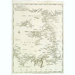
![[No tittle] The Sea Coasts south of England and Brittany in France.](/uploads/cache/29447-250x250.jpg)
[No tittle] The Sea Coasts south of England and Brittany in France.
Detailed of the Channel with Cornwall and Brittany.
Date: London, c.1700
Selling price: ????
Please login to see price!
Sold in 2011
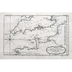
Carte de la Manche.
A large detailed sea chart of the English Channel has the coast of England from Cornwall round to Suffolk and South Wales. Below is the coast of France from La Baie de Do...
Date: Amsterdam, 1710
Selling price: ????
Please login to see price!
Sold in 2016
Canalis inter Angliae et Galliae Littera (English Channel)
This map was originally made and published by Frederick de Wit. The plate was acquired by the Ottens brothers after the death of De Wit's son in 1706. Following the gener...
Date: Amsterdam, ca. 1725
Selling price: ????
Please login to see price!
Sold in 2010
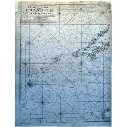
A Large Chart of The Channell Between England And France.
A striking nautical chart detailing of the channel between England and France.
Date: London, 1740
Selling price: ????
Please login to see price!
Sold in 2010
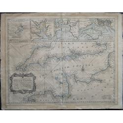
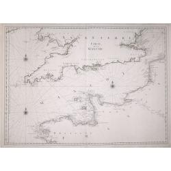
A correct Chart of the English Channel - From the No. Foreland to the Lands End on the Coast of England, and from Calais to Brest on the Coast of France . . .
The English Channel, featuring insets of the Isles of Scilly, Falmouth Haven, Plymouth Sound and the Isle of Wight and ye adjacent Harbours. Alderney, Guernsey, Jersey an...
Date: London, 1747
Selling price: ????
Please login to see price!
Sold in 2020
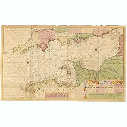
Nieuwe paskaart vande geheele canaal tufschen engeland en vranckryck.
This rare chart shows the Chanel between England et France. With explanation cartouche and ornamentally surrounded title-cartouche, fivefold miles indicator, current arro...
Date: Amsterdam, 1728 - 1751
Selling price: ????
Please login to see price!
Sold in 2016
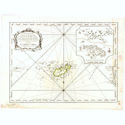
Carte reduite de l'isle d'Aurigni et des isles et roches voisines dressée au Depost des Cartes et Plans . . .
Sea of Guernsey.Relief shown by hachures. Depths shown by soundings. It shows soundings, anchorage's, channels, shoals, navigational sightings.
Date: Paris, 1757
Selling price: ????
Please login to see price!
Sold in 2015
Costes de France depuis Brest jusqu'a Dunkerque...
An interesting chart of the Channel with the English and French coasts. Extends from Bristol to Cornwall, all the way to London and Kent in England; and from Brest to Par...
Date: Paris, 1761
Selling price: ????
Please login to see price!
Sold in 2017
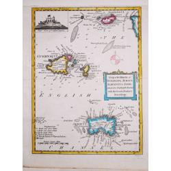
Antique map of the Channel Islands.
A nice antique map of the Channel Islands, published in the English Gentleman's Magazine. Inset at top left of Cornet Castle. Mileage scale.
Date: London, 1779
Selling price: ????
Please login to see price!
Sold in 2020
A New and Correct Chart of the Islands of Jersey, Guernsey, Alderney...
A detailed map of the Channel Islands, and sections of Brittany and Normandy, from the Neville to the Isles of Brehat. Included in the Political Magazine , engraved by Lo...
Date: London 1781
Selling price: ????
Please login to see price!
Sold in 2016
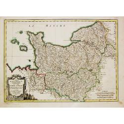
Carte du Gouvernement de Normandie avec celui du Maine et Perche.
Jean Lattré, Paris-based engraver and publisher. Worked with Robert de Vaugondy, J. Janvier and R. Bonne. "Atlas Monderne", 1771, 1783 , 1793. Rigobert Bonne (...
Date: Paris, 1783
Selling price: ????
Please login to see price!
Sold in 2018
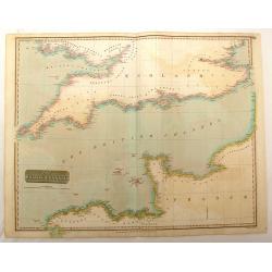
The British Channel.
Fine hand-colored map of the English Channel from John Thomson,s "GENERAL ATLAS" published in 1814. Engraved and signed in print by J & G Menzies.
Date: Edinburgh, 1814
Selling price: ????
Please login to see price!
Sold in 2016
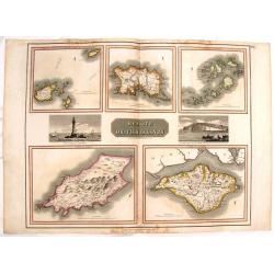
Remote British Islands.
Large, hand-colored map of Great Britain's remote islands including Wight, Scilly, Mann, Guernsey & Jersey. There are also two fine engravings of island scenes.
Date: Edinburgh, 1817
Selling price: ????
Please login to see price!
Sold in 2016
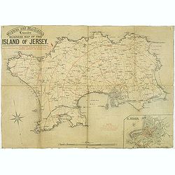
Stephens and Mackintosh Leicester. Business map of the island of Jersey.
Map of Jersey. it shows the principal roads, plus street plan St. Helier inserted in the lower right corner. Showing the distance from St. Helier in red among a key to ab...
Date: Leicester, ca. 1898
Selling price: ????
Please login to see price!
Sold in 2019
