Browse Listings in Europe > British Isles
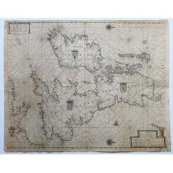
Pas-Caart vant Canaal Vertoonende in 't Gheheel Engelandt, Schotlandt, Yrlandt, en een Gedeelte van Vrancryck.
A fine chart of the British Isles. North is oriented to the right. Embellished with two compass roses, a galleon under sail and four national coats of arms. This chart ap...
Date: Amsterdam, 1665-1666.
Selling price: ????
Please login to see price!
Sold in 2020
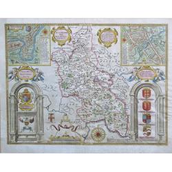
Buckinghamshire.
An attractive map of Buckinghamshire from the "Theatre of Great Britaine" by John Speed, published by Thomas Bassett and Richard Chiswell with two interesting i...
Date: London, 1676
Selling price: ????
Please login to see price!
Sold in 2020
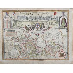
BARKSHIRE DESCRIBED.
Original copperplate engraved map printed on handmade paper, with original hand coloring. A spectacular pictorial of WINDSOR CASTLE across the top of this decorative map....
Date: London, 1710
Selling price: ????
Please login to see price!
Sold in 2013
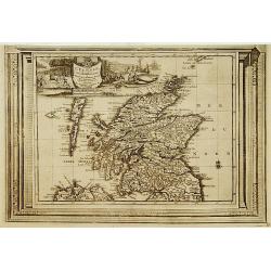
L'Ecosse, suivant les nouvelles observations..
With decorative title cartouche upper left corner.This example is unusual in having the additional separately engraved decorative framework border around the map, the res...
Date: Amsterdam 1728.
Selling price: ????
Please login to see price!
Sold
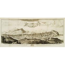
The North Prospect of the City of Edinburgh.
A very fine and quite large view of Edinburgh from Joannes Kip's Britannia Illustrata or Views of Several of the Queens Palaces also of the Principal Seats of the Nobilit...
Date: London 1708-20
Selling price: ????
Please login to see price!
Sold
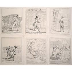
(Complete set of 6) A London Nuisance.
Scarce and amusing series of 6 plates depicting the dangers of the London streets.Complete set of 6 "A London Nuisance", etchings by Richard Dighton, plates 1-6...
Date: London, 1821
Selling price: ????
Please login to see price!
Sold in 2026
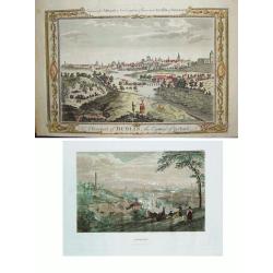
LOT of 2: 1) A Prospect of Dublin the Capital of Ireland 2) Dublin
Two wonderful views of Dublin offered as one lot. Item 1) shows the Liffey River winding through the city. The foreground is filled with citizens, some wealthy and othe...
Date: Item 1) London, ca. 1780. Item 2) Philadelphia, dated 1838.
Selling price: ????
Please login to see price!
Sold in 2010

A set of 12 prints of the country seats of the Noblemen & Gentlemen of Ireland
A set of 12 original 1870 color prints from The Rev. F.O. Morris work ŌĆ£A Series of Picturesque Views of Seats of the Noblemen & Gentlemen of Great Britain and Irela...
Date: London & Dublin, 1870
Selling price: ????
Please login to see price!
Sold in 2017
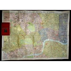
Gall & Inglis Reduced Ordnance Map of London
A large scale folding map of London, published in London by Gall & Inglis in the form of a pocket book. The map is backed, both sides, and the main map is in full ori...
Date: London, 1890
Selling price: ????
Please login to see price!
Sold in 2016
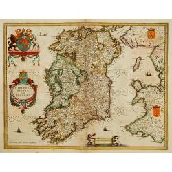
Hibernia regnum vulgo Ireland.
Fine map of Ireland with large coat of arms.
Date: Amsterdam 1639-44
Selling price: ????
Please login to see price!
Sold
![Scotiae pars Septentrionalis. [2 Maps]](/uploads/cache/16215-250x250.jpg)
Scotiae pars Septentrionalis. [2 Maps]
Detailed map in two sheets depicting the Northern part of Scotland.
Date: Amsterdam 1639-44
Selling price: ????
Please login to see price!
Sold
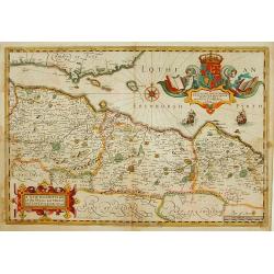
A New Description of the Shyres Lothian and Linlitquo. Be T.Pont.
A Scottish clergyman, Timothy Pont's survey of Scotland of 1595-1608 made that country the best mapped in the world. However it was not until Blaeu issued the maps as Vol...
Date: Amsterdam 1639-44
Selling price: ????
Please login to see price!
Sold
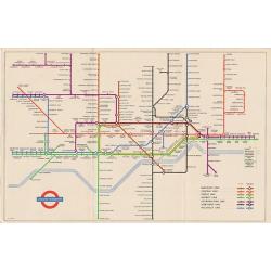
4 London Transport related maps.
ŌĆśRailways Diagram of LinesŌĆÖ dated January 1951 (The London Underground) 225 x 150 mm.ŌĆśBus Map Country AreaŌĆÖ June 1952, 570 x 430 mm.ŌĆśBus Map Central Area Includ...
Date: London, 1951 -1952
Selling price: ????
Please login to see price!
Sold in 2016
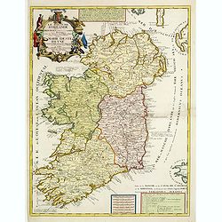
Le Royaume d'Irlande..
Uncommon map of Ireland. A visually stunning map with a large title cartouche. This large one-sheet map was produced by the Venetian cosmographer Vincenzo Coronelli when ...
Date: Paris 1690 / CORONELLI,P.
Selling price: ????
Please login to see price!
Sold
