Browse Listings in Europe > British Isles
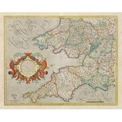
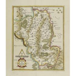
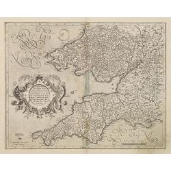
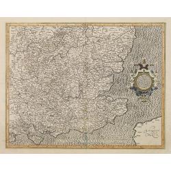
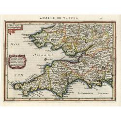
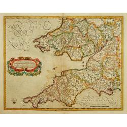
Cornubia, Devonia, Somersetus,..
A very nice map showing the south-western part of England.Mercator was born in Rupelmonde in Flanders and studied in Louvain under Gemma Frisius, Dutch writer, astronomer...
Date: Amsterdam 1630
Selling price: ????
Please login to see price!
Sold
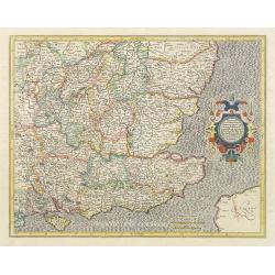
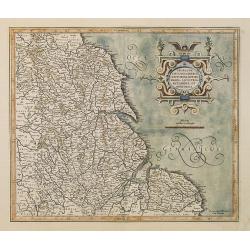
Warwicum, Northhamtonia, Huntingdonia, Cantabrigia..
Nice map of south-eastern England. Includes London, Salisbury, Oxford, Cambridge, Leicester and Norwich and the Isle of Wight. Strapwork title cartouche and scale of mile...
Date: Amsterdam 1630
Selling price: ????
Please login to see price!
Sold
Warwicum, Northhamtonia, Huntingdonia..
Nice map of south-eastern England. Includes London, Salisbury, Oxford, Cambridge, Leicester and Norwich and the Isle of Wight. Strap work title cartouche and scale of mil...
Date: Amsterdam, 1630
Selling price: ????
Please login to see price!
Sold in 2008
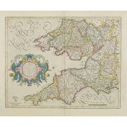
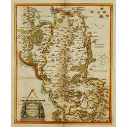
Cornubia, Devonia, Somersetus,..
A very nice map showing the south-western part of England.Mercator was born in Rupelmonde in Flanders and studied in Louvain under Gemma Frisius, Dutch writer, astronomer...
Date: Amsterdam, 1630
Selling price: ????
Please login to see price!
Sold in 2012
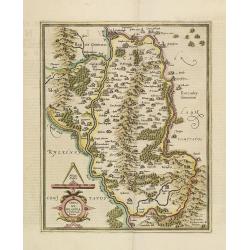
Udrone Irlandiae in Catherlagh Baronia.
Depicts present day County Carlow in Leinster Province and Catherlaugh which is now Carlow.The title is surrounded by a strapwork design cartouche topped with calipers &a...
Date: Amsterdam, 1630
Selling price: ????
Please login to see price!
Sold
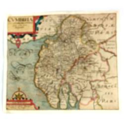
West Morlandia, Lancastria..
Showing the north-western part of England, including the Island of Man.Mercator was born in Rupelmonde in Flanders and studied in Louvain under Gemma Frisius, Dutch write...
Date: Amsterdam, 1630
Selling price: ????
Please login to see price!
Sold in 2009
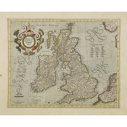
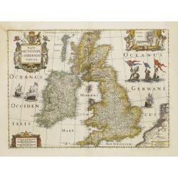
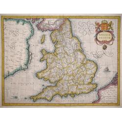
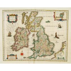
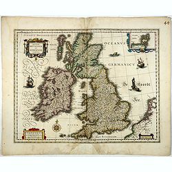
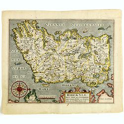
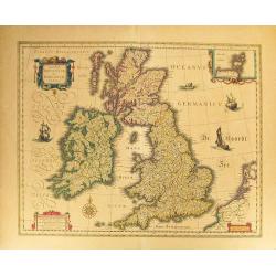
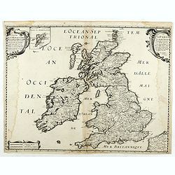
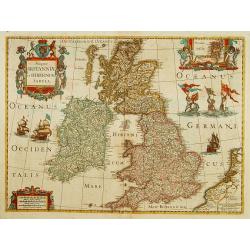
Anglia, Scotia et Hibernia.
Early map of the British Isles. Mercator used the maps of England and Wales from Saxton, Ireland partly from Nowell-Hondius and Scotland from his own map of 1564. This wa...
Date: Amsterdam, 1630
Selling price: ????
Please login to see price!
Sold in 2008
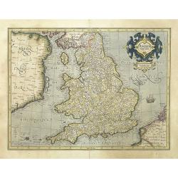
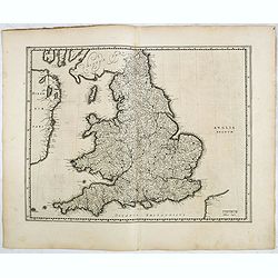
Anglia regnum.
Counties are shown in outline and named. The coast of Ireland is shown across the Irish Sea.Mercator was born in Rupelmonde in Flanders and studied in Louvain under Gemma...
Date: Amsterdam, 1630
Selling price: ????
Please login to see price!
Sold in 2025
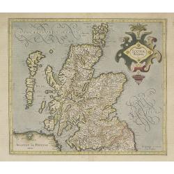
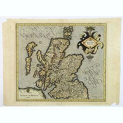
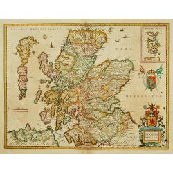
Scotia Regnum.
Detailed map of Scotland. This map was to remain the standard map of Scotland, until a new map by Robert Gordon was published in 1654 (Shirley, p. 78).Mercator was born i...
Date: Amsterdam, 1630
Selling price: ????
Please login to see price!
Sold in 2015
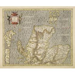
Scotiae regnum.
Detailed two-sheet map of Scotland.Mercator was born in Rupelmonde in Flanders and studied in Louvain under Gemma Frisius, Dutch writer, astronomer and mathematician. The...
Date: Amsterdam, 1630
Selling price: ????
Please login to see price!
Sold in 2016
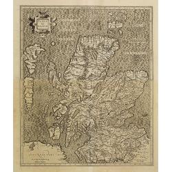
Scotiae regnum.
Detailed map of Scotland, made of 2 maps pasted together.Mercator was born in Rupelmonde in Flanders and studied in Louvain under Gemma Frisius, Dutch writer, astronomer ...
Date: Amsterdam, 1630
Selling price: ????
Please login to see price!
Sold in 2010
Cornubia, Devonia, Somersetus, . . .
A very nice map showing the south-western part of England.Mercator was born in Rupelmonde in Flanders and studied in Louvain under Gemma Frisius, Dutch writer, astronomer...
Date: Amsterdam, 1630
Selling price: ????
Please login to see price!
Sold in 2011
Warwicum, Northhamtonia, Huntingdonia..
Nice map of south-eastern England. Includes London, Salisbury, Oxford, Cambridge, Leicester and Norwich and the Isle of Wight. Strap work title cartouche and scale of mil...
Date: Amsterdam, 1630
Selling price: ????
Please login to see price!
Sold in 2010
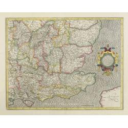
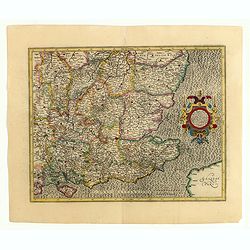
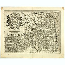
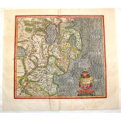
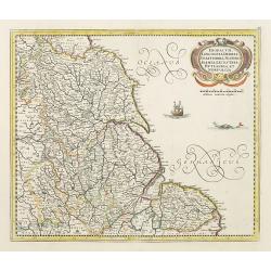
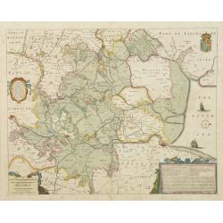
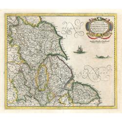
Eboracum, Lincolnia, Derbia, Staffordia, etc.
Map of the eastern part of England from about Middleborough to Yarmouth, inland to include Coventry, Nottingham, Sheffield, Leeds, and York.Mercator was born in Rupelmond...
Date: Amsterdam, 1630
Selling price: ????
Please login to see price!
Sold in 2011

West Morlandia, Lancastria. . .
Showing the north-western part of England, including the Island of Man.Mercator was born in Rupelmonde in Flanders and studied in Louvain under Gemma Frisius, Dutch write...
Date: Amsterdam, 1630
Selling price: ????
Please login to see price!
Sold in 2010
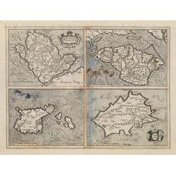
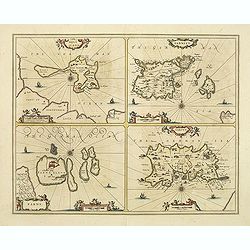
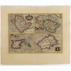
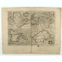
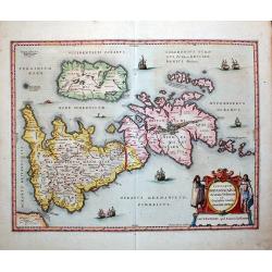
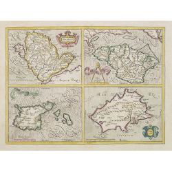
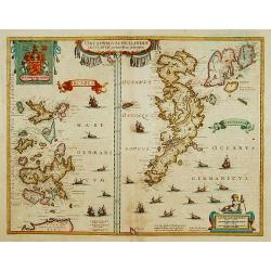
Anglesey Ins. / Wight.. / Ins. Garnesey. / Ins. Iarsey.
Four maps on one sheet depicting the English islands of Jersey, Guernsey, Wright and Alderney. Mercator was born in Rupelmonde in Flanders and studied in Louvain under Ge...
Date: Amsterdam, 1630
Selling price: ????
Please login to see price!
Sold in 2011
Udrone Irlandiae in Catherlagh Baronia.
Depicts present day County Carlow in Leinster Province and Catherlaugh which is now Carlow.The title is surrounded by a strapwork design cartouche topped with calipers &a...
Date: Amsterdam, 1630
Selling price: ????
Please login to see price!
Sold in 2011
Holy Iland. Garnsey. Farne. Iarsey.
Showing the islands in the Channel.Mercator was born in Rupelmonde in Flanders and studied in Louvain under Gemma Frisius, Dutch writer, astronomer and mathematician. The...
Date: Amsterdam, 1630
Selling price: ????
Please login to see price!
Sold in 2020
Brightstowe in Engelland (Bristol)
An attractive and unusual , from Daniel Meisner's 'Sciagraphica Cosmica'. Copper engraved print, showing a bird's-eye view of Bristol, with its castle, within the city wa...
Date: Nuremberg, ca. 1630
Selling price: ????
Please login to see price!
Sold in 2011
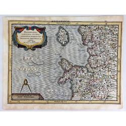
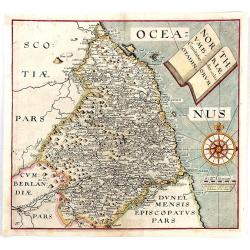
Northumbria, Cumberlandia et Dunelmensis Episcopatus.
Showing the most northern part of England.Mercator was born in Rupelmonde in Flanders and studied in Louvain under Gemma Frisius, Dutch writer, astronomer and mathematici...
Date: Amsterdam, c. 1630
Selling price: ????
Please login to see price!
Sold in 2014
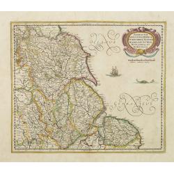
Eboracum, Lincolnia, Derbia, Staffordia, Notinghamia. . .
Map of the eastern part of England from about Middlesbrough to Yarmouth, inland to include Coventry, Nottingham, Sheffield, Leeds, and York. Title cartouche in a banner h...
Date: Amsterdam, 1630
Selling price: ????
Please login to see price!
Sold in 2022
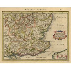
Warwicum Northamtonia Huntingdonia Cantabrigia..
Showing the south-eastern part of England.
Date: Amsterdam, 1630
Selling price: ????
Please login to see price!
Sold in 2015
Anglesey Ins. / Wight.. / Ins. Garnesey. / Ins. Iarsey.
Four maps on one sheet depicting the English islands of Jersey, Guernsey, Wright and Alderney. Mercator was born in Rupelmonde in Flanders and studied in Louvain under Ge...
Date: Amsterdam, 1630
Selling price: ????
Please login to see price!
Sold in 2015
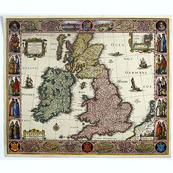
Tabula Magnae Britanniae continens Angliam Scotiam..
Extremely rare map of the British Isles designed by Claes Janszoon Visscher some time in the early 1620s. The engraving is by Abraham Goos. This is the later state with t...
Date: Amsterdam, c.1630
Selling price: ????
Please login to see price!
Sold in 2023
Westmorlandia, Lancastria, Cestria, Caerarvan, Denbigh, Fun, Merionidh, Montgomery,SA.
Striking map of North West England and Isle of Man by Mercator / Hondius in 1630. It is from the "Atlas Minor". Features attractive title cartouche and scale ca...
Date: Amsterdam, 1630
Selling price: ????
Please login to see price!
Sold in 2018
Scotia Regnum.
A lovely detailed map of Scotland. This map was to remain the standard map of Scotland, apart from some minor improvements by Speed, until a new map by Robert Gordon in 1...
Date: Amsterdam, 1630
Selling price: ????
Please login to see price!
Sold in 2018
Anglesey. / Iarsay. / Carnesay. / Wight Vectis Olim.
Four maps on one sheet depicting the English islands Jersey, Guernsey, Wright and Alderney.No text on verso. From a French composite atlas.Read more about Dutch - French ...
Date: Amsterdam, 1630
Selling price: ????
Please login to see price!
Sold in 2018
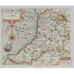
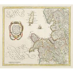
Cardigan Comitatus pars Olim Dimetarum.
A fine map of the Welsh county of Cardiganshire from William Camden's great Renaissance work 'Britannia'. Engraved by William Kip after Christopher Saxton in about 1630. ...
Date: London, 1630
Selling price: ????
Please login to see price!
Sold in 2023
Northumbria, Cumberlandia et Dunelmensis Episcopatus.
Showing the most northern part of England.Mercator was born in Rupelmonde in Flanders and studied in Louvain under Gemma Frisius, Dutch writer, astronomer and mathematici...
Date: Amsterdam, 1630
Selling price: ????
Please login to see price!
Sold in 2020
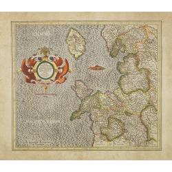
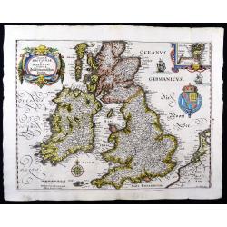
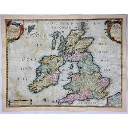
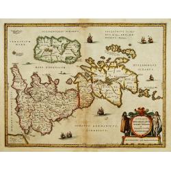
Magnae Britanniae et Hiberniae Tabula.
A finely engraved, boldly embellished map of the British Isles from the most important Dutch map publishers of the 17th century, densely packed with information.It includ...
Date: Amsterdam 1631
Selling price: ????
Please login to see price!
Sold
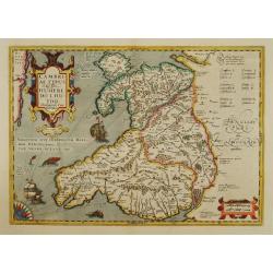
Cambriae Typus..
Ancient map of Wales, prepared by Humphrey Lhuyd. With fine cartouche, part of a compass-rose and a sea monster.
Date: Amsterdam 1633
Selling price: ????
Please login to see price!
Sold
A New Description of the Shyres Lothian and Linlitquo. Be T.Pont.
A Scottish clergyman, Timothy Pont's survey of Scotland of 1595-1608 made that country the best mapped in the world. However it was not until Blaeu issued the maps as Vol...
Date: Amsterdam, 1633
Selling price: ????
Please login to see price!
Sold in 2011
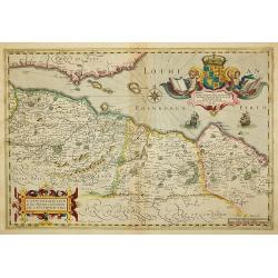
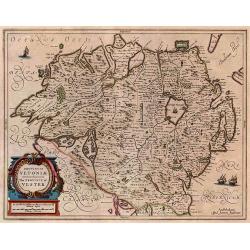
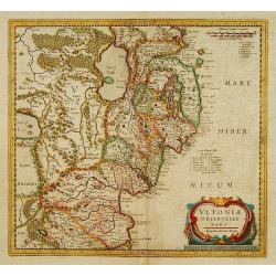
Ultoniae Orientalis Pars.
Early map featuring the Down & Antirm counties of Northern Ireland. Interesting, decorative combination title / scale cartouche and the sea is in moire pattern. Frenc...
Date: Amsterdam, 1633
Selling price: ????
Please login to see price!
Sold in 2015
Anglia Regnum.
A later edition of the map that first appeared in Part III of the Mercator Atlas published in Duisburg 1595: The main differences are the cartouch and the size of The Isl...
Date: Duisburg/Amsterdam, 1595/1633
Selling price: ????
Please login to see price!
Sold in 2014
![[L'Hermite's fleet moors in the Solent for repairs].](/uploads/cache/41116-250x250.jpg)
[L'Hermite's fleet moors in the Solent for repairs].
In March 1623, a heavily armed fleet of 11 ships, under the command of Jacob lŌĆÖHermite, sailed from Holland with the ambitious hope of ŌĆśdestroying the Spanish in Amer...
Date: Frankfurt, M.Merian, 1633
Selling price: ????
Please login to see price!
Sold in 2018
Warwicum..
Nice map of south-eastern England. Includes London, Salisbury, Oxford, Cambridge, Leicester and Norwich and the Isle of Wight. Strapwork title cartouche and scale of mile...
Date: Amsterdam 1634
Selling price: ????
Please login to see price!
Sold
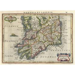
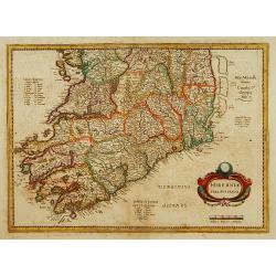
Momonia et Lagenia.
Nice map of the Southern part of Ireland. Decorated with a small strapwork title cartouche and a monster in the Ocean. Latin text on verso.
Date: Amsterdam 1634
Selling price: ????
Please login to see price!
Sold
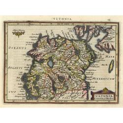
Ultonia, Conatia et Media.
This small map provides a detailed view of Northern Ireland and includes a handsome title cartouche. Latin text on verso.
Date: Amsterdam 1634
Selling price: ????
Please login to see price!
Sold
Cornubia, Devonia,..
Nice map Southwest England and South Wales. Decorated with a small strapwork title cartouche. Latin text on verso.
Date: Amsterdam 1634
Selling price: ????
Please login to see price!
Sold
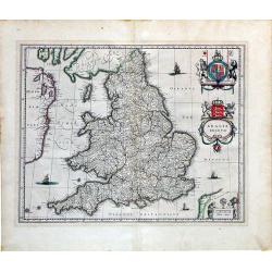
Anglia Regnum.
FIRST EDITION, FIRST ISSUE OF THIS MAP. A scarce first edition (often listed as proof state) of Willem Blaeu's map of England and Wales. Blaeu was the first publisher to ...
Date: Amsterdam, 1634
Selling price: ????
Please login to see price!
Sold in 2015
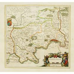
Middle-Sexia.
A finely engraved map of the area north of London, from the most important Dutch map publishers of the 17th century.
Date: Amsterdam 1635
Selling price: ????
Please login to see price!
Sold
Magnae Britanniae et Hiberniae Tabula.
A finely engraved map from the most important Dutch map publishers of the 17th century. The plate was acquired by the Blaeu's from Jodocus Hondius Jr. in 1629, and was re...
Date: Amsterdam 1635
Selling price: ????
Please login to see price!
Sold
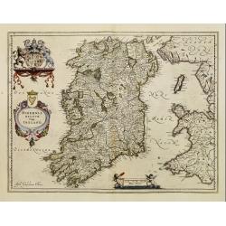
Hibernia regnum vulgo Ireland..
Standard map of Ireland embellished with decorative coat of arms, cartouche with title and a scale cartouche showing two putti.
Date: Amsterdam, 1635
Selling price: ????
Please login to see price!
Sold
Magnae Britanniae et Hiberniae Tabula.
A finely engraved map from the most important Dutch map publishers of the 17th century. The plate was acquired by the Blaeu's from Jodocus Hondius Jr. in 1629, and was re...
Date: Amsterdam, 1635
Selling price: ????
Please login to see price!
Sold in 2017
Insularum Britannicarum Acurata Delineatio ex Geographicis Conatibus Abraham Ortelii by Jan Jansson 1636 First state
Attractive original Scarce first state of Jansson's map of the Ancient British Isles. Includes decorative cartouche, sea monsters and 7 sailing vessels. Engraved by Peter...
Date: Amsterdam, 1636
Selling price: ????
Please login to see price!
Sold in 2011
Magnae Britanniae et Hiberniae Tabulae
A handsome map of Britain and Ireland, published by M. Merian in Frankfurt in 1636.Merian based this map on Blaeu's influential earlier work and he added a Stuart coat of...
Date: Frankfurt, 1636
Selling price: ????
Please login to see price!
Sold in 2023
Viri Clarissimi Britannia..
A very attractive and decorative early 17th century map of Ireland which appeared in William Camden's Britannia. Based on Mercator's map of 1595, it was engraved by Willi...
Date: London, W.Hole, ca. 1637
Selling price: ????
Please login to see price!
Sold in 2015
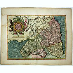
Cumbria Sive Cumberlandia Quae Olim par Brigantum.
A pleasing map of Cumberland from ŌĆ£CamdenŌĆÖs BritanniaŌĆØ. The 'Britannia' was the first publication that contained a complete set of individual county maps of England...
Date: London, 1610-1637
Selling price: ????
Please login to see price!
Sold in 2016
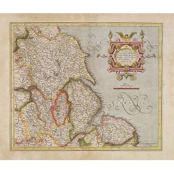
Northumbriae Comitatus, Olim Sedes Otadinorum.
An attractive map of Northumberland based on the first survey of England and Wales by Christopher Saxton and published in William Camden's ŌĆ£BRITANNIAŌĆØ (London: 1607-...
Date: London, 1610-1637
Selling price: ????
Please login to see price!
Sold in 2016
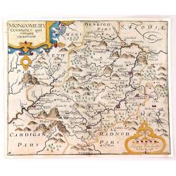
Montgomery Comitatus Qui Osim Pars Ordovicum.
Fine copper engraving of the county of Montgomery in England. The title is in a strapwork cartouche. Prepared and engraved by William Kip and William Hole based on Chris...
Date: London, 1637
Selling price: ????
Please login to see price!
Sold in 2016
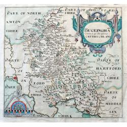
Buckingha Comitatus, in quo olim insederunt Cattieuchlani.
A fine early map of Buckinghamshire engraved by William Hole after Christopher Saxton. From the 1607 or 1637 edition of Camden's 'Britannia'. Very detailed, extending fro...
Date: London, 1637
Selling price: ????
Please login to see price!
Sold in 2020
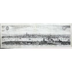
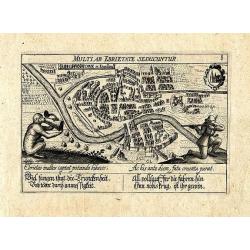
London
A panoramic, early view of London before the fire 1666, it has a key noting 43 places within the City. This large view extends from the King's Palace at Whitehall to the ...
Date: Frankfurt, 1638
Selling price: ????
Please login to see price!
Sold in 2016
Provincia Ultoniae The Province of Ulster.
A finely engraved map of Ulster in northern Ireland. Adorned with vessels and a decorative title cartouche. Relief shown pictorially. Illustrated topography shows towns, ...
Date: Amsterdam, 1638
Selling price: ????
Please login to see price!
Sold in 2017
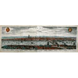
London.
A panoramic, early view of London before the fire of 1666, it has a key noting 43 places within the City. This large view extends from the King's Palace at Whitehall to ...
Date: Frankfurt a. M., 1638
Selling price: ????
Please login to see price!
Sold in 2019
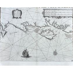
De Custen van Engelandt tuschen de droochte van Weembrugh en Poortlandt
Rare sea-chart from Blaeu's Zeespiegel. It shows the area around the Isle of Wight, from Weymouth and the Isle of Portland to Selsey and Chichester, including Poole, Sout...
Date: Amsterdam, ca. 1638
Selling price: ????
Please login to see price!
Sold in 2022
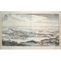
Edynburgum.
From Merian's "Topographia," a beautifully presented panoramic view of Edinburgh in the mid 17th century. Edinburgh Castle is shown in the left portion of the p...
Date: Frankfurt, ca. 1640
Selling price: ????
Please login to see price!
Sold
Anglia Regnum.
A striking map of Great Britain with two finely-engraved coats of arms (Great Britain and Ireland).
Date: Amsterdam, ca. 1640
Selling price: ????
Please login to see price!
Sold in 2010
De Custen van Engeland en Schotlandt tusschen Tinbij en de Eijlanden van Orcanesse.
Very rare of the coasts of Scotland, with Aberdeen, from The New Fierie Sea-Colomne, published in 1640 by Jacob Aertz. Colom. .
Date: Amsterdam, 1640
Selling price: ????
Please login to see price!
Sold in 2010
Magnae Britanniae et Hiberniae Tabula.
First issued in 1630 with vignette borders depicting costumes and towns; however, that state only appeared that year after which the borders were cropped from the plate, ...
Date: Amsterdam, [1631] - 1640
Selling price: ????
Please login to see price!
Sold in 2012
Carte Generale des Royaume d'Angleterre Ecosse et Irlande...
A striking first edition copperplate map of the British Isles by Sanson, on his own slightly eccentric projection. Engraved by Melchior Tavernier in Paris in 1640. Featur...
Date: Paris, 1640
Selling price: ????
Please login to see price!
Sold in 2017
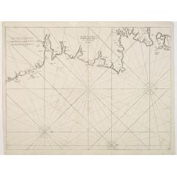
Irlandiae Mari Portus.
Sea chart of Ireland, from Werdenhagen J., De Rebus Publicis Hanseaticis Tractatus.
Date: Frankfurt, 1641
Selling price: ????
Please login to see price!
Sold in 2009
Eboracum, Lincolnia, Derbia, Staffordia, Notinghamia..
Showing the north-eastern part of England. Ornamental title cartouche in the upper right corner. Embellished with a vessel and a sea monster.
Date: Amsterdam 1642
Selling price: ????
Please login to see price!
Sold
Westmorlandia Lancastria, Cestria, Caernarvan, Denbigh..
Showing the north-western part of England, including the Island of Man, Liverpool, Blackpool, etc.Embellished with ornamental title cartouche and a vessel.
Date: Amsterdam 1642
Selling price: ????
Please login to see price!
Sold in 2009
A general Plott and description of the Fennes..
Fine map depicting the area north of Cambridge, up to King's Lynn. West to the top.
Date: Amsterdam, 1642
Selling price: ????
Please login to see price!
Sold in 2020
Eboracum, Lincolnia, Derbia, Staffordia, Notinghamia..
Showing the north-eastern part of England.
Date: Amsterdam, 1642
Selling price: ????
Please login to see price!
Sold in 2009
Anglesey. / Iarsay./Garnesay. / Wight Vectis Olim.
Four maps on one sheet depicting the English islands Jersey, Guernsey, Wright and Alderney.
Date: Amsterdam, 1642
Selling price: ????
Please login to see price!
Sold in 2021
![[Two maps] Hiberniae pars Australis. . .](/uploads/cache/08341-250x250.jpg)
[Two maps] Hiberniae pars Australis. . .
Fine two sheet map of Ireland, with impressive topographical information, with several keys. Prepared by Mercator, published by Janssonius / Hondius.Mercator's two-sheet ...
Date: Amsterdam, 1642
Selling price: ????
Please login to see price!
Sold in 2019
Insularum Britannicarum acurata delineatio. . .
A map of the Roman Britain as seen during the third and fourth centuries. Roman place names as well as Hadrian's Wall and the Wall of Pius appear on the map, identifying ...
Date: Amsterdam, 1642
Selling price: ????
Please login to see price!
Sold in 2022
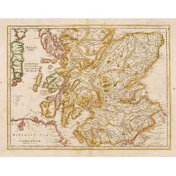
No title: Scotland.
Detailed map of Scotland with Glasgow (Glasquo) in center.
Date: Amsterdam, 1642
Selling price: ????
Please login to see price!
Sold in 2018
Carte Generale des Royaume d'Angleterre Escosse et Irlande Avecq les Isles circonvoisines Conues toutes soubs le nom de Britanniques / Nouvellement dressee et tiree de Cambdene Spede & autres Par N. Sanson geogr.e Ord.re du Roy.
Fine example of Nicolas Sanson's first map of the British Isles, engraved by Melchior Tavernier. A small inset map shows the Shetland Isles. The distortion of Ireland and...
Date: Paris, 1642
Selling price: ????
Please login to see price!
Sold in 2018
Eboracum, Lincolnia, Derbia, Staffordia, Notinghamia...
An elegant map of northeast England by Henricus Hondius, published out of Amsterdam during the golden age of Dutch map making in 1642.┬ĀThe map presents the English count...
Date: Amsterdam, 1642
Selling price: ????
Please login to see price!
Sold in 2023
Udrone Irlandiae in Catherlagh Baronia.
Depicts present day County Carlow in Leinster Province & Catherlaugh which is now Carlow. The title is surrounded by a strap work design cartouche topped with caliper...
Date: Amsterdam 1639-1644
Selling price: ????
Please login to see price!
Sold
Ultoniae orientatlis pars.
Showing Northern Ireland with Lough Neagh and Belfast. Signed lower right hand corner Sumptibus Henrici Hondy.Henricus Hondius re-issued Mercator's map with a new title c...
Date: Amsterdam 1639-1644
Selling price: ????
Please login to see price!
Sold
Two maps: Hiberniae pars Australis/..
Fine map of Ireland in two parts. Prepared by Mercator, published by Henricus Hondius. Mercator's name erased.
Date: Amsterdam 1639-1644
Selling price: ????
Please login to see price!
Sold
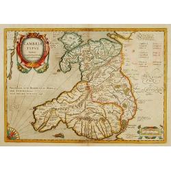
Cambriae Typus.
Ancient map of Wales, prepared by Humphrey Lhuyd. With fine cartouche, part of a compass-rose and a sea monster.
Date: Amsterdam 1639-1644
Selling price: ????
Please login to see price!
Sold
Insularum Britannicarum acurata delineatio..
A map of the Roman Britain as seen during the third and fourth centuries. Roman place names as well as Hadrian's Wall and the Wall of Pius appear on the map, identifying ...
Date: Amsterdam 1639-1644
Selling price: ????
Please login to see price!
Sold
Magnae Britanniae et Hiberniae Tabula.
A finely engraved map from the most important Dutch map publishers of the 17th century.
Date: Amsterdam 1639-1644
Selling price: ????
Please login to see price!
Sold
Scotia Regnum.
A attractive example of this fine map of Scotland. In upper right hand corner inset of Orkney Islands.
Date: Amsterdam 1639-1644
Selling price: ????
Please login to see price!
Sold
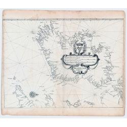
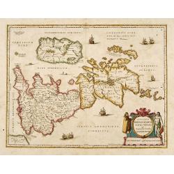
Orcadum et Schetlandiae insularum..
Two maps on one sheet. Showing the Orkney- and Shetland Islands.
Date: Amsterdam 1639-1644
Selling price: ????
Please login to see price!
Sold
Lot of 5 maps of the English counties.
Lot of 5 maps of the English counties.
Date: Amsterdam 1639-1644
Selling price: ????
Please login to see price!
Sold
