Browse Listings in Europe > British Isles
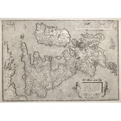
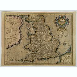
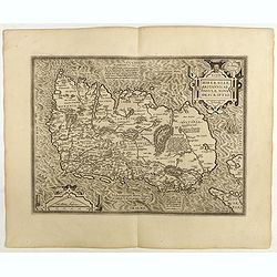
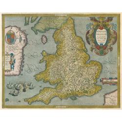
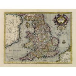
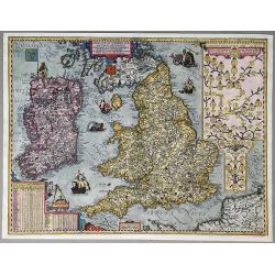
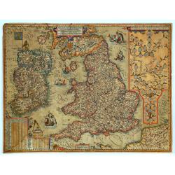
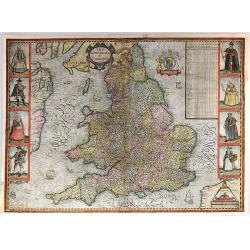
ANGLIAE, SCOTIAE ET HIBERNIAE, SIVE BRITANNICAR: INSVLARVM DESCRIPTIO.
A beautiful map of the British Isles, north to the right. The map is based on Mercator's earlier map of the British Isles of 1564. Title in strapwork cartouche at top rig...
Date: Antwerp 1592
Selling price: ????
Please login to see price!
Sold in 2016
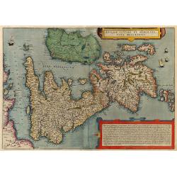
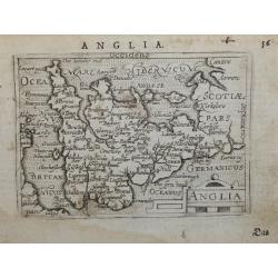
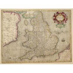
Angliae, Scotiae et Hibernie Nova Descriptio.
Rare map of the British Isles in original color from De Jode's Speculum orbis terrae. Oriented with West at the top. The map was based on Mercator's wall map from 1554. G...
Date: Antwerp, 1593
Selling price: ????
Please login to see price!
Sold in 2009
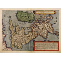
Angliae, Scotiae et Hibernie Nova Descriptio.
Rare map of the British Isles in original color from De Jode's Speculum orbis terrae. Oriented with West at the top. The map was based on Mercator's wall map from 1554. G...
Date: Antwerp, 1593
Selling price: ????
Please login to see price!
Sold in 2010
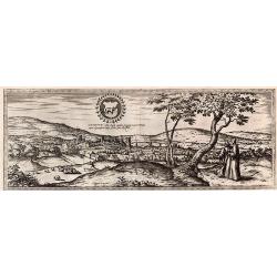
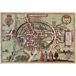
Oxonium nobile Anglie oppidum...
A decorative view of Oxford, from Braun & Hogenberg's "Civitatus Orbis Theatrum", the most famous atlas of city views published in the 16th Century. A fine ...
Date: Cologne, 1593
Selling price: ????
Please login to see price!
Sold in 2017
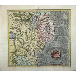
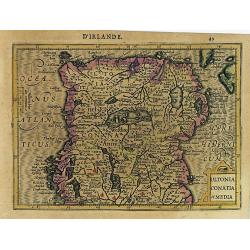
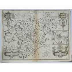
Ultoniae Orientalis Par.
Decorative map of the Ulster Region.From the first edition of Mercator's Atlas, published in 1595. The map features an ornate title cartouche with a scale below. The map...
Date: Duisberg, 1595
Selling price: ????
Please login to see price!
Sold
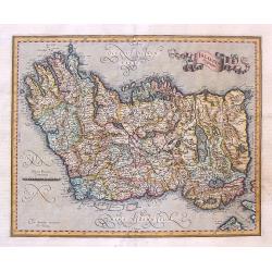
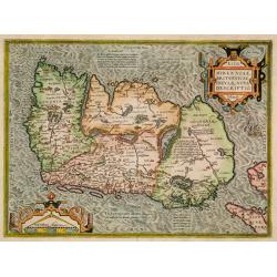
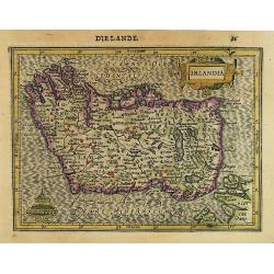
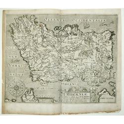
Irlandia Regnum.
Striking map of Ireland, with north oriented to the right and featuring a splendid ribbon style title banner cartouche. Fully engraved with topographical features and a s...
Date: Amsterdam, 1595
Selling price: ????
Please login to see price!
Sold in 2017
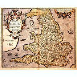
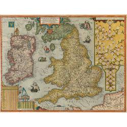
Angliae Regni flo: rentissimi nova descriptio, auctore Humfredo Lhuyd Cum Privilego.
Map by Humphrey Lloyd, Denbigh with coast shaded sea borders, rivers, hillocks, forests and towns. Published by Abraham Ortelius. The map presents an interesting picture ...
Date: Antwerp, 1595
Selling price: ????
Please login to see price!
Sold in 2016
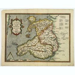
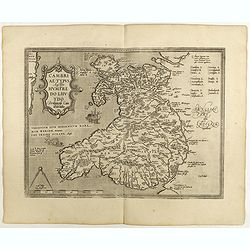
Cambriae Typus Auctore Humfredo Lhuydo Denbigiense Cambrobritano.
A beautiful hand colored copper-engraved map of Wales. It is the first separately printed map of Wales, by Humphrey Lhuyd. This is the second variant of the Ortelius publ...
Date: Antwerp, ca 1595
Selling price: ????
Please login to see price!
Sold in 2019
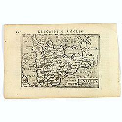
Anglia regnum.
A finely engraved map of England published during the last years of the reign of Elizabeth I, filled with names taken from the earlier Christopher Saxton map of 1579. Wit...
Date: Duisburg, ca 1595
Selling price: ????
Please login to see price!
Sold in 2023
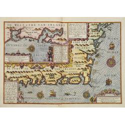
Beschrivinge der zeecusten van de Z├╝ijtsijde ende de Oos t-sijde van Irlandt. . . .
A detailed chart of the coast of the western side of Ireland. Decorated by a title cartouche and scale cartouche, four compass roses, several vessels and sea monsters, an...
Date: Amsterdam, C.Claes, 1596
Selling price: ????
Please login to see price!
Sold in 2008
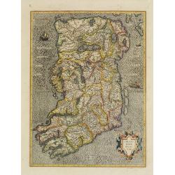
Hiberniae Britannicae insulae nova descriptio.
Copied from Mercator's influential wall map of the British Isles of 1564, this is certainly the best map of Ireland of the 16th century.
Date: Antwerp, 1598
Selling price: ????
Please login to see price!
Sold in 2009
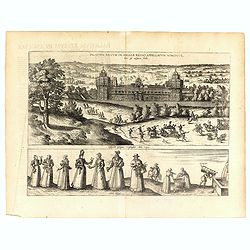
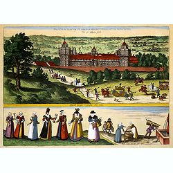
Palatium Regium in Angli├” Regno Appelatum Nonciutz. . .
This engraving is a view of Nonsuch Palace, with carriages and deer hunting, a panel of female costume figures below. Latin text verso, dated in the plate 1582. The scene...
Date: Cologne, 1598
Selling price: ????
Please login to see price!
Sold in 2016
Hiberniae Britannicae insulae nova descriptio.
Copied from Mercator's influential wall map of the British Isles of 1564, this is certainly the best map of Ireland of the 16th century.Dare to go in Black. All early map...
Date: Antwerp, 1598
Selling price: ????
Please login to see price!
Sold in 2018
Cambriae Typus.
Ancient map of Wales, prepared by Humphrey Lhuyd. With fine cartouche, part of a compass-rose and a sea monster.Dare to go in Black. All early maps are printed in black a...
Date: Antwerp, 1598
Selling price: ????
Please login to see price!
Sold in 2018
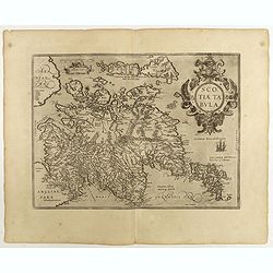
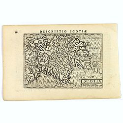
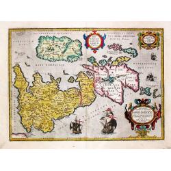
Scotiae tabula.
Fine general map of Scotland with north to right of page. Derived from Mercator's 1564 map of the British Isles in 8 sheets.Dare to go in Black. All early maps are printe...
Date: Anwerp, 1598
Selling price: ????
Please login to see price!
Sold in 2018
Palatium Regium in Angli├” Regno Appelatum Nonciutz. . .
This fine engraving is a view of Nonsuch Palace, with carriages and deer hunting, a panel of female costume figures below. Latin text verso, dated in the plate 1582. The ...
Date: Cologne, 1598
Selling price: ????
Please login to see price!
Sold in 2019
Cantuarbury.
A beautifully rendered and decorative bird's-eye view of the famous English town of Canterbury. The plan identifies important sites and contains four coats-of-arms along ...
Date: Cologne, 1599
Selling price: ????
Please login to see price!
Sold in 2017
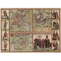
Yorke - Shrowesbury - Lancaster - Richmont.
Four city plans by Braun & Hogenberg on one sheet : Plans of York, Shrewsbury and Lancashire and a view of the castle of Richmond.On each side of the four views are ...
Date: Cologne, 1599
Selling price: ????
Please login to see price!
Sold in 2017
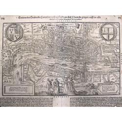
Londen oder Lunden (Londinum Feracis: Ang. Met.).
Superb bird's-eye view of London based on the Braun & Hogenberg view. Shows the area between Clerkenwell, Wapping, Southwark and Westminster Abbey. Elizabethan costum...
Date: Basle, c1600
Selling price: ????
Please login to see price!
Sold in 2013
![Anglia, Regnum si quod aliud in toto Oceano ditissimuin et florentissimum. [imprints] Christophorus Saxton describedat, J.le Clerc ex.](/uploads/cache/28412-250x250.jpg)
Anglia, Regnum si quod aliud in toto Oceano ditissimuin et florentissimum. [imprints] Christophorus Saxton describedat, J.le Clerc ex.
Rare map of England, with elaborate title cartouche, and Royal coat-of-arms A close copy of the Saxton (c.1543-1610) / Ortelius map of 1603, however slightly smaller. Acc...
Date: Paris, 1602
Selling price: ????
Please login to see price!
Sold in 2009
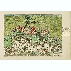
Die Stat und Vestung Kynsael.. Ihrlandt welchs vbr die dreissig Jahr der Cron England zu wider war. . .
Showing siege of Kinsale on 8 January 1602, when the Spanish forces surrender to the English. The Battle of Kinsale was a decisive turning point in Irish history, bringin...
Date: Cologne, 1602
Selling price: ????
Please login to see price!
Sold in 2012
Anglia Regnum si quod aliud in toto Oceano ditissimum et florentissimum.
Rare England map by Ortelius. Latin text on verso.
Date: Antwerp, 1603
Selling price: ????
Please login to see price!
Sold in 2009
Anglia.
Miniature map of England and Wales from Ortelius-Coignet atlas published by Hulsius in Frankfurt after Abraham Ortelius. The title is contained in a strapwork cartouche.I...
Date: Frankfurt, 1604
Selling price: ????
Please login to see price!
Sold in 2014
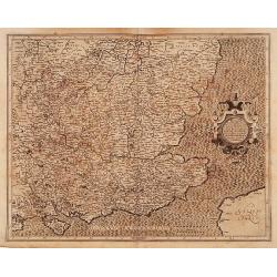
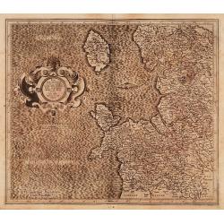
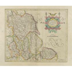
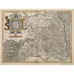
Warwicum Northamtonia Huntingdonia Cantabrigia..
A map of the south-eastern part of England.Mercator was born in Rupelmonde in Flanders and studied in Louvain under Gemma Frisius, Dutch writer, astronomer and mathematic...
Date: Amsterdam 1606
Selling price: ????
Please login to see price!
Sold
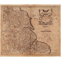
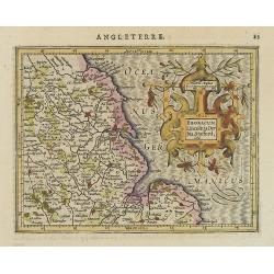
Eboracum, Lincolnia, Derbia, Staffordia, Notinghamia..
Map of the eastern part of England from about Middlesbrough to Yarmouth, inland to include Coventry, Nottingham, Sheffield, Leeds, and York.Mercator was born in Rupelmond...
Date: Amsterdam 1606
Selling price: ????
Please login to see price!
Sold
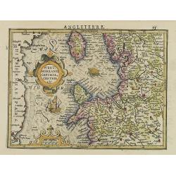
West Morlandia, Lancastria..
A map of the north-western part of England, including the Island of Man.Mercator was born in Rupelmonde in Flanders and studied in Louvain under Gemma Frisius, Dutch writ...
Date: Amsterdam 1606
Selling price: ????
Please login to see price!
Sold
Northumbria, Cumberlandia et Dunelmensis Episcopatus.
A map of the most northern part of England.Mercator was born in Rupelmonde in Flanders and studied in Louvain under Gemma Frisius, Dutch writer, astronomer and mathematic...
Date: Amsterdam 1606
Selling price: ????
Please login to see price!
Sold in 2015
Anglia regnum.
Counties are shown in outline and named. The coast of Ireland is shown across the Irish Sea.Mercator was born in Rupelmonde in Flanders and studied in Louvain under Gemma...
Date: Amsterdam 1606
Selling price: ????
Please login to see price!
Sold
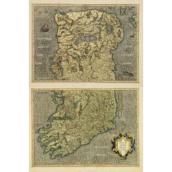
Irlandiae Regnum.
Two fine and early separate maps of southern and northern part of Ireland, can be joined.Mercator was born in Rupelmonde in Flanders and studied in Louvain under Gemma Fr...
Date: Amsterdam 1606
Selling price: ????
Please login to see price!
Sold
Anglia regnum.
Counties are shown in outline and named. The coast of Ireland is shown across the Irish Sea.Mercator was born in Rupelmonde in Flanders and studied in Louvain under Gemma...
Date: Amsterdam 1606
Selling price: ????
Please login to see price!
Sold
Eboracum, Lincolnia, Derbia, Staffordia, etc.
Map of the eastern part of England from about Middlesbrough to Yarmouth, inland to include Coventry, Nottingham, Sheffield, Leeds, and York.Mercator was born in Rupelmond...
Date: Amsterdam, 1606
Selling price: ????
Please login to see price!
Sold
Anglia Regnum.
A map of England from the Mercator's Atlas III. 1606 latin edition.A finely engraved map of Elizabethan England filled with names taken from the Saxton map of 1579. Merca...
Date: Amsterdam, 1606
Selling price: ????
Please login to see price!
Sold in 2015
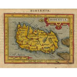
Hibernia.
An attractive miniature map of the island of Ireland, published by Petrus Bertius, in Amsterdam at the beginning of the seventeenth century.Ireland is seen 'lying on its ...
Date: Amsterdam, 1606
Selling price: ????
Please login to see price!
Sold in 2019
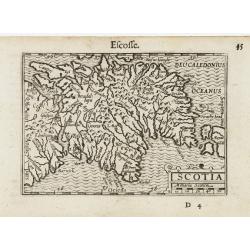
Scotia.
An attractive miniature map of Scotland, published by Petrus Bertius, in Amsterdam at the beginning of the seventeenth century.Scotland is seen 'lying on its back' , as n...
Date: Amsterdam, 1606
Selling price: ????
Please login to see price!
Sold in 2020
Anglia.
An attractive miniature map of Anglia (England & Wales), published by Petrus Bertius, in Amsterdam at the beginning of the seventeenth century.Anglia is seen 'lying o...
Date: Amsterdam, 1606
Selling price: ????
Please login to see price!
Sold in 2020
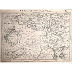
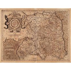
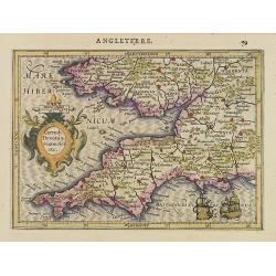
Cornub Devonia Somerset etc. ANGLIAE IIII TABULA.
Mercators map of Southwest England and South Wales. Decorated with a small strapwork title cartouche ŌĆśCornub. Devonia. Somerset etc.ŌĆÖFrom the Latin text edition of Jo...
Date: Amsterdam, 1607
Selling price: ????
Please login to see price!
Sold in 2014
![[Pict warrior holding a head].](/uploads/cache/39409-250x250.jpg)
[Pict warrior holding a head].
A marvellous print by de Bry of a Pict (Celtic / Scottish) warrior holding the head (dripping blood) of a defeated opponent. His nude body is stained and painted, much li...
Date: Frankfurt, 1607
Selling price: ????
Please login to see price!
Sold in 2017
![[An accurate picture of a male neighbour of a Pict].](/uploads/cache/39417-250x250.jpg)
[An accurate picture of a male neighbour of a Pict].
The male neighbours of the Picts wore cloth cassocks or jerkins. They grew their hair and moustaches long but shaved their chins. Around their waists they had girdles fro...
Date: Frankfurt, 1607
Selling price: ????
Please login to see price!
Sold in 2017
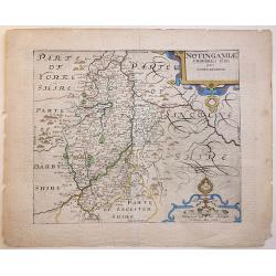
NOTINGAMIAE Comitatus olim pars Coritanorum.
1607 first edition Latin text verso. A very attractive and detailed early 17th Century map of Nottinghamshire - based on the first survey of England by Christopher Saxton...
Date: London, 1607
Selling price: ????
Please login to see price!
Sold in 2020
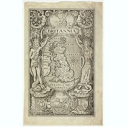
(Title page) Britannia.
Very attractive and decorative early 17th century frontispiece from Camden's Britannia.Below the title, a map of Britain, inscribed with the Latin names places and tribes...
Date: London, W.Hole, ca. 1607
Selling price: ????
Please login to see price!
Sold in 2017
(Irlandiae Regnum - Northern part of Ireland)
Expertly engraved map of Ireland, being the top sheet of Mercator's two-sheet map of Ireland, including sailing ships and a sea monster. From an early edition of Mercator...
Date: Amsterdam, 1607-1608
Selling price: ????
Please login to see price!
Sold in 2020
Scotia.
Map of the Scotland from the first French-text edition of Jodocus Hondius'' Atlas Minor.Shortly after the publication of the big folio-atlases the need was apparently fel...
Date: Amsterdam, 1608
Selling price: ????
Please login to see price!
Sold in 2008
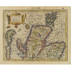
Scotiae Tabula. III.
Map depicting the northern part of Scotland. From the first French-text edition of Jodocus Hondius'' Atlas Minor.Shortly after the publication of the big folio-atlases th...
Date: Amsterdam, 1608
Selling price: ????
Please login to see price!
Sold in 2008
Eboracum Lincolnia Derbia, Stafford, etc.
Charming map of eastern England with a strap work title cartouche. From the first French-text edition of Jodocus Hondius'' Atlas Minor.Shortly after the publication of th...
Date: Amsterdam, 1608
Selling price: ????
Please login to see price!
Sold in 2009
West:morland, Castria, Cestria etc.
Showing the north-western part of England, including the Island of Man, Liverpool, Blackpool, etc.From the first French-text edition of Jodocus Hondius'' Atlas Minor.Shor...
Date: Amsterdam, 1608
Selling price: ????
Please login to see price!
Sold in 2020
Cornub. Devonia, Somerset etc.
Nice map Southwest England and South Wales. Decorated with a small strapwork title cartouche.From the first French-text edition of Jodocus Hondius'' Atlas Minor.Shortly a...
Date: Amsterdam, 1608
Selling price: ????
Please login to see price!
Sold in 2012
Irlandia.
Map of the Ireland from the first French-text edition of Jodocus Hondius' Atlas Minor. Oriented with West on top.Shortly after the publication of the big folio-atlases th...
Date: Amsterdam, 1608
Selling price: ????
Please login to see price!
Sold in 2018
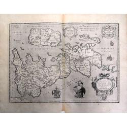
Ultonia Conatia et Media.
Map of Northern Ireland from the first French-text edition of Jodocus Hondius' Atlas Minor.Shortly after the publication of the big folio-atlases the need was apparently ...
Date: Amsterdam, 1608
Selling price: ????
Please login to see price!
Sold in 2017
![[Londinum/Londres]](/uploads/cache/90606-250x250.jpg)
[Londinum/Londres]
Nice rare woodcut view of London on a full text sheet. From \"Parvum Theatrum Urbium sive Urbium Praecipuarum totius orbis Brevis & Methodica Descriptio\" b...
Date: Frankfurt, 1608
Selling price: ????
Please login to see price!
Sold in 2008
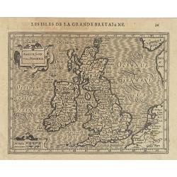
Anglia Sco:tia et Hibernia.
Map of the British Isles from the first French-text edition of Jodocus Hondius' Atlas Minor.Shortly after the publication of the big folio-atlases the need was apparently...
Date: Amsterdam, 1608
Selling price: ????
Please login to see price!
Sold in 2016
Britannicarum Insularum Typus.
Decorative and rare map of the British Isles in Roman times. Based on information from Mercator's 1564 map of the British Isles, improved by a new outline from Saxton's 1...
Date: Antwerp, ca. 1608
Selling price: ????
Please login to see price!
Sold in 2016
Hiberniae Britanicae Insulae Nova Descriptio Eryn Irlandt.
Published in Cologne by J. Bussemacher from 'Geographisch Handtbuch' based upon Mercator's map of the British Isles from 1564.Matthias Quad (1557-1613), was a map publish...
Date: Cologne, 1608
Selling price: ????
Please login to see price!
Sold in 2018
Angliae et Hiberniae.
A rare early map of England and Ireland (and part of Scotland) in perfect condition. Full title in a small cartouche middle top: 'ANGLIAE ET HIBERNIAE | ACCVRATA DESCRIPT...
Date: Antwerp, 1608
Selling price: ????
Please login to see price!
Sold in 2020
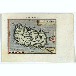
Hibernia.
Miniature map of Ireland with major cities named. North is oriented to the right of the map. Sea is stipple engraved. Strapwork title cartouche at upper right. Latin text...
Date: Antwerp 1609
Selling price: ????
Please login to see price!
Sold
Scotia.
A miniature map of Scotland. Fine cartouche.First published in 1598 in his Caert-Thresoor, the plates were executed by the most famous engravers in Amsterdam, including P...
Date: Amsterdam/Frankfurt 1609
Selling price: ????
Please login to see price!
Sold
Hibernia.
Miniature map of Ireland with major cities named. North is oriented to the right of the map. Sea is stipple engraved. Strap work title cartouche at upper right. Latin tex...
Date: Antwerp, 1609
Selling price: ????
Please login to see price!
Sold in 2017
Angliae et Hiberniae Accurata Decriptio. . .
One of the most decorative and rare maps of Great Britain and Ireland by Jan Baptist Vrients (1552-1612) in original color. The map first appeared in 1606, and this is st...
Date: Antwerp, 1609
Selling price: ????
Please login to see price!
Sold in 2020
Brittanicarum Insularum Typus. 1595.
A map of Roman Britain based on information from Mercator's 1564 map of the British Isles, improved by a new outline from Saxton's 1579 map, and ancient knowledge from Di...
Date: Antwerp, 1609
Selling price: ????
Please login to see price!
Sold in 2021
Irlandiae regnum.
One of the earliest maps of Ireland.
Date: Amsterdam 1610
Selling price: ????
Please login to see price!
Sold
Northumbria, cum Berlandia, et Dunelmensis Episcopatus.
A lovely early map of border region between England and Scotland. The seas are engraved in Mercator's characteristic wave pattern and the interior is filled with detail. ...
Date: Amsterdam, 1610
Selling price: ????
Please login to see price!
Sold in 2010
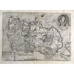
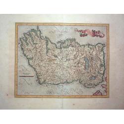
Hiberniae Ireland Anglis Yuerdon Britannis Erin incolis Ierna Orpheo & Arist. Iris Diodoro Siculo Juverna Juvenali Joyernia Ptol.Christopher Saxton & William Hole
One of the earliest obtainable maps of Ireland. Oriented with West at the top. Highly detailed.This map of Ireland is derived from Baptista Boazio's map of Ireland dating...
Date: London, 1610
Selling price: ????
Please login to see price!
Sold in 2013
Stonehenge.
Stonehenge from 1610 edition of CamdenŌĆÖs Britannia. Attributed to William Kip One of the most important engravings in the 1610 edition is this splendid one of Stoneheng...
Date: London, 1610
Selling price: ????
Please login to see price!
Sold in 2012
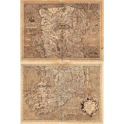
Irlandiae regnum. (2-sheets)
A early and large scale, two-sheet map of Ireland, which can be joined.The maps are richly engraved with a moir├® pattern in the seas and strong topographical features in...
Date: Amsterdam, 1610
Selling price: ????
Please login to see price!
Sold in 2016
Irlandiae Regnum.
Gerard Mercator's map of Ireland from the Mercator Hondius atlas with Latin text printed on the back. A fine, early map of Ireland with west at the top of the map. This i...
Date: Duisberg, Amsterdam, 1587-1610
Selling price: ????
Please login to see price!
Sold in 2015
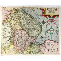
Lincolniae Comitatus Ubi Olim Insederunt Coritani.
A fine copper engraved map by William Kip, after Christopher Saxton. A map of Lincolnshire from the second edition of Philemon HollandŌĆÖs translation of CamdenŌĆÖs Brit...
Date: London, 1610
Selling price: ????
Please login to see price!
Sold in 2016
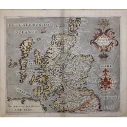
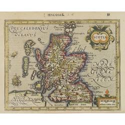
SCOTIA REGNUM
Second state map of Scotland 'SCOTIA REGNUM' By William Hole based on Christopher SaxtonŌĆÖs map of 1579, signed in the plate.A very attractive and decorative early 17th ...
Date: London, 1610
Selling price: ????
Please login to see price!
Sold in 2016
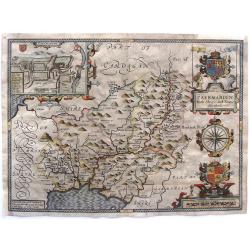
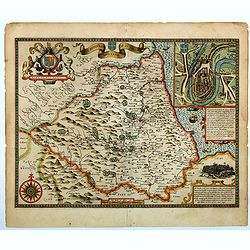
Caermarden, Both Shyre And Towne Described.
This is probably the most decorative map of Caermarden county. It has an inset plan of Caermarthen, two cartouches with armorials, wonderful compass rose and the Prince ...
Date: London, 1610
Selling price: ????
Please login to see price!
Sold in 2017
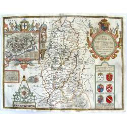
The Countie of Nottingham described. The Shire Townes Situation and the Earls there of observed.
From Speed's atlas, engraved by Jodocus Hondius. With inset plan of Nottingham. Huge, beautiful cartouche featuring putti with bow & arrows, pheasants, crown and co...
Date: London, Thomas Bassett and Richard Chiswell, 1610
Selling price: ????
Please login to see price!
Sold in 2015
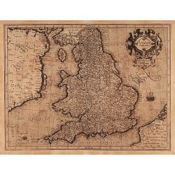
The Kingdome of England
The most famous and iconic map of England in the Stuart period. Rare first state of the map. Handsome copper engraved map from Speed's "Theatre of the Empire of Grea...
Date: London, 1610
Selling price: ????
Please login to see price!
Sold in 2015
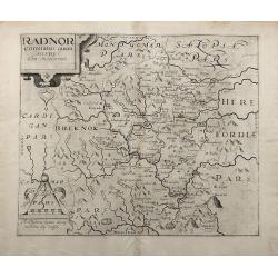
Radnor Comitatus quem Silvres.
A decorative map of the Welsh county of Radnorshire, in Mid-Wales, engraved by William Kip, after Christopher Saxton, for the second English edition of Camden's 'Britanni...
Date: London, 1610
Selling price: ????
Please login to see price!
Sold in 2017
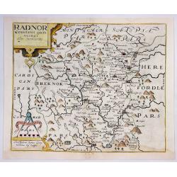
Radnor Comitatus Quem Silvres.
A decorative map of the Welsh county of Radnorshire, in Mid-Wales, engraved by William Kip, after Christopher Saxton, for the second English edition of Camden's 'Britanni...
Date: London, 1610
Selling price: ????
Please login to see price!
Sold in 2018
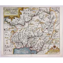
Caermardt Comitatus in Quo Dimetae.
A decorative map of the Welsh county of Caermarthen, in Wales, engraved by William Kip, after Christopher Saxton, for the second English edition of Camden's 'Britannia', ...
Date: London, 1610
Selling price: ????
Please login to see price!
Sold in 2017
Merionethshire, Described 1610.
A beautiful Welsh county map of Merionethshire; part of the renowned ŌĆ£Theatre of the Empire of Great BritaineŌĆØ by English cartographer John Speed. The copper plates w...
Date: London, 1610
Selling price: ????
Please login to see price!
Sold in 2020
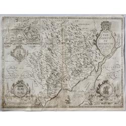
The Countye of Monmouth. . .
A beautiful Welsh county map of Monmouth Shire; part of the renowned ŌĆ£Theatre of the Empire of Great BritaineŌĆØ by English cartographer John Speed. The copper plates w...
Date: London, ca. 1610
Selling price: ????
Please login to see price!
Sold in 2019
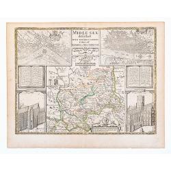
Middlesex. Midle-sex described With The Most Famous Cities Of London and Westminster.
Old outline color to map of the county delineating the hundreds. Double page. A wonderfully decorative map of Middlesex incorporating maps of London and Westminster to up...
Date: London, Thomas Basset and Richard Chiswell. 1610
Selling price: ????
Please login to see price!
Sold in 2020
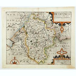
Bedford Comitatus olim pars Cathifuclanorum.
A beautiful early 17th century map of Befordshire, based on the first survey of England by Christopher Saxton, and published in Camden's Britannia (pub. London: 1607-1637...
Date: London, 1610
Selling price: ????
Please login to see price!
Sold in 2021
![[Berkshire]. Bercheriae vulgo Barkshyre qui olim sedes A:Trebatum.](/uploads/cache/1156346-250x250.jpg)
[Berkshire]. Bercheriae vulgo Barkshyre qui olim sedes A:Trebatum.
Original uncoloured engraved map of Berkshire trimmed to neatline and backed onto 18th century laid paper. Map dimensions 23 x 32 cm, overall backing-sheet size 32 x 40 c...
Date: London: Impensis Georgii Bishop & Ioannis Norton, 1610
Selling price: ????
Please login to see price!
Sold in 2023
The Bishoprick and Citie of Durham.
A beautiful first edition John Speed map of Co. Durham.Aesthetically, it is considered one of the most accomplished maps in the 'Theatre', noted for its clarity and featu...
Date: London, 1611
Selling price: ????
Please login to see price!
Sold in 2023
-250x250.JPG)
Kent with her Cities and Earls Described and Observed
A rare highly decorative and finely engraved early 17th-century map of Kent was published in John Speed's Theatre of the Empire of Great Britaine. The inset plans of Cant...
Date: London, 1611
Selling price: ????
Please login to see price!
Sold in 2022
Angliae et Hiberniae Accurata descriptio.
Rare Johann Baptist Vrients map of England and Wales including a genealogical tree from William the Conqueror to the time of publication and James I. The map first appear...
Date: Antwerp, 1612
Selling price: ????
Please login to see price!
Sold in 2009
