Sign In or Sign Up
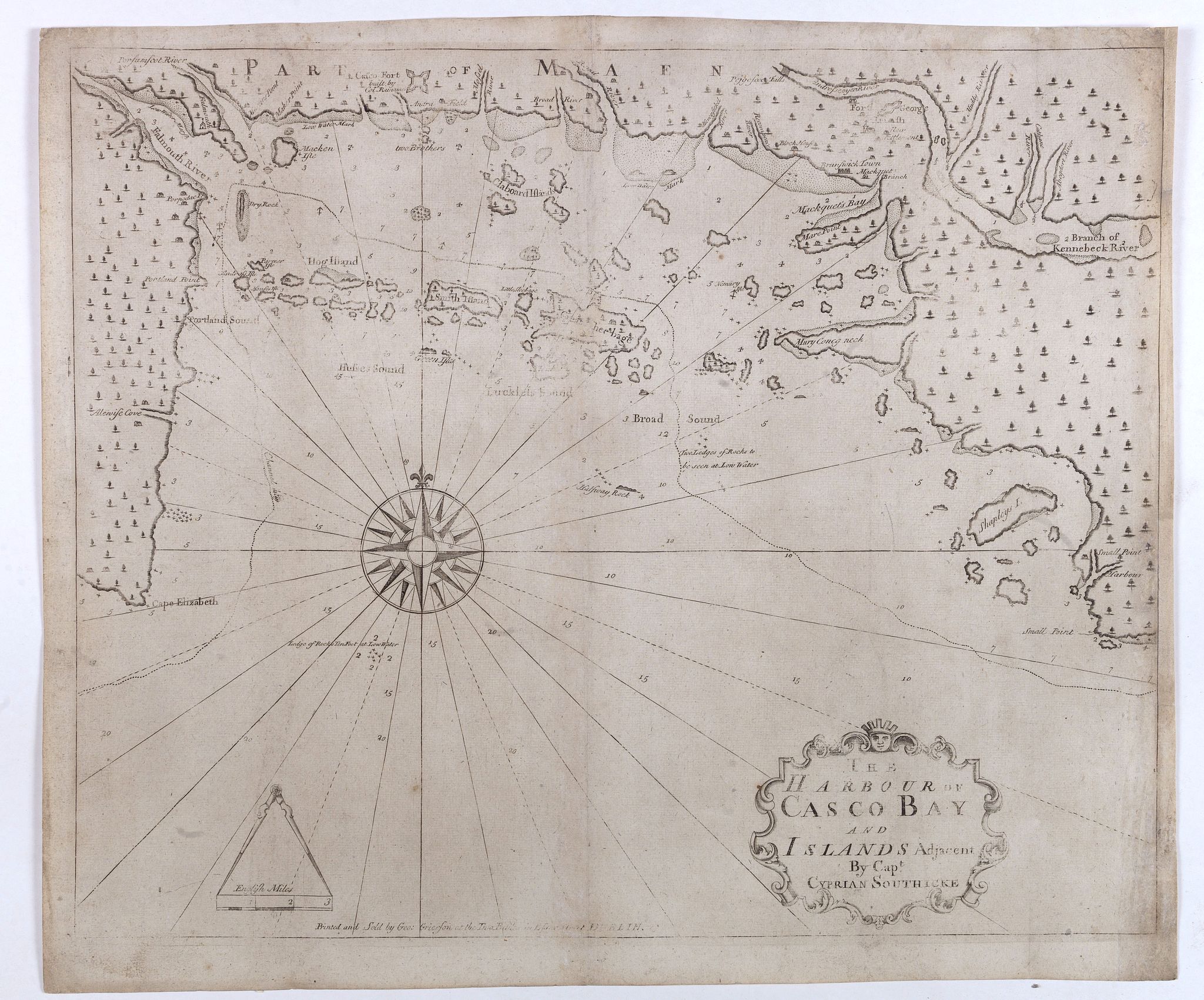
The Harbour of Casco Bay and Islands Adjacent Bt Capt. Cyprian Southicke. |
||||||||||||||||||||
|
||||||||||||||||||||
|
|
||||||||||||||||||||
$2500 / ≈ €2197This item is available for immediate sale! Questions before Buying ?
We are happy to answer your questions. |
My Collection +
Add this or any of your favorite items in one place. If you want to save the items permanently, you have to sign in or create an account first. |
|||||||||||||||||||
Description
The earliest printed chart of Casco Bay, an inlet of the Gulf of Maine on the southern coast of Maine, New England.
First issued in 1720 by Mount and Page, it remained in print for decades and was not superseded for more than half a century, here from the very rare Dublin pirated edition.
Grierson published only one edition of the pirated "The Fourth book of the English Pilot" in 1749. This is the second issue of the chart by Boulter Grierson published in 1767 and has no watermark, an edition almost as rare as the first. The charts are from the same plates without change, even to the imprints.
After his death in 1753 his eldest son, George Abraham Grierson, continued the business, but for only two years.
Upon the death of this son in 1755, his executors carried on until 1758, at which time a second son, Boulter, acquired possession.
Boulter Gierson was the son of George's second wife, a sister to the noted printer James Blow of Belfast.
Cyprian Southack was born in London in 1662 and emigrated to Boston in 1685. For many years English settlers in coastal Maine were targets for attack by the French-backed Abenaki and other indigenous groups. Southack consequently made many trips to Casco Bay, including one in 1702, when as captain of the Province Galley he raised a siege of Fort Casco.
FAQ - Guarantee - Shipping
Buying in the BuyNow Gallery
This item is available for immediate purchase when a "Add to Cart" or "Inquire Now" button is shown.
Items are sold in the EU margin scheme
Payments are accepted in Euros or US Dollars.
Authenticity Guarantee
 We provide professional descriptions, condition report (based on 45 years experience in the map business)
Paulus Swaen warrants the authenticity of our items and a certificate of authenticity is provided for each acquired lot.
Condition and Coloring
We indicate the condition of each item and use our unnique HiBCoR grading system in which four key items determine a map's value: Historical Importance, Beauty, Condition/Coloring and Rarity.
Color Key
We offer many maps in their original black and white condition. We do not systematically color-up maps to make them more sellable to the general public or buyer.
Copper engraved or wood block maps are always hand colored. Maps were initially colored for aesthetic reasons and to improve readability. Nowadays, it is becoming a challenge to find maps in their original colors and are therefor more valuable.
We use the following color keys in our catalog:
Original colors; mean that the colors have been applied around the time the map was issued.
Original o/l colors; means the map has only the borders colored at the time of publication.
Colored; If the colors are applied recently or at the end of the 20th century.
Read more about coloring of maps [+]
Shipping fee
A flat shipping fee of $ 30 is added to each shipment by DHL within Europe and North America. This covers : International Priority shipping, Packing and Insurance (up to the invoice amount).
Shipments to Asia are $ 40 and rest of the world $50
We charge only one shipping fee when you have been successful on multiple items or when you want to combine gallery and auction purchases.
Read more about invoicing and shipping
FAQ
Please have a look for more information about buying in the BuyNow gallery
Many answers are likely to find in the general help section.
My Collection+
![]()
With My Collection+ you can collect all your favorite items in one place. It is free, and anyone can create his or her virtual collection.
Unless you are logged in, the item is only saved for this session. You have to be registed and logged-in if you want to save this item permanently to My Collection+.
Read More[+]
Register here, it is free and you do not need a credit card.
Add this item to
My Collection+
or click the following link to see My Collection+.
| Digital Image Download | |
|
Paulus Swaen maintains an archive of most of our high-resolution rare maps, prints, posters and medieval manuscript scans. We make them freely available for download and study. Read more about free image download |
Click the image for a free small image download. |
In accordance with the EU Consumer Rights Directive and habitually reside in the European Union you have the right to cancel the contract for the purchase of a lot, without giving any reason.
The cancellation period will expire 14 calendar days from the day after the date on which you or a third party (other than the carrier and indicated by you) acquires, physical possession of the lot. To exercise the right to cancel you must inform Paulus Swaen Inc, of your decision to cancel this contract by a clear statement (e.g. a letter sent by post, or e-mail.
To meet the cancellation deadline, it is sufficient for you to send your communication concerning your exercise of the right to cancel before the cancellation period has expired.
Recently Viewed

The Harbour of Casco Bay and Islands Adjacent Bt Capt. Cyprian Southicke.
The earliest printed chart of Casco Bay, an inlet of the Gulf of Maine on the southern coast of Maine, New England. First issued in 1720 by Mount and Page, it remained in...
Date: Dublin, 1767
Air France - Corse.
Corsica poster for Air France, by Raoul Éric Castel (1915 - 1997) and published by Havas. Signed has work with Éric, he was born in Lyon and made many fine travel posters...
Date: Imprimerie Perceval Paris, ca. 1940-1950
