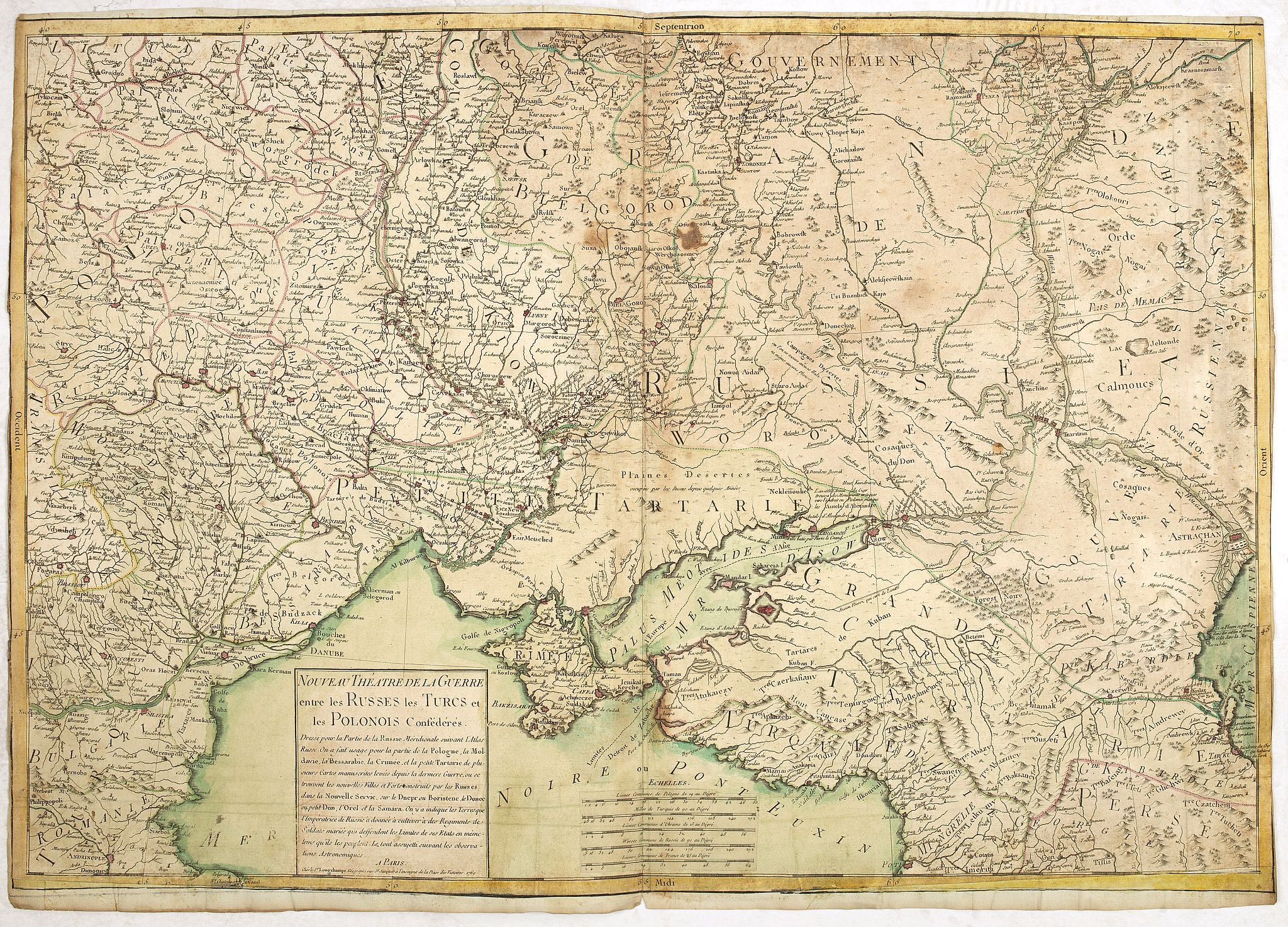
1769 LONGCHAMPS, le Sieur. - A very rare separately published map of the Crimea region, showing the situation in 1769 during the Russo-Turkish War of 1768–1774.
Nouveau théâtre de la guerre entre les Russes les turcs et les polonois confédérés. |
||||||||||||||||||||
|
||||||||||||||||||||
|
|
||||||||||||||||||||
$1500 / ≈ €1334This item is available for immediate sale! Questions before Buying ?
We are happy to answer your questions. |
My Collection +
Add this or any of your favorite items in one place. If you want to save the items permanently, you have to sign in or create an account first.   Add/Remove
Watchers:
4
|
|||||||||||||||||||



Description
A very rare, separately published, historically important war map documenting Russia’s southward expansion, the Russo-Turkish conflict, Crimea, Ukraine, and the Black Sea region at a decisive moment in eighteenth-century European history. The map was compiled from the Russian Atlas, together with manuscript surveys made after the preceding wars, and incorporates recently constructed Russian towns and forts along the Dnieper, Donets, Orel, and Samara rivers. It also identifies lands granted by the Russian Empress for settlement by married military regiments, intended both to cultivate the frontier and to defend the expanding southern limits of the Russian Empire.
Of particular historical interest is the map’s depiction of the geopolitical situation in 1769, when Russia, the Ottoman Empire and the Polish Confederates were engaged in a conflict that would transform the balance of power around the Black Sea. Crimea and the territories of the Crimean Tatars occupy a central position, while Poland, Moldavia, Bessarabia and the northern Black Sea littoral are shown in considerable detail.With a large title cartouche lower left "Nouveau theâtre de la guerre entre les russes, les turcs et les polonois confédérés, dressé pour la partie de la Russie méridionale suivant l'Atlas russe, on a fait usage pour la partie de la Pologne, la Moldavie, la Bessarabie, la Crimée et la Petite Tartarie de plusieurs cartes manuscrites levées depuis la dernière guerre, où se trouvent les nouvelles villes et forts construits par les russes dans la nouvelle Servie, sur le Dnepr ou Boristène, le Donec ou petit Don, l'Orel et la Samara, on y a indiqué les terres que l'impératrice de Russie a donnée à cultiver à des régiments de soldats mariés qui deffendent les limites de ses états en même tems qu'ils les peuplent, le tout assujetti suivant les observations astronomiques."
Interesting map showing the situation in 1769 during the Russo-Turkish War of 1768–1774.
The Russo-Turkish War continued Russia’s struggle for an outlet on the Black Sea and against Ottoman aggression, as the Ottomans tried to expand their possessions along the Black Sea and in the Caucasus and seize Astrakhan. Turkey also opposed the growth of Russian influence in Poland, where the Russian protégé, Stanislaw August Poniatowski, became king in 1764.
The immediate cause of the war was Russia’s rejection of a Turkish ultimatum calling for the withdrawal of Russian forces from Poland, where, in 1768, they began military operations against the Confederation of Bar. Subsequently, on Sept. 25 (Oct. 6), 1768, Turkey, supported by France and Austria, declared war on Russia.
The Russian strategic plan for 1769 provided for an offensive against Khotin by the main forces and General A. M. Goli-tsyn’s First Army (80,000–90,000 men). General P. A. Rumiant-sev’s Second Army (35,000 men) supported the main forces by covering the southern boundaries from the Dnieper to the Don against the Crimean Tatars.
The Baltic Fleet was sent to the Mediterranean Sea to blockade the Dardanelles and support the national liberation movement in Greece. In early 1769, the Second Army repulsed a Crimean Tatar incursion and reached the shore of the Sea of Azov.
Although two assaults on Khotin by the First Army in April and June were unsuccessful, the Turkish garrison abandoned the town in September because of a shortage of provisions.
Read more about maps of Ukraine [+]
Read more about maps of Ukraine [+]
FAQ - Guarantee - Shipping
This item is available for immediate purchase when a "Add to Cart" or "Inquire Now" button is shown.
Items are sold in the EU margin scheme
Payments are accepted in Euros or US Dollars.
Authenticity Guarantee
 We provide professional descriptions, condition report (based on 45 years experience in the map business)
Paulus Swaen warrants the authenticity of our items and a certificate of authenticity is provided for each acquired lot.
Condition and Coloring
We indicate the condition of each item and use our unnique HiBCoR grading system in which four key items determine a map's value: Historical Importance, Beauty, Condition/Coloring and Rarity.
Color Key
We offer many maps in their original black and white condition. We do not systematically color-up maps to make them more sellable to the general public or buyer.
Copper engraved or wood block maps are always hand colored. Maps were initially colored for aesthetic reasons and to improve readability. Nowadays, it is becoming a challenge to find maps in their original colors and are therefor more valuable.
We use the following color keys in our catalog:
Original colors; mean that the colors have been applied around the time the map was issued.
Original o/l colors; means the map has only the borders colored at the time of publication.
Colored; If the colors are applied recently or at the end of the 20th century.
Read more about coloring of maps [+]
Shipping fee
A flat shipping fee of $ 30 is added to each shipment by DHL within Europe and North America. This covers : International Priority shipping, Packing and Insurance (up to the invoice amount).
Shipments to Asia are $ 40 and rest of the world $50
We charge only one shipping fee when you have been successful on multiple items or when you want to combine gallery and auction purchases.
Read more about invoicing and shipping
FAQ
Please have a look for more information about buying in the BuyNow gallery
Many answers are likely to find in the general help section.
My Collection+

With My Collection+ you can collect all your favorite items in one place. It is free, and anyone can create his or her virtual collection.
Unless you are logged in, the item is only saved for this session. You have to be registed and logged-in if you want to save this item permanently to My Collection+. Read More[+]
Register here, it is free and you do not need a credit card.
Add this item to My Collection+ or click the following link to see My Collection+.
|
Digital Image Download Paulus Swaen maintains an archive of most of our high-resolution rare maps, prints, posters and medieval manuscript scans. We make them freely available for download and study. Read more about free image download |
Click the image for a free small image download. |
YOUR RIGHT TO CANCEL THE PURCHASE OF A LOT
In accordance with the EU Consumer Rights Directive and habitually reside in the European Union you have the right to cancel the contract for the purchase of a lot, without giving any reason.
The cancellation period will expire 14 calendar days from the day after the date on which you or a third party (other than the carrier and indicated by you) acquires, physical possession of the lot. To exercise the right to cancel you must inform Paulus Swaen Inc, of your decision to cancel this contract by a clear statement (e.g. a letter sent by post, or e-mail.
To meet the cancellation deadline, it is sufficient for you to send your communication concerning your exercise of the right to cancel before the cancellation period has expired.
