MÜNSTER - Geographia universalis, vetus et nova, complectens
The rare FIRST EDITION of Sebastian Münster’s Geographia Universalis, published in 1540. This was a new and important
edition of Ptolemy, with redesigned maps
and the text revised by Münster based on the Willibald Pirckheimer Latin translation with corrections of 1535 by Servetus.
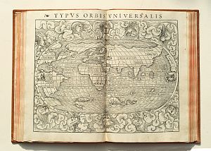
The Geographia was a landmark work that contained, along with the Ptolemaic maps, several of the most significant modern maps in the history of cartography.
With 27 maps of the ancient world and 21 of the modern world, together 48 double-page woodcut maps, each within a woodcut border, 7 woodcut diagrams in the text and one full-page woodcut, printer’s woodcut device on verso of colophon leaf, woodcut initials throughout.
sold
The first separate maps of the four continents appear here. They include the earliest maps of Africa, also the first separately printed map of England, and the oldest obtainable woodcut of Scandinavia.
The map Novarum insularum is one of
the earliest available separate maps depicting the Americas in a recognizable form.
Sebastian Münster (1448-1552) was a mathematician, geographer and professor at Basel University. He also compiled a highly influential
encyclopaedic work entitled Cosmographia universalis, which first appeared in 1544 and contained forty-eight woodcut maps. He was among the first editors of a
published geographical text to quote or acknowledge his sources and authorities.
 With 27 maps of the ancient world and 21 of the modern world, together
48 double-page woodcut maps, each within a woodcut border, 7 woodcut diagrams in the text and one full-page woodcut, printer’s woodcut device on verso of colophon
leaf, woodcut initials throughout.
With 27 maps of the ancient world and 21 of the modern world, together
48 double-page woodcut maps, each within a woodcut border, 7 woodcut diagrams in the text and one full-page woodcut, printer’s woodcut device on verso of colophon
leaf, woodcut initials throughout.
Folio, blind-stamped calf binding. Letterpress title (with manuscript marginal exlibris), 3, Liber I -17,6 pp index, 196pp - Liber II,
Letterpress title, 27 maps of the ancient world and 21 of the modern world.
