Guillaume de L'Isle Atlas
 DE L'ISLE - (Atlas). Paris, de l’Isle, 1700 à 1725. In-large folio atlas containing 91 maps in contemporary outline coloring.
Very fine French contemporary binding of blind-stamped full brown calf over pasteboard, spine richly gilted with seven raised bands and red morocco label "ATLAS DE DELISLE", covers decorated with a blind-stamped double frame. Binding is very slightly used, with some minor ancient restorations and generally in very good condition.
DE L'ISLE - (Atlas). Paris, de l’Isle, 1700 à 1725. In-large folio atlas containing 91 maps in contemporary outline coloring.
Very fine French contemporary binding of blind-stamped full brown calf over pasteboard, spine richly gilted with seven raised bands and red morocco label "ATLAS DE DELISLE", covers decorated with a blind-stamped double frame. Binding is very slightly used, with some minor ancient restorations and generally in very good condition.
This is an early edition of DeL'Isle's untitled atlas, published in Paris, with most of the maps having the "Quai de l'Horloge" imprint and printed on heavy paper. The atlas is without a title page, as issued.
The maps of the Britsh Isles (Tooley Delisle 1), Poland, Belgium, Canada, Terre Ferme have the address "Chéz l'Auteur sur le Quai de l'Horloge a L'aigle d'Or".
The atlas contains a World map in double hemispheres. 4 continent maps, 48 maps of European countries, including a fine plan of Paris; Plan de la Ville et Fauxbourgs de Paris. 10 maps of Asia, including 2 charts of the Caspian Sea, 5 maps of Africa, 8 maps of the Americas and Caribbean and 14 maps of the Ancient World. Extra bound in : J.B.HOMANN. Postarum seu veredariorum statimes per Germaniam et provincias adjacentes. Neu-vermetra Post-Charte dusch gantz Teutschland... (Nuremberg, 1709).
Sold
The first 72 maps are numbered in an 18th-century hand, together with an index sheet written in the same hand, calling for the first 72 maps. The extra map by Homann is mentioned on this index list.
The inside is very clean and the maps are printed on thick paper. Only a few maps, mainly in the ancient section, have some light marginal water staining.
The atlas is without a title page, as issued.
DeLisle is important as the first "scientific" cartographer who incorporated the most current information on exploration and topography into his maps. His maps of America contain many innovations:
discarding the fallacy of California as an island, the first naming of Texas, the first correct delineation of the Mississippi Valley, and the first correct longitudes of America. Lloyd Brown states that DeLisle "undertook a complete reform of a system of geography that had been in force since the second century, and by the time he was twenty-five, he had nearly accomplished his purpose."
 Maps relating to the Americas who are present :
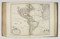
- Mappemonde, 1720;
- Hémisphère occidental, 1st issue 1724;
- Hémisphère septentrional, 1714;
- Hémisphère méridional, 1714;
- Carte d'Amerique, 1st issue, 2nd state 1722 (with America in plain lettering);
 - L'Amerique Meridionale, 3rd issue 1700-1708;
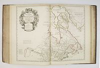
- Carte du Canada, 2nd issue 1703-1708 (The first printed map to show Detroit only two years after the founding of that village by Cadillac. Based on the work of Franquenlin Joliet and the Jesuits. In this map de l'Isle gives a superior rendering of the Great Lakes area.);
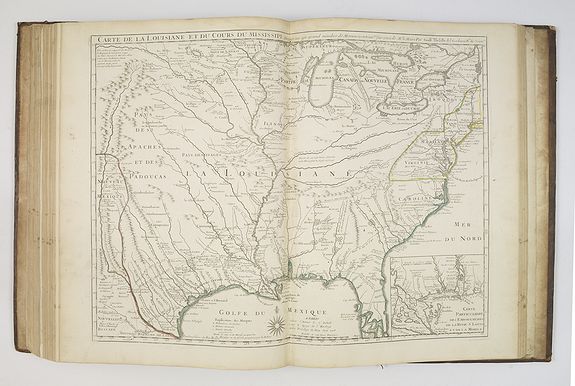
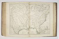 - Carte de la Louisiane, 1st issue, 1st state without New Orleans 1718 (The map contains the first indications of the explorations of De Soto, Cavelier, Tonty, Moscoso and Denis. It included the best depiction of the Mississippi River to date, for the first time presenting a roughly accurate delineation of its entire length, as well as a semblance of accuracy about many of its tributaries. It was also the first map to include the name Texas with the legend "Mission de los Teijas," indicating a Mission established in 1716.)
According to Cohen in Mapping the West : A significant map in Western American History and a work by one of the greatest mapmakers of all time. The map revealed for the first time the importance of the Missouri River. It gave the most accurate delineation of the Mississippi Valley up to that time… [Delisle’s] passion for pure scientific accuracy is reflected on his maps. If a reliable source had not directly observed geographic information, he refused to acknowledge it. Many longstanding myths and errors passed from mapmaker to mapmaker for generations were suddenly absent on Delisle’s maps.;
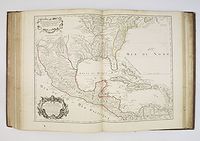 -
Carte du Mexique et de la Floride, 2nd issue 1703-1708; ( the first printed map to accurately depict the course and mouth of the Mississippi River. First edition, third state; The first edition bears De L'Isle's first address on Rue Des Canettes, which was later changed to Quai de l'Horloge Couronne de Diamans and the imprint of Renard in the second state. In the third state, the Couronne de Diamans and Renard imprint are removed and the engraver's name Simoneau appears. )
-
Carte du Mexique et de la Floride, 2nd issue 1703-1708; ( the first printed map to accurately depict the course and mouth of the Mississippi River. First edition, third state; The first edition bears De L'Isle's first address on Rue Des Canettes, which was later changed to Quai de l'Horloge Couronne de Diamans and the imprint of Renard in the second state. In the third state, the Couronne de Diamans and Renard imprint are removed and the engraver's name Simoneau appears. )
- Carte de l'Isle de Saint Dominique, 1st issue 1725;
- Carte des Antilles françoises et des isles voisines, 1st issue 1717;
- Carte de la Terre Ferme du Pérou, du Brazil et du pays des Amazones, 2nd issue 1703-1708; and
- Carte du Paraguay du Chili, du détroit de Magellan,
2nd issue 1703-1708.
The maps of the Asian continent and Carte des Indes et de la Chine. 1705 showing a "Mer Orientale ou Mer de Corée".
According to David Rumsey, Early Paris editions (ie before Buache became publisher in 1732) of DeLisle's atlas with the full 94 maps are scarce - the LOC has none.
Reference: Philips, A list of geographical atlases, 535 (describing a slightly later edition).
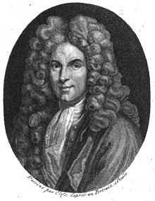
Guillaume De L'Isle was born in 1675 in Paris and by the turn of the century was the most prominent map-maker of the time. Having been taught geography by his father Claude, himself a geographer and historian, Guillaume is reputed to have drawn his first map at the age of nine and was viewed as a child prodigy.
His training in mathematics and astronomy led to a more scientific approach to map-making, with a reliance on verifiable information, in contrast to the earlier Dutch map-makers, who emphasized aesthetic values. This rigorous scientific approach brought recognition, and in 1702, two years after the publication of his first atlas, he was elected a member of the Academie Royale des Sciences, and in 1718, he achieved his greatest honor when he was appointed 'Premier Geographe du Roi'.
When he died in 1726, his business was carried on by his nephew Philippe Buache, whose maps and atlases focused on physical geography and were among the first to attempt to map the undersea world.
