The Civitates Orbis Terrarum (Atlas of Cities of the World) by Braun and Hogenberg
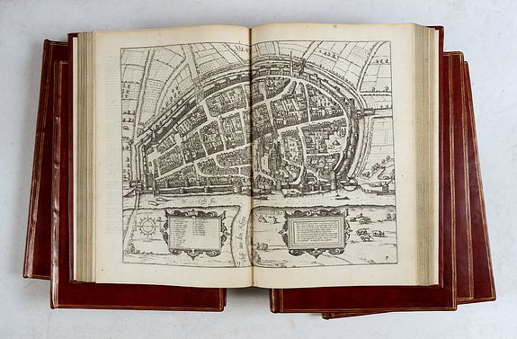
The Civitates Orbis Terrarum (Atlas of Cities of the World) by Hogenberg was the second-oldest printed atlas in the history of world cartography and the first atlas of towns. Its principal creators and authors were the theologian and editor Georg Braun, the most important engraver and publisher Frans Hogenberg, the engraver Simon van den Neuvel, the artist and draftsman Georg (Joris) Hoefnagel, the topographer Jacob van Deventer, and others.
Although published outside the Netherlands, the Civitates is one of the best examples of the Antwerp school of cartography.
Some of the key figures in the school were Abraham Ortelius, Gerardus Mercator, and several other geographers. The Civitates reflects the Flemish engraving style typical of the Dutch atlases of the period. In addition, Braun, Hogenberg,
and Ortelius's correspondence clearly indicates that they conceived the idea of creating the atlas in Antwerp.
The more than 500 maps in the atlas represent an entire era of town mapping. Six volumes of the atlas were published between 1572 and 1617. Braun corresponded extensively with map sellers and scholars from different cities and countries to obtain the originals for his work. In addition, the authors carried out their investigations.
However, these were not genuine geodetic surveys but detailed on-location drawings of panoramic views of the towns made from some high point. Most of the engravings that decorate the Civitates from its first volume to its last were made from drawings by Georg Hoefnagel. Hoefnagel drew images of many towns in France, Italy, England, and Spain.
He and his son Jacob subsequently created representations of Austrian and Hungarian towns for the Civitates. Besides such overview plans, the atlas also includes more detailed maps based on topographic surveys, particularly the surveys of Jacob van Deventer (15??-1575). Correspondingly, the maps show the systematic structure of the towns' buildings, with perspective representations of various quarters and individual buildings.
The town is usually placed in the background, while the foreground depicts the surrounding countryside and the town's typical inhabitants in detail.
These visual representations of people served not only to augment the contents of the maps but also for another purpose. The pages of Braun and Hogenberg's Civitates were illustrated with figures of local inhabitants to prevent the maps from being used by the Turks for military goals since Islam forbids images of humans.
Of the total towns, only a few are located outside Europe: in Asia, Africa, and South America. This is evidence of minimal cartographic knowledge of the world, due to insufficient scientific development and mapmaking practices in the second half of the sixteenth century. At the same time, it is impossible not to be astonished at the huge quantity - by the standards of the time - of material included in the atlas.
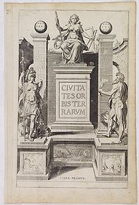 Braun and Hogenberg's Civitates was an enormous success. It was republished and supplemented by new sections many times. Maps contained in it became exemplary; they were frequently reproduced in a smaller format by other publishers as illustrations for books and maps.
After Franz Hogenberg's death, the typographic plates for the atlas remained in Cologne, in the possession of Abraham Hogenberg. When Abraham died in 1653, his heirs sold them to Johannes Janssonius, an active and skilled publisher of books and atlases in Amsterdam. In 1657, Janssonius issued the atlas in eight volumes in a completely revised edition, with illustrations arranged by country. A large number of quite new engravings were added to it, while outdated prints were omitted. Following Janssonius's death in 1664, the engravings became the property of his grandson Johannes Janssonius van Waesberge, who used some of them to compile his own atlas, which appeared in 1682.
In 1694, van Waesberge's copper plates and equipment were purchased at auction by the energetic Amsterdam publisher Frederick de Wit, who was well-known for his numerous maps and atlases. De Wit organized a new edition, which was also enriched with new engravings.
After de Wit's time, at the turn of the eighteenth century, the copper plates for the atlas passed into the hands of the publisher Pieter van der Aa (1659 - 1733). He acquired them in Leyden and used them for an atlas that was published in 1729. This publication included a diverse mixture of engravings from the sixteenth to eighteenth centuries.
After van der Aa, ownership of town maps bearing the publisher's imprint de Wit was transferred to Covens and Mortier's publishing house. The multiple reproductions by various publishers of these 16th-century perspective views and maps over centuries can be explained by their rich historical and geographical content.
At the same time, it is necessary to say that there is no atlas of the world's cities in the history of global cartography to equal the Civitates Orbis Terrarum in its size and fullness.
In addition to its historical, geographical, and cartographic significance, the Civitates is also of great artistic value. That is why, up until now, the town maps contained in the atlas have adorned the most exquisite interiors and attracted the attention of specialists in the field and all admirers of fine art.
The first volume of the Civitates Orbis Terrarum was published in 1572. Ultimately, the publication would consist of six folio parts with a total of 363 plates of 543 town illustrations. Each time a new volume was published, there was a new edition of the previous volumes.
As the cities of Europe (principally; there are views of cities on three additional continents: North America (Mexico and Cuzco, I.58), Africa (Cairo, Tangier, Casablanca; I.55-57) and Asia (Aden, I.53; Calicut, I.54 and Jerusalem several times).
Frans Hogenberg (1535-1590) was one of the greatest engravers of his generation. Not only did he engrave most of the plates for Civitates, but he was also responsible for many of those included in Ortelius's Theatrum. They relied mainly on existing maps and drawings made by the Antwerp artist.
Joris Hoefnagel (1542-1600), who had traveled through most of Western Europe. He provided original drawings of Spanish and Italian towns, as well as reworked and improved drawings of other artists' towns. After Joris's death, his son Jakob continued the project.
The Civitates Orbis Terrarum includes in total the work of over 100 artists and topographers.
A German text edition.
- Part I : 1574 (1582). Engraved title-page with German title pasted-on label, 59 engraved plates. London (1582, state 4).
- Part II : 1576. Engraved title-page with German title pasted-on label, 59 engraved plates.
- Part III : 1582. Engraved title-page with German title pasted-on label, 59 engraved plates. Variant R : Dedicated to Emperor Rudolph II and the Electors.
- Part IV : 1590 (1617). Engraved title page with German title pasted-on label, 59 engraved plates. Variant E : Dedicated to Ernst, Archbishop of Cologne.
- Part V : c. 1600. Engraved title-page with German title pasted-on label, 69 engraved plates. Variant A. Plate 4 misbound after plate 60.
- Part VI : 1618. Letterpress title-page, engraved title-page with German title pasted-on label, 58 engraved plates. The two-sheet map of Krakow in the first, uncut state.
Sold
The Civitates of Braun, Hogenberg and Novellanus, the three authors cited in the colophon of the 1571 edition, constitute the great collection of city views from the end of the sixteenth century. It closely follows the beautiful atlas of maps published in May 1570 in Antwerp by Abraham Ortelius, the Theatrum orbis terrarum, to which the engraver Frans Hogenberg had collaborated, which had just met with enormous success.
The latter, chased from the Netherlands by religious intolerance, reached Cologne, where he met Canon Georg Braun and his compatriot Simon Van der Neuvel, known as Novellanus, draftsman and engraver. The three men joined forces to publish a collection of bird's-eye views of cities, the first volume of which appeared in 1572 with 133 cities worldwide, including Mexico and Istanbul. The publication ultimately included six volumes, the last of which appeared in 1617.
They copied engravings already published here and there or collected drawings of various origins, provided in particular by the artist Joris Hoefnagel (1542-1601), who also contributed to the engraving, whether they were by his hand or he would have obtained them from someone else. Braun, assisted by Ortelius, wrote one- to two-page notices presenting the cities in their geographical, historical, political, and economic context.
It occasionally happens that a place is represented for its historical or picturesque interest, as evidenced by the Innsbruck valley plate showing where Emperor Maximilian's miraculous hunting accident occurred.
The book covers Europe extensively, except its easternmost part, which was made inaccessible by the Turkish invasions and was less urbanized. But it had the immense attraction, for the man of the time, of being extended to other continents. Bird's-eye views dominate and are mixed with plans. They are generally animated by human figures and thus present the local costume.
Reference: Koeman/Krogt, Atlantes Neerlandici, 4 : 2.1 - 6.
