Geografia di M. Livio Sanvto distinta in XII libri. Ne' quali, oltra l'esplicatione di molti luoghi di Tolomeo e della Bussola, ...
First
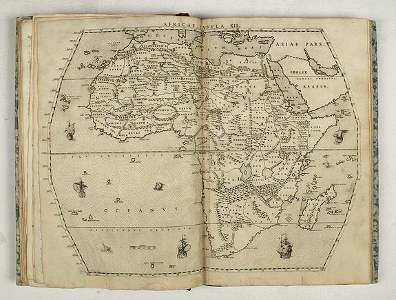
edition of the first printed atlas of Africa, described by R. A.
Skelton as "a methodical and precisely documented description of the
geography of Africa."
sold
The maps were drawn by Sanuto and finely engraved by his brother Jules. The atlas is divided into twelve books, the first containing notes on scientific observation, the declination of the magnetic needle and corrections to the work, the second explains the divisions of Sanuto's prospective description of the world, and the other ten on Africa which was the only section he completed before his death.
Livio Sanuto (c.1520-1576), was a Venetian cosmographer, mathematician and maker of terrestrial globes. Sanuto was one of the so-called Lafreri school of engravers, whose output signaled the transition between the maps of Ptolemy and the maps of Mercator and Ortelius.
Livio and his brother Giulio, planned a massive and comprehensive atlas to include maps and descriptions of the whole world, which he believed would be more accurate than any previously published. Unfortunately, he died in 1576 having only completed 12 maps of Africa.
The 12 maps were eventually published in 1588 by Livio's brother Giulio, under the title "Geografia Di M. Livio Sanuto.".In the compilation of this and the other African maps, Sanuto relied on Gastaldi's 1564 map and Portuguese sea charts for the mapping of the coasts and for information about the interior, used accounts by Duarte Barbosa and João de Barros.After its publication in 1588, this work was copied by other leading map makers for nearly a century afterwards.
Seas are decorated with contemporary sailing vessels and monsters. Etching with engraving.
An interesting feature of the maps is that many of the names are created using punch letters, stamped into the printing plate, as an alternative to individually engraving each letter by hand.
Five sets of punches seem to have been used, for different sizes of letter. This is one of the last appearances of maps lettered in this way. "As it is impossible for the thorough student of mediæval geography to budge an inch without having read the works of Marino Sanuto, so no thorough student of historical geography, especially African and American of the last half of the sixteenth century, can touch bottom in his subject till he has digested this work of Livio Sanuto.
To him more perhaps than to any one writer we owe the clearing up of the subject, and the brushing away the rubbish and blunders of the inland German and French geographers of the previous half century, such as Schoner, Apianus, Münster, Finé and others.
Livio was the son of the Senator Francesco Sanuto, of Venice. In youth he visited Germany to study Mathematics. Being of a practical turn, he made many mathematical instruments, according to the precepts of Ptolemy and others, which were preserved in his family. He next applied himself to Cosmography, and collected out of the best authorities materials for a Terrestrial Globe, in which he was assisted by his brother Giulio, who engraved all the plates. Observing that Africa was imperfectly described, he set to work and compiled this Book with its 12 large maps drawn by himself and engraved by his brother. He intended to publish descriptions of the other parts of the World, but died about 1585 [i.e., 1576], at the age of fifty-six.
The present work is therefore posthumous and was edited by Damiano Zenaro, who dedicated it to Benedetto Zorzi, son of the Signor Aluise. The three excellent Tables of Contents were made by Giovan Carlo Saraceni. The beautiful engraved title page is by Giacomo Franco. "Books I & II treat of Cosmography in general, especially of Latitudes and Longitudes, and how to determine them.
He speaks frequently of the Pilato maggiore Sebastian Cabot, and says that having learned from Oviedo and others that he had explained to Henry VII the variation of the needle, Sanuto became intensely anxious to know Cabot's point of no variation...
At folio 16, he cites Barros, and says it is evident from what he states that Asia cannot be joined to the New World. He goes on to quote Zeno, who makes Engronelandia bounded by the Ocean. He then blames Oronce Finé...and Vopellio for joining Mexico and Cathay, and marvels how they could make such a blunder when Cortes, Gomara, and others had stated that the Mexicans fled at the sight of a horse, an animal which abounds in Asia.
In a similar way, in many instances, he sets matters right. The rest of the volume is a kind of Gazetteer of Africa, arranged in departments."In Book III he begins his geographical description of Africa, by giving first its boundaries and divisions, and then commencing with the Islands on the North-West, he describes the Canaries, the Cape Verde Islands, &c.
Book IV commences with Fez; V with Telensin; VI with Numidia; VII with Gialofo (between the Rivers Canaga and Gambia); VIII contains an account of all the Rivers of Africa (he makes the Nile to rise from two great Lakes in the Kingdom of Prester John), and he then gives the names of all the peoples in Western Africa; IX Abyssinia and Egypt; X Ethiopia; XI Bugia, Barnagaes and Prester John, and XII Lower Ethiopia. "Of course Sanuto describes the manners and customs of Africa in this Gazetteer, but he does it under the name of each place.
Speaking of Cairo, folio 107, he says that they punish a murderer by cutting him in two and putting the upper half of the body, with the head, upon a dish of quicklime, where, he states, it remains alive for a quarter of an hour, keeps on talking, and answers any questions put to it! As to Cattigara, he is of opinion that previous writers have blundered about it, for that in circumnavigating the globe, nothing was found but sea in the place where Ptolemy and others had placed Cattigara, and they thought that if it was in that latitude at all, it might be in the longitude of Peru" (Stevens).
The maps :The twelve full sheet maps comprise a general map of the continent, and eleven regional maps, numbered ‘I’ to ‘XII’ clockwise round Africa, starting at Cape Verde.
Reference: Adams S378. Mendelssohn (1957) II, page 269. Murphy 2212. Sabin 76897. Stevens, Bibliotheca Geographica & Historica, 2461. See also R. A. Skelton's Bibliographical Note to the 1965 facsimile edition of Livio Sanuto's Geograpfia dell' Africa.
